


Displaying items by tag: Galway
New Radar System Could Improve Coastal Forecasts
A new radar system in Galway could help predict extreme weather events more accurately, The Irish Times reports.
Scientists at NUI Galway's Ryan Institute, in collaboration with the IBM Smarter Cities Technology Centre in Dublin, have installed the system on the shoreline in Galway Bay.
The system - the first of its kind in North Atlantic Europe - consists of two antennae, on Mutton Island and Spiddal, which scan the surface of the bay every half hour.
It then sends high-resolutions maps of surface currents and details of wave height and direction directly to the scientists' base at the NUIG campus.
The data is used, along with meteorological data, to develop models for forecasing marine conditions from tidal currents to storm surges - common on the challenging coastline around Galway Bay and the Aran Islands.
Moreover, the system is set to benefit the local community and beyond as the data, when completed, will be made freely available.
Silicon Republic says that the Galway Bay Coastal Observing System (GalCOS) could be used by sailors, fishermen and tourists to more accurately assess conditions in the area.
It could also be of use to local authorities in terms of providing details on the best time to release effluent while minimising environmental damage.
“This type of predictive modelling is critical to our Smarter Cities agenda," said IBM's Dr Lisa Amini, "and the findings can be widely applied to protect coastal cities and their environments."
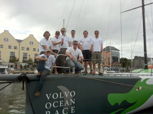
Irish Sailors Get Ready for First VOR In-Port Races
The first of the in-port races ahead of the Volvo Ocean Race start tomorrow in Alicante – and top Irish sailors are among the six teams competing.
Wexford’s Justin Slattery is on Abu Dhabi Ocean Racing, which is competing in the race for the first time.
Skipper Ian Walker told Sail World: "Everything is ready and we can’t wait to line up against the other teams... The forecast is for strong breeze on Saturday so there will be extra pressure on the crew to get it right."
The team has another Ireland connection in its commercial director David Hassett, a veteran of the Irish yachting scene and backer of Ireland's Green Dragon team in the 2009 race.
Elsewhere, Kerryman Damian Foxall is a watch leader on Groupama, captained by debuting VOR skipper Franck Cammas - who last month received one of France's most prestigious sporting honours.
Meanwhile, the Chinese entry Team Sanya, which is part sponsored by Discover Ireland, is hoping skipper Mike Sanderson - who took Telefónica Blue to the podium at every stage in the 2009-09 race - can repeat his past successes.
In-port races take place in all 10 host ports along the 39,000-nautical-mile route, and as they account for more than 20% of the points, no team will be taking them easy.
As previously reported on Afloat.ie, a delegation from Galway - hosts of the final stage of the race next summer - will be in Spain for a week of events beginning tomorrow ahead of the start of the race proper on 5 November.
Sail World has more on the story HERE.
New Round Rockall Race Date to Clash with Round Ireland

Galway Bay Sailing Club has announced details of a new Irish offshore yacht race, the Round Rockall Race 2012 that will start on the same day as Wicklow's biennial Round Ireland race and a week before the Volvo Ocean Race calls to Galway Port on July 5. Both the Round Ireland and Round Rockall races are of similar length, around 700 miles each. An entry limit of 40 boats has been put on the inaugural race. The 2010 Round Ireland race attracted a fleet of 36.
The new offshore race is organised by the Galway Bay Sailing Club (GBSC) and the Round Rockall Race Committee. The start will be from inner Galway Bay on Sunday 24th June 2012 at 1800hrs.
The course will be from a start line in inner Galway Bay and around the islet of Rockall in the North East Atlantic and to a finish
line back in inner Galway Bay. Marks of the Course will be defined in the Sailing Instructions yet to be published. The approximate distance is 652 Nautical Miles.
Entries will be from IRC rated yachts of LOA 9.15m/30 feet and over.
Indicative Class bands which may be modified based on entries received are:
Class 1 : IRC 1.055 - 1.149
Class 2 : 1.00 - 1.054
Class 4 : Two-handed Class
Class 5: Single-handed class
Class 6 : Cruiser Class
Organisers stipulate in the notice of race that 'The Round Rockall Race' is an open ocean race. Every crew member must have experience of sailing a yacht offshore and be prepared to encounter heavy weather. Competitors will be required to provide evidence of offshore experience.
View Larger Map
The full Notice of Race is below.
Round Rockall Race 2012 - Notice of Race
1. ORGANISING AUTHORITY
The Race is organised by the Galway Bay Sailing Club (GBSC) and the Round Rockall Race Committee.
2. RULES
2.1 The race will be sailed under the Racing Rules of Sailing, the ISAF Offshore Special Regulations, and the additions detailed below:
2.1(a) This Notice of Race, the Entry Form and the Sailing Instructions.
2.1(b) The Race is subject to ISAF Offshore Special Regulations Category 1 with the exceptions/ amendments listed in this Notice of Race.
2.2 In the event of conflict the Sailing Instructions shall prevail.
3. START
The start will be from inner Galway Bay on Sunday 24th June 2012 at 1800hrs.
4. COURSE
The course will be from a start line in inner Galway Bay, Ireland and around the islet of Rockall in the North East Atlantic and to a finish line in inner Galway Bay, Ireland. Marks of the Course will be defined in the Sailing Instructions. The approximate distance is 652 Nautical Miles
5. ENTRIES
5.1 Entry forms can be completed online at www.roundrockallrace.com or by post to: Larry Hynes, Caherfinesker, Craughwell, Co. Galway, Ireland.
5.2 The closing date for entries is 1st June 2012.
5.3 Late entries will be accepted, for which there will be a late entry fee.
5.4 Entries will be from IRC rated yachts of LOA 9.15m/30 feet and over, with a minimum SSS of 34 or STIX of 32 combined with an AVS minimum of 130-0.002 x M (where M is minimum sailing weight in kg). STIX and AVS data is required for boats with a series date of 1995 and later.
5.4 A yacht which meets the entry requirements but does not have an IRC rating may enter the Cruiser Class.
6. ENTRY FEE
E250
7. LATE ENTRY
7.1 Late entries will be subject to the entry fee +50%.
7.2 No entry will be accepted after 1st June 2012.
roundrockallrace.com
[email protected]
1/4
8. CANCELLATIONS
Cancellations can be accepted either:
(1) before the closing date, when a refund minus E50 may be claimed or
(2) between the closing date and the start, when 50% of the fee may be claimed.
9. ENTRY
The organisers reserve the right to decline an entry.
10. ENTRY LIMIT
The number of starters shall not exceed forty.
11. CLASSES
11.1 Racing will take place under IRC. Classes will be allocated according to the number and type of entry.
11.2 Classes for cruiser and one design yachts may be assigned subject to the number of entries.
11.3 Indicative Class bands are as follows, (these may be modified based on entries received)
Class 1 : IRC 1.055 - 1.149
Class 2 :1.00 - 1.054
Class 4 : Two-handed Class
Class 5: Single-handed class
Class 6 : Cruiser Class
12. RULES ALTERATION
The organisers reserve the right to alter the rules and conditions of the race at any time. Changes will be posted on www.roundrockallrace.com.
Yachts whose entries have been accepted will be advised directly.
13. EXCEPTIONS AND AMENDMENTS TO THE ISAF OFFSHORE SPECIAL REGULATIONS CATEGORY 1
The following exceptions and amendments to Category 1 regulations apply:
Regulation 3.21.1(ii) not applicable (two separate water tanks not required)
Regulation 3.29.1(n) not applicable (AIS not required)
Regulation 4.08.1 a first aid manual of type listed in (b) is acceptable
Regulation 4.11.2 Reserve Navigation System Clarification: a separate handheld GPS is acceptable as a reserve form of navigation system.
14. EXPERIENCE QUALIFICATION
14.1 The Round Rockall Race is an open ocean race. Every crew member must have experience of sailing a yacht offshore and be prepared to encounter
heavy weather. Competitors will be required to provide evidence of offshore experience.
14.2 The Skipper and at least half the crew must have completed, in the yacht in which they will race the Round Rockall Race, in the 24 months preceding the start:
1. 300 miles of offshore racing* or
2. Non-stop passage of at least 300 miles.
3. Other qualifications similar to 2. above to be proposed to and agreed
2/4
by the organisers by 1st May 2012.
*To qualify as offshore racing a race must be at least 75 miles duration and include at least one night at sea.
15. TRAINING
It is the Skipper's responsibility to ensure that the following criteria are met and that a certificate or letter of attendance from an establishment recognised by the ISA/RORC should be provided on completion of the following:
1. At least 30% of the crew, including the Skipper, shall have undertaken training to Section 6, (Appendix G) of the ISAF Offshore Special Regulations.
2. In the case of two-handed entries, both crew members must complete training to Section 6, (Appendix G) of the ISAF Offshore Special Regulations.
3. In addition at least one member of the crew shall hold a current Senior
First Aid Certificate or equivalent and should be familiar with the management of medical emergencies that may occur at sea, including hypothermia, and radio communications operations for obtaining medical advice by radio.
4. Copies of these certificates must be lodged with the organisers prior to the start of the race.
16. CREW LIST
A full crew list with names, addresses and telephone numbers to be lodged with the Race Office on Registration.
17. INSPECTIONS
Yachts shall assemble at Galway Harbour no later than 1200 hours on Friday, 22nd June 2012 for Special Regulations inspections.
18. SPECIAL REGULATIONS CHECK-LIST
Each entrant must complete an ISAF Offshore Special Regulations Check List and entrants must submit their completed copy to the organisers prior to the start of the race and retain a copy onboard.
19. ADVERTISING
Yachts may carry advertising according to the Racing Rules of Sailing and their class or rating authority. Yachts will be required to fly a race flag and may be required to apply a race sticker to each side of the hull.
20. TRACKING
It may be mandatory for yachts to carry a Tracker Unit for the duration of the race. A refundable deposit, which may be set against a credit-card, may be required.
21. TIDES
Galway Harbour, Sunday 24th June 2012. Times are local and are approximate.
LW: 02:36 1.0m
14:51 1.3m
HW: 08:58 4.5m
21:11 4.7m
3/4
22. RATING CERTIFICATES
22.1 Where necessary, all competitors must apply to the RORC Rating Office
as early as possible prior to the race, in order to obtain their current Certificates in good time.
Please note, STIX and AVS data is required for boats with a series date of 1995 and later.
22.2 The cut-off date for amended Rating Certificates shall be the 1st June 2012.
23. PHOTOGRAPHS
Entrants should include, with their entry, two recent photographs of the yacht for publicity and safety purposes.
24. RADIOS, COMMUNICATIONS & TRACKER SYSTEMS
24.1 If required, entrants shall fit the satellite tracker provided by the organisers.
24.2 The organisers shall be authorised to claim payment for the cost of the tracker if it is not returned at the end of/retirement from the Race.
24.3 Entrants shall have a satellite communication system that allows two way communication throughout the duration of the race (eg Satcom C, mini M, Iridium).
25. SKIPPERS / OWNERS RESPONSIBILITIES
25.1 The safety of each Skipper and boat and her entire management is the sole and inescapable responsibility of the Skipper.
25.2 The Skipper and crew must be physically and psychologically fit to start and continue the Race in the worst of conditions encountered in the North Atlantic.
25.3 The boat must be insured, be of appropriate design and construction,
adequately maintained, equipped and provisioned to meet these conditions.
25.4 Neither the establishment of the Notice of Race, its use by the organisers
or any Sponsoring Organisations, nor any spot check of the boat, under the NOR in any way limits or reduces the complete and unlimited responsibility of each Owner/ Skipper.
25.5 It is the sole and exclusive responsibility of each Skipper and crew to decide whether or not to start or continue to race.
26. DISCLAIMER
26.1 Notwithstanding any other rule and condition, the Organising Authority, Race Committee and Race Sponsors, if applicable, jointly and severally are providing this Race on the understanding that they or their representatives bear no responsibility for any loss, damage, injury, or inconvenience
to boats or persons howsoever arising directly or indirectly from their rules, policy, or rulings before or during the Race or related activities.
26.2 By participating in the Race each Skipper and crew agrees to release the Organising Authority, Race Committee and Race Sponsors from and against all claims, damages, costs, torts, suits at law or in equity or otherwise, arising out of or in any way relating to the Race. This release shall be binding upon each entrant and their heirs, beneficiaries, representatives,
and estates of each entrant.
27. INSURANCE
The Skipper / Owner shall have Third Party Liability insurance cover to a minimum of euro E1,250,000.00 or equivalent.
4/4
Scottish Oyster Shucker to Compete in Galway World Championships
Son of oyster farmers Hugo and Judith Vajk of Caledonian Oysters, Angus won the Loch Fyne Scottish Oyster Opening Championships in Glasgow last month, beating a dozen other competitors including his father!
"I have been opening oysters since before I could walk," he quipped, as he accepted a prize plate from Virginia Sumsion, Marketing and Events Director of Loch Fyne Oysters. "I am thrilled to have won, and excited about going to the world championships, but it will be daunting being up against so many experts. I will be putting in a lot of speed practice this week!"
Part of his prize was a trip to Galway to enjoy the annual international oyster and seafood festival, but Angus had to wait for the organisers of the world competition to confirm that his opening time of 4 minutes 5 seconds for 30 oysters was good enough to allow him to compete there.
"Angus was a worthy winner and we are delighted to sponsor his entry in the worlds. We hope he will do well and bring the cup back home!" said Virginia Sumsion.
Seafood Scotland, which helped to organise the Scottish competition at the Glasgow Riverside Festival, also wishes Angus the very best of luck. "This is the first time ever that the world oyster opening championship has had a Scottish competitor, so it is an honour for Angus to fly the flag for his country," said Marketing Manger Clare Dixon.
Scientists Set to Show Off in Salthill

Hundreds of experts will be showcasing their work in marine science, weather and astronomy in Galway next Friday 23 September, the Galway Advertiser reports.
The special family-oriented Sea2Sky event - organised by NUI Galway in tandem with the Marine Institute and Galway Atlantaquaria - aims to educate the public about the wonders around us, from Ireland's marine wildlife and habitats to the stars and solar system.
The two main venues at Galway Atlantaquaria and Leisureland in Salthill will host various scientific demonstrations on the day, while the promenade between the two will be lined with amateur astronomers and their telescopes.
One of the highlights is sure to be the chance to see the remote submarine used by scientists to explore hydrothermal vents in the north Atlantic this summer.
The full programme of events is abailable at www.sea2sky.ie.
Cave Divers Body Recovered from Galway Cave
Thousands Descend on Galway for Ironman Triathlon

More than 2,000 athletes will take part in Galway's first ever Ironman Triathon this weekend.
The Ironman 70.3 event will comprise a 1.9km swim in Galway Bay, a 90km bike ride through Connemara and a 21.1km run through the streets of the City of the Tribes.
Galway Bay FM confirms that the action will begin tomorrow morning at 7am with the swim from Ladies Beach in Salthill.
But the festivities kick off today with an expo at Salthill Park, followed by a 'pasta party' for the triathletes at the Galway Bay Hotel this evening.
Galway In Talks to Attract Cruise Liners

World tourism bosses and cruise line operators will be headed to Galway next month for high-powered talks aimed at transforming the city into a global destination port.
The Connacht Sentinel reports that execuives from Fáilte Ireland, the Galway Harbour Company and Galway Chamber of Commerce will meet a delegation that will include Jamaica's head of tourism and some of the world's largest cruise line operators to discuss attracting business to the redeveloped port.
As previously reported on Afloat.ie, the proposed €200 million redevelopment of Galway Harbour - which will increase berthing space to accommodate cruise ships - has received approval to submit a planning application to An Bord Pleanála.
Galway West Deputy Brian Walsh, who helped push forward the development plan and will also meet the delegation at the end of September, said that the Galway Harbour Company has set a target of 50 cruise ships a year - which could bring in an extra €40 million annually to the local economy.
The Connacht Sentinel has more on the story HERE.
Green Dragon Sailing for Kinsale then Rotterdam
Galway's round the world yacht, the Volvo 70 Green Dragon, sailed from Galway Port this morning. Her first port of call is Kinsale and on Thursday she will sail for Rotterdam.
From there she will go on a low-loader for Frankfurt to become a static exhibit rather than a sailing craft. She is to appear at the world famous Frankfurt Motor Show where Galway owners say 'she will be put on display in a premier position' - fully rigged - promoting the Volvo Ocean Race 2011 - 2012 and the Race finish in Galway as part of a global village exhibtion showcasing Irish innovation, food and the marine.
The Green Dragon crew who are enroute for Rotterdam via Kinsale
"At this major global exhibition in Germany this will be a fantastic opportunity to showcase Irish Sailing and our plans for 2012 - and also to show our support for Team Sanya our Chinese Irish Volvo Ocean Race Team. A formal send off is planned from Dublin for Team Sanya on Monday 5th Sept", says Enda O'Coineen of Let's Do It Global, who is sailing on the first leg of the voyage to Frankfurt.
Pulsars Discoveries by NUI Galway Astronomers

The team, led by NUI Galway's Dr Andy Shearer, compared optical observations with a detailed model of the structure of the pulsar. From this, using their inverse mapping or reverse engineering approach, they were able to establish for the first time that most of the light from the pulsar comes from close to the star's surface. This is contrary to most pulsar models and points to a new way of analysing observational data from pulsars.

Dr Shearer said: "This is the culmination of ten years work. Our success is based upon having some talented post-graduate students and post-doctoral researchers combined with looking at the problem in a different way. The result shows the importance of our approach of combining numerical models run on large supercomputers with detailed observations. To follow these calculations we will use the SFI funded Galway Astronomical Stokes Polarimeter (GASP)* to finally establish the conditions around a pulsar and solve a forty year old problem - how do pulsars work?"
In another development, NUI Galway astronomers, working with colleagues in Italy, the UK and US, have discovered an X-ray bright tail coming from a pulsar. The tail was discovered by combining optical observations taken with the European Southern Observatory's Very Large Telescope and NASA's Chandra X-Ray observatory. The pulsar, known as PSR J0357, is about half a million years old and is located 1,600 light years from Earth with a tail of over four light years across. These findings have been recently published in The Astrophysical Journal.
Despite over forty years of observation and theory, pulsars, which are rapidly rotating neutron stars, have defied an explanation of how they work. Pulsars are about one and a half times the mass of the sun, but are so small they could fit into Galway Bay. Consequently they represent extreme matter. They have a magnetic field which can be greater than a million billion times stronger than the Earth's magnetic field. Their density is also about a million, billion times greater than the density of the Earth. They are formed during a massive explosion at the end of a star's life known as a Type II supernova. During a supernova, the light from a single star outshines its host galaxy which contains up to a hundred billion stars.
The work at NUI Galway involved observations of the Crab pulsar formed in April 1054 when it was observed as a daytime star – unusually, very few observations of this event come from Europe, although it was observed by Irish monks and recorded in the Irish Annals.


 as lead helm, rounds the Fastnet Rock on the way to the overall win in 1987")

