


Displaying items by tag: World War I
World War I Shipwrecks Revealed In Irish Sea
#HistoricBoats - A team of scientists aboard the Marine Institute's research vessel Celtic Voyager has revealed detailed images of World War I shipwrecks in the Irish Sea.
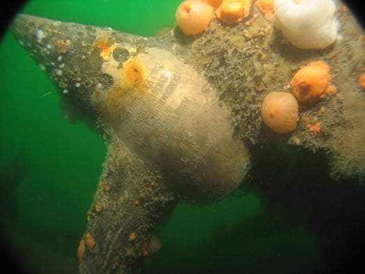
The team, led by Dr Ruth Plets of the School of Environmental Sciences at Ulster University, set out to capture the highest resolution acoustic data possible of WWI shipwrecks lost in the Irish Sea, using a new multi-beam system (EM2040) on board the RV Celtic Voyager to get the best data ever acquired over these wrecks.
"We were able to capture the most detailed images of the entirety of the wrecks ever," said Dr Plets. "Some of the wrecks, which are too deep to be dived on, have not been seen in 100 years. So this is the first time we can examine what has happened to them, during sinking and in the intervening 100 years, and try to predict their future preservation state."
Among the shipwrecks surveyed were the SS Chirripo, which sank in 1917 off Black Head in Co Antrim after she struck a mine; the SS Polwell, which was torpedoed in 1918 northeast of Lambay Island; and the RMS Leinster, which sank in 1918 after being torpedoed off Howth Head, killing over over 500 people - the single greatest loss of live in the Irish Sea.
Marine Institute chief executive Dr Peter Heffernan welcomed the achievements of the survey, supported by the competitive ship-time programme, saying: "The multidisciplinary team is making an important contribution to understanding and protecting our maritime heritage and to our ability to manage our marine resource wisely."
Explaining how the survey was carried out, Dr Plets added: "We moved away from traditional survey strategies by slowing the vessel right down to allow us to get many more data points over the wreck, with millions of sounding per wreck."
"The detail is amazing as we can see things such as handrails, masts, the hawse pipe – where the anchor was stored – and hatches. Some of the vessels have split into sections, and we can even see details of the internal structure. With the visibility conditions in the Irish Sea, no diver or underwater camera could ever get such a great overview of these wrecks."
As well as acoustic imaging, the team collected samples from around the wreck to see what its potential impact is on the seabed ecology. Sediment samples were also taken for chemical analysis to determine if these wrecks cause a concern for pollution.
The project is carried out to coincide with WWI centenary commemorations, noted Dr Plets. "We often forget the battles that were fought in our seas; more emphasis is put on the battles that went on in the trenches. However, at least 2,000 Irishmen lost their lives at sea, but unlike on land, there is no tangible monument or place to commemorate because of the location on the bottom of the sea.
"In the Republic of Ireland there is a blanket protection of all wrecks older than 100 years, so all these will become protected over the next few years. To manage and protect these sites for future generations, we need to know their current preservation state and understand the processes that are affecting the sites."
The next step for the team is to use the data collected to create 3D models which can be used for archaeological research, heritage management and dissemination of these otherwise inaccessible sites to the wider public.
"There is so much data, it will take us many months if not years, to work it all up," said Dr Plets. "Some of the wrecks are in a very dynamic environment and we are planning to survey these vessels again next year to see if there is a change, especially after the winter storms. That will give the heritage managers a better idea if any intervention measures need to be taken to protect them.
"These data could well signal a new era in the field of maritime archaeology. We hope it will inspire a new generation of marine scientists, archaeologists and historians to become involved. Above all, we want to make the general public, young and old, aware of the presence of such wrecks, often located only miles off their local beach."
The research survey was supported by the Marine Institute, through its Ship-Time Programme, funded under the Marine Research Sub-Programme by the Government.
The diverse team included maritime archaeologists Rory McNeary from the Northern Ireland Department of the Environment and Kieran Westley from the University of Southampton; geologists Rory Quinn and Ruth Plets, both Ulster University; biologists Annika Clements from Agri-Food and Biosciences Institute and Chris McGonigle from Ulster University; Ulster University marine science student Mekayla Dale; and hydrographer Fabio Sacchetti from the Marine Institute who works on Ireland's national seabed mapping programme INFOMAR, run jointly with the Geological Survey of Ireland.
The team blogged about the seven-day survey at Scientists@Sea.
Former WW II Oil-Tanker Lays Cables Across Cork Harbour

To read further information about the cable installation project which is listed on the Port of Cork Company website under Notice to Mariners (No. 6 of 2011) click here.
The odd appearance of the barge masks a colourful and chequered career, as only a remnant of the original vessel survives (see photo). Only the forward section and bow (90m long X 20m beam) remain after the partial scrapping of the former oil tanker, Esso København, which took place nearly fifty years ago.
She was launched in 1930 as the MS Peter Hurll by the Palmers Shipbuilding and Iron Company Ltd (Yard/Hull no. 479) at Hebburn-on-Tyne, England. Measuring 11,952grt the tanker was commissioned for Baltisch-Amerik Petroleum Import G.m.b.H. (Waried Tankschiff Rhed.) of Danzig. For further details click here.
The vessel's profile was typical of the era, with a 'two-island' arrangement where the bridge superstructure is sited amidships and separated from the crew's accommodation quarters located aft on the poop deck at the stern.
At 452-foot long, the 17,585dwt vessel had a cargo carrying capacity of 138,108 barrels, which had an assigned pumping rate of 4,000 barrels an hour. The twin-screw diesel powered vessel had 5,300 brake horsepower engines that gave a speed of 12.3 knots.
In 1935 the vessel was sold to the Panama Transport Co. of Panama. While en route to Aruba, with an American crew, war was declared in Europe on September 3, 1939. At the Caribbean island's port of Las Piedras the Peter Hurll loaded her first war-time cargo of 106,514 barrels of fuel and crude oils bound for Everett, Mass.
Throughout the war years the Peter Hurll was crewed at various times between Americans and Danes. To read in greater detail the career history of the vessel and an account of the attempted U-Boat attack on the Peter Hurll click here. The tanker had several sisters, the F. H. Bedford Jr, J. H. Senior, J.A. Mowinckel and The Heinrich v. Riedemann which was lost on April 16, 1942.
Only a few months after the war in February 1946, the Peter Hurll bunkered the Queen Mary, which was moored alongside Pier 90 on the North River, New York. In less than 10 hours the vessel tranferred 27,797 barrels of fuel in a direct tanker-to-ship delivery of fuel oil. The famous 80,000 tonnes Cunard liner which like the tanker, was also built in 1930, had been recently re-converted from a troopship to her peacetime role as a passenger-liner.
In 1967 the liner retired and the vessel is moored at Long Beach, California, as a static hotel, restaurant and museum (see www.queenmary.com).
Two years later the Peter Hurll changed ownership to Det Danske Petroleums A/S of Copenhagen but later under the control of Dansk Esso A/S was renamed Esso København (see link) and the vessel was enlarged to a tonnage of 12,043grt.
In 1952, the vessel was taken to Odense, Denmark by H. J. Hansen, where the vessel was partially broken-up. The remaining fore-end survived and was rebuilt as a cable / pipe laying barge in 1963 (click here). The structure which essentially is a barge was named Henry P Lading for new owners, Nordisk Kabel og Traadfabrikker A/S, Copenhagen.
At one stage the barge was renamed "Nkt Cables a/S" but in 2002 the barge was sold to Jydsk Dykkerfirma ApS, now named JD Contractor A/S. The company (click here) is the largest underwater contractor in Denmark, providing diving assignments and the laying and embedding of submarine cables and pipelines worldwide.
Only late last year, scuba-divers found a fully intact World War I U-Boat on the seabed just outside Cork harbour. To read more about the U-Boat which sank some 93 years ago and photos click here.
German U-Boat Rediscovered in Cork Harbour

Scuba Divers have found a fully intact World War I U-Boat on the seabed just outside Cork harbour, some 93 years after it sank writes Timmy Carey.
During the First World War the menace provided by German U-Boats would prove deadly to the Allies and were responsible for sinking millions of tons of shipping; indeed German U-Boats almost changed the course of the war. Most allied ships sunk by U-boats were sunk by either torpedo, deck gunfire or explosives placed aboard the ship by U-boat crew. A smaller number of ships were also sunk by mine laying U-boats; one of these being UC42. On the 10th of September of 1917 UC42 was laying her deadly cargo of mines at the entrance to Cork harbour when a terrific explosion occurred which resulted in a grim death for all 27 German Submariners aboard.
As the submarine sank to the seabed the German submariners were trapped inside UC42, which would soon become their metal tomb.
On November 2nd of that year, hardhat divers from the Haulbowline dockyard dived the area and positively identified the U-boat as UC42, noting the stern damage to the submarine and the presence of the bodies of some of the German submariners. During 1918 the submarine was dived by Haulbowline and American divers in an effort to disarm all the mines and torpedoes still aboard, with USS Melville taking three of the mines. It was widely believed that in July 1919 divers using explosives from HMS Vernon torpedo school had destroyed the submarine with the remains being dispersed on the seabed by wire sweeps.
With the advent of scuba diving many divers have since searched for the scattered remains of UC42 around Cork harbour with no luck until a recent dive by two local divers Ian Kelleher and Niall O Regan descended a shot line to see the menacing sight of the hull of a German U-boat emerge from the shadows. Both divers were very surprised and ecstatic to find a fully intact World War I U-Boat in 27 meters of water just outside Cork harbour in good condition with little obvious explosive damage from the British naval dive team.
A local dive team of five divers had spent the previous 12 months carrying out a careful methodical search of the greater harbour area determined to find the remains of the submarine; their hard labours finally paying dividends when Niall and Ian identified the presence of the submarine. The dive team consisted of Ian Kelleher, Niall O Regan, Philip Johnston, Eoin Mc Garry and Timmy Carey.
Over the past few weeks the divers have carefully and methodically videoed and photographed the Submarine and taken various measurements to record the wrecks' condition. Over a number of dives the dive team carefully cleaned the growth from the propeller and after some methodical cleaning found the U-Boats number UC42 stamped into it; positively identifying the submarine.
As the submarine is a war grave and contains the remains of so many young German submariners the dive team also laid a plaque of remembrance, which was erected near the submarines propellers; to act as a memorial to the German submariners forever entombed in UC42. The plaque was kindly donated to the dive team by John O' Mahony of Complete Signs.
The image of the U-Boats propellor with the markings identifying the U-Boat. Photo: Timmy Carey
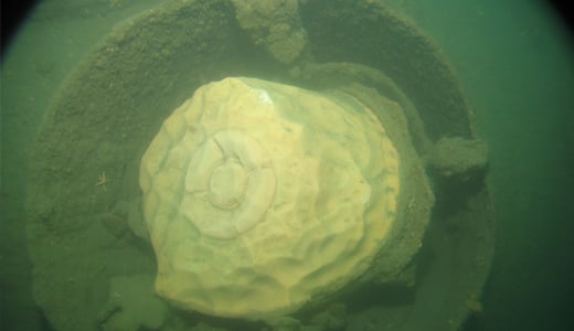
A badly decayed mine on UC42 still in the mine chute. Photo: Timmy Carey


 with his best mate, getting into battle mood in the North African desert during World War II of 1939-45. Anyone who gets along well with a Jack Russell terrier, while looking so very like superstar actor Liam Neeson before Neeson was born, must have had some redeeming features - even if he was a danger to all when partying in a new kitchen")


