


Displaying items by tag: marine science
US Astronaut Kathy Sullivan on Deep Sea Diving, Living Through a Pandemic & Ocean Health

US astronaut and oceanographer Dr Kathryn Sullivan has compared the current global situation to being in the midst of a severe storm on a sailing boat in mid-ocean.
In an interview with The Sunday Times, Dr Sullivan, who has Irish roots, said that although she was an optimist, it was “the most uncertain time I have witnessed in my lifetime”.
“You couldn’t even think of putting a sail back up, let alone trimming it, or trying to steer..only to ride it out as best one can...” she said.
“ It’s a bit like watching the circus performer twirling plates on the end of a stick, relying on gyroscopic forces – but if the twirling slows down any, the plates start to wobble like crazy,” she said
A global pandemic can focus attention on the potential of the ocean environment as a vital source of protein and new medical treatments, she notes.
However, she cautions that the oceans are under considerable pressure, thanks to “we two-footed critters” allowing rubbish to reach the very bottom of the remote Mariana Trench and microplastics to poison the deepest ocean creatures.
“So there is no part of this planet that is disconnected,” she says.
Dr Sullivan, who developed close links with the Marine Institute here during her term as US Under Secretary of Commerce for Oceans and Atmosphere and National Oceanic and Atmospheric Association Administrator (NOAA), has been invited by the institute to give a public “virtual” interview.
Read more of The Sunday Times interview here.
Kathy Sullivan's Exploration From Space to the Sea Floor

The Most Vertical Girl in the World. The woman who's made history in sea and space; The astronaut, oceanographer, explorer, author and the first person to ever experience travelling to both deep space and the oceans deep.
Kathy Sullivan is already in the history books as the first American woman to walk in space in 1984, the 68-year-old found herself making history again just last month.
On June 6, the oceanographer and former NASA astronaut became the first woman to reach Challenger Deep, the deepest known location in the ocean.
The 35,810-foot dive, which was undertaken on the DSV Limiting Factor and co-piloted by Victor Vescovo, now makes Sullivan the first person to both walk-in space and descend to the deepest point in the ocean.
The two missions, total opposites in the minds of many, for Sullivan, come from her one simple desire: to understand the world around her as much as possible.
Join Kathy Sullivan in an exclusive Irish Interview with broadcaster Pat Kenny where she will share her remarkable history-making story, offering unique insights into her exploration at the extreme frontiers, recalling the experiences of walking in space and charting oceans.
You can tune into the Kathy Sullivan in Conversation Livestream on any one of the Marine Institute's social media channels on Thursday, 23 July at 2 pm IST and read Lorna Siggins' interview with Sullivan in The Sunday Times, this week, July 19th.
The Marine Institute says that its fish health inspection and monitoring activities in 2018 and 2019 indicate that there is a high level of compliance with EU and national legislation, and as a result, Ireland continues to maintain its high health status for aquatic animals.
As the Competent Authority, the Marine Institute is legally responsible for implementing EU and national regulation relating to aquatic animal health in Ireland. In this role, the Marine Institute aims to ensure that the existing high health status of aquatic animals in Ireland is maintained.
A new report published by the Marine Institute's Fish Health Unit (FHU) outlines the activities of the FHU in 2018 and 2019 and highlights that there was a high level of compliance with regulatory fish health requirements. A total of 384 health surveillance inspections of aquaculture production businesses were undertaken during this period, and 98% of the 384 sites inspected had no compliance issues or compliance issues that were categorised as minor.
Bill Doré, Manager of the Marine Institute's Fish Health Unit said, "As the Competent Authority in Ireland, the Marine Institute makes an important contribution to preventing and controlling aquatic animal diseases. By working closely with other state agencies to implement aquatic animal health regulations, Ireland is able to maintain its high health status for aquatic animals."
All Aquaculture Production Businesses in Ireland, such as finfish farms, shellfish farms, and put and take fisheries, must obtain a Fish Health Authorisation from the Marine Institute. To receive a Fish Health Authorisation, Aquaculture Production Businesses submit a Fish Health Management Plan for approval. This plan addresses how aquatic animal health will be maintained, and how diseases are controlled, as well as the mandatory conditions for record keeping and reporting to the Competent Authority.
The Marine Institute's Fish Health Unit, working with colleagues in the Department of Agriculture, food and the Marine veterinary services conducts regular health surveillance of fish and shellfish farms in Ireland, and is responsible for regulating the movement of aquatic animals within Ireland and during import or export to and from the state. In the 2018 and 2019 reporting period, over 3,000 movements of aquatic animals were approved.
The Fish Health Unit also hosts the National Reference Laboratories for finfish, mollusc and crustacean health for Ireland. The laboratories undertake testing and applied research to support fish health activities in Ireland. During the reporting period, the laboratories analysed over 1,500 shellfish and 5,000 fish for diagnostic, statutory and research purposes.
Coastal Communities are the focus this week on the Marine Institute’s Oceans of Learning series. The Marine Institute and partners are celebrating our world’s shared ocean and our connection to the sea in a 10-week series, sharing news and offering online interactive activities, videos and downloadable resources on a new marine topic each week
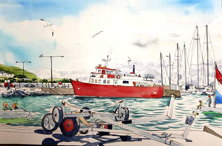
A series of watercolour illustrations and interviews have captured the importance of the ocean to coastal communities in Ireland and Wales as part of BlueFish, an EU-funded project. Through engaging with coastal communities using art, BlueFish links knowledge and understanding of the marine resources and the potential impacts of climate change on the Irish and Celtic Sea ecosystem
"Without the ocean, we wouldn't have a living: it's our only source of income in this rural part of Ireland. Climate change is definitely happening: growth periods are longer than they ever were. But higher water temperatures and higher rainfall could be catastrophic for our business," according to Oyster and mussel fishermen, Cromane, Co. Kerry.
The marine science research project BlueFish is a partnership between six organisations in Ireland and Wales including the Marine Institute, University College Cork, Bord Iascaigh Mhara, Bangor University, Aberystwyth University and Swansea University.
Urban sketcher Róisín Curé and a scientist from the Marine Institute visited coastal communities in Ireland and Wales. Róisín created watercolour illustrations showing the people whose livelihoods are dependent on the ocean and who have a profound and immediate interest in the effects of climate change. Also interviewed were fishermen, restaurateurs, shellfish producers, operators in the tourism sector and seafarers to gather an understanding about how they benefit from the ocean and their thoughts on climate change. The results of the interviews and art through watercolour illustrations created an accessible way for the public to understand the importance the ocean has on livelihoods in coastal communities.
By bringing artists and marine scientists together and working closely with project partners and coastal communities, the Marine Institute has developed a structured portfolio of artwork that is intended to promote a better understanding of the impacts of climate change on ecosystem goods and services; to demonstrate how climate change may impact these; and to highlight the wider societal benefits of healthy ecosystems in Irish and Welsh coastal communities that border the Irish and Celtic Sea(s). The artwork produced as part of the BlueFish project can be viewed in this video.
Dr Paul Connolly, CEO of the Marine Institute explained that "a central part of the project was listening to people living and working in coastal communities, and gathering their opinions about climate change and learning about how it might affect their livelihoods. This was a unique opportunity to talk directly to coastal communities and capture their perspectives through art," Dr Connolly said.
By engaging with people and industries dependant on the sea, the information gathered highlighted how they benefit from the ocean, their thoughts on climate change, and particularly how it was going to affect their lives and businesses.
 Dorans on the Pier at Howth in County Dublin. Illustration by Róisín Curé
"Many of the stories reaffirmed the importance of the age-old relationship between people and the sea, noting that the sea is the life-blood which sustains these communities. The general consensus in both Ireland and Wales coastal communities was that climate change is happening. There was an acknowledgement and a realisation amongst the people interviewed that there was a real looming threat to their livelihoods," said Dr Connolly.
Many people commented on how they were seeing changes to their climate in their local communications. A local businessman from the Isle of Anglesey commented, 'in the 38 years I've been working here, the road would have flooded twice a year. Now it floods much more often.'
The Marine Institute’s Oceans of Learning series this week highlights Ireland’s Coastal Communities. Oceans of Learning offers videos, interactive activities and downloadable resources on our coasts and seashore. Commissioners of Irish Lights offers videos on the work they do to ensure safe navigation around our coast and a colouring book on the Great Lighthouses of Ireland. Find out more about Údarás na Gaeltachta and marine businesses in coastal communities through a series of videos. Discover the animals, seaweeds, plants and creatures along the seashore with the Explorers Education Programme’s Seashore Guide Work Book, and explore the habitats of Galway Bay with activities from Galway City Museum. There are also videos on the Marine Institute's shellfish safety programme and our coastal economy, posters and colouring activities about the marine life found along Ireland's coast.
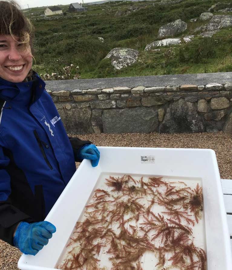
Scientists in West Cork are reporting significant results in use of a type of red seaweed to reduce methane emissions in cattle.
Cuts of between 40 and 98 per cent in emissions have already been achieved in trials in the US, Australia and New Zealand, Bantry Marine Research Station has told The Farmers’ Journal and The Irish Independent.
The West Cork research station, which is now owned by veterinary pharmaceuticals company Bimeda, has been testing effectiveness of red seaweed species Asparagopsis armata in animal feed here.
Canadian scientist Dr Rob Kinley, who pioneered research on its use with the Australian Common Scientific and Industrial Research Organisation (CSIRO), has been collaborating with the Bantry station, managed by David O’Neill.
Asparagopsis armata which was discovered in Irish waters about 60 years ago and cultivated in the late 1990s in Ard Bay, Co Galway by research company Taighde Mara Teo, would have to be farmed here to meet sufficient quantities, O’Neill points out.

He estimates animals fed with the constituent here could reduce emissions by 50 to 60 per cent.
The marine research company is co-operating with Udaras na Gaeltachta and Teagasc, and hopes to raise funds for more animal trials.
Údaras na Gaeltachta director of enterprise, employment and property Dr Mark White said there could be a double benefit for both farmers and climate change targets if the Bantry station’s work on the red seaweed additive does prove fruitful.
Teagasc principal research officer Prof Sinead Waters, who is also adjunct professor at the Ryan Institute, NUI Galway, said that while initial results from Australia and elsewhere are positive, “further research is warranted”.
 Dee McElligott examines the red seaweed Asparagopsis armata in tests at Bantry marine research station, Co Cork
Prof Waters and Teagasc colleague Dr Maria Hayes, are involved in two projects testing various feed additives to reduce methane - “Meth-Abate” funded by the Department of Agriculture, Food and Marine, and “SeaSolutions” an EU- funded project with other Irish, EU and Canadian partners.
“There are a lot of caveats, such as bromoform, a compound within seaweed which is a known to reduce methane emissions but is also a known carcinogen. We need to ensure that if seaweed is fed to ruminants that no bromoform or other residues appear in the end meat and milk products,” Prof Waters said.
For more, read The Farmers’ Journal and The Irish Independent reports here
Celebrating World Oceans Day and this year’s theme of ‘Innovation for a Sustainable Ocean’ is the focus of the Marine Institute’s Oceans of Learning series this week.
As Afloat reported earlier, the Institute and partners celebrate our world’s shared ocean and our connection to the sea throughout the 10-week series, sharing news and offering online interactive activities, videos and downloadable resources on a new marine topic each week.
World Oceans Day (#worldoceansday) takes place on Monday 8 June and connects people globally in celebrating the ocean, its importance to our lives and focusing on how each of us can protect the ocean, no matter where we live. This year, the day particularly focuses on the role that innovation has in making our interactions with the ocean sustainable.
The latest report on the ocean economy from the Organisation for Economic Co-operation and Development (OECD) emphasises the growing importance of science and technologies in improving the sustainable economic development of our seas and oceans. Marine ecosystems sit at the heart of many of the world’s global challenges: food, health and wellbeing, new sources of clean energy, climate change, job creation and inclusive growth.
We need to safeguard and improve the health of marine ecosystems to support our ever-growing use of marine resources. As the challenges to our ocean continue to grow, so too does our need for innovative solutions to address them.
Minister for Agriculture, Food and the Marine, Michael Creed, stated, “Ensuring a sustainable future for our oceans will require stakeholders to focus on innovative mechanisms for addressing both current and future challenges. The Oceans of Learning campaign – One Shared Ocean, One Shared Future - will continue to showcase positive developments across the marine sector in recent years and examples of innovation in action as we approach and celebrate World Oceans Day 2020.”
Dr Paul Connolly, CEO of the Marine Institute, said, “Our ocean is our greatest natural resource and we see that most directly in Ireland with the vital importance that the Atlantic Ocean plays in our daily lives – from facilitating our trade through shipping to influencing the weather and providing seafood to support a healthy diet.
“This year’s theme for World Oceans Day is especially relevant in the lead-up to the UN Decade of Ocean Science for Sustainable Development, which will run from 2021 to 2030, and is born out of the recognition that much more needs to be done to create improved conditions for the sustainable development of our oceans, seas and coasts and to reverse the decline in ocean health.”
Oceans of Learning is marking World Oceans Day by featuring projects that use innovative ways to learn more about our oceans and feed back information that is helping to make a positive impact on our daily lives.
With the aim of driving innovation in the marine sector and accelerating renewable energy breakthroughs, the Marine Institute has provided funding to a number of marine enterprises in Ireland. For example, seven renewable energy projects are benefitting from a significant funding injection following investment by the Institute’s industry-led awards, launched in 2018. From research on the impact of floating platform technology, to subsea micro piling to hybrid solar and wind energy devices, the commercial and scientific potential of these new innovations are very exciting.
Exceedence and Technology from Ideas (TFI) are developing an offshore hybrid system, which will benefit the aquaculture sector. Offshore aquaculture farms, where it is too far to reach with electricity cables from shore, currently use diesel as their main source of energy to operate feed barges and other equipment. This brings concerns of ever growing emissions and the climate impact but also increased risk of oil spillages when transporting diesel to the feed barges.
Energy from the waves is a very attractive alternative energy source. TFI and Exceedence are developing an offshore hybrid power system that harnesses the natural power of the waves by converting the motion of the fish cage into electricity.
Ray Alcorn, CEO at Exceedence said, “Our full hybrid off grid power system technology produces clean blue electricity by harnessing the power of the waves, mitigating the fossil fuel requirements on fish cages, which in turn reduces the overall carbon footprint, improving both environmental and climate impacts.”
Ocean data service company XOCEAN, also received funding from the Institute’s industry-led awards to transform marine monitoring and data collection. The company uses innovative robotics, particularly unmanned surface vessels, to monitor and collect fisheries data at sea. As fish are highly mobile, this brings limitations in using single sonar surveys. XOCEAN is researching and developing a cost-effective way of deploying and using unmanned technology with multiple sonar devices simultaneously to survey for fish in an area, in what’s known as a ‘swarm’ formation.
“XOCEAN is delighted to be working with the Marine Institute on this important project,” said James Ives, CEO of XOCEAN. “Sustainability of fish stocks is of critical importance and management of this depends on high quality data. Unmanned systems, such as XOCEAN’s XO-450 USV have an important role to play in delivering safe, high quality and ultra-low carbon ocean data.”
World Oceans Day encourages us to make a difference in our life, in our community, and in our world, by taking action to protect our ocean – for present and future generations. By working together and thinking creatively, we can achieve a healthier ocean that will provide for the billions of humans, plants and animals which depend on it every day.
My Explorers Seashore Guide Work Book Published on International Biological Diversity Day
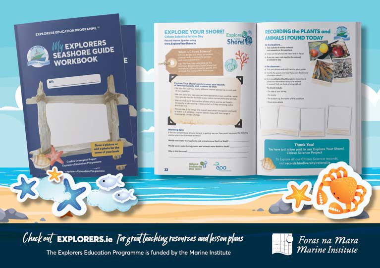
Celebrating the United Nations International Day for biological diversity (22nd May), the Marine Institute's Explorers Education Programme has published My Explorers Seashore Guide Work Book with support from the National Biodiversity Data Centre's Explore Your Shore! project, to raise awareness about our seashore's marine biodiversity in Ireland.
Congratulating the Explorers Education Programme on their collaboration with The Explore Your Shore! project, funded by the EPA, Dr Paul Connolly, CEO Marine Institute said, "The United Nations International Day for biological diversity promotes 'our solutions are in nature' and places an emphasises on solidarity and working together to build a future in harmony with nature. We welcome, therefore, the support of citizen science projects such as this with primary school children."
Leading into the UN Decade of Ocean Science for Sustainable Development and the UN Decade on Ecosystem Restoration (2021-2030), there is an emphasis on a global movement to transform ocean science for a better world. "Taking the time to enjoy and learn more about our seashore, at a local level provides an important opportunity to examine our relationship with our abundant marine environment, creating ocean champions of the future." Dr Connolly added.
"We are delighted to collaborate with the Explore Your Shore! project team and publish an early online version of My Explorers Seashore Guide Work Book that is free to download on www.explorers.ie. The workbook provides a range of activities encouraging children to explore the shore, take photos, draw and write about their discoveries. It also encourages children to become citizen scientists for the day and load snapshots of the species they find to www.ExploreYourShore.ie to help document marine seashore species in Ireland," said Cushla Dromgool-Regan, author of the book and Explorers Education Strategic Manager, Camden Education Trust.
Ireland has 3,171 km of coastline and there are relatively few records of intertidal and coastal marine species. As an island nation, with over half of Ireland's population living 5km from the ocean, the seashore provides a unique opportunity to learn more about the incredible biodiversity that is on our doorsteps.
"With the Explorers Education Programme reaching over 12,000 children in schools annually, we are delighted to feature in the book that will be used later this year in schools. The book supports our efforts to record and increase our knowledge about the distribution of our intertidal species around the Irish coastline. By releasing this fun resource now, we hope that many more children will get the opportunity to start their seashore exploration through their stay at home learning over the summer months," said David Wall, Citizen Science Officer, National Biodiversity Data Centre.
Teachers taking part in the Explorers Education Programme Seashore Safari modules next term will all receive copies of the books for their students in their class. As an early release, the book is now available online at www.explorers.ie for parents to use at home over the next month before homeschooling breaks up.
Loss Ness Mometer & Other Seismometers Retrieved by Dublin Institute of Advanced Studies Expedition
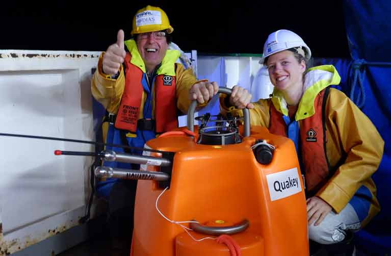
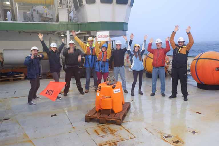
Marine Scientists on the RV Celtic Explorer have collected a network of seismometers recording valuable data over the past 19 months in Irish, British and Icelandic waters.
The 18 seismometers had been deployed in 2018 over a 1500 kilometre area from north to south and over 1,000 km of sea from east to west as part of a project run by the Dublin Institute of Advanced Studies (DIAS).
As Afloat previously reported, a “skeleton” team of six scientists and a small crew on the Marine Institute research vessel went to sea last month to retrieve them and returned to Galway this week after three weeks at sea.
Team leader Dr Sergei Lebedev, DIAS seismologist, said the data captured by the seismometers would “shed light on the nature, occurrence, and frequency of earthquakes off our coast, and is fundamental to our understanding of them”.
“The current nature and history of the ocean floor along Ireland's coast is key to our understanding of how the Atlantic evolved and is evolving, and this is important for better understanding both the natural hazards and natural resources offshore," he said.
"For example, slope failures triggered by earthquakes can generate tsunamis in the Irish offshore territory – the data will give us new insights into this hazard,” he said.
The expedition was “time-critical”, as there were fears the data would be lost if the sensors were not retrieved. Physical distancing measures as part of HSE guidelines on the Covid-19 pandemic were in place for the expedition, according to the DIAS team.
"The seismometers have waterproof memory sticks with recordings of earthquakes off the coast of Ireland. To date, these have been poorly understood, but we know they are generally larger than the ones Ireland has onshore. The new data will give us much greater insights into earthquake mechanisms and, also, into the structure of the Earth's interior,” Dr Lebedev said.
"The instruments have made continuous recordings from the last 19 months of the songs of the great baleen whales, including the blue, fin, humpback and North Atlantic right whales. These unique recordings will build our understanding of the migration patterns of the Earth's largest animals and their acoustic environment, known to be crucially important for them,” he said.
Before the seismometers were deployed in 2018, DIAS ran a competition inviting secondary school students to name each one. Suggestions included “The Dude”, “Gráinne”, “Luigi” and “The Loch Ness Mometer”.
During the retrieval expedition, the research team hosted live video links with school classes from St Francis National School in Wicklow, along with St Joseph's College in Tipperary, and a school in Calabria, Italy.
Self Isolating Scientists Head to Sea on Celtic Explorer
A team of scientists who have been self-isolating like astronauts for the past fortnight set sail from Galway at the weekend on an unusual mission.
Six researchers from the Dublin Institute for Advanced Studies (DIAS) and 15 crew on Marine Institute’s Celtic Explorer will retrieve a network of ocean bottom sensors which were deployed across the entire Irish offshore area 18 months ago.
Ireland’s earthquake activity and data on more distant seismic events, along with the movements of migratory whales, were measured by the 18 seismometers, which must now be retrieved from the ocean.
Strict social distancing measures will be applied on the ship, with staggered meal times and no access to the gym or sauna for the first two weeks of the three-week voyage.
The scientists travelled by private bus directly from their individual homes, and will all have separate cabins as part of the protocol to protect against the Covid-19 virus.
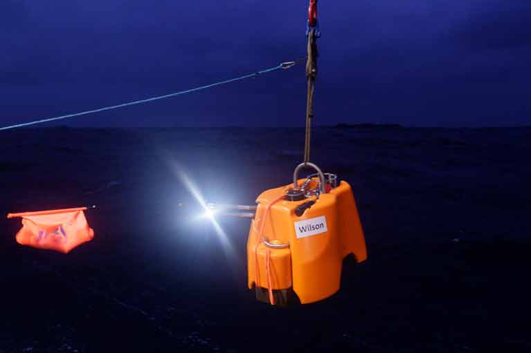 A sensor being deployed in 2018 - The technology aims to record Irish offshore earthquakes
As Afloat reported at the time, the sensors were deployed from the Marine Institute ship in September 2018 by a team led by Dr Sergei Lebedev, a seismologist with the DIAS.
DIAS school of cosmic physics director Prof Chris Bean says the deployment was “by far the most comprehensive in both Europe and the north-east Atlantic”.
“There are specific seismically-active zones where clusters of these types of instruments have been placed before, but this is a first for Ireland,” Prof Bean said.
The sensors aimed to record Irish offshore earthquakes, and research how the earth’s oceans are pressurising the sea floor in really deep water, with big storms possibly triggering submarine landslides and tsunamis.
“The seismometers also have a pressure sensor which can record sound waves in the water – as in whales, dolphins or industrial sounds,” Prof Bean explained.
The deployment was part of the SEA-SEIS project, which aimed to measure movements on the floor of the Atlantic Ocean and register acoustic waves in the water.
“Ninety per cent of Ireland’s territory is offshore, most of it to the west of Ireland. Hidden beneath the waves, there are spectacular mountains, deep valleys, and many extinct volcanoes, similar to those that formed the Giant’s Causeway,”Dr Lebedev said.
The network of seismometers were deployed across an area spanning over 1,500 kilometres from north to south and over 1,000 kilometres from east to west, with some sensors in British and Icelandic and in Ireland’s offshore territory.
“Our mission with this expedition is to retrieve these hugely valuable seismometers, so we can begin the exciting process of analysing the data they have gathered,” Dr Lebedev said.
“This data will shed light on the nature and history of the ocean floor along Ireland’s coast and on the life and movements of the great baleen whales of the North Atlantic,” Dr Lebedev said.
DIAS and the Geological Survey Ireland run the State’s terrestrial network of seismometers to study ground vibrations, ranging from small movements caused by local activities like quarry blasts to large global earthquakes picked up on the Irish network.
The offshore array is a temporary arrangement, Dr Lebedev said.
“This is the first time ever such a large array was deployed, so the data is quite unique and of huge value and that’s why we have to go now.”
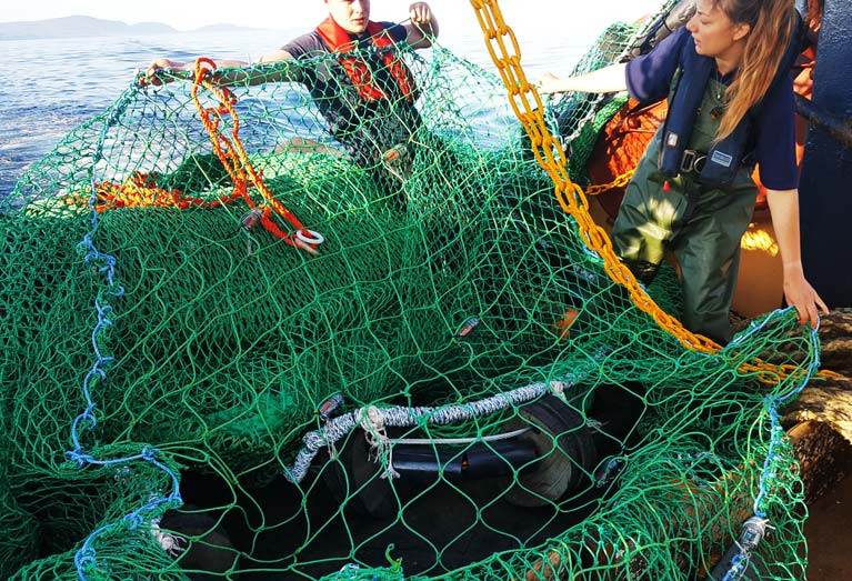
Illuminated exits are as useful to fish as to humans in a tight spot.
Newly published research has found that artificial light on square mesh panels in nets can help to reduce unwanted bycatch of fish.
The study, published in the Marine Biological Association of the United Kingdom, involved trials with two fishing vessels off the Isle of Man from June to August 2017.
 Otter-trawl deployed behind the Queen scallop fishing vessel with a square mesh panel and LEDs inserted into the upper section of the net Photo: Lucy K Southworth
Lead author Lucy K Southworth of Bangor University’s School of Ocean Sciences in Wales notes that use of lights has been tested before, but these trials were particularly successful.
Two 14 metre vessels, Two Girls and Our Sarah Jane, were fitted with a “treatment” and a “control” net which were interchanged between the two after every second day.
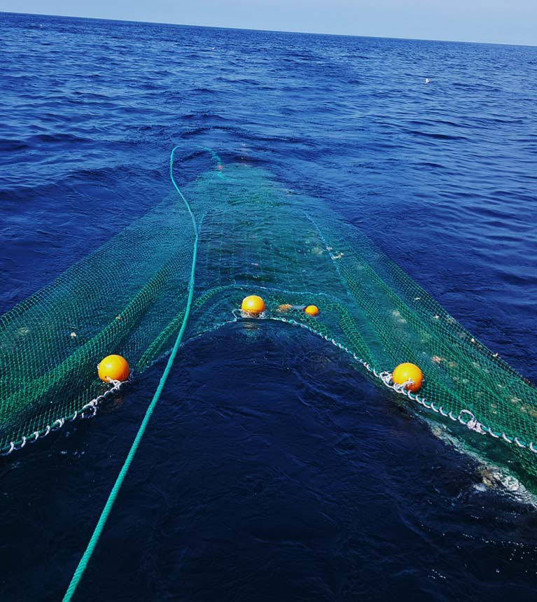
 View from one of the Queen scallop fishing vessels during the bycatch reduction experiment. Vessels fish parallel to one another so that catch comparisons can be made. Photo: Lucy K Southworth)
The weight per unit area of all bycatch species caught in the modified nets, fitted with lights, was lower compared with the traditional “control” nets, and there were no significant losses of the target catch of the two vessels - Queen scallop.
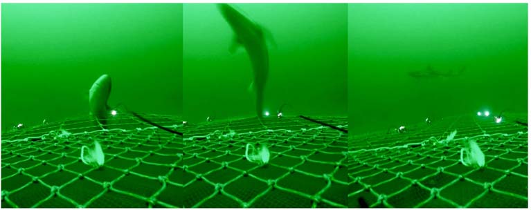 Spurdog (Squalus acanthias) escaping from the illuminated square mesh panel at 29-40m depth. Photo: Lucy K Southworth)
More details are in the April issue of The Skipper magazine.
MORE LIGHT, LESS BYCATCH.
— lucy southworth (@SouthworthLucy) April 17, 2020
In light of the #landingsobligation, @lornasiggins writes in @SkipperEditor about our ? bycatch reduction study using LEDs?
Escape rates for key bycatch species (haddock, whiting, flatfish) differ depending on water depth and light levels...? pic.twitter.com/nauGuzBmDi


 as lead helm, rounds the Fastnet Rock on the way to the overall win in 1987")
