


Displaying items by tag: Seagrass
Marine Scientists Call on Open Water Swimmers and Coastal Walkers to Help Map Seagrass in Galway Bay
Open water swimmers at Galway's Blackrock tower tend to swim east, but scientists would love it if they sometimes swam west – weather permitting.
That’s an area rich in seagrass in Galway Bay, and one of a number of habitats that are of particular interest.
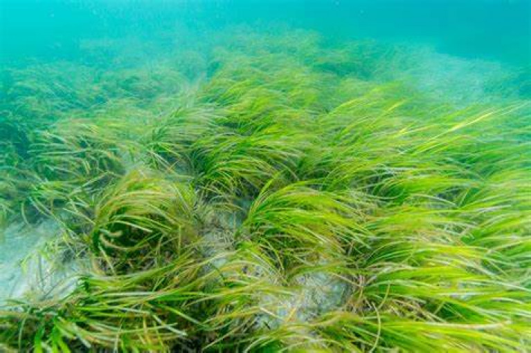
The snake-like grass which moves hypnotically with the waves and grows in meadows in certain coastal areas is an "indicator organism”.
 Dr Noirin Burke of Galway Atlantaquaria
That means it is a type of “underwater canary in the coal mine”, which can signify the health of a marine ecosystem.
") Seagrass (Zostera noltil)
Seagrass (Zostera noltil)
Coastal walkers are being asked to report any signs of seagrass they may find to help complete Ireland’s map of its locations.
 Dr Jonathan Lefcheck of University of Maryland
Galway Atlantaquaria’s Dr Noirín Burke took Wavelengths for a paddle to explain more, and Dr Jonathan Lefcheck of the University of Maryland, who visited Ireland last year, also gave some background on its significance and why citizen science can help.
Coastal nature protection, management and restoration is the theme of a Coastwatch seminar later this month.
The seminar on January 24th in Trinity College, Dublin will focus on seagrass habitat and the Nature Restoration Law.
It will also discuss progress of the Government’s marine protected area (MPA) legislation.
“We have entered a key year for biodiversity,”Coastwatch co-ordinator Karin Dubsky says.
“ In 2023, reports by the Citizen Assembly on biodiversity loss and then the Joint Committee on the Environment and Climate Action were published,” she recalled.
“The EU Nature Restoration Law should pass in February/March and the Irish MPA law follow soon afterwards,” she said.
“The Nature Restoration Law and ongoing measures to designate, manage and restore Natura 2000 sites, offer new opportunities for public participation and citizen science,” she said.
“This Coastwatch seminar will provide an opportunity to review these initiatives against the needs in the coastal zone, where nature is struggling,” she said.
Two sessions will focus on seagrass, as one critically important inshore habitat, and the keynote address will be given by Dr Marcial Bardolet, head of the Posidonia Seagrass Surveillance Service, (IBANAT) Balearic Islands, Spain.
Registration is essential here
“The Serengeti of the seas” is how seagrasses are described by a North American scientist who is concerned about the future of a “forgotten” coastal ecosystem.
Katie May Laumann of the University of Maryland Center for Environmental Science is one of the speakers at a workshop and public lecture today, May 8th, hosted by Galway Atlantaquaria.
Led by Rory O’Callaghan from Seasearch Ireland, speakers at the public lecture will include Jonathan Lefcheck and Katelyn DiBenedetto, MarineGEO Network, Smithsonian Environmental Research Center.
Galway City Council’s biodiversity officer Paula Kearney and Dave Wall, who is the National Biodiversity Data Centre’s citizen science officer, will provide a quick update on current local initiatives.
Galway Atlantaquaria says the event is suitable for members of the local community, 12 years and over. The public lecture starts at 7.30 pm on Monday evening, May 8th, at the Salthill aquarium.
Booking and further details here
Strangford Lough is Piloting Alternative Boat Mooring Systems to Stimulate Seagrass Growth
A pilot scheme on Strangford Lough, which is trying to stimulate seagrass growth on the seabed by testing alternative mooring systems, has been reported by BBC News NI.
Last April, Afloat highlighted a project initiated by the Strangford and Lecale Partnership which started a new pilot study of Advanced Mooring Systems in Strangford Lough. It was the first study of its kind in Northern Ireland to focus on eco-friendly moorings which could avoid or limit the damage caused to the seafloor habitats and species by the swinging chain of traditional boat moorings
Seagrass is a flowering plant able to live in seawater, and its ability to absorb carbon is thought to be greater than that of trees.
The moorings had been laid in Ballyhenry Bay just north of Portaferry on the Strangford Narrows, which DiveNI describes as “a well-established seagrass (Zostera marina) bed with large blades, although it can be patchy in places, especially due to scouring from moorings”.
 circle of seabed Photo: BBC News NI") Dr David Smyth, who inspected the area, says each mooring ship is damaging around a 6m (19.7ft) circle of seabed Photo: BBC News NI
Dr David Smyth, who inspected the area, says each mooring ship is damaging around a 6m (19.7ft) circle of seabed Photo: BBC News NI
BBC NI News says, “According to Darren Rice of Newry, Mourne and Down District Council's geopark team, the traditional mooring system can scar the bottom of the seabed and get rid of the seagrass”. It seems that the mooring systems laid last year are now the subject of the survey. He continues, “We are currently surveying two new advanced mooring systems to see which ones are best for Strangford Lough. So we are hoping these systems will lift the chain off the seabed and allow the seagrass to recover, and that will allow all of the biodiversity to rush back in."
 Zostera marina or Seagrass Photo: National Museum of Nature and Science, Tokyo
On inspection of the trial moorings Conservation Officer Dr David Smyth found, “Beyond the chain of the mooring the seagrass is in pretty good shape; it has a good root system and is well intact into the substrate. But where the chain has swung around the mooring block, it is pretty scarred up. One on its own isn't a particularly big problem, but if you have 10 to 15 of them, you are taking out a six-metre circle with the chain moving in the tide. That's removing that seagrass, that carbon capture plant that everybody is very excited about."
The many sailing clubs around the Lough have mooring sites in dozens of locations, and there are many private moorings as well.
Commercial diver Jonathan Connor was also among those inspecting the trial site, and they found that a few pieces of the chain were missing, so they were replaced.
This pilot scheme is expected to continue for several years to change nothing above the water but stimulate life below.
Coastwatch Fight to Save Vital Native Species Continues
A natural marine resource more important than the rain forests is in danger of dying out unless funding is provided to help protect it.
Zostera Marina is a type of seagrass which grows in the inshore areas of south Wexford, it supports biodiversity, cleans the surrounding water and helps take carbon dioxide out of the atmosphere. However, local seagrass habitats are under threat from the invasive species Sargassum muticum, or ‘wire weed’, which stunts its growth and eventually kills it.
Mick Berry of Coastwatch and local environmentalist Karin Dubsky invited members of the public and government officials to St Patrick’s Bridge in Kilmore Quay to highlight the importance of seagrass and the urgent need to safeguard its future. “England has already lost 92 per cent of its sea grass and Ireland’s levels are patchy, we don’t know how much is left,” said Mick. “We need to map it around the coast of Wexford and identify where it might be. People don’t know what it looks like, even the people living here in Kilmore, they get it mixed up with green algae. At the moment no one is doing anything to preserve it, there’s a lot of red tape holding everything up.”
As a coastal county, Wexford is at the forefront of this fight to protect this vital plant. “Seagrass is one of the top plants for sequestering ocean carbon, its way ahead of the rain forest, it’s so important and it’s right on our doorstep, there’s lots of it in Wexford,” explained Mick. “We’re pushing for funding so we can go out and find it. But we need divers to go and look for it in certain areas, the government department should be doing this not us, we’re doing it out of love.”
Salvation may yet be at hand in the form of the new Maritime Area Planning Bill which is currently before the Oireachteas and includes plans to give local authorities a role in managing inshore coastal areas. It was published on June 29 and coincided with the launch of the National Marine Planning Framework, Ireland’s first national framework for managing marine activities.
Wexford People has more.
Young Boy Joins Grassroots Effort to Protect Vulnerable Seagrass Meadows
In Co Wexford, a seven-year-old boy has joined the grassroots effort to conserve vulnerable seagrass beds around Ireland’s coastline.
According to RTÉ News, Shem Berry has lent a helping hand to volunteers who have been clearing an invasive seaweed, Sargassum muticum, which smothers a seagrass meadow at Kilmore Quay.
Seagrass meadows are considered key ‘blue carbon’ habitats, acting as a natural carbon-capture store while also filtering sediments, keeping shorelines stable and providing a safe home for inshore marine wildlife.
“I think it’s important to look after the environment, not only on land, but on the sea,” said Shem.
As previously reported on Afloat.ie, environmental NGO Coastwatch has called for seagrass habitats to be specified for protection under the State’s new marine planning legislation.
RTÉ News has more on the story HERE.
Coastwatch Calls for Seagrass Habitats to be Specified in New Marine Planning Legislation
Environmental group Coastwatch has called on the Government to specify protection of seagrass beds in new maritime planning legislation.
As The Times Ireland reports, seagrass or Zostera marina is the inshore equivalent of coral reefs or tropical rainforests in nurturing habitats for diverse species.
Seagrass also helps to filter sediments and keep shorelines stable, but a number of such areas in Irish inshore waters are threatened by an invasive species known as “wire weed” or Sargassum muticum.
“These are some of our most valuable blue carbon habitats”, Coastwatch coordinator and marine biologist Karin Dubsky explained at an event held in Co Wexford last week to highlight the issue.
Coastwatch had invited key Government officials and Austrian ambassador to Ireland Dr Thomas Nade to view a seagrass meadow at St Patrick’s Bridge near Kilmore Quay, Co Wexford.
Seagrass beds in Bantry Bay, Co Cork and at Fenit in Tralee Bay, Co Kerry are also at risk of the invasive species, which is at its most dense in May and June.
The new Maritime Area Planning Bill is geared to ensure the regulated development of offshore wind farms but gives local authorities a role in managing inshore coastal areas.
By specifying certain habitats requiring protection, this would empower local authorities to protect seagrass and to remove invasive species like Sargassum muticum, Dubsky said.
The Maritime Area Planning Bill is being progressed ahead of separate legislation on marine protected areas, and this latter legislation could take some years, she said.
“There is huge potential to get things right, but also a huge potential to miss the boat as there is so much marine and coastal development now,” she said.
“We also need to think in terms of inter-county management- the Waterford estuary borders on five local authority areas,” she said.
“We also need to strengthen co-operation between the north and south,” she said.
“This is not a Bill to help the offshore renewable sector get what it needs – this is legislation for all of us, and we have to watch that there isn’t a shortcut,” she said.
Read The Times here
Invasive seaweed is a growing threat to Ireland’s vital seagrass meadows, according to Coastwatch Ireland.
The Irish Times reports on concerns for the health of seagrass habitats around the coast affected by the presence of Sargassum muticum — a brown seaweed that originates in western Pacific waters and has spread in Europe since the 1970s.
In Kilmore Quay, Coastwatch says a large zostera marina seagrass meadow is being killed off by a blanket of the seaweed.
Seagrass meadows are ‘blue carbon’ habitats, acting as significant stores of CO2 captured from the atmosphere. But they are vulnerable and can be easily overrun, says Coastwatch’s Karin Dubsky.
Last October, Afloat.ie noted findings in an Irish Wildlife Trust report that highlighted “significant declines in carbon-sequestering seagrass meadows” in four Special Areas of Conservation.
The Irish Times has more on the story HERE.


 and LE Ciara (P42) depart Cork Harbour on Sunday for disposal in an overseas scrap recycling facility")


 as lead helm, rounds the Fastnet Rock on the way to the overall win in 1987")


