Menu

Ireland's sailing, boating & maritime magazine

Displaying items by tag: virtual marks

In view of the light wind forecast this weekend ISORA are making provisions for a finish outside Dublin Bay for its fourth race of the series from Holyhead to Dun Laoghaire tomorrow. ISORA will also be using virtual waypoints for the 50–mile race.

The forecast appears to be no deterrent as a bumper fleet of 29 has confirmed for the Irish Sea duel. The ISORA fleet nearly broke the 30–boat ceiling except for two unavoidable last minute pull–outs this morning.

The reason behind a Kish light as opposed to a Pier finish is that it is envisaged that there will be no wind in the bay when the fleet arrives late tomorrow afternoon.

The tracker managed finish line – between North Kish and Kish light will give accurate crossing times to within approx five seconds. Is this is the first time an offshore race has been 100% finished using technology alone?

Published in ISORA

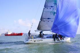
#isora – The arrival of three Howth Yacht Club boats onto the ISORA scene this season has produced immediate results with HYC entry Dux, an X302 yacht skippered by Anthony Gore-Grimes winning the first ISORA race from Dún Laoghaire to Arklow on Saturday. 

Although the strong winds and big seas cancelled most of the local inshore racing for Dublin Bay Sailing Club (DBSC), the 15–offshore yachts came to the line off Dun Laoghaire's East pier in what was some of the strongest breezes of the day. Dux followed by top performing J109 Ruth (Liam Shanahan of the National Yacht Club) made the best of the 40 – knot southerly winds that saw a number of retirals on the upwind leg along the Dublin and Wicklow coasts. Conditions dictated a shortened course to the Wicklow outfall buoy instead of North Arklow, a reduced distance of some 38 miles instead of 50 that produced an early (and welcome) high speed reaching leg back to Dublin Bay.

The provisional results for Race 1a - the Dún Laoghaire day race (incorporating the first Royal Alfred Yacht Club Coastal Series) is available to download below as a jpeg file.

In a move that has drawn the international support of ISAF's offshore working party, the ISORA crews are experimenting with iphone navigation during the race and 'virtual marks' to adjust the courses. 

In deploying the new mobile technology ISORA has teamed up with app developer 'Predict Wind Tracker'. 

Unfortunately on Saturday, ISORA did not get to use them to full effect. The weather was so awful that the basis of the course was to keep as close to land as possible but away from banks and headlands.

This, says Peter Ryan of ISORA, is a cost effective method of recording any offshore race that can be viewed live and also replayed after the event. ISAF's David Brunskill has offered to judge any issues surrounding the use of the virtual marks.

icra6 1

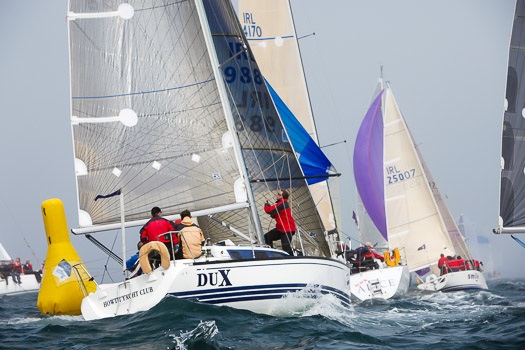
First race winner Dux sailed by seasoned campaigner Anthony Gore-Grimes'  Photo: Robert Bateman

Ryan adds that if the innovative approach to setting courses is successful, 'it will radically change offshore racing to the betterment of all', a sentiment supported by the world sailing body.

The next race is the Holyhead to Dún Laoghaire qualifying race on 10th May. This is followed by the return race from Dún Laoghaire to Holyhead on 24th May. One of the highlights of the ISORA series this year is the Midnight Race from Liverpool to Douglas on 6th June.

Published in ISORA
#ISORA – A sailing race from Conwy in Wales is a new addition to the 2012 Irish Sea Offshore (ISORA) calendar agreed at the weekend that features virtual waypoints for the first time.

It was agreed that virtual marks would be in fixed positions on a trial basis. ISORA Commodore Peter Ryan believes it will 'revolutionise' offshore racing in the Irish Sea and produce better and more exciting racing.

ISORA_Virtual_Waypoints

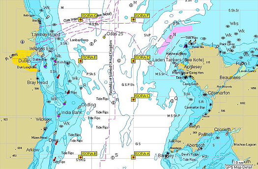
The new ISORA waypoint positions

It was also agreed at the weekend's agm at the National Yacht Club in Dun Laoghaire that there would be two "Restricted / Silver Fleet" classes. The decision of what boats qualify for these classes will be made by the Sailing Committee prior to the first race. It is hoped that this will allow a fairer spread of prizes.

Virtual Waypoints Coordinates:

 ISORA A N52 45.000 W5 08.000

ISORA B N52 45.000 W5 40.000
ISORA C N53 06.000 W5 08.000
ISORA D N53 20.000 W5 08.000
ISORA E N53 20.000 W5 40.000
ISORA F N53 35.000 W5 08.000
ISORA G N53 35.000 W5 40.000

Preliminary Race Programme 2012

28th April - ISORA / RAYC / Lee Overlay Day Race - (50 miles)
Dun Laoghaire to Nt. Arklow Cardinal

5th May - ISORA Offshore - Dun Laoghaire to Holyhead (60 miles)
Qulaifying Race

19th May - ISORA Offshore - Conwy to Howth (100 miles)
Qulaifying Race

2nd June - ISORA Offshore - Pwllheli to Wicklow (100 miles)
Qulaifying Race

27th July - ISORA / RAYC / Lee Overlay Night Race - (35 miles)
Dun Laoghaire to Nt. India Qulaifying Race

18th August - ISORA Offshore - (75 miles) Qulaifying Race
Dun Laoghaire – Pwllheli (T.B.C)

1st September - ISORA / RAYC / Lee Overlay Day Race - (54 miles)
Dun Laoghaire to M2

8th September - ISORA Offshore - Pwllheli to Howth. (80 Miles)

James Eadie Race – Qulaifying Race

Overall Series: To win the overall ISORA series for the Wolf's Head Trophy boats must complete 2
of the 6 "Qualifying". Points for the overall series will then be taken from the best 5
results. Prizes will be awarded for a separate series to include all races in the
schedule.

All races will have a weighting applied.

There will be two Day Races starting and finishing in Pwllheli – dates TBC.


Published in ISORA

About Dublin Port 

Dublin Port is Ireland’s largest and busiest port with approximately 17,000 vessel movements per year. As well as being the country’s largest port, Dublin Port has the highest rate of growth and, in the seven years to 2019, total cargo volumes grew by 36.1%.

The vision of Dublin Port Company is to have the required capacity to service the needs of its customers and the wider economy safely, efficiently and sustainably. Dublin Port will integrate with the City by enhancing the natural and built environments. The Port is being developed in line with Masterplan 2040.

Dublin Port Company is currently investing about €277 million on its Alexandra Basin Redevelopment (ABR), which is due to be complete by 2021. The redevelopment will improve the port's capacity for large ships by deepening and lengthening 3km of its 7km of berths. The ABR is part of a €1bn capital programme up to 2028, which will also include initial work on the Dublin Port’s MP2 Project - a major capital development project proposal for works within the existing port lands in the northeastern part of the port.

Dublin Port has also recently secured planning approval for the development of the next phase of its inland port near Dublin Airport. The latest stage of the inland port will include a site with the capacity to store more than 2,000 shipping containers and infrastructures such as an ESB substation, an office building and gantry crane.

Dublin Port Company recently submitted a planning application for a €320 million project that aims to provide significant additional capacity at the facility within the port in order to cope with increases in trade up to 2040. The scheme will see a new roll-on/roll-off jetty built to handle ferries of up to 240 metres in length, as well as the redevelopment of an oil berth into a deep-water container berth.

Dublin Port FAQ

Dublin was little more than a monastic settlement until the Norse invasion in the 8th and 9th centuries when they selected the Liffey Estuary as their point of entry to the country as it provided relatively easy access to the central plains of Ireland. Trading with England and Europe followed which required port facilities, so the development of Dublin Port is inextricably linked to the development of Dublin City, so it is fair to say the origins of the Port go back over one thousand years. As a result, the modern organisation Dublin Port has a long and remarkable history, dating back over 300 years from 1707.

The original Port of Dublin was situated upriver, a few miles from its current location near the modern Civic Offices at Wood Quay and close to Christchurch Cathedral. The Port remained close to that area until the new Custom House opened in the 1790s. In medieval times Dublin shipped cattle hides to Britain and the continent, and the returning ships carried wine, pottery and other goods.

510 acres. The modern Dublin Port is located either side of the River Liffey, out to its mouth. On the north side of the river, the central part (205 hectares or 510 acres) of the Port lies at the end of East Wall and North Wall, from Alexandra Quay.

Dublin Port Company is a State-owned commercial company responsible for operating and developing Dublin Port.

Dublin Port Company is a self-financing, and profitable private limited company wholly-owned by the State, whose business is to manage Dublin Port, Ireland's premier Port. Established as a corporate entity in 1997, Dublin Port Company is responsible for the management, control, operation and development of the Port.

Captain William Bligh (of Mutiny of the Bounty fame) was a visitor to Dublin in 1800, and his visit to the capital had a lasting effect on the Port. Bligh's study of the currents in Dublin Bay provided the basis for the construction of the North Wall. This undertaking led to the growth of Bull Island to its present size.

Yes. Dublin Port is the largest freight and passenger port in Ireland. It handles almost 50% of all trade in the Republic of Ireland.

All cargo handling activities being carried out by private sector companies operating in intensely competitive markets within the Port. Dublin Port Company provides world-class facilities, services, accommodation and lands in the harbour for ships, goods and passengers.

Eamonn O'Reilly is the Dublin Port Chief Executive.

Capt. Michael McKenna is the Dublin Port Harbour Master

In 2019, 1,949,229 people came through the Port.

In 2019, there were 158 cruise liner visits.

In 2019, 9.4 million gross tonnes of exports were handled by Dublin Port.

In 2019, there were 7,898 ship arrivals.

In 2019, there was a gross tonnage of 38.1 million.

In 2019, there were 559,506 tourist vehicles.

There were 98,897 lorries in 2019

Boats can navigate the River Liffey into Dublin by using the navigational guidelines. Find the guidelines on this page here.

VHF channel 12. Commercial vessels using Dublin Port or Dun Laoghaire Port typically have a qualified pilot or certified master with proven local knowledge on board. They "listen out" on VHF channel 12 when in Dublin Port's jurisdiction.

A Dublin Bay webcam showing the south of the Bay at Dun Laoghaire and a distant view of Dublin Port Shipping is here
Dublin Port is creating a distributed museum on its lands in Dublin City.
 A Liffey Tolka Project cycle and pedestrian way is the key to link the elements of this distributed museum together.  The distributed museum starts at the Diving Bell and, over the course of 6.3km, will give Dubliners a real sense of the City, the Port and the Bay.  For visitors, it will be a unique eye-opening stroll and vista through and alongside one of Europe’s busiest ports:  Diving Bell along Sir John Rogerson’s Quay over the Samuel Beckett Bridge, past the Scherzer Bridge and down the North Wall Quay campshire to Berth 18 - 1.2 km.   Liffey Tolka Project - Tree-lined pedestrian and cycle route between the River Liffey and the Tolka Estuary - 1.4 km with a 300-metre spur along Alexandra Road to The Pumphouse (to be completed by Q1 2021) and another 200 metres to The Flour Mill.   Tolka Estuary Greenway - Construction of Phase 1 (1.9 km) starts in December 2020 and will be completed by Spring 2022.  Phase 2 (1.3 km) will be delivered within the following five years.  The Pumphouse is a heritage zone being created as part of the Alexandra Basin Redevelopment Project.  The first phase of 1.6 acres will be completed in early 2021 and will include historical port equipment and buildings and a large open space for exhibitions and performances.  It will be expanded in a subsequent phase to incorporate the Victorian Graving Dock No. 1 which will be excavated and revealed. 
 The largest component of the distributed museum will be The Flour Mill.  This involves the redevelopment of the former Odlums Flour Mill on Alexandra Road based on a masterplan completed by Grafton Architects to provide a mix of port operational uses, a National Maritime Archive, two 300 seat performance venues, working and studio spaces for artists and exhibition spaces.   The Flour Mill will be developed in stages over the remaining twenty years of Masterplan 2040 alongside major port infrastructure projects.

Source: Dublin Port Company ©Afloat 2020.