


Displaying items by tag: Celtic Voyager
Marine Science Vessel Celtic Voyager Sets Sail to Canada
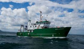
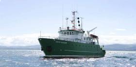
The Marine Institute's Celtic Voyager, Ireland's first multi-purpose research vessel, has been sold to Qikiqtaaluk Corporation of Nunavut, Canada. The vessel has played a significant role in advancing marine science and monitoring for the Irish government during its 25-year service life and has completed more than 600 surveys, enabled more than 6,500 science days, and sailed more than 550,000 miles while in service with the Marine Institute.
Speaking as the vessel departed Irish shores, Michael Gillooly, Interim CEO Marine Institute, said, "We welcome the purchase of the vessel by Qikiqtaaluk Corporation of Canada and are pleased to see that it will continue its work in the areas of fisheries research and seabed mapping in the Nunavut Territory Canada."
The vessel will continue to be used for fisheries research and seabed mapping in Northern territories and Nunavut in Canada. Qikiqtaaluk Corporation is the Inuit birthright development corporation for the Qikiqtani Region and seeks to strengthen the social and economic well-being of Nunavut and the 15,000+ Inuit it represents.
The vessel was operated by P&O Maritime Services Ltd in recent years, and the excellent condition of the vessel is a testament to the crew and shore-based personnel who have sailed and maintained it over the years.
The sale of the Celtic Voyager was facilitated by ship brokers "Hanseatic Offshore Brokers" (HOB).
The vessel has provided a generation of marine scientists, researchers, and crew members with many years of experience at sea, creating abiding memories for them and supporting Ireland's increase in international marine research profile over the last 25 years. The Celtic Voyager's busy annual schedule and wide geographic range provided Ireland with important data and research outputs as the platform delivered a range of national monitoring programs.
The Celtic Voyager has since been replaced in the national marine research fleet by the RV Tom Crean. The Marine Institute bids her a fond farewell and wishes her and her crew and all who sail on her fair winds and following seas.
After 25 years in service with the Marine Institute, the RV Celtic Voyager is now going up for sale.
The RV Celtic Voyager came into service in 1997 as Ireland’s first custom-built multi-purpose research vessel. It has been central to the Marine Institute’s work and research, enabling Ireland as a nation to engage in high-quality marine science and to actively contribute to international research programmes.
The vessel has served the nation well over the past quarter of a century, providing marine scientists, researchers and crew members with many years of experience at sea and enabling us to deepen our ocean knowledge.
The research vessel has played an essential role in fisheries scientific research, and a vital role in seabed mapping in Irish waters as part of the INFOMAR programme.
More than 200 shipwrecks around the coast of Ireland, including the RMS Lusitania, have been mapped by the Celtic Voyager. In 2007, the survey of Galway Bay revealed for the first time a detailed seafloor and geology of the bay, confirming the location of the Galway Bay Fault.
The vessel is currently lying afloat in Howth, Co Dublin. Interested parties can contact the sole agent, Hanseatic Offshore Brokers (details below), to register interest and to arrange viewing. The closing date for registration of interest is Friday 1 September 2023.
Hanseatic Offshore Brokers GmbH
Große Bleichen 32,
20354 Hamburg, Germany
Mobile: +49 173 1 555 351
Email: [email protected]
Web: www.hanseaticoffshore.com
Irish Marine Research Vessels, the Celtic Voyager and Celtic Explorer Celebrated in 'Oceans of Learning' Programme
Oceans of Learning, a collaboration between the Marine Institute and Government departments and organisations across Ireland, this week focuses on Ireland’s national marine research vessels, the Celtic Voyager and Celtic Explorer.
The RV Celtic Voyager came into service in 1997 as Ireland’s first custom-built multi-purpose research vessel. Her purpose was to facilitate the sustainable development of the country’s vast marine resource.
In 2003, the RV Celtic Explorer was commissioned as Ireland’s first deep sea research vessel. At the time of its launch, the Celtic Explorer was the quietest research vessel in the world, meeting international underwater noise requirements essential for fisheries research.
Dr Paul Connolly, CEO of the Marine Institute said, “The Celtic Voyager and Celtic Explorer have been central to the Marine Institute’s work and research, enabling us as a nation to engage in high quality marine science and to actively contribute to international research programmes.
“The new national marine research vessel, RV Tom Crean, comes into service in 2022, replacing the Celtic Voyager. As we look forward to a bright future with the Tom Crean and Celtic Explorer, we take a moment to appreciate the legacy of the Celtic Voyager. The vessel has served us well over the past quarter of a century, providing marine scientists, researchers and crew members with many years of experience at sea, and enabling us to deepen our ocean knowledge.”
The RV Celtic Voyager replaced the 21 metre RV Lough Beltra, which had originally been a fishing trawler. Upgrading to a 31-metre research vessel was the beginning of a new era in marine science in Ireland, as the Marine Institute was able to provide a purpose built platform that could operate further out in Ireland’s ocean territory.
The research vessel has played an essential role in fisheries scientific research, and a vital role in seabed mapping in Irish waters, as part of the INFOMAR programme. More than 200 shipwrecks around the coast of Ireland including the RMS Lusitania, have been mapped by the Celtic Voyager. In 2007, the survey of Galway Bay revealed for the first time a detailed seafloor and geology of the bay, confirming the location of the Galway Bay Fault.
Over close to 25 years, the Celtic Voyager has completed more than 600 surveys, enabled more than 5,000 science days and sailed in excess of 400,000 miles.
The 65 metre RV Celtic Explorer is designed for fisheries acoustic research, oceanographic, hydrographic and geological investigations as well as buoy/deep water mooring and ROV (Remotely Operated Vehicle) Operations. The vessel has a maximum endurance of 35 days offshore and can accommodate up to 35 personnel, including 20-22 scientists.
Expeditions on the RV Celtic Explorer in Irish and international waters have resulted in many exciting discoveries - from deep-water shark nurseries, cold-water coral reefs, to hydrothermal vents fields in the mid-Atlantic.
As part of Oceans of Learning, the Marine Institute’s Voyages video series profiles the people whose work is intertwined with Ireland’s national research vessels. Voyages shares insights into the people behind the science of our seas – Dr Louise Allcock, Professor of Zoology at NUI Galway, and David O’Sullivan, INFOMAR Programme at the Marine Institute – modern explorers on a voyage of discovery to safeguard the ocean and our future.
The Oceans of Learning series on marine.ie offers online interactive activities, videos and downloadable resources all about our ocean. A #SeaToMe social competition will encourage people across Ireland to share what the sea means to them for the chance to win weekly prizes.
Through Oceans of Learning, the Marine Institute comes together with Government Departments and organisations across Ireland including Bord Iascaigh Mhara, Bord Bia, Met Éireann, Commissioners of Irish Lights and EPIC Irish Emigration Museum, to celebrate and highlight the vital role our ocean plays in all of our lives.
R.V. Celtic Voyager to Carry Out Echo Sounder Survey Work
The Marine Institute's Research Vessel Celtic Voyager will carry out marine survey work in the south Irish Sea from March 26th that will involve the use of multibeam echo sounders and sub-bottom profilers.
The work is part of the MOVE 2 Survey in support of ongoing research at the SFI Centre for Energy, Climate and Marine research and innovation.
Grab samples will be taken within a 3 nautical mile range of the locations detailed below and in Appendix 2 of the attached Marine Notice.
Work will be performed on a 24-hour schedule from the RV Celtic Voyager.
 Map of proposed study sites and activities in the Move 2 Survey by the Celtic Voyager
Acoustic surveying using a multibeam echosounder and seismic sub-bottom surveys using a sparker/pinger system will be performed out during both day and night operations in accordance with safe operating practices regarding MMO procedures and cognisant of fishing gear.
Sediment sampling using cores will be carried out during daylight hours due to limited ship mobility. ADCP units will be deployed and retrieved at both night and day as dictated by survey conditions and will be adequately marked according to the Marine Notice.
A provision in today's budget will allow the Marine Institute to commence the planned replacement of the 21-year-old Celtic Voyager with a new 50m modern research vessel that will provide critical national infrastructure to enable Ireland to address the considerable challenges of Brexit and the Common Fisheries Policy as well as climate-induced impacts on our oceans.
Minister for Agriculture, Food and the Marine, Michael Creed T.D., today announced details of his Department’s 2019 €1.6bn Budget. Speaking this afternoon, the Minister also detailed a €78m Brexit Package for farmers, fishermen & food SMEs.
The provision for the Department’s Seafood Programme has been increased by €6 million, to a total of €133.8 million, and this will help fund vital investment in Castletownbere and Killybegs fishery harbours.
Marine Science Vessel RV Celtic Voyager Joins Search for Missing Coastguard Helicopter R116
The Marine Institute ship RV Celtic Voyager is providing specialist support to assist in a major sea search off the county Mayo coast approximately six miles west of Blacksod to locate an Irish Coast Guard helicopter believed to have entered the sea at approximately 1am on Tuesday 14th March.
The Dublin based search and rescue helicopter R116 had been providing 'top cover' during a medical evacuation of a crewman from a UK registered fishing vessel approximately 150 miles west of Eagle Island in County Mayo, which was completed by Sligo based Coast Guard helicopter R118.
The RV Celtic Voyager is assisting with the search operation this morning approximately six miles west of Balcksod. Marine Institute staff from the INFOMAR team, (the national seabed mapping programme) are assisting with the search using specialist multibeam sonar equipment onboard the national research vessel, RV Celtic Voyager.
The search operation is being coordinated by the Coast Guard Rescue Coordination Centre in Malin Head. The RV Celtic Voyager was diverted yesterday from an undergraduate training survey with GMIT, to assist with the search following a request by the Air Accident Investigation Unit of the Department of Transport. Coast Guard search and rescue helicopters, the Air Corps, Navy, RNLI and a number of local fishing vessels are involved in the search operation.
#multibeam – A new multibeam sonar system fitted to the Marine Institute's Research Vessel Celtic Voyager will allow a new level of detail of seabed features to be captured during important mapping surveys around our coast.
It will greatly increase the capability of the vessel to acquire seabed bathymetry data as part of the INFOMAR seabed mapping program and other projects.
See how the new sonar operates in the promo vid below.
The new EM2040 system will be the primary mapping tool during upcoming INFOMAR survey operations offshore County Galway, Clare, and West Cork, extending the Irish seabed coverage around our coast.
This seabed mapping activity will support ocean energy development and fisheries management, and provide improved navigation for safe shipping and transport.
It was successfully installed onboard the RV Celtic Voyager during a recent dry docking in Killybegs, Co. Donegal.
The EM2040 system which was purchased from Kongsberg Maritime was installed on the vessel at the Department of Marine shipyard in Killybegs by P&O Maritime with the assistance of Mooney Boats of Killybegs.
This system replaces an older system which has been in use since 2000.
Calls Now Open For Marine Reaearch Funding Under EUROFLEETS2

#MarineScience - Applications are now being invited under EUROFLEETS2, an EU-funded project providing scientists with 200 fully funded days of ship-time and 104 fully funded days of marine equipment to carry out ship-based research activities within any field of marine sciences.
EUROFLEETS2 - which had its kick-off meeting gathering more than 60 marine scientists and fleet operators in April this year - aims to bring together the European research fleets to enhance their co-ordination and promote the cost effective use of their facilities.
The Marine Institute’s research vessels, the RV Celtic Explorer and the RV Celtic Voyager, are both available to researchers through the EUROFLEETS ship-time call. Irish researchers can apply for ship-time on these and other European vessels participating in EUROFLEETS2.
EUROFLEETS2 invites applications for the following marine research funding opportunities:
Super-Integration: This call seeks to fund a truly cross-cutting proposal, multidisciplinary, multiyear and/or multiplatform, which needs to mobilise a combination of EUROFLEETS Research Vessels (RVs) together with other appropriate scientific tools like nationals RVs, research planes or onshore infrastructures with their own EC or national funding. All EUROFLEETS RVs and equipment are available for this call. More information at www.eurofleets.eu/np4/59
Embarked Equipment: This call offers fully funded marine equipment time within participating scientific marine equipment (two 3D HD TV cameras, two ROVs and the sea floor drill rig MARUM-Mebo) to be deployed from RVs or from underwater vehicles funded by other sources than EUROFLEETS2. More information at www.eurofleets.eu/np4/60
The application deadline for both funding opportunities is 16 September 2013.
EUROFLEETS2 is a Research Infrastructures project under the seventh Framework Programme of the European Commission. For more information and eligibility criteria visit www.eurofleets.eu.

#MarineScience - Gathering more than 60 marine scientists and research fleets operators from all European eco-regions, the kick-off meeting of the European project EUROFLEETS2 was held in Brest, France from 19-21 March last at the invitation of the French Research Institute for the Exploitation of the Sea (Ifremer) and the French Polar Institute Paul-Emile Victor (IPEV).
Thirty-one research organisations, research fleet managers, universities, and industrialists from 20 EU members states or associated countries participate in the EUROFLEETS2 project, whose main objective is the integration of research fleets currently managed at national level.
This project amplifies the effort initiated since 2009 with EUROFLEETS, which ends in August this year. Again co-ordinated by Ifremer, EUROFLEETS2 has a strong operational component. The project receives significant funding from the European Commission (€9 million of a total budget of approximately € 10.8 million) over four years.
“This provides a fantastic opportunity for Irish researchers to access a wide variety of vessel and equipment across Europe,” said Aodhan Fitzgerald of the Marine Institute’s Ocean Science Services Team. “The Marine Institute is proud and pleased to offer ship time on the national research vessels RV Celtic Explorer and RV Celtic Voyager as part of this project.”
EUROFLEETS2 is organised into three complementary activities – trans-national access; joint technological research; and networking - promoting information sharing, identification of new collaborative frameworks, development of common software tools and also testing innovative integration schemes.
Trans-national access offers the opportunity, fully funded by EUROFLEETS2, to international scientific groups to access research vessels on the basis of scientific excellence of the cruise proposals. After seven European calls for ship-time organised within targeted maritime regions, these scientific groups will embark on eight global/ocean and 14 regional European research vessels distributed all over European and world seas and oceans.
Two new initiatives are also planned in EUROFLEETS2: the first aims to attract scientific leaders and/or non traditional end users to make proposals for a flagship project involving several vessels (‘super-integration’ call for ship-time), while the second makes available an original set of five underwater vehicles or scientific embarked equipment.
Joint research, through dedicated actions, contributes to more modern infrastructures and enriched information services. Three key activities are considered: the definition of regional research vessels guidelines and generic designs, the development of innovative functionalities for underwater systems, and the implementation of data acquisition systems in standardised formats, contributing to a higher interoperability between research vessels.
Networking activity will consist in working groups for a better co-ordination of European research fleets. It will aim to establish a common strategic vision including polar research fleets, experiment new integration schemes like the virtual fleets and strengthen links with industry. Floating universities will complement the actions already undertaken for the training of young European scientists.
The long-term objective of EUROFLEETS2 is to prepare the insertion of a group of innovative and inter-operable regional research vessels in the ESFRI(European Strategic Forum on Research Infrastructures) roadmap.
Calls are now open for fully-funded ship time in polar and subpolar regions as well as for expressions of interest in super-integration.
For the former, EUROFLEETS2 can provide 200 fully funded days of ship time and 104 fully funded days of marine equipment to carry out ship-based research activities within any field of marine sciences. The application deadline is 24 May 2013.
As for the latter, the call seeks a cross-cutting proposal that needs to mobilise a combination of EUROFLEETS research vessels together with other appropriate scientific tools like national research vessels, research planes or onshore infrastructures with their own EU or national funding. All EUROFLEETS research vessels and equipment are available for this call. The expression of interest is not binding but desirable.
The deadline for applications is 15 May 2013. Logistically accepted pre-proposals will be invited to submit a full proposal from 14 June till 16 September 2013.
For more information and eligibility criteria visit www.eurofleets.eu.
#MarineNotice - Marine Notice No 15 of 2013 from the Department of Transport, Tourism and Sport (DTTAS) advises mariners that a hydrographic and geophysical survey operation is being undertaken by INFOMAR for the Sustainable Energy Authority of Ireland till 25 April.
The RV Celtic Voyager (Call sign EIQN) is carrying out the survey operations within an area bounded by co-ordinates included in the notice, available as a PDF to read or download HERE.
The vessel is towing a magnetometer sensor with a single cable of up to 100m in length. It is also displaying appropriate lights and markers, and will listen in on VHF Channel 16 throughout the project.
Meanwhile, Marine Notice No 16 of 2013 advises that Shell E&P Ireland is deploying a Waverider buoy off northwest Co Mayo to help predict sea conditions for the laying of an offshore umbilical to the Corrib Gas Field later this year.
The buoy is yellow in colour and will flash yellow five times every 20 seconds. The notice includes an image of what the buoy looks like in the water, as well as the co-ordinates of its placement.
All vessels are requested to give the wave buoy a wide berth.


, marking also a first presence in this market.")


 as lead helm, rounds the Fastnet Rock on the way to the overall win in 1987")


 Michael Murphy Schull Harbour Sailing Club (SHSC), Eric Coogan Heineken Ireland, Mark Murphy, Commodore SHSC, Jack Allen SHSC, Carmel O'Regan SHSC, Cornelious Ndlovu, Schull Harbour Hotel Operations Manager and Derval Murphy SHSC")
