


Displaying items by tag: Buoy moorings
Buoy Moorings Provide New Experiences for Boaters on Lough Erne
Waterways Ireland has installed a new style of moorings on Upper and Lower Lough Erne to create an opportunity for boaters to use and experience the waterway differently.
The 18 new moorings across Upper & Lower Lough Erne are yellow mooring buoys that are permanently attached by chain to an anchor on the lake bed, to which a boat may tie up as an alternative to mooring at a jetty or deploying an anchor.
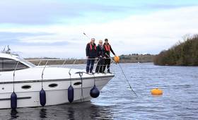
To moor up, a vessel should approach the yellow mooring buoy slowly from downwind. Using a boat hook lift up the pick-up buoy and attached rope out of the water to reach a steel ring. The forward mooring rope should be passed through the steel ring and tied securely from a deck cleat or other strong boat fixing. Users are advised to wear a lifejacket.
German tourists Mark and Melinda using the mooring at Castle Archdale this week on Manor House Marine's Noble Emperor declared it 'really easy'. JP McCaldin from Aghinver Boat Company indicated the moorings would be recommended to their customers as they 'were so simple to use'.
Waterways Ireland's, Director of Business Development, John Boyle, stated "Waterways Ireland is continuing to invest in providing new experiences for waterway users on Lough Erne. The buoy moorings across the Upper and Lower Lake are currently located in 18 locations. Feedback and usage rates will dictate if Waterways Ireland should increase their provision to other locations."
The locations have been chosen to provide safe, sheltered moorings in quiet locations that that will interest boaters with no negative impact or disturbance to bird, fish or mammal species or their habitat. These locations are not intended to give the boater egress to the land, but to provide a safe mooring opportunity away from other waterways users and offering a more intimate connection to nature, which some boaters are seeking. On Upper Lough Erne the moorings are located in Quivvy Lough, Trial Bay, Gole Wood, Creaghmacwallen Island and Tamlaght Bay. On Lower Lough Erne they can be found at Devenish, Inish Fovar, Blaney Bay, Castle Archdale, Strongbow and Rossmore Bay.
In selecting the locations for these moorings Waterways Ireland has paid particular attention to the provision of safe navigation and a safe mooring in a range of water depths and wind directions and the avoidance of overhead electric wires (for craft under sail). Waterways Ireland has also taken into account the weight of craft in designing the mooring anchors to cater for the heaviest cruisers presently on the navigation.
Waterways Ireland Erne Operation staff undertook the design and installation of the moorings across Upper & Lower Lough Erne and are looking forward to receiving feedback from users to [email protected].
Maps and information showing the buoy mooring locations can be found on www.waterwaysireland.org .
Buoy Moorings: Frequently Asked Questions
What is a Buoy Mooring?
A buoy mooring is a mooring buoy that is permanently attached by chain to an anchor on the lake bed at which a boat may tie up as an alternative to mooring at a jetty or deploying an anchor.
Why is Waterways Ireland installing buoy moorings?
Waterways Ireland is installing this type of public mooring to offer boaters an alternative to mooring at a jetty. The locations have been chosen to provide safe, sheltered moorings in quiet locations that will not result in a negative impact or disturbance to bird, fish or mammal species or their habitat. As only one boat can moor at a time, the buoy mooring offers a boater a more natural experience which some boaters are seeking.
What locations have been selected for buoy moorings?
The locations for which Waterways Ireland has sought planning permission are Quivvy Lough, Trial Bay, Gole Wood, Creaghmacwallen Island and Tamlaght Bay on Upper Lough Erne and on Lower Lough Erne at Devenish, Inish Fovar, Blaney Bay, Castle Archdale, Strongbow and Rossmore Bay. Maps are available showing the exact locations.
Are these the only locations in which buoy moorings will be considered?
Waterways Ireland will pilot buoy moorings at these locations and will assess the level of use and listen to boaters in relation to other locations they would like considered for future moorings.
Why has Waterways Ireland chosen these locations?
In choosing the proposed locations Waterways Ireland has sought comment from user groups, the Environment Agency, Inland Fisheries and the RSPB. It is Waterways Irelands intention to provide safe moorings at locations that that will interest boaters but that will not result in a negative impact or disturbance to bird, fish or mammal species or their habitat.
These locations are not intended to give the boater egress to the land, but to provide a safe mooring opportunity away from other waterways users and offering a more intimate connection to nature.
How do you use a buoy mooring?
Each buoy mooring will have a pick-up buoy attached to the mooring buoy. The boat should approach the mooring slowly from downwind. Lift the pick-up buoy using a boat hook and draw it upward til a steel ring is exposed. Pass the forward mooring rope through the ring and back over the boats fairlead and attach to the deck cleat.
What bye-laws apply to buoy moorings?
The Lough Erne Navigation By-laws apply to the buoy moorings, including the 48hour mooring rule.
Has Waterways Ireland considered the environmental consequences of boaters mooring in these locations?
Planning permission is only being given in locations where the moorings will have no negative impact on the environment.
Are these locations 'safe'?
In selecting the locations for these moorings Waterways Ireland has paid particular attention to the provision of safe navigation and a safe mooring in a range of water depths and wind directions and the avoidance of overhead electric wires (for craft under sail). Waterways Ireland has also taken into account the weight of craft in designing the mooring anchors and intends to cater for the heaviest cruisers presently on the navigation.


 leads Kinsale Yacht Club's Cruiser Mid-Week Series")


 is teaming up with BG Freight Line (BGFL) and Peel Ports in Liverpool and Dublin Port to provide a new service to significantly improve transit times in both directions between Ireland and North America. This first ‘eastbound’ sailing for this new integrated service will be operated by combination container/ro-ro (conro) Atlantic Sun (above photo), sailing New York, May 10, Baltimore, May 13, Norfolk, May 14, Halifax, May 16, connecting in Liverpool with JSP Anna, arriving Dublin, May 26 and Belfast, May 27.")


 is Entry No 1 for the three day Howth Wave Regatta, starting Friday May 24th")


