


Displaying items by tag: Barrow Blueway
The Economic Plan for the Barrow Blueway published today (Thursday 22 July) by Heather Humphreys, Minister for Rural and Community Development, promises to maximise the economic impact of the amenity for Co Kildare.
It aims to inform, guide and encourage community and business economic development initiatives that will maximise the opportunity the blueway presents for Kildare while bringing the experience to life for local people and visitors to the area.
The project was delivered in partnership between County Kildare LEADER Partnership, Waterways Ireland and Kildare County Council.
Welcoming the plan’s publication, Minister Humphreys said: “Projects like these will breathe new life into rural Ireland, boost visitor numbers and generate economic activity.
“In March, I launched Our Rural Future — the most ambitious plan for Rural Ireland in decades. This kind of project represent the action behind that policy. I look forward to seeing the Barrow Blueway project progress and the benefits it will be bring to communities.”
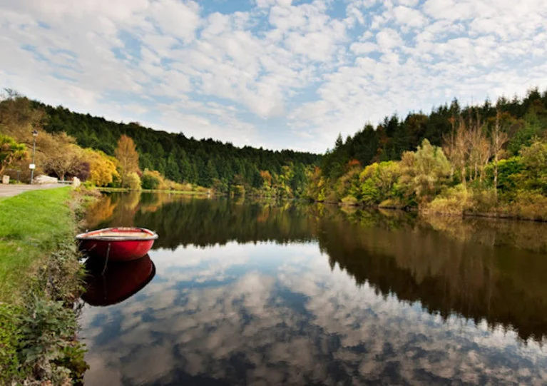
The plan maps the activities and services currently available along the 46km Barrow Blueway route, identifies what is needed and makes recommendations for development, creating a coherent plan for all stakeholders to follow.
Opportunities for business and communities to increase the range of services and tourism spend in their area are clearly highlighted.
Pat Leogue, general manager of the County Kildare LEADER Partnership, said: “LEADER’s role in this plan has been to ensure that communities along the Barrow Blueway have the opportunity to gain from its development through not only social and recreational opportunities but also from the economic benefits that it will provide.
“This plan identifies the best opportunities for each area in a coordinated way which will support employment and provide an important amenity for visitors and residents in Co Kildare.”
Developing a high-quality international visitor experience requires investment from the public and private sector terms of basic infrastructure, and services such as public transport, public toilets, signage and parking, as the plan highlights.
It also notes that visitors to the Barrow Blueway will expect access to a range of accommodation, food and beverage and entertainment options, activities such as cycle hire and guided experiences and chances to engage with nature and heritage.
The project received grant aid from Kildare Local Community Development Committee and support from County Kildare LEADER Partnership financed by the Irish Government under the Rural Development Programme 2014-2020 and by the European Agricultural Fund for Rural Development: Europe investing in rural areas.
Find out more about the Barrow Blueway Economic Plan on the County Kildare LEADER Partnership website, while Waterways Ireland has more information about the planned upgrade of the Barrow Blueway.
Towpath Closures For Blueway Works On Barrow Navigation
Waterways Ireland advises users of the Barrow Navigation that the towpath will be closed in two locations to facilitate works on the Barrow Blueway.
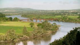
The sections between Milltown Bridge, Athy and Ballymanus Bridge in Vicarstown, and between the 20th Lock in Ballteague and 22nd Lock in Glenaree will be inaccessible for several weeks to allow for the blueway upgrade works.
As previously reported on Afloat.ie, the proposed upgrade aims to improve access to the Barrow Way, both on and along the water, offering an enhanced experience to walkers, cyclists, wheelchairs users, paddlers and families.
Barrow Blueway Works Now Set To Commence Next Week

Works on phase one of the Barrow Blueway are now set to commence this month after the original start date was pushed back by three weeks.
As previously reported on Afloat.ie, the scheme, when complete, will provide a multi-activity 46km off-road, flat and accessible public space and leisure route along the inland waterway running from Lowtown in Kildare, through the towns of Rathangan, Monasterevin, Vicarstown, to Athy.
This coming Tuesday 4 August will see works commence at Milltown Bridge, some 3km north of Athy, with localised closures to facilitate the upgrade of the towpath.
The duration of these works along the towpath this year, under the auspices of Kildare County Council in conjunction with Laois County Council and Waterways Ireland, will be around 16–18 weeks.
The proposed upgrade aims to improve access to the Barrow Way, both on and along the water, offering an enhanced experience to walkers, cyclists, wheelchairs users, paddlers and families.
Barrow Blueway Plan ‘About Much More Than Water-Based Pursuits’
Heritage Minister Josepha Madigan has championed plans to upgrade the Barrow Canal towpath as a 46km blueway as a major economic boon for the communities it connects in counties Laois and Kildare.
The upgrade scheme between Lowtown and Athy in Co Kildare is expected to contribute €2.5 million annually to the local economy, as well as create 90 jobs in the construction phase with around 130 direct and indirect roles in tourism, recreation and hospitality.
Kildare South TD Martin Heydon said it was “a brave decision and the right decision” to go ahead with the 46km section of the 115km proposed Barrow Blueway, suggesting that those who lodged planning objections to the section that was to run through Co Carlow “will, in time, look at us with great envy and wish they had this”.
This past spring, planners blocked proposals for a hard surface path extending to St Mullins in Co Carlow, though the matter divided opinion among locals and users of the waterway.
Asked to comment on the matter by Mr Heydon in recent Dáil questions, the minister said the Barrow Blueway plan as a whole “is about much more than the water and water-based pursuits”.
She continued: “It offers opportunities for walkers and cyclists on the adjacent paths, connecting communities and enhancing the tourism potential of an area by showing off some of its incredible natural amenities.
“It is also about preserving and protecting an artificial ecosystem with diverse species and an important water supply. It is, and will be, a hook … to get people to stay an extra night in the area.”
Asked to confirm whether Waterways Ireland or the relevant local authority has “lead responsibility” for maintenance of the route, Minister Madigan said: “There would be a collaborative approach on the canals.”
She added: “There is no point in having a canal unless it is properly maintained and looked after. Waterways Ireland does as much as it can.
“We want to be able to ensure that people can canoe and kayak, and enjoy a quality experience on our canals. Waterways Ireland is always conscious of that with all its canals.
“There will be challenges in ensuring any kind of quality experience. Waterways Ireland has worked in partnership with Sport Ireland, Fáilte Ireland and other bodies to ensure that.”
The minister also suggested that exploring the possibility of funding from Fáilte Ireland for the project “is certainly something that should be investigated”.
Waterways Ireland recently partnered with Get Ireland Walking to launch the Barrow Way Walk later this month, to help encourage the use of Ireland’s green and blue spaces.
Backed by Sport Ireland, the walking event place next Sunday 29 September in Carlow, Laois and Kildare with routes for different levels of mobility between 5km and 18km.
For further details and how to register to take part, see barrowwaywalk.ie
'Hugely Positive Response' To Barrow Blueway Project

#InlandWaters - Waterways Ireland says it has already received a "hugely positive response" following engagement with interested parties from local communities, activity providers, accommodation and food establishments in relation to the Barrow Blueway project.
A series of public information events have taken place in Carlow, Kilkenny, Laois and Kildare where hundreds attended and viewed the proposals, designs, route selection and surface types.
Waterways Ireland staff were also on hand to deal with any queries in relation to the design and environmental aspects of the Barrow Blueway.
Presentations to the local authorities and their elected members have also taken place in Carlow, Kildare and Laois with the presentation to Kilkenny local authority scheduled to take place in January.
There is also one additional public information event planned to take place in Rathangan, Co Kildare next month.
The cross-border body for Ireland's main inland navigations said it is happy to receive feedback on the project which, together with that received both at the public information events and local authority presentation, will be reviewed and incorporated into the project proposal where possible.
Waterways Ireland will then apply to the relevant authorities for planning approval for the Barrow Blueway project in early 2015.
Waterways Ireland Speaks Out Over Barrow Blueway Concerns
#InlandWaters - Waterways Ireland has responded to concerns over preparatory works connected with the proposed Barrow Blueway.
Described as one of the key recommendations of the Barrow Product Development Study, the development of a 'blueway' scheme along the Barrow Line and Barrow Navigation is still in its "early survey work" stages before any further steps in the planning process, according to the cross-border body for Ireland's inland waterways.
"If the environmental reports are favourable, Waterways Ireland together with the eight agencies [Carlow, Kilkenny, Kildare and Laois County Councils and four Leader companies] will formally apply for planning permission in early 2015," it said in a statement.
"Contrary to speculation, the proposed development of the trackway would entail the use of clean stone and compacted quarry dust to a maximum width of 2m similar to that which is already in use along some of the trackway.
"It is the intention of the agencies to develop this trackway as a sustainable multi-activity leisure route from Lowtown to St Mullins and ultimately linking Dublin to Waterford."
Waterways Ireland also underlined that the Barrow Blueway "is entirely focused on sustainable rural regeneration and development through the provision of a recreational and tourism product of economic and social benefit to the local communities.
"For example, the Great Western Greenway in Mayo of shorter length, contributes an €7.2m annual to the local economy and has helped create 38 new full time equivalent jobs and sustained another 56 jobs."
However, many locals - including broadcaster Olivia O'Leary - have expressed their "horror" at any attempt to disturb the present towpath, a matter that was up for discussion on KCLR FM's Sue Nunn Show last Thursday 14 August.


 is teaming up with BG Freight Line (BGFL) and Peel Ports in Liverpool and Dublin Port to provide a new service to significantly improve transit times in both directions between Ireland and North America. This first ‘eastbound’ sailing for this new integrated service will be operated by combination container/ro-ro (conro) Atlantic Sun (above photo), sailing New York, May 10, Baltimore, May 13, Norfolk, May 14, Halifax, May 16, connecting in Liverpool with JSP Anna, arriving Dublin, May 26 and Belfast, May 27.")


, at the sod-turning event for the new Deep Water Quay Development at the Rossaveal Fishery Harbour Centre. (Forbairt Ché Dhomhain, Lárionad Chuan Iascaigh Ros An Mhíl) in February")

