Menu

Ireland's sailing, boating & maritime magazine

Dublin Bay Boating News and Information

Displaying items by tag: marine technology

The European Commission is seeking proposals to develop a fishing vessel equipped with alternative propulsion technologies and improved energy performance.

The “demonstrator” vessel should foster energy transition in the fisheries sector, and has a budget of 2.2 million euro, drawn from EU pilot project funds.

The Commission lists the expected impacts as:

To develop and demonstrate viable solutions for fishing vessels which improve the energy performance, including reducing greenhouse gas (GHG) emissions and costs;

To increase knowledge on the challenges, benefits and impacts (including economic, environmental and in terms of health and safety of fishers) of different technologies aimed to improve the energy and emissions performance of fishing vessels;

To strengthen understanding of the potential to adapt existing technologies to the fishing sector;

To raise awareness of and broaden the possibilities offered to fishers to become more energy efficient and initiate the energy transition of fishing vessels.

It says long term expected impacts include:

  • Improving the resilience and economic viability of the EU fishing fleet;
  • Improving understanding of technical, social, legal, regulatory and policy barriers to energy transition in fisheries;
  • Reduced fuel consumption and GHG emissions from fishing vessels and improved energy efficiency in their range of activities;
  • Accelerating the adoption of new technologies in the fisheries to foster energy transition;
  • Improving the business environment and raising awareness among investors.

The closing date for proposals is June 11th, and more details are here.

Published in Fishing
5th October 2010

New DIY Copper Protection

Marine Technology Ltd, owner of the CuNiGuard antifouling system, has developed a new, single application copper antifouling product which can be owner applied. Copper-Tek uses a specialised copper which has been extensively tested to create a coating, providing, say the manufacturers many years of antifouling protection from the single application.


During mixing, each litre of Copper-Tek resin is impregnated with 2 kilograms of ultra fine copper powder, the maximum allowed by law. Marine Technology is confident that there is no stronger copper based antifouling system currently available on the market. Following the company's application instructions, a minimum of 200 microns of Copper-Tek is applied, typically the surface will erode at a rate of 5 microns per year. Prior to launch the cured the Copper-Tek surface is lightly burnished with a fine wet and dry paper to allow the copper to activate on contact with the water.


coppertek


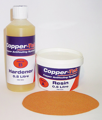
Further burnishing is not anticipated for several years. If ashore for an extended period, a light rub with an abrading pad or fine wet and dry is all that is necessary to reactivate the coating and continue fouling free cruising. Once immersed, the special copper reacts with seawater to form a thin slippery surface covering of cuprous oxide, resistant to all common fouling such as weed, barnacles and other marine growth, but non toxic to the environment. A minimum of 10 years protection should be expected from a properly applied Copper-Tek system.

Using Copper-Tek eliminates the annual labour and high costs of lifting out, preparation and reapplication of antifouling coatings. Previously, high volume copper based products have been prohibitively expensive but Copper-Tek can now offer a DIY option at very reasonable cost. Unlike ordinary antifouling paint, the active Copper-Tek ingredients are hosted by an epoxy resin base which also provides a degree of protection against osmosis in GRP hulls. The treated boat can therefore remain in the water for the owners enjoyment for longer periods.

Copper-Tek is fully approved and licensed for professional and owner application in UK, HSE No 9240 and available from Marine Technology Ltd +44
(0) 1202 887519 or online at www.copperantifoul.com

Published in Marketplace

Dublin Bay

Dublin Bay on the east coast of Ireland stretches over seven kilometres, from Howth Head on its northern tip to Dalkey Island in the south. It's a place most Dubliners simply take for granted, and one of the capital's least visited places. But there's more going on out there than you'd imagine.

The biggest boating centre is at Dun Laoghaire Harbour on the Bay's south shore that is home to over 1,500 pleasure craft, four waterfront yacht clubs and Ireland's largest marina.

The bay is rather shallow with many sandbanks and rocky outcrops, and was notorious in the past for shipwrecks, especially when the wind was from the east. Until modern times, many ships and their passengers were lost along the treacherous coastline from Howth to Dun Laoghaire, less than a kilometre from shore.

The Bay is a C-shaped inlet of the Irish Sea and is about 10 kilometres wide along its north-south base, and 7 km in length to its apex at the centre of the city of Dublin; stretching from Howth Head in the north to Dalkey Point in the south. North Bull Island is situated in the northwest part of the bay, where one of two major inshore sandbanks lie, and features a 5 km long sandy beach, Dollymount Strand, fronting an internationally recognised wildfowl reserve. Many of the rivers of Dublin reach the Irish Sea at Dublin Bay: the River Liffey, with the River Dodder flow received less than 1 km inland, River Tolka, and various smaller rivers and streams.

Dublin Bay FAQs

There are approximately ten beaches and bathing spots around Dublin Bay: Dollymount Strand; Forty Foot Bathing Place; Half Moon bathing spot; Merrion Strand; Bull Wall; Sandycove Beach; Sandymount Strand; Seapoint; Shelley Banks; Sutton, Burrow Beach

There are slipways on the north side of Dublin Bay at Clontarf, Sutton and on the southside at Dun Laoghaire Harbour, and in Dalkey at Coliemore and Bulloch Harbours.

Dublin Bay is administered by a number of Government Departments, three local authorities and several statutory agencies. Dublin Port Company is in charge of navigation on the Bay.

Dublin Bay is approximately 70 sq kilometres or 7,000 hectares. The Bay is about 10 kilometres wide along its north-south base, and seven km in length east-west to its peak at the centre of the city of Dublin; stretching from Howth Head in the north to Dalkey Point in the south.

Dun Laoghaire Harbour on the southside of the Bay has an East and West Pier, each one kilometre long; this is one of the largest human-made harbours in the world. There also piers or walls at the entrance to the River Liffey at Dublin city known as the Great North and South Walls. Other harbours on the Bay include Bulloch Harbour and Coliemore Harbours both at Dalkey.

There are two marinas on Dublin Bay. Ireland's largest marina with over 800 berths is on the southern shore at Dun Laoghaire Harbour. The other is at Poolbeg Yacht and Boat Club on the River Liffey close to Dublin City.

Car and passenger Ferries operate from Dublin Port to the UK, Isle of Man and France. A passenger ferry operates from Dun Laoghaire Harbour to Howth as well as providing tourist voyages around the bay.

Dublin Bay has two Islands. Bull Island at Clontarf and Dalkey Island on the southern shore of the Bay.

The River Liffey flows through Dublin city and into the Bay. Its tributaries include the River Dodder, the River Poddle and the River Camac.

Dollymount, Burrow and Seapoint beaches

Approximately 1,500 boats from small dinghies to motorboats to ocean-going yachts. The vast majority, over 1,000, are moored at Dun Laoghaire Harbour which is Ireland's boating capital.

In 1981, UNESCO recognised the importance of Dublin Bay by designating North Bull Island as a Biosphere because of its rare and internationally important habitats and species of wildlife. To support sustainable development, UNESCO’s concept of a Biosphere has evolved to include not just areas of ecological value but also the areas around them and the communities that live and work within these areas. There have since been additional international and national designations, covering much of Dublin Bay, to ensure the protection of its water quality and biodiversity. To fulfil these broader management aims for the ecosystem, the Biosphere was expanded in 2015. The Biosphere now covers Dublin Bay, reflecting its significant environmental, economic, cultural and tourism importance, and extends to over 300km² to include the bay, the shore and nearby residential areas.

On the Southside at Dun Laoghaire, there is the National Yacht Club, Royal St. George Yacht Club, Royal Irish Yacht Club and Dun Laoghaire Motor Yacht Club as well as Dublin Bay Sailing Club. In the city centre, there is Poolbeg Yacht and Boat Club. On the Northside of Dublin, there is Clontarf Yacht and Boat Club and Sutton Dinghy Club. While not on Dublin Bay, Howth Yacht Club is the major north Dublin Sailing centre.

© Afloat 2020