Menu

Ireland's sailing, boating & maritime magazine

Dublin Bay Boating News and Information

Displaying items by tag: Storm Ellen

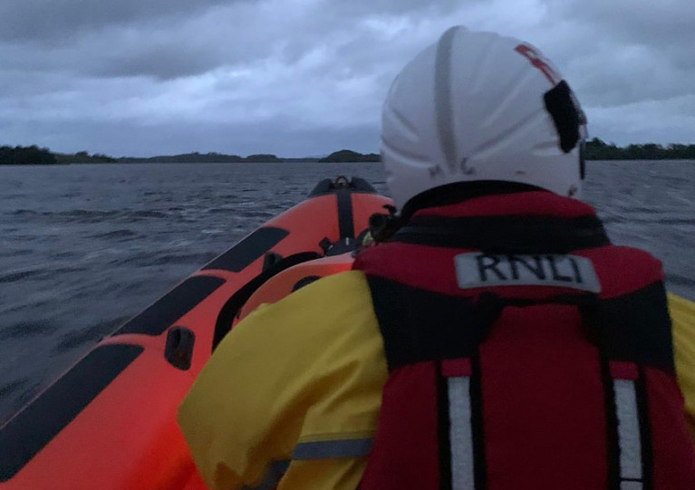
Six people were rescued from their boats on Lough Erne as Storm Ellen swept over Northern Ireland in the early hours of Thursday (20 August).

Enniskillen RNLI said the vessels, which were moored at the Devenish West jetty, were breaking their moorings in the strong winds.

All six passengers across the two brought to safety in Enniskillen aboard the inshore lifeboat.

Meanwhile, three other vessels breaking their moorings at Lough Erne Yacht Club were assisted by the lifeboat station’s shore crew.

Fermanagh braved the worst of Storm Ellen in Northern Ireland, while the Foyle Bridge in Derry had to be closed for a time amid gales and driving rain, as the News Letter reports.

Published in RNLI Lifeboats

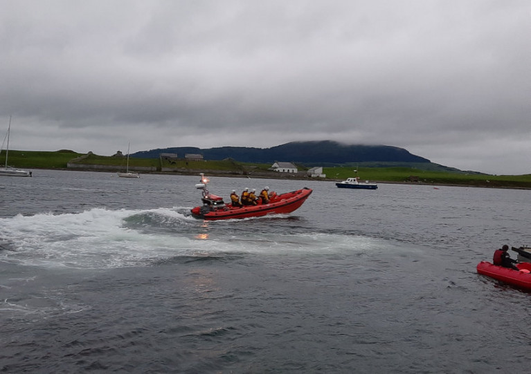
Sligo Bay RNLI volunteers launched last night just hours before the arrival of Storm Ellen to reports of a lone surfer heading out to sea in the fading light.

The inshore lifeboat was joined by the Sligo-based Irish Coast Guard helicopter Rescue 118 as it headed to Strandhill just after 8.30pm yesterday evening, Wednesday 19 August.

Freshening south-easterly winds were blowing 14 knots ahead of the storm’s track north from the West Cork coast.

Once at the scene, the lifeboat crew located the surfer who was able to make their own way ashore.

Speaking following the callout, Aisling Gillen of Sligo Bay RNLI said: “Thankfully this was a happy ending. We would remind everyone of the importance of paying heed to safety warnings during periods of stormy weather and exercise extreme caution.

“Stay back, stay high and stay dry.”

Published in RNLI Lifeboats

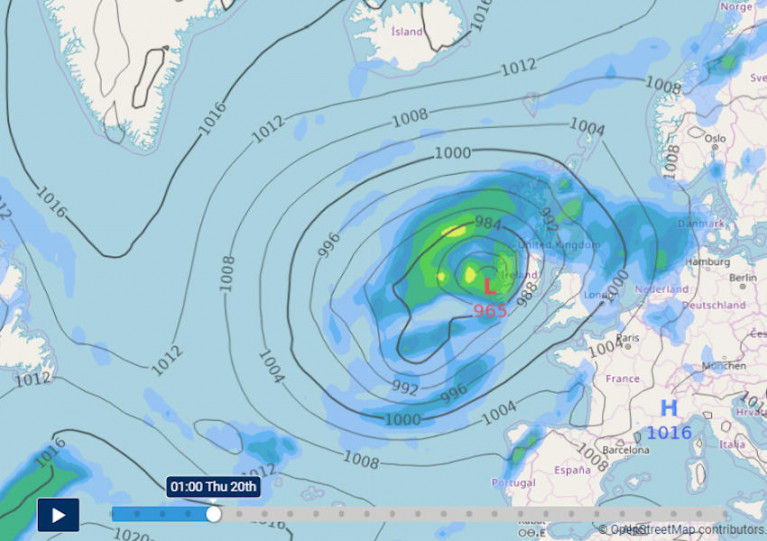
Met Éireann has issued a Status Red marine warning as Storm Ellen approaches today, Wednesday 19 August.

Gale- to storm-force winds, southeast veering southwest, are forecast for this evening and tonight on all Irish coastal waters and on the Irish Sea.

Winds will even reach violent storm Force 11 for a time on the South and West Coasts from Carnsore Point to Valentia to Slyne Head.

From tonight to early Friday the weather may result in unsafe conditions and disruption especially over high ground, lakes and sea areas.

There is also a risk of flooding from storm surges as heavy rains meet spring tides at their highest.

Cork will bear the brunt of the storm, which will produce a core of very severe and destructive winds between 9pm and midnight tonight.

Published in Weather
Tagged under

Dublin Bay

Dublin Bay on the east coast of Ireland stretches over seven kilometres, from Howth Head on its northern tip to Dalkey Island in the south. It's a place most Dubliners simply take for granted, and one of the capital's least visited places. But there's more going on out there than you'd imagine.

The biggest boating centre is at Dun Laoghaire Harbour on the Bay's south shore that is home to over 1,500 pleasure craft, four waterfront yacht clubs and Ireland's largest marina.

The bay is rather shallow with many sandbanks and rocky outcrops, and was notorious in the past for shipwrecks, especially when the wind was from the east. Until modern times, many ships and their passengers were lost along the treacherous coastline from Howth to Dun Laoghaire, less than a kilometre from shore.

The Bay is a C-shaped inlet of the Irish Sea and is about 10 kilometres wide along its north-south base, and 7 km in length to its apex at the centre of the city of Dublin; stretching from Howth Head in the north to Dalkey Point in the south. North Bull Island is situated in the northwest part of the bay, where one of two major inshore sandbanks lie, and features a 5 km long sandy beach, Dollymount Strand, fronting an internationally recognised wildfowl reserve. Many of the rivers of Dublin reach the Irish Sea at Dublin Bay: the River Liffey, with the River Dodder flow received less than 1 km inland, River Tolka, and various smaller rivers and streams.

Dublin Bay FAQs

There are approximately ten beaches and bathing spots around Dublin Bay: Dollymount Strand; Forty Foot Bathing Place; Half Moon bathing spot; Merrion Strand; Bull Wall; Sandycove Beach; Sandymount Strand; Seapoint; Shelley Banks; Sutton, Burrow Beach

There are slipways on the north side of Dublin Bay at Clontarf, Sutton and on the southside at Dun Laoghaire Harbour, and in Dalkey at Coliemore and Bulloch Harbours.

Dublin Bay is administered by a number of Government Departments, three local authorities and several statutory agencies. Dublin Port Company is in charge of navigation on the Bay.

Dublin Bay is approximately 70 sq kilometres or 7,000 hectares. The Bay is about 10 kilometres wide along its north-south base, and seven km in length east-west to its peak at the centre of the city of Dublin; stretching from Howth Head in the north to Dalkey Point in the south.

Dun Laoghaire Harbour on the southside of the Bay has an East and West Pier, each one kilometre long; this is one of the largest human-made harbours in the world. There also piers or walls at the entrance to the River Liffey at Dublin city known as the Great North and South Walls. Other harbours on the Bay include Bulloch Harbour and Coliemore Harbours both at Dalkey.

There are two marinas on Dublin Bay. Ireland's largest marina with over 800 berths is on the southern shore at Dun Laoghaire Harbour. The other is at Poolbeg Yacht and Boat Club on the River Liffey close to Dublin City.

Car and passenger Ferries operate from Dublin Port to the UK, Isle of Man and France. A passenger ferry operates from Dun Laoghaire Harbour to Howth as well as providing tourist voyages around the bay.

Dublin Bay has two Islands. Bull Island at Clontarf and Dalkey Island on the southern shore of the Bay.

The River Liffey flows through Dublin city and into the Bay. Its tributaries include the River Dodder, the River Poddle and the River Camac.

Dollymount, Burrow and Seapoint beaches

Approximately 1,500 boats from small dinghies to motorboats to ocean-going yachts. The vast majority, over 1,000, are moored at Dun Laoghaire Harbour which is Ireland's boating capital.

In 1981, UNESCO recognised the importance of Dublin Bay by designating North Bull Island as a Biosphere because of its rare and internationally important habitats and species of wildlife. To support sustainable development, UNESCO’s concept of a Biosphere has evolved to include not just areas of ecological value but also the areas around them and the communities that live and work within these areas. There have since been additional international and national designations, covering much of Dublin Bay, to ensure the protection of its water quality and biodiversity. To fulfil these broader management aims for the ecosystem, the Biosphere was expanded in 2015. The Biosphere now covers Dublin Bay, reflecting its significant environmental, economic, cultural and tourism importance, and extends to over 300km² to include the bay, the shore and nearby residential areas.

On the Southside at Dun Laoghaire, there is the National Yacht Club, Royal St. George Yacht Club, Royal Irish Yacht Club and Dun Laoghaire Motor Yacht Club as well as Dublin Bay Sailing Club. In the city centre, there is Poolbeg Yacht and Boat Club. On the Northside of Dublin, there is Clontarf Yacht and Boat Club and Sutton Dinghy Club. While not on Dublin Bay, Howth Yacht Club is the major north Dublin Sailing centre.

© Afloat 2020