Displaying items by tag: Newry Canal
Loughs Agency Issues Biosecurity Advise As Invasive Zebra Mussels Are Spotted in Newry Canal
Fishery officers from the Loughs Agency recently observed zebra mussels (Dreissena polymorpha) near Victoria Lock at the Newry Canal.
Zebra mussels are an invasive non-native Species (INNS), meaning they have been transported outside of their natural geographic range only to proliferate in their new environment, contributing to habitat loss, species extinction, ecosystem impacts, risks to human health and economic impacts.
Multiple specimens from a range of age classes were observed in the Newry Canal during low water conditions at the end of the summer. The presence of several age classes suggests an established, spawning population, the Loughs Agency says.
Zebra mussels were first recorded in Ireland in 1997 on the lower part of the navigable Shannon system, although it is believed that the species may have actually arrived years earlier. They were first reported in Northern Ireland in 1998 at Lower Lough Erne and, by 2010, a confirmed spawning population was present in Lough Neagh.
Although zebra mussels are now widespread across the island of Ireland, they still present a number of significant ecological, social and commercial threats to native systems. The introduction of this invasive species can lead to unprecedented ecological changes, which occur as a result of zebra mussel settlement, filter feeding and excretion. The combination of these factors has the potential to significantly alter native ecosystems.
Social and commercial factors associated with zebra mussel invasions involve the detrimental effects of mussel ‘biofouling’ on man-made structures such as recreational and commercial watercraft, water intake and cooling systems on industrial plants, jetties and pontoons.
Other economic issues arise from the potential loss of income or employment as a result of the negative ecological impacts, which includes a reduction in the density of an economically valuable species. These impacts all have financial implications in terms of management, mitigation and prevention.
Loughs Agency chief executive Sharon McMahon said: “Invasive species have arrived and are continuing to arrive across the island of Ireland through a variety of vectors, almost universally caused by human actions. Therefore, it is imperative that preventative measures are taken to avoid further spread and introductions.
“It is the responsibility of all water users to ensure that invasive non-native species are not transferred between water bodies. Do not introduce zebra mussels to any new sites and all sightings of the species should be reported. Avoid fouling of boats and equipment, and ensure everything is clean before moving to any new waterbodies. In addition, do not move ballast water between waterbodies.“”
Invasive Species Northern Ireland recommends the ‘Check Clean Dry’ approach for best practice in biosecurity on Ireland’s waterways. For further details on INNS found within the Foyle and Carlingford catchments, visit the Loughs Agency website.
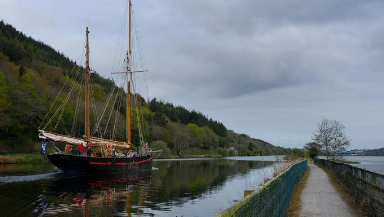
A 130-year-old heritage tall ship named ‘Leader’ has docked in Newry, Co.Down where it will be used for the benefit of the local community.
The Brixham trawler was formerly a survivor of the fleets of sailing fishing boats that once fished in the Irish Sea.
Northern Ireland Sailing Charity, Silvery Light Sailing, has received a National Lottery Heritage Fund grant of £244,975 for the acquisition of the 1892-built heritage tall ship to host community sailing programmes and further expand their traditional boat building skills workshops.
Sailing from Bristol’s Underfall Yard after dry docking and a maintenance refit, the 130-year-old Brixham trawler, arrived at the Albert Basin in Newry, County Down.
The heritage vessel is again destined to become a familiar sight in Northern Ireland’s ports providing a unique sailing experience for local youth and community groups, public open days and festivals.
Further coverage from the Belfast Telegraph and also from Silvery Light Sailing’s social media channels @SilveryLight.
O'Donovan is Afloat Rower of the Month for November
# ROWING: The Afloat Rower of the Month for November is Paul O’Donovan. The 18-year-old lightweight sculler covered the five-kilometre time trial on Newry Canal faster than any other competitor in the National Assessment. The Skibbereen man finished fourth in the single sculls at the World Junior Championships in 2011. He is now on scholarship to University College, Dublin.
Rower of the Month awards: The judging panel is made up of Liam Gorman, rowing correspondent of The Irish Times and David O'Brien, Editor of Afloat magazine. Monthly awards for achievements during the year will appear on afloat.ie and the overall national award will be presented to the person or crew who, in the judges' opinion, achieved the most notable results in, or made the most significant contribution to rowing during 2012. Keep a monthly eye on progress and watch our 2012 champions list grow.
Shillington's Quay in Portadown Set for Revamp
Shillington's Quay in Portadown is set for redevelopment thanks to a significant grant from the European Union.
The Portadown Times reports that half of the borough's £200,000 (€230,000) funding will be used for a new floating jetty and environmental improvements for the Newry Canal quay area, which was last used as a working port in the 1930s.
A total of £2.5 million (€2.9 million) has been earmarked by the EU for promoting tourism in the cross-border East Border Region, which aside from six Northern Ireland council areas also includes the Irish counties of Louth, Meath and Monaghan.
Other improvements to marine and waterway facilities include a £125,000 (€145,000) investment for the Eisenhower Pier in Bangor, on the southern side of Belfast Lough.
The Portadown Times has more on the story HERE.


