Menu

Ireland's sailing, boating & maritime magazine

Dublin Bay Boating News and Information

Displaying items by tag: Labrador

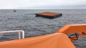
#RNLI - Ballyglass RNLI’s lifeboat crew had an unusual callout on Monday evening (14 May) when they were launched to recover a runaway barge that had drifted to the Mayo coast across the Atlantic from Canada more than 3,000km away.

The large floating barge had broken from its moorings in Labrador in north-east Canada last November, and after six months at sea was spotted and reported by a passing fishing vessel earlier on Monday.

Ballyglass RNLI received the call to launch last night at 7.20pm. On arriving on scene, the lifeboat crew found a steel barge measuring 26 metres by 16 metres, which was unsecured and floating.

The lifeboat crew established a tow and brought the barge back to Ballyglass Harbour.

However, with no room to berth such a large barge safely, it was put on the lifeboat mooring before a more permanent solution could be found. The crew were not stood down until 2am this morning.

All in all, it took the lifeboat crew seven hours to secure the barge and and bring it safely to Ballyglass.

Commenting on the shout, Ballyglass RNLI lifeboat operations manager Padraic Sheeran said: “We were not expecting this type of callout at all. You do hear of vessels and craft breaking free of moorings but it’s unusual to have one drift thousands of kilometres and have to be rescued by lifeboat.

“On a serious note though, it represented a major navigational danger to any vessel that it collided with and it was a relief to have it safely recovered.”

The callout will remind Afloat.ie readers of the houseboat that drifted from Newfoundland to the Mayo coast in November 2016.

Published in RNLI Lifeboats
In his first week in office Marine Minister Simon Coveney has moved to highlight the significance of the marine sector to Ireland. The statement came in his first official engagement at the new Department of Agriculture, Marine and Food. Minister Coveney said: "the seas and ocean that surround the island of Ireland are among this country's greatest natural resources."

The Minister was speaking during a visit to the Marine Institute's research vessel, RV Celtic Explorer, on its return from a mission to the Labrador and Newfoundland Seas.

He added "I am particularly pleased that this is my first official engagement as Minister for Agriculture, Marine and Food. The work of the RV Celtic Explorer highlights the essential nature of marine research, development and sustainable management, through which Ireland is developing a strong and well-deserved reputation as an emerging centre of excellence, where we have prominent roles in many European and international marine science bodies."

Minister Coveney commended the Marine Institute and its Chief Executive, Dr Peter Heffernan, for its leading and proactive role in the areas of fisheries science, marine environment and food safety as well as ocean science and said that he looked forward to working closely with the Institute and benefitting from the research and advice which they would undertake and provide.

The Minister noted that Ireland's two national research vessels – RV Celtic Explorer and RV Celtic Voyager – will record 267 days at sea during 2011, during which they will be engaged in fisheries surveys, underwater mapping, climate studies and deepwater surveys.

Published in Marine Science
The Marine Institute has issued a statement congratulating Mr Simon Coveney TD on his new appointment as the Minister for Agriculture, Marine and Food today (11th March 2011), during his visit on board the RV Celtic Explorer in Cork, after its return from the mission to the Labrador and Newfoundland Seas.

Seeing the capabilities of Ireland's largest research vessel and the work of the Marine Institute, Mr Simon Coveney highlighted the importance the Marine Sector has on the Irish economy. "The seas and ocean that surround the land of Ireland is arguably one of our countries greatest natural resources. Through marine research, development and sustainable management, Ireland is developing a strong reputation as an emerging centre of excellence, where we have prominent roles in many European and international marine science bodies," he said.

Ireland's national research vessels RV Celtic Explorer and RV Celtic Voyager will record 627 days at sea between the two during 2011. Their work will range from fisheries surveys to underwater mapping and from climate studies to deepwater surveys with the remotely operated submersible ROV Holland 1.

"The work conducted on the vessels continues to feed into the success in attracting EU funding to Ireland's marine science programmes that have been achieved by our strategic approach to marine science planning" explained Dr Peter Heffernan, CEO of the Marine Institute.

"The award of funding projects shows that partnerships between academics and small businesses can yield significant dividends in creating jobs, generating economic revenue and the supply of raw materials for new industries ranging from ocean energy and environmental monitoring technologies to marine-inspired pharmaceuticals and food ingredients" he further said.

Published in Marine Science

Dublin Bay

Dublin Bay on the east coast of Ireland stretches over seven kilometres, from Howth Head on its northern tip to Dalkey Island in the south. It's a place most Dubliners simply take for granted, and one of the capital's least visited places. But there's more going on out there than you'd imagine.

The biggest boating centre is at Dun Laoghaire Harbour on the Bay's south shore that is home to over 1,500 pleasure craft, four waterfront yacht clubs and Ireland's largest marina.

The bay is rather shallow with many sandbanks and rocky outcrops, and was notorious in the past for shipwrecks, especially when the wind was from the east. Until modern times, many ships and their passengers were lost along the treacherous coastline from Howth to Dun Laoghaire, less than a kilometre from shore.

The Bay is a C-shaped inlet of the Irish Sea and is about 10 kilometres wide along its north-south base, and 7 km in length to its apex at the centre of the city of Dublin; stretching from Howth Head in the north to Dalkey Point in the south. North Bull Island is situated in the northwest part of the bay, where one of two major inshore sandbanks lie, and features a 5 km long sandy beach, Dollymount Strand, fronting an internationally recognised wildfowl reserve. Many of the rivers of Dublin reach the Irish Sea at Dublin Bay: the River Liffey, with the River Dodder flow received less than 1 km inland, River Tolka, and various smaller rivers and streams.

Dublin Bay FAQs

There are approximately ten beaches and bathing spots around Dublin Bay: Dollymount Strand; Forty Foot Bathing Place; Half Moon bathing spot; Merrion Strand; Bull Wall; Sandycove Beach; Sandymount Strand; Seapoint; Shelley Banks; Sutton, Burrow Beach

There are slipways on the north side of Dublin Bay at Clontarf, Sutton and on the southside at Dun Laoghaire Harbour, and in Dalkey at Coliemore and Bulloch Harbours.

Dublin Bay is administered by a number of Government Departments, three local authorities and several statutory agencies. Dublin Port Company is in charge of navigation on the Bay.

Dublin Bay is approximately 70 sq kilometres or 7,000 hectares. The Bay is about 10 kilometres wide along its north-south base, and seven km in length east-west to its peak at the centre of the city of Dublin; stretching from Howth Head in the north to Dalkey Point in the south.

Dun Laoghaire Harbour on the southside of the Bay has an East and West Pier, each one kilometre long; this is one of the largest human-made harbours in the world. There also piers or walls at the entrance to the River Liffey at Dublin city known as the Great North and South Walls. Other harbours on the Bay include Bulloch Harbour and Coliemore Harbours both at Dalkey.

There are two marinas on Dublin Bay. Ireland's largest marina with over 800 berths is on the southern shore at Dun Laoghaire Harbour. The other is at Poolbeg Yacht and Boat Club on the River Liffey close to Dublin City.

Car and passenger Ferries operate from Dublin Port to the UK, Isle of Man and France. A passenger ferry operates from Dun Laoghaire Harbour to Howth as well as providing tourist voyages around the bay.

Dublin Bay has two Islands. Bull Island at Clontarf and Dalkey Island on the southern shore of the Bay.

The River Liffey flows through Dublin city and into the Bay. Its tributaries include the River Dodder, the River Poddle and the River Camac.

Dollymount, Burrow and Seapoint beaches

Approximately 1,500 boats from small dinghies to motorboats to ocean-going yachts. The vast majority, over 1,000, are moored at Dun Laoghaire Harbour which is Ireland's boating capital.

In 1981, UNESCO recognised the importance of Dublin Bay by designating North Bull Island as a Biosphere because of its rare and internationally important habitats and species of wildlife. To support sustainable development, UNESCO’s concept of a Biosphere has evolved to include not just areas of ecological value but also the areas around them and the communities that live and work within these areas. There have since been additional international and national designations, covering much of Dublin Bay, to ensure the protection of its water quality and biodiversity. To fulfil these broader management aims for the ecosystem, the Biosphere was expanded in 2015. The Biosphere now covers Dublin Bay, reflecting its significant environmental, economic, cultural and tourism importance, and extends to over 300km² to include the bay, the shore and nearby residential areas.

On the Southside at Dun Laoghaire, there is the National Yacht Club, Royal St. George Yacht Club, Royal Irish Yacht Club and Dun Laoghaire Motor Yacht Club as well as Dublin Bay Sailing Club. In the city centre, there is Poolbeg Yacht and Boat Club. On the Northside of Dublin, there is Clontarf Yacht and Boat Club and Sutton Dinghy Club. While not on Dublin Bay, Howth Yacht Club is the major north Dublin Sailing centre.

© Afloat 2020