


Displaying items by tag: Havhingsten
Post-Lay Inspection and Burial of Havhingsten Fibre Optic Cable in Irish Sea From This Weekend
Further to previous installation works on the Havhingsten fibre optic telecommunication cable system in the Irish Sea, post-lay inspection and burial (PLIB) of the cable is planned to begin later this week.
Works outside Irish and Isle of Man territorial waters are will start on Friday 14 January and continue until next Thursday 20 January, subject to weather.
It is advised that extra care is taken when vessels are operating near this area and that no vessel should trawl within 500m.
Installation will be via industry-standard burial tools including water jetting with remote operated vehicle (ROV). The target cable burial depth is 1.5m below seabed level in the region.
There will be two locations where PLIB will be performed: at Final Splice (FS) location outside Irish territorial waters, and at Branching Unit (BU) location outside of Isle of Man territorial waters.
The operations will be conducted by the cable installation vessel CS Ile d’Aix (callsign FICI) which will be working on a 24-hour basis, and will display appropriate day shapes and lights during reduced visibility and night operations.
All vessels operating within this area are requested to keep their distance and pass at minimum speed to reduce vessel wash.
For more information, including coordinates and contact details, see Marine Notice No 01 of 2022 attached below.
Rock Placements Ahead of Fibre Optic Cable Works in Irish Sea
Further to last week’s Marine Notice advising of the latest works on the Havhingsten fibre optic telecommunication cable system this month, rock placement activities in the Irish Sea are also planned from this weekend.
There are four crossing locations in the Irish Sea where rock placement will be installed from this Saturday 11 December, but only one will be within the Irish EEZ, at the offshore extent.
Rock placement will be via industry standard, and activity at each site will last for up to 15 hours.
The operations will be conducted by the cable installation vessel Stornes (callsign PCKX), which will operate on a 24-hour basis and display appropriate day shapes and lights during reduced visibility and night operations.
All vessels operating within this area are requested to keep their distance and pass at minimum speed to reduce vessel wash.
Further details, including relevant coordinates and contact information, can be found in Marine Notice No 65 of 2021 which is available to download below.
Fibre Optic Cable Installation Works Continue in Irish Sea This Month
Installation of the Havhingsten fibre optic telecommunication cable system in the Irish Sea inside of the Irish 12-nautical-mile zone is planned for this month.
It follows works this past autumn in the Irish Sea outside of territorial waters, as previously reported on Afloat.ie.
Works are planned to start on Monday 13 December, subject to weather and full execution of the foreshore licence.
The latest operations on the cable route for the western Irish Sea region, which lands at Loughshinny, will be conducted by the cable installation vessel CS Île de Batz (callsign FOSU).
It will be working on a 24-hour basis and will display appropriate day shapes and lights during reduced visibility and night operations.
All other vessels operating within its work area are requested to keep their distance and pass at minimum speed to reduce vessel wash.
Details of the coordinates of the work area and contact information can be found in Marine Notice No 64 of 2021, which can be downloaded below.
Installation of the Havhingsten fibre optic telecommunication cable system is planned from Monday 23 August until Thursday 23 September in the Irish Sea outside of the Irish 12-nautical-mile zone.
Works within 12 nautical miles of Ireland’s mainland are planned from December 2021 subject to weather and operational conditions.
There will also be associated rock placement operations post-cable installation at four locations within the western Irish Sea and these works are expected in between October and December, weather permitting.
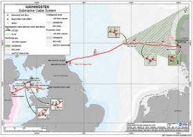
The entire cable system will comprise marine elements that pass from Denmark to the UK (NE region), and from the UK (NW) to Ireland, with two segments installed into landfalls on the Isle of Man. The cable route for the western Irish Sea region lands at Loughshinny in north Co Dublin.
Installation will be via industry standard burial tools including water jetting and ploughing. Target cable burial depth is 1.5m below seabed level in the region.
It is anticipated that installation operations in UK/Irish waters will occupy up to a maximum 500m width (250m either side of cable). The cable itself will occupy only 40mm of the seabed. Expected speed of installation will be approximately 17km per day.
Works will be conducted by the cable installation vessel CS Recorder (callsign MATL3) which will operate 24 hours a day and will display appropriate day shapes and lights during reduced visibility and night operations.
All vessels operating within its vicinity are requested to keep their distance, and pass at minimum speed to reduce vessel wash.
Full details, including coordinates for the work areas and rock armour placements, are included in Marine Notice No 45 of 2021 which can be downloaded below.
Fibre Optic Cable Laying In The Irish Sea This Weekend
Marine Notice No 13 of 2019 advises that a pre-lay grapnel run and route clearance operations will be conducted in Irish waters for three days from tomorrow, Friday 31 May, to Sunday 2 June as part of installation of the marine part of the Havhingsten submarine fibre optic cable system.
The operations schedule is provisional, and will be subject to change due to external factors, including but not limited to weather, equipment or vessel downtime.
The location of the pre-lay grapnel run in Irish waters is indicated by Seg 1.1 in the map featured above, between Lat 53° 50.9' N, Long 004° 59.4' W and Lat 53° 38.6' N, Long 005° 40.5' W.
The pre-lay grapnel run will be completed by the cable ship Ile d’Aix (Callsign FICI). The vessel will be linked to the bottom by the cable and will have poor manoeuvrability capacities. It will signal that it has restricted ability to manoeuvre with shapes and/or lights as required by international regulations.
All vessels are requested to keep a clear distance from the cable laying vessel of at least 0.5 nautical miles. The cable laying vessel will broadcast regular safety messages giving its current position and activity.


 were up 8.3% in the first four months of this year, according to today’s trading statement.")


 Bureau Veritas.")


