Menu

Ireland's sailing, boating & maritime magazine

Displaying items by tag: Wave buoy

TechWorks Marine has scheduled the deployment of a wave buoy off the coast of Wicklow on Tuesday 8 December, weather allowing.

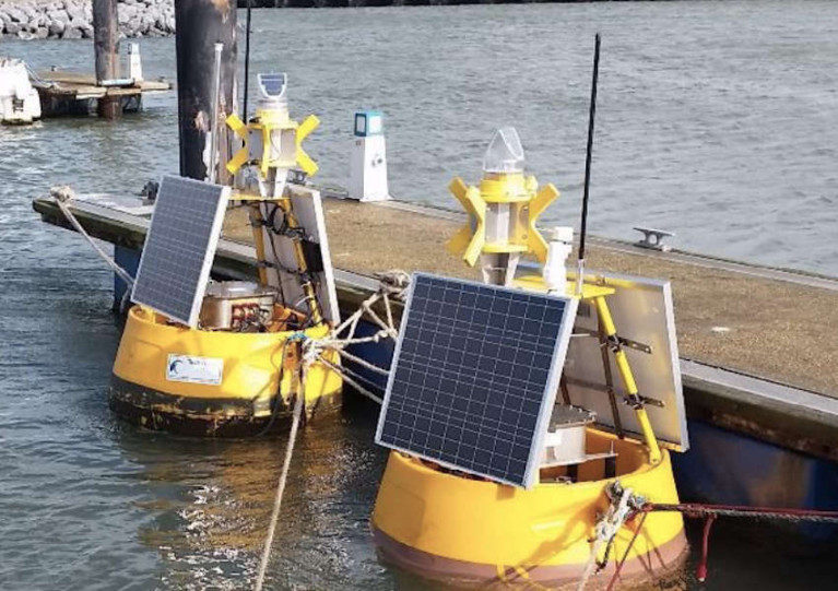
The buoy will be a yellow DB 500 and have a flashing light sequence of five flashes every 20 seconds, with a range of three nautical miles. The buoy will be marked with a St Andrew’s sross and radar reflector.

The wave buoy will be deployed at 53° 2' 35” N, -5° 41' 17” W by the the AMS Retriever (Callsign MEHI8) with an AIS system on board which has a provisional callsign of CWPW01.

If the deployment is delayed due to the weather, it will be carried out on the next viable tide and weather window. Once deployed, the wave buoy will remain on site for a minimum of six months.

Further details can be found in Marine Notice No 57 of 2020, a PDF of which is available to download below.

Published in Marine Warning

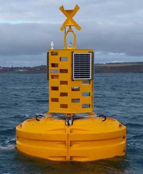
TechWorks Marine has deployed an operational Wave Buoy by Port of Cork in late 2016, to be deployed at Roche’s Point on the approach to Cork Harbour.

As the Wave climate in Ireland takes its toll on equipment, a large platform was recommended in order to survive the heavy weather, and maximise visibility of the data buoy to the shipping activity using the harbour on a daily basis.

Central to this development is the TechWorks Marine TMBB-Data Acquisition and Transmission system, the versatile and configurable monitoring platform is designed around it. The TMBB is a robust, reliable and scalable data acquisition system, which ensures the ongoing collection and transmission of quality assured data to enable clients to make informed decisions linked to their commercial activity. Already operational, data is being transmitted in real-time every 20 minutes to the Port of Cork Operations station. The inertial wave sensor used on the buoy is the SeaView Systems SVS-603. The Mobilis Jet9000 buoy Hull was selected as the most robust and reliable platform for such long term operational deployment.

The engineering team at TechWorks Marine carried out the full system integration and testing and extensive onsite training was provided, combined with detailed hardware and software documentation. The TechWorks Marine Data buoy can be easily upgraded in the future with additional Meteorological and Oceanographic sensors given the modular structure of the TMBB system.

Ms Charlotte O’Kelly, CEO of TechWorks Marine confirmed that the Wave buoy was deployed operationally in early December following initial on-site testing by TechWorks Marine. Ms O'Kelly said: ‘At present, the data buoy reports directly to the Port of Cork operations centre from where its data is used to ensure the safety of ships coming in and out of the Harbour.’

Port of Cork Harbour Master, Captain Paul O Regan commented on the wave buoy saying: ‘To date the wave data we have collected has been extremely useful with regards to our shipping operations. Safety is our first priority at the Port of Cork and this technology will assist us as we see larger vessels arriving into the port.’

Published in Cork Harbour

Marine Protected Areas (MPAs) - FAQS

Marine protected areas (MPAs) are geographically defined maritime areas where human activities are managed to protect important natural or cultural resources. In addition to conserving marine species and habitats, MPAs can support maritime economic activity and reduce the effects of climate change and ocean acidification.

MPAs can be found across a range of marine habitats, from the open ocean to coastal areas, intertidal zones, bays and estuaries. Marine protected areas are defined areas where human activities are managed to protect important natural or cultural resources.

The world's first MPA is said to have been the Fort Jefferson National Monument in Florida, North America, which covered 18,850 hectares of sea and 35 hectares of coastal land. This location was designated in 1935, but the main drive for MPAs came much later. The current global movement can be traced to the first World Congress on National Parks in 1962, and initiation in 1976 of a process to deliver exclusive rights to sovereign states over waters up to 200 nautical miles out then began to provide new focus

The Rio ‘Earth Summit’ on climate change in 1992 saw a global MPA area target of 10% by the 2010 deadline. When this was not met, an “Aichi target 11” was set requiring 10% coverage by 2020. There has been repeated efforts since then to tighten up MPA requirements.

Marae Moana is a multiple-use marine protected area created on July 13th 2017 by the government of the Cook islands in the south Pacific, north- east of New Zealand. The area extends across over 1.9 million square kilometres. However, In September 2019, Jacqueline Evans, a prominent marine biologist and Goldman environmental award winner who was openly critical of the government's plans for seabed mining, was replaced as director of the park by the Cook Islands prime minister’s office. The move attracted local media criticism, as Evans was responsible for developing the Marae Moana policy and the Marae Moana Act, She had worked on raising funding for the park, expanding policy and regulations and developing a plan that designates permitted areas for industrial activities.

Criteria for identifying and selecting MPAs depends on the overall objective or direction of the programme identified by the coastal state. For example, if the objective is to safeguard ecological habitats, the criteria will emphasise habitat diversity and the unique nature of the particular area.

Permanence of MPAs can vary internationally. Some are established under legislative action or under a different regulatory mechanism to exist permanently into the future. Others are intended to last only a few months or years.

Yes, Ireland has MPA cover in about 2.13 per cent of our waters. Although much of Ireland’s marine environment is regarded as in “generally good condition”, according to an expert group report for Government published in January 2021, it says that biodiversity loss and ecosystem degradation are of “wide concern due to increasing pressures such as overexploitation, habitat loss, pollution, and climate change”.

The Government has set a target of 30 per cent MPA coverage by 2030, and moves are already being made in that direction. However, environmentalists are dubious, pointing out that a previous target of ten per cent by 2020 was not met.

Conservation and sustainable management of the marine environment has been mandated by a number of international agreements and legal obligations, as an expert group report to government has pointed out. There are specific requirements for area-based protection in the EU Marine Strategy Framework Directive (MSFD), the OSPAR Convention, the UN Convention on Biological Diversity and the UN Sustainable Development Goals. 

Yes, the Marine Strategy Framework directive (2008/56/EC) required member states to put measures in place to achieve or maintain good environmental status in their waters by 2020. Under the directive a coherent and representative network of MPAs had to be created by 2016.

Ireland was about halfway up the EU table in designating protected areas under existing habitats and bird directives in a comparison published by the European Commission in 2009. However, the Fair Seas campaign, an environmental coalition formed in 2022, points out that Ireland is “lagging behind “ even our closest neighbours, such as Scotland which has 37 per cent. The Fair Seas campaign wants at least 10 per cent of Irish waters to be designated as “fully protected” by 2025, and “at least” 30 per cent by 2030.

Nearly a quarter of Britain’s territorial waters are covered by MPAs, set up to protect vital ecosystems and species. However, a conservation NGO, Oceana, said that analysis of fishing vessel tracking data published in The Guardian in October 2020 found that more than 97% of British MPAs created to safeguard ocean habitats, are being dredged and bottom trawled. 

There’s the rub. Currently, there is no definition of an MPA in Irish law, and environment protections under the Wildlife Acts only apply to the foreshore.

Current protection in marine areas beyond 12 nautical miles is limited to measures taken under the EU Birds and Habitats Directives or the OSPAR Convention. This means that habitats and species that are not listed in the EU Directives, but which may be locally, nationally or internationally important, cannot currently be afforded the necessary protection

Yes. In late March 2022, Minister for Housing Darragh O’Brien said that the Government had begun developing “stand-alone legislation” to enable identification, designation and management of MPAs to meet Ireland’s national and international commitments.

Yes. Environmental groups are not happy, as they have pointed out that legislation on marine planning took precedence over legislation on MPAs, due to the push to develop offshore renewable energy.

No, but some activities may be banned or restricted. Extraction is the main activity affected as in oil and gas activities; mining; dumping; and bottom trawling

The Government’s expert group report noted that MPA designations are likely to have the greatest influence on the “capture fisheries, marine tourism and aquaculture sectors”. It said research suggests that the net impacts on fisheries could ultimately be either positive or negative and will depend on the type of fishery involved and a wide array of other factors.

The same report noted that marine tourism and recreation sector can substantially benefit from MPA designation. However, it said that the “magnitude of the benefits” will depend to a large extent on the location of the MPA sites within the network and the management measures put in place.

© Afloat 2022