Menu

Ireland's sailing, boating & maritime magazine

A Harbour Seal photographed at Dun Laoghaire Marina on Dublin Bay, Ireland. Also known as the common seal, is a true seal found along temperate and Arctic marine coastlines of the Northern Hemisphere. The most widely distributed species of pinnipeds, they are found in coastal waters of the northern Atlantic and Pacific oceans, Baltic and North seas. Photo: AfloatA photograph of a Harbour Seal taken at Dun Laoghaire Marina on Dublin Bay, Ireland. Also known as the common seal, this species can be found along temperate and Arctic marine coastlines throughout the Northern Hemisphere. They are the most widely distributed species of pinnipeds and can be found in the coastal waters of the northern Atlantic and Pacific oceans, as well as the Baltic and North Seas. Photo: Afloat

Displaying items by tag: GLA

All three General Lighthouse Authorities (GLA) of the UK and Ireland - Trinity House, the Northern Lighthouse Board and Irish Lights - will discontinue their Differential GPS (DGPS) service in March 2022.

The GLAs made this decision after carefully considering the results from an extensive consultation carried out with stakeholders and service users. They will cease transmission of the signal after 31 March 2022.

It was in 1995 that the GLAs introduced DGPS as part of the mix of marine aids to navigation (AtoN) provided to safeguard mariners within their combined waters and to help protect the environment. The system became fully operational in 1997. The system consists of 14 DGPS reference stations, six far-field monitoring sites and three monitoring and control sites. The system is operated as a single AtoN, operated and maintained by the three GLAs.

Dr Alan Grant, GLA DGPS System Director, said: “After careful consideration of the results of the consultation process, the three GLAs have concluded that their DGPS system is now redundant. Today’s GNSS are able to meet all but the most stringent accuracy requirements, and position integrity can be provided by alternative means (RAIM or other visual and electronic aids to navigation).

“The GLAs recognise the need to provide adequate notice and support continuity of service going forward. As such, the DGPS system will remain operational until 31 March 2022, at which point the signals will cease.”

Background

Marine radiobeacon DGPS was developed by the GLAs to counter Selective Availability (SA), a deliberate error added to the civilian GPS service to degrade its positional accuracy. The DGPS correction to the position error meant an improvement in accuracy from approximately 50m to around 5m.

In addition to improving the estimated position accuracy, by assessing whether the error is within a given threshold, the reference station is able to monitor the performance of the GPS constellation and identify any faults. Faulty satellites are removed from the position solution, providing position integrity for the mariner.

SA was discontinued in 2000 and GPS now offers the civilian user a position accurate to around 3-5m. DGPS still improves positional accuracy - now enabling positions in the region of 1-2m - but it is the position integrity function that is most often cited as the main benefit of DGPS.

While marine radiobeacon DGPS is not mandated by the International Maritime Organization for carriage on SOLAS vessels, it is provided for in all maritime receiver standards and the spectrum is allocated internationally.

Consultation 

The infrastructure required to run the service is approaching the end of its design life; the GLAs conducted a stakeholder consultation to assess the requirements for the service going forward, surveying and interviewing stakeholders from across the maritime sector and beyond.

Of the responses received, 86% were from mariners and maritime operators, operating a wide range of vessels including ferries, container ships, tankers, liquid natural gas carriers, bulk carriers and leisure craft.

The survey resulted in a mix of responses, with the majority of mariners reporting that they use the DGPS system for accuracy improvements and integrity, while others reported that they do not use it.

All mariners reported using GPS today with around 40% also making use of GLONASS, and around 9% using Galileo too. From the response received, it is expected that more mariners will move to multi-constellation receivers, making use of GPS, GLONASS, Galileo and BeiDou over the next five to ten years.

Maritime Safety 

Following a change in maritime receiver standards in 2003, all receivers now include Receiver Autonomous Integrity Monitoring (RAIM). RAIM is a means of determining whether the resulting position estimate is safe to use through an algorithm within the receiver.

Differential corrections are also available from other sources, including Satellite Based Augmentation Systems (SBAS), which are primarily provided for aviation users. Work is under way in Europe to introduce a maritime service to EGNOS, the European SBAS. This service is expected to be available around 2022.

Vessels that need high accuracy position and integrity for operations mainly utilise a number of commercial satellite-based services; the decision to discontinue DGPS has no operational impact on these services.

The GLAs advise mariners to consider their use of DGPS and to plan for its discontinuance accordingly. Mariners should check their GNSS receiver(s) to confirm the presence of RAIM and consider upgrading to type-approved SBAS receiving equipment when available.

The GLAs encourage mariners to use all available AtoN - whether visual or electronic - to support their safe passage and the protection of the environment.

To download a PDF copy of the full DGPS article by Dr Alan Grant click here

Published in Lighthouses

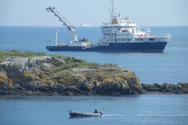
Sailing was not the only activity that took place in Dublin Bay last Saturday as the Northern Lighthouse Board's (NLB) multi-function tender NLV Pharos was busy at work, writes Jehan Ashmore.

The NLB is the Scottish equivalent of the Commissioners of Irish Lights (CIL) and it is not unusual for such vessels to share work duties beyond their respective jurisdictions. The 84m NLV Pharos is equipped with dynamic positioning and a 30-tonne main crane on her 300m2 aft-deck.

Overall she is similar in appearance to Irish lights ILV Granuaile which is based out of Dun Laoghaire. The Irish Lights tender built in Romania in 2000 tends to operate more often off the west coast during the summer months due to the more favourable weather conditions.

The 1,300 (dwt) deadweight tonnes NLV Pharos yesterday returned to her base in Oban from her Irish duties. The west coast base was established in 1904 and is also homeport to the service's smaller NLV Pole Star which is equipped with an 18-tonne crane on her 90m2 aft deck.

The facility in 2000 underwent a £4.2 million redevelopment to turn a buoy yard into a multi functional support base which is computer-linked to the NLB headquarters in Edinburgh.

In addition Trinity House which maintains the service for England and Wales operate the tenders THV Galtea,THV Patricia and the fast-response craft THV Alert from their base in Harwich.

Trinity House forms the trio of the General Lighthouse Authorities (GLA) alongside NLB and CIL. Each member of the GLA co-operate in the allocation of vessel-tender deployment.

Asides the varied and critical role of the tasks performed by the GLA's tenders, they are also available for charter to third parties. Between them the tenders can conduct buoy and chain work, search and rescue, lighthouse re-fuelling, salvage and recovery, towing, hydrographic applications and ROV work.

Published in Lighthouses
Britain is to stop paying towards the cost of funding the Commissioners of Irish Lights (CIL) according to a report in Lloyds List. In an agreement reached between London and Dublin, a formal announcement on the timetable for removing the subsidy is expected shortly.
The Irish Government has agreed to pay for its own lighthouses, buoys and other marine aids to navigation. The UK subsidy is likely to be eliminated during the current parliament if all goes according to plan. That is the pledge made by Mr Penning, UK Minister of Shipping on several occasions in recent months. The phase-out will start in the next financial year.

The total cost of providing these services comes to around £75m ($116.5m) a year, of which Irish Lights accounts for €32m. The UK subsidy to Ireland is between £10m and £12m, with the Irish government contributing some £6m and the balance coming from fees.

All three general lighthouse authorities (GLA) are working on ways to cut costs and improve efficiencies, with a joint strategic board set up to consider how they can work together more effectively.

Published in Lighthouses

For all you need on the Marine Environment - covering the latest news and updates on marine science and wildlife, weather and climate, power from the sea and Ireland's coastal regions and communities - the place to be is Afloat.ie.

Coastal Notes

The Coastal Notes category covers a broad range of stories, events and developments that have an impact on Ireland's coastal regions and communities, whose lives and livelihoods are directly linked with the sea and Ireland's coastal waters.

Topics covered in Coastal Notes can be as varied as the rare finding of sea-life creatures, an historic shipwreck with secrets to tell, or even a trawler's net caught hauling much more than just fish.

Other angles focusing the attention of Coastal Notes are Ireland's maritime museums, which are of national importance to maintaining access and knowledge of our nautical heritage, and those who harvest the sea using small boats based in harbours where infrastructure and safety pose an issue, plying their trade along the rugged wild western seaboard.

Coastal Notes tells the stories that are arguably as varied as the environment they come from, and which shape people's interaction with the natural world and our relationship with the sea.

Marine Wildlife

One of the greatest memories of any day spent boating around the Irish coast is an encounter with Marine Wildlife. It's a thrill for young and old to witness seabirds, seals, dolphins and whales right there in their own habitat. And as boaters fortunate enough to have experienced it will testify, even spotting a distant dorsal fin can be the highlight of any day afloat. Was that a porpoise? Was it a whale? No matter how brief the glimpse, it's a privilege to share the seas with Irish marine wildlife.

Thanks to our location in the North Atlantic, there appears to be no shortage of marine life to observe. From whales to dolphins, seals, sharks and other ocean animals, the Marine Wildlife category documents the most interesting accounts around our shores. And we're keen to receive your observations, your photos, links and video clips, too!

Also valuable is the unique perspective of all those who go afloat, from coastal sailing to sea angling to inshore kayaking to offshore yacht racing, as what they encounter can be of great importance to organisations such as the Irish Whale and Dolphin Group (IWDG). Thanks to their work we now know we share the seas with dozens of species who also call Ireland home. But as impressive as the list is, the experts believe there are still gaps in our knowledge. Next time you are out on the ocean waves, keep a sharp look out!

Weather

As an island in the North Atlantic, Ireland's fate is decided by Weather more so than many other European countries. When storm-force winds race across the Irish Sea, ferry and shipping services are cut off, disrupting our economy. When swollen waves crash on our shores, communities are flooded and fishermen brace for impact - both to their vessels and to their livelihoods.

Keeping abreast of the weather, therefore, is as important to leisure cruisers and fishing crews alike - for whom a small craft warning can mean the difference between life and death - as it is to the communities lining the coast, where timely weather alerts can help protect homes and lives.

Weather affects us all, and Afloat.ie will keep you informed on the hows and the whys.

Marine Science

Perhaps it's the work of the Irish research vessels RV Celtic Explorer and RV Celtic Voyager out in the Atlantic Ocean that best highlights the essential nature of Marine Science for the future growth of Ireland's emerging 'blue economy'.

From marine research to development and sustainable management, Ireland is developing a strong and well-deserved reputation as an emerging centre of excellence. Whether it's Wavebob ocean energy technology to aquaculture to weather buoys and oil exploration, the Marine Science category documents the work of Irish marine scientists and researchers and how they have secured prominent roles in many European and international marine science bodies.

Power From The Sea

The message from the experts is clear: offshore wind and wave energy is the future. And as Ireland looks towards the potential of the renewable energy sector, generating Power From The Sea will become a greater priority in the State's 'blue growth' strategy.

Developments and activities in existing and planned projects in the pipeline from the wind and wave renewables sector, and those of the energy exploration industry, point to the future of energy requirements for the whole world, not just in Ireland. And that's not to mention the supplementary industries that sea power projects can support in coastal communities.

Irish ports are already in a good position to capitalise on investments in offshore renewable energy services. And Power From The Sea can even be good for marine wildlife if done properly.

Aside from the green sector, our coastal waters also hold a wealth of oil and gas resources that numerous prospectors are hoping to exploit, even if people in coastal and island areas are as yet unsure of the potential benefits or pitfalls for their communities.

Changing Ocean Climate

Our ocean and climate are inextricably linked - the ocean plays a crucial role in the global climate system in a number of ways. These include absorbing excess heat from the atmosphere and absorbing 30 per cent of the carbon dioxide added to the atmosphere by human activity. But our marine ecosystems are coming under increasing pressure due to climate change.

The Marine Institute, with its national and international partners, works to observe and understand how our ocean is changing and analyses, models and projects the impacts of our changing oceans. Advice and forecasting projections of our changing oceans and climate are essential to create effective policies and management decisions to safeguard our ocean.

Dr Paul Connolly, CEO of the Marine Institute, said, “Our ocean is fundamental to life on earth and affects so many facets of our everyday activities. One of the greatest challenges we face as a society is that of our changing climate. The strong international collaborations that the Marine Institute has built up over decades facilitates a shared focusing on our changing ocean climate and developing new and enhanced ways of monitoring it and tracking changes over time.

“Our knowledge and services help us to observe these patterns of change and identify the steps to safeguard our marine ecosystems for future generations.”

The Marine Institute’s annual ocean climate research survey, which has been running since 2004, facilitates long term monitoring of the deep water environment to the west of Ireland. This repeat survey, which takes place on board RV Celtic Explorer, enables scientists to establish baseline oceanic conditions in Irish waters that can be used as a benchmark for future changes.

Scientists collect data on temperature, salinity, water currents, oxygen and carbon dioxide in the Atlantic Ocean. This high quality oceanographic data contributes to the Atlantic Ocean Observing System. Physical oceanographic data from the survey is submitted to the International Council for the Exploration of the Seas (ICES) and, in addition, the survey contributes to national research such as the VOCAB ocean acidification and biogeochemistry project, the ‘Clean Atlantic’ project on marine litter and the A4 marine climate change project.

Dr Caroline Cusack, who co-ordinates scientific activities on board the RV Celtic Explorer for the annual survey, said, “The generation of long-term series to monitor ocean climate is vital to allow us understand the likely impact of future changes in ocean climate on ecosystems and other marine resources.”

Other activities during the survey in 2019 included the deployment of oceanographic gliders, two Argo floats (Ireland’s contribution to EuroArgo) and four surface drifters (Interreg Atlantic Area Clean Atlantic project). The new Argo floats have the capacity to measure dissolved ocean and biogeochemical parameters from the ocean surface down to a depth of 2,000 metres continuously for up to four years, providing important information as to the health of our oceans.

During the 2019 survey, the RV Celtic Explorer retrieved a string of oceanographic sensors from the deep ocean at an adjacent subsurface moored station and deployed a replacement M6 weather buoy, as part of the Irish Marine Data Buoy Observation Network (IMDBON).

Funded by the Department of Agriculture, Food and the Marine, the IMDBON is managed by the Marine Institute in collaboration with Met Éireann and is designed to improve weather forecasts and safety at sea around Ireland. The data buoys have instruments which collect weather and ocean data including wind speed and direction, pressure, air and sea surface temperature and wave statistics. This data provides vital information for weather forecasts, shipping bulletins, gale and swell warnings as well as data for general public information and research.

“It is only in the last 20 years, meteorologists and climatologists have really began to understood the pivotal role the ocean plays in determining our climate and weather,” said Evelyn Cusack, Head of Forecasting at Met Éireann. “The real-time information provided by the Irish data buoy network is particularly important for our mariners and rescue services. The M6 data buoy in the Atlantic provides vital information on swell waves generated by Atlantic storms. Even though the weather and winds may be calm around our shores, there could be some very high swells coming in from Atlantic storms.”