


Displaying items by tag: Howth Harbour
Marine Minister Officially Names New €10m ‘Fishing Pier’ at Howth Fishery Harbour Centre
Marine Minister Charlie McConalogue today (Thursday 2 March) officially named the new €10m ‘Fishing Pier’ at Howth Fishery Harbour Centre, one of the six State-owned Fishery Harbour Centres.
The works comprised the construction of 134 metres of new quay wall, dredging, stabilisation and infill of subsea material which covers a greatly enlarged area of 6,500 sqm.
The additional berthing space created relieves vessel congestion issues and enables greater segregation between the activities of fishing vessels and the marine tourism and leisure activities which are mainly concentrated on the West Pier.
Works on the site commenced in October 2020 and were completed in April 2022 at a cost of €10 million.
 Howth's new fishing pier - The works comprised the construction of 134 metres of new quay wall, dredging, stabilisation and infill of subsea material which covers a greatly enlarged area
This major redevelopment project was funded through the Department of Agriculture, Food and the Marine’s Fishery Harbour and Coastal Infrastructure Development Programme.
Officially opening ‘The Fishing Pier’, the minister said: “It is an integral part of my department’s overall strategy to provide dedicated, stand-alone fit for purpose facilities for the fishing industry in Howth.
“The newly redeveloped ‘Fishing Pier’ facilitated the moving of vessels from the West Pier onto this redeveloped pier. I must also acknowledge our main contractor, John Sisk, and consulting engineer Malachy Walsh and Partners who overcame COVID-19 restrictions and supply chain delays to deliver a first-class structure.”
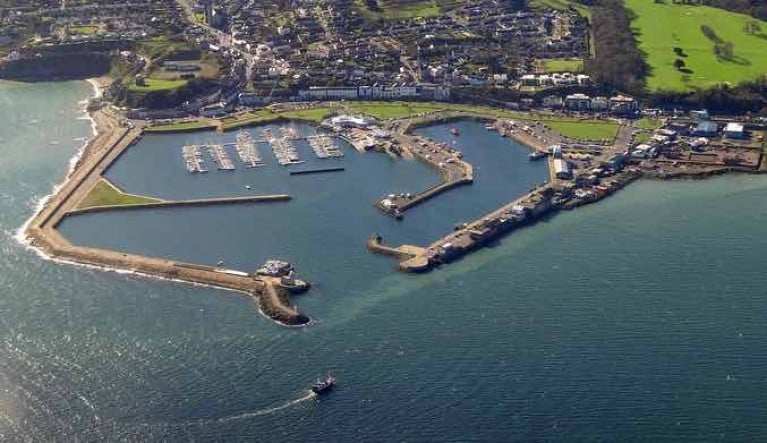
 Bird’s eye view of the new Fishing Pier at Howth
In 2021, almost 90% of all fish landed into Ireland was into the six State-owned Fishery Harbour Centres. At Howth, these landings were valued at c.€12.9 million.
Minister McConalogue noted: “The six Fishery Harbour Centres are critical infrastructure for our seafood industry. By attracting increased fish landings, we will deliver the raw materials to drive and maximise the opportunities for primary and secondary processing and ensure a strong Irish seafood processing industry. The importance of these primary and secondary food production activities is reflected in the Government’s Food Vision 2030 policy“.
 The new pier adds extensive and much-needed quay space of 6,500m2 in a seasonally very busy harbour
HOWTH DREDGING PLANS
The Department of Agriculture, Food and the Marine says it has plans for further significant investment with a dredging and reclamation project for Howth Fishery Harbour Centre and planning permission for this project is currently under consideration by An Bord Pleanála.
After unveiling the plaque, Minister McConalogue said: “In addition to the fisheries and seafood production industries, the Fishery Harbour Centres are accommodating an ever-increasing amount of diverse marine commercial business, including commercial cargo traffic, cruise liners, restaurants and other leisure, tourism, and social activities.
“All of these activities complement the critical economic activity generated by our fishing industry and help to maintain the vitality of these coastal communities.”
The Department of Agriculture, Food and the Marine invites suitably qualified contractors to submit a tender package to construct up to two reinforced concrete boatyard repair bays within the existing DAFM Boatyard located on the West Pier of Howth Fishery Harbour Centre.
The repair bays will be around 500 sqm each, with works to include surfacing, installation of draining pipework, gullies and manholes (of a depth not greater than 2m) and more.
The successful contractor will also be expected to excavate and dispose of existing life-expired asphalt surfacing off-site at a licensed facility.
This tender award is expected in late May or early June with works to commence in June or July, and is awarded subject to available funding.
The RFT is in one lot and can be viewed on the eTenders website under reference 210774. The deadline for responses to this tender is noon on Wednesday 4 May.
Upgrade Works on Howth Harbour’s Arsenal Building Open for Tender
The Department of Agriculture, Food and the Marine is inviting tenders from suitably qualified contractors to carry out various upgrade works on the Arsenal Building on Howth Harbour’s West Pier.
The building currently serves as the fishermen’s toilet and shower unit at Howth Fishery Harbour Centre in north Co Dublin.
Works required include roofing, stonework cleaning and pointing as well as general repairs and upgrades such as installing new doors and windows.
Tenders are to be submitted in one lot. The request for tender (RFT) is in a single lots and can be viewed on the eTenders website under reference 196560.
Reduced Depths at the Entrance to Howth Harbour & Marina
A new Notice to Mariners (2562/21) provides information on reduced depths at the entrance to Howth Harbour and Marina and was issued today (14/06/2021) by the UK Hydrographic Office.
The notice was circulated by Harbour Master Harold McLoughlin at the Howth Fishery Harbour Centre.
Download the full notices below as PDF files
 Reduced depths at the entrance to Howth Harbour and Marina
The Department of Agriculture, Food and the Marine is seeking tenders for the resurfacing of repair bays within its boatyard at Howth Fishery Harbour Centre in North Co Dublin.
The request for tender is divided into two lots and calls for the upgrade of the existing 520 sqm work bays at the West Pier of Howth Harbour with new drainage and a reinforced concrete surface.
The first lot is to be awarded to a suitable contractor for construction in summer 2021. A second lot may be awarded subject to available funding for works later this year or early 2022.
For more details on the tender see the eTenders website HERE.
Howth Harbour's Convoluted Origins to Be Revealed
Dublin Bay Old Gaffers Association invites you to join their next Zoom session, which will be on The Building of Howth Harbour and presented by Rob Goodbody on Thursday, 8th April at 20:00hrs.
The present Howth Harbour celebrated its Bicentenary last year. Rob Goodbody will explain how the small harbour at Howth, which had existed for centuries primarily for small fishing boats, underwent huge development during the early decades of the Nineteenth Century following the Act of Union, and the transfer of power from Dublin to London.
Howth Harbour became the mail packet station for the Dublin-London route. But with the advent of larger steamships, the harbour became too small and the mails were transferred to the newer larger harbour at Kingstown, leaving Howth to revert back to a fishing port.
Rob Goodbody trained in geography, planning and building conservation, and has a great interest in local history and industrial heritage. He worked as a planner for local authorities in London and Dublin from 1974 to 2003. Since then, Rob has specialised in historic building conservation and has published a number of books, including The Metals - from Dalkey to Dun Laoghaire about the construction of Dun Laoghaire Harbour, and he also co-authored Dublin Bay - Nature & History.
Please come early to be sure of getting a good seat.
DBOGA Fundraising for HOWTH RNLI: Pre-Covid, listened to talks together at Poolbeg while passing the Yellow Welly around for a €5 donation. In Zoom Land we can't do that but the RNLI urgently needs funds.
Please click on: www.justgiving.com/fundraising/DBOGAHowthLifeboat to contribute your €5. DBOGA are well on the way to our target of €4,000. Thank you!
The details of this Zoom meeting are:
Topic: Rob GoodbodyTalk • Time: April 8th 2021, at 20.00hrs
Link to join the meeting: https://us02web.zoom.us/j/85300865136
Meeting ID: 853 0086 5136
 Howth Harbour today – among many changes, the sunshine allocation has been significantly increased
The Department of Agriculture, Food and the Marine (DAFM), the harbour authority for Howth Harbour Fishery Centre in North County Dublin, is proposing to dredge seabed material from within the harbour to provide better water access to the fishing, leisure, and RNLI craft using the harbour.
Silting of the harbour and the subsequent dredging conversation has been an ever-present challenge for the harbour over the past two decades.
It is proposed to reuse the material to create an area for the public realm on the west side of the West Pier.
The volume of material to be removed is approximately 240,000m3, and the area to be created is approximately 4.8ha.
The reclaimed area would be used for public realm, water access for leisure users, car parking and hard standing areas that can be used for storage areas for existing harbour leisure users and the harbour authority. In the future, some of the area created may be converted to light industrial/ commercial use to support harbour operations. Such future use is not part of the proposed development being considered at present.
 Howth Harbour in North County Dublin
The harbour was upgraded in the 1980s when the Syncrolift, the berthage face along the west pier, the present middle pier, the internal breakwater, and the marina area were constructed.
Enhancement of water depths within the harbour area is now required to maintain safe access to the harbour during any tide state. This is necessary because of increased fishing vessel sizes, siltation, and a desire to improve the usable water area. Lack of sufficient water depths due to siltation in the vicinity of the public and RNLI slipways is resulting in restricted access to the water for the public and RNLI rescue craft at low tide.
To this end, the DAFM are preparing a planning application, EIAR and NIS for a proposed dredging and reclamation project at Howth Harbour FHC.
While a town hall public consultation exercise would normally be undertaken to inform the preparation of a planning application with an EIAR, because of COVID restrictions, this public consultation exercise is being undertaken virtually.
 Details of the West Pier's proposed design, utilising the spoil from the dredging
Proposed Howth Harbour Development
The proposed development will be the subject of a planning application by the Department of Agriculture, Food and the Marine and relates to the following main elements:
- Dredging of the harbour and reclamation of land on the west side of the West Pier using treated dredge material;
- The dredge material will be treated using soil stabilisation techniques prior to placement in the reclamation area. This will improve the strength of soil, bind in contaminants and minimise the potential for leachate;
- Coastal protection works to the perimeter of the reclaimed area;
- Landscaping on the reclaimed area and construction of footways, roadways and parking areas;
- Construction of viewing points and a slipway for access to the water;
- Construction of storage areas for harbour activities;
- Provision of necessary services.
If you would like to submit your comments or feedback, you can do so at:
Comments must be submitted before 2300hrs (11pm) Friday 09 April 2021
Download the full proposal below (7mb)
Howth Harbour Gets Sisk the Builders In
"Getting the builders in" is a challenging prospect on land at the best of times. Add in the sea, and it's then a challenge-plus. Thus when you're working on and in the waterfront to implement a project within a busy fishing/sailing harbour which has found itself becoming something of a cult tourism magnet, the problems are magnified tenfold for contractors and harbour users alike.
Certainly, this is the prospect at Howth, where this week Sisk the Builders will be starting to move in to set up a new operational site on the Middle Pier. This will – in just 13 months, it is hoped - provide a completely new 135 metres of proper quay wall along the currently rock-armoured west side of the Middle Pier, with dredged material from the new "long berth" being deposited in a revetment-retained infill on the Middle Pier's East Side, thereby providing much-needed extra shore space for vehicles serving the boats using the new berths.
Part of Howth's attraction for visitors is the colourful but often very crowded scene along the main fishing boat area on the West Pier. It's entertaining to be feasting off seafood at one of the many characterful restaurants along the pier, as forklifts with fishing gear go buzzing closely past. And every so often, a seemingly enormous fishing boat makes her stately way across the quay in slow style on the Syncrolift trolleys to receive the attentions of Johnny Leonard and his skilled staff in the shipyard. There's never a dull moment. But there are times when it's all just too much of a good thing. A safety valve of alternative berthing and extra shoreside space was becoming urgently needed.
 Howth's Fish Dock may provide a colourful setting for a quayside array of characterful seafood restaurants along the West Pier, but extra berthing space is urgently needed. Photo: W M Nixon
Down along the west side of the Middle Pier was the only option. This would be simple enough if everyone was game to close off substantial parts of the harbour to let the contractors have a free run at the job. But it says everything about the spirit of Howth that this doesn't seem to have occurred to anyone. From the beginning, the assumption was that virtually all of the harbour's activities could continue with as little interruption as possible, and Harbour Master Harry McLoughlin and Howth Yacht Cub Commodore Ian Byrne, together with representatives of other interests, set themselves the task of facilitating the contractors while keeping the floating show on the road.
As Ian Byrne became our "Sailor of the Month" back in May for deciphering the multiple rules for exiting the first Covid lockdown in a way which was comprehensible to all sailors, he was ideal to speak for the consumers, while Harry McLoughlin - a widely-experienced harbour master who has a real vision for Howth - ably filled the role as the human face of officialdom. Between themselves and the contractors, they worked out a viable scheme despite having to include extra elements made necessary by the space requirements of COVID-19
 Site plan showing (red line) the agreed limits of the boundary of the works. This will enable much of the harbour – including the public slipway beside the Lifeboat Station – to continue to function, but inevitably there will be some reduction in car parking spaces.
Of course, those who know Howth well appreciate that while this new project will – if all goes according to plan - give the fishing fleet a very welcome and useful Christmas present at the end of 2021, it is just the beginning of a process in which the long-overdue dredging of the harbour – more needed in some parts then in others – is steadily moving up the agenda.
But if this scheme goes according to plan in a spirit of harmony, it will, in turn, create the atmosphere in which other mutually beneficial works can be undertaken with an attitude of realism and a mood of mutual respect. And if by some happy chance the pandemic subsides and visitors are allowed back to Howth in their previous numbers next Spring, well, the fact that there's an interesting bit of maritime contracting work underway will give them something extra to look at, for the main attraction of Howth Harbour seems to be that people on holiday enjoy nothing more than watching other people doing unusual work…
 By the beginning of November (COVID permitting) this end section of Howth's Middle Pier will be a hive of activity with the rock armour on the Fish Dockside being converted into a quay wall.
Howth Harbour Dredging Plans Move Forward With New Details
The Department of Agriculture, Food and the Marine has updated local Fingal councillors on its proposals for the dredging of Howth Harbour.
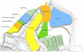
On his Facebook page, Cllr Cian O’Callaghan says the meeting with the department and the Howth Harbour Master on Wednesday (6 March) detailed a plan to dredge five key areas of the harbour, namely:
- The fishing trawler basin between the West Pier and Middle Pier
- The approach channel at the mouth of the harbour
- The marina used by Howth Yacht Club
- The approach channel to the marina
- The outer moorings area which is used by the Howth Sailing and Boat Club
This would result in the extraction of 225,000 cubic metres of silt, the equivalent of up to 30,000 lorry loads, says Cllr O’Callaghan.
The detailed plan follows testing of material extracted from the harbour which confirms that while is it contaminated by general harbour activity, it is not considered hazardous.
It is being proposed that the spoil be treated and used to create a 100-metre-wide infill area along the west side of the present West Pier. Plans for the use of this new space have not yet been decided but it is expected there will be a relevant public consultation by year’s end.
Four months ago the tender period closed for engineering services related to these long-awaited dreading works in the North Co Dublin harbour.
Detention By Navy of Fishing Vessels In Irish Sea
#NavalService - Fishing boats, both Irish-registered have been detained in the Irish Sea for alleged breaches of fishing rules.
It was part of an overnight operation The Irish Examiner writes by the Naval Service patrol vessel LE Eithne when officers boarded the two boats.
The vessels are being escorted to Howth Harbour in Co.Dublin and will then be handed over to Gardaí.
It brings to seven the number of boats detained by the Naval Service so far this year.


 as lead helm, rounds the Fastnet Rock on the way to the overall win in 1987")


