Menu

Ireland's sailing, boating & maritime magazine

Inland afloat headers


Displaying items by tag: Greenway

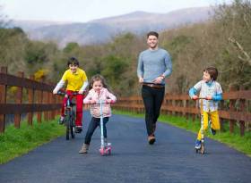
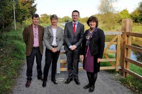
The Royal Canal Greenway, a scenic 130km walking and cycling amenity stretching alongside the historic 225-year-old canal, officially launches today ahead of the summer 2021 season. The €12 million project co-ordinated by Waterways Ireland is the country’s longest Greenway, traversing through Kildare, Meath, Westmeath and Longford. Those wishing to experience the Royal Canal Greenway are advised to adhere to Government guidelines on movement and social distancing.

The newest outdoor adventure tourism attraction for the country, the Royal Canal Greenway is a former towpath for barges featuring 90 bridges, 33 locks, 17 harbours and four aqueducts. Greenway users can choose to complete the entire 130km flat, off-road trail in one visit or explore the shorter designated routes — ranging from 6km to 15km — between the 14 connecting access points and towns.

Longford Bridge, Ballymahon in County Longford on the Royal Canal GreenwayLongford Bridge, Ballymahon in County Longford on the Royal Canal Greenway

High-profile attractions linking onto the Royal Canal Greenway are trails to Carton House in Maynooth; Corlea Trackway Visitor Centre — one of the largest prehistoric roads in Europe — in Longford; and Center Parcs. The 165km self-guided National Famine Way also travels largely along the Greenway, following the footsteps of 1,490 emigrants who walked from Roscommon to Dublin at the peak of the famine in 1847.

Speaking on the official Greenway opening, Minister for Transport, Eamon Ryan TD said: “We are delighted to launch the Royal Canal Greenway, a game changer for outdoor tourism, and leisure in Ireland and part of a growing network of greenways we will fund over the lifetime of this government. As Ireland’s longest greenway, stretching from the towns of Maynooth, Enfield, Mullingar, Longford and Cloondara, the Royal Canal Greenway has huge potential to serve as a haven for so many looking to get out and get active.

“In the past year, Ireland’s great outdoors has proved to be a lifeline for the nation, with a surge in those running, walking and cycling. When we travel again, the Royal Canal Greenway will be a fantastic attraction ready to be enjoyed by all and is easily accessible from towns and cities across Ireland including via public transport. There really is no better way to experience the unspoilt open scenery, wonderful waterways, peaceful atmosphere and rich history of Ireland’s Ancient East and Hidden Heartlands than on the off-road Royal Canal Greenway.”

 The Royal Canal Greenway at WestmeathThe Royal Canal Greenway at Westmeath

The Greenway has been completed in partnership with Waterways Ireland; the four local authorities of Kildare, Longford, Meath and Westmeath County Councils; the Department of Transport, and Transport Infrastructure Ireland.

Minister of State at the Department of Housing, Local Government and Heritage, Malcolm Noonan, TD added: “This is a Greenway that has a remarkable past. From its tragic connection with the famine, to its heyday in the mid-1880s when it was the motorway of its time, the Royal Canal Greenway is an amenity that is continually reimagining and reinventing itself. It is fantastic to see it become a significant outdoor tourism and leisure amenity for Ireland — a 225-year-old engineering marvel that is now a respite for the modern age. As we look to a greener future, this Greenway will be an instrumental vehicle for the promotion and development of sustainable tourism in Ireland.”

CEO of Waterways Ireland John McDonagh stated: “We thank all stakeholders for their involvement, in particular the local communities who have been so invested in this Greenway. For them, this will have added economic benefits through job and new business creation with a wide range of accommodation options, bike hire offerings, attractions, as well as restaurants and cafes along the route. We ask the people of Ireland, when safe to do so, to uncover the treasures of the Royal Canal Greenway, an unforgettable new addition to the Irish outdoor adventure scene.”

Kilcock Harbour in Kildare on the Royal Canal GreenwayKilcock Harbour in Kildare on the Royal Canal Greenway

The Royal Canal Greenway also forms part of EuroVelo 2, a 5,000km “Capitals Route” that passes through Ireland, the UK, the Netherlands, Germany, Poland, Belarus and Russia.

Published in Inland Waterways

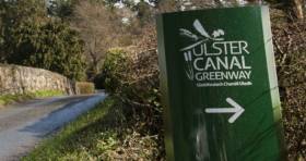
#InlandWaters - A series of three ‘community information events’ on the next phase of the Ulster Canal Greenway begins this week, with a meeting at Tyholland Community Centre in Co Monaghan from 4pm to 8pm tomorrow (Tuesday 2 October).

This will be followed by events at Middletown Community Parish Hall, Co Armagh on Wednesday 10 October, and Smithborough Community Hall, Co Monaghan on Thursday 18 October, both also from 4pm to 8pm.

Waterways Ireland; Monaghan County Council; Armagh City, Banbridge and Craigavon Borough Council; and East Border Region Ltd are working in partnership to deliver Phase 2 of the Ulster Canal Greenway.

Landowners, local communities and the general public are invited to these information events to find out more about the project.​

Published in Inland Waterways

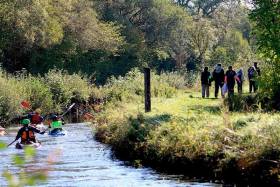
#InlandWaters - Tourism and activity providers along with local communities along the route are invited to attend a series of workshops aimed at developing the Royal Canal as an attraction for domestic tourism and visitors from abroad.

Coming ahead of next year’s launch of the Royal Canal Greenway, the capacity-building workshops will help project partners engage with local trades, businesses and others to showcase the proposed plans in developing the Royal Canal as a destination.

The long-awaited Blueway and Greenway trails on and along the 144km of canal and towpath from Dublin to Longford will be the focus of the workshops, the first of which will be held next week in Mullingar on Thursday 24 May from 6.30pm at the Mullingar Park Hotel.

Dates and venues for subsequent workshops in Longford town, Maynooth and Dublin are to be confirmed. All are hosted by Waterways Ireland with the respective local authorities.

Once complete, the Royal Canal Greenway will be the longest off-road walking and cycling trail on the island of Ireland.

Accompanying this will be a series of Blueway developments, the first being located in Mullingar where a 22km paddling trail and activity hub will be established.

The workshops will encourage the development of activity based packages, dining and accommodation packages and promotional materials which will activate the region and place the product in the ‘shop window’ for both the domestic and international tourist.

The Royal Canal is also at the heart of Ireland’s Ancient East and Ireland’s Hidden Heartlands, two tourism initiatives developed by Fáilte Ireland.

Published in Inland Waterways

The Minister for Transport, Tourism and Sport, Shane Ross TD and the Minister for Culture, Heritage and the Gaeltacht, Heather Humphreys TD, have today launched the EU-funded €4.95m Ulster Canal Greenway Project which will see the development of an off-road sustainable travel route between Smithborough, Co Monaghan and Middletown, Co Armagh.

The project is supported by the European Union's INTERREG VA Programme, managed by the Special EU Programmes Body (SEUPB). The project is also supported by the Department of Transport, Tourism and Sport in Ireland and the Department for Infrastructure in Northern Ireland. The project partners, led by Waterways Ireland, are Monaghan County Council, Armagh City, Banbridge & Craigavon Borough Council and East Border Region Ltd.

Minister Ross stated “This is a wonderful initiative. Greenways connect communities, promote healthier lifestyles and encourage engagement with the outdoors. They also offer active travel opportunities for both pedestrians and cyclists and have proven to be a major attraction for visitors.

I’m very pleased to be launching Phase 2 of the Ulster Canal Greenway here today. Creating a new Greenway involves years of planning, construction and goodwill from those in surrounding lands. But it’s a commitment that delivers back to the community in spades. This Greenway promises to be a major asset to surrounding areas, as it brings the old towpaths of the disused Ulster Canal back into use and extends the Monaghan Town Greenway by 22km in a very welcome cross-border project. By 2020, the Greenway will link Smithborough, Co Monaghan to Middleton, Co Armagh.

I very much look forward to making use of it in the future and I encourage you all to do likewise.”

The Ulster Canal Greenway (UCG) Phase 2 project is a pioneering move to develop the first sustainable transport alternative for cross-border commuters between Smithborough, Co. Monaghan and Middletown, Co. Armagh. Monaghan to Northern Ireland is the second highest of all South-North commuter flows, and Armagh to Ireland is the third highest of all North-South flows. The project valued at €4.95m aims to construct 22km of new cross-border Greenway by 2020 and actively to promote commuter behavioural change through a targeted community engagement programme. It will result in a 4.5% increase in the number of cross-border journeys via walking / cycling by 2023. The project is designed to connect with the completed Phase I section, which utilises the disused Ulster Canal to provide a highly strategic route linking the east/ west sides of Monaghan.

Minister Heather Humphreys in whose constituency the Greenway will run, said at the launch

“I am delighted that Waterways Ireland, an agency under the remit of my own Department, have agreed to act as the lead partner for this flagship cross-border project. The first phase of the Greenway, here in Monaghan, already attracts over 100,000 users per year and has been a fantastic success since it opened in 2014. The further expansion of the Greenway will strengthen cross border relations by directly linking communities North and South of the border. The provision of this landmark recreational amenity will also provide a huge tourism boost for County Monaghan and the wider border region. “

Speaking at the event Gina McIntyre, Chief Executive Officer with the Special EU Programmes Body, said: “When completed this cross border project will help to meet some important targets under the sustainable transport objective of the EU’s INTERREG VA Programme. It will encourage more people to get out of their cars and increase the number of cross-border journeys made by walking and cycling, thereby helping to reduce our collective carbon footprint.

“Not only will this produce many benefits for the region, but the project is also making a contribution towards the EU’s ‘Europe 2020’ strategy which has been specifically designed to reduce greenhouse gas emissions and help safeguard the environment,” she continued.

Also attending the launch on the day were children from St John’s Primary School, Middletown, Co Armagh and Gaelscoil Ultain, St Marys Boys School and St Louis Girls School The extended Ulster Canal Greenway route will create the first cross-border greenway that will enable cyclists and walkers commute to work and study in future years.

The Cathaoirleach of Monaghan County Council Cllr Cathy Bennett stated ‘The 4km Monaghan Town Greenway has been a huge success and it attracts over 100,000 users annually. I am delighted that the INTERREG VA programme is supporting the next 22km section of the Ulster Canal Greenway. This new phase of the greenway will join communities north and south of the border, bringing huge benefits to our area and encouraging even more people to get out walking and cycling on a daily basis.’

Alderman Elizabeth Ingram, Armagh City, Banbridge & Craigavon Borough Council stated "A key facet of our vision is to engage and support initiatives that protect and safeguard our environment for future generations to come that is why we are delighted to partner up on the EU funded Ulster Canal Greenway project. Bringing about substantial environmental benefits whilst enhancing the quality of life in the area, this pioneering project will deliver an alternative and sustainable pathway for cyclists and walkers to commute between both sides of the border. The collaborative project highlights our commitment to growing a connected, welcoming and healthy community.”

The project will also contribute to a deepened level of partnership between key stakeholders and to the development of expertise and dissemination of best practice in delivering cross-border projects.

Published in Inland Waterways
Tagged under

Waterford Greenway, the longest off-road walking and cycling experience in Ireland, is to officially open tomorrow, Saturday (March 25). The eagerly awaited €15 million project stretches 46km from Waterford City to Dungarvan along the former Great Southern and Western Railway line.

The major tourism initiative now features in the Atlantic Coast Route of EuroVelo, a long distance cycling network connecting Europe. It is also part of Fáilte Ireland’s Ancient East experience.

The official opening of the Greenway will take place at the old Kilmacthomas Station House, the half-way mark on the dedicated walking and cycling path. Minister for Housing, Planning and Local Government, Simon Coveney TD will attend the ribbon cutting ceremony. Multiple family-friendly events will also take place on Saturday at Waterford Institute of Technology’s West Campus, the Dungarvan Causeway and Kilmacthomas village.

Speaking ahead of the launch, Mayor of Waterford, Cllr Adam Wyse outlined: “It is fitting that the Waterford Greenway officially opens on March 25th, exactly 50 years after the last passenger train travelled along the old railway line between Dungarvan and Waterford. The Waterford Greenway is steeped in history and natural heritage, and I’m delighted to see it now re-imagined into an amenity that will continue to give great enjoyment to the people of Waterford and visitors to this great county well into the future.”

The Waterford Greenway was developed by Waterford City and County Council with the co-operation of local property owners and communities along the route, and supporting funding from the Department of Transport, Tourism and Sport.

Also attending the official opening will be Chief Executive of Sport Ireland, Olympic silver medallist and Waterford native, John Treacy, who said: “Participation in sport and physical activity across all ages and backgrounds is vitally important. Having a world-class facility like the Greenway, with its beautiful vista and fantastic amenities, will encourage and provide opportunities to people of all ages, the length and breadth of Waterford, to get out and get active.

“I am also delighted that Waterford Greenway will be the 900th trail listed on the National Trails Register, which is managed by Sport Ireland.”

The route features 11 bridges, three viaducts and a 400-metre tunnel and takes in Waterford City, Mount Congreve, Kilmeaden, Kilmacthomas, Shanacool, Scartore and Dungarvan.

Saturday’s celebrations between 12pm and 4pm include a Viking Village and live music at WIT West Campus, while at Kilmacthomas village, revellers are invited to step back in time with a vintage car display and traditional Fair Day Mart. At the Dungarvan Causeway, there will be fairground rides, live music, juggling and stilt walking. There will also be free walks and talks throughout the afternoon, along with railway heritage exhibitions at Waterford County Museum in Dungarvan, and Kilmacthomas Library.

Published in Coastal Notes
Tagged under

#InlandWaters - The extension of the Royal Canal Greenway in Westmeath from Coolnahay Harbour to the Longford county boundary was officially opened last week.

The new greenway, a 14.4km cycle way, links with the 32.6km already provided along the waterway under an earlier scheme.

Minister of State for Tourism and Sport Patrick O'Donovan joined Cllr Frank McDermott, Cathaoirleach of Westmeath County Council and Waterways Ireland chief executive Dawn Livingstone to officially opened this phase of the cycle way on Friday 7 October.

The aim of the project is to increase the number of walkers and cyclers to the Royal Canal, whether commuting along the Greenway or for recreational purposes.

The project, made possible with funding granted in 2013 and a licence from Waterways Ireland, involved upgrading works and surface dressing on certain sections of the Royal Canal along with informative signage, seating and cycle-friendly gates.

The new cycle path is already in use by both pedestrians and cyclists and is reportedly proving a popular recreational facility in the area.

Published in Inland Waterways

#RoyalCanal - The Royal Canal path from Ashtown to Castleknock is the latest section of the ambitious Dublin-Galway coast-to-coast greenway to open, with Transport Minister Leo Varadkar cutting the ribbon on the 2.5km stretch today at the 12th Lock (Friday 27 June).

The €2 million section across West Dublin is intended to be valuable local amenity for walkers, cyclists and other local residents - but it will also form part of the first national greenway running right across the country, from the Dublin Docklands to the Atlantic coast in Galway.

In addition, Minister Varadkar announced details of the preferred route for the western section of the greenway between Athlone and Galway, running through Shannonbridge, Loughrea, Craughwell, Clarinbridge and Oranmore to the Galway coast.

“It’s great to see the Galway to Dublin Greenway taking shape," he said. "Two years ago we only had a simple idea to run a greenway along the Royal Canal. Now three sections are open to the public and being used actively by walkers, cyclists and for other leisure pursuits."

The minister elaborated on the "incremental approach" for the greenway project, developing sections as funding becomes available.

"Although we still have a huge task in finishing the rest of the project, I’m really looking forward to walking, cycling or running along the entire route between Dublin and Galway when it’s finally completed.”

Opened so far, along with the Ashtown-Castleknock path, are the section from Guild Street to Sherriff Street in Dublin's Docklands, and a 25km route in Westmeath from Mullingar to the Meath border.

A 40km section between Mullingar and Athlone will be completed next year, after €4 million was allocated by Minister of State for Transport Alan Kelly. Two further sections totalling 40km in Kildare and Meath are at shovel-ready stage and work will start as soon as funding becomes available.

Published in Inland Waterways

General Information on using Waterways Ireland inland navigations

Safety on the Water

All users of the navigations are strongly recommended to make themselves aware of safety on the water for whatever activity they are involved in and to read the advice offered by the various governing bodies and by:

The Dept. of Transport, Ireland: www.gov.ie/transport and The Maritime and Coastguard Agency, UK, The RNLI – Water Safety Ireland for information in terms of drowning prevention and water safety.

Registration of Vessels

All vessels using the Shannon Navigation, which includes the Shannon-Erne Waterways and the Erne System must be registered with Waterways Ireland. Only open undecked boats with an engine of 15 horsepower or less on the Shannon Navigation, and vessels of 10 horsepower or less on the Erne System, are exempt. Registration is free of charge.

Craft registration should be completed online at: https://www.waterwaysireland.org/online-services/craft-registration

Permits for use of the Grand and Royal Canals and the Barrow Navigation

All vessels using the Grand and Royal Canals and the Barrow Navigation must display appropriate valid Permit(s) i.e A Combined Mooring and Passage Permit (€126) and if not intending to move every five days, an Extended Mooring Permit (€152).

Permit applications should be completed online at: https://www.waterwaysireland.org/online-services/canal-permits

Passage on the Royal and Grand Canals – Dublin Area

For boat passage through the locks east of Lock 12 into / out of Dublin on either the Royal or Grand Canals, Masters are requested to contact the Waterways Ireland Eastern Regional Office (M-F 9.30am-4.30pm) on tel: +353(0)1 868 0148 or email [email protected] prior to making passage in order to plan the necessary lock-keeping assistance arrangements.

On the Grand Canal a minimum of two days notice prior to the planned passage should be given, masters should note that with the exception of pre-arranged events, a maximum of 2 boats per day will be taken through the locks, travelling either east or west.

Movements in or out of the city will be organised by prior arrangement to take place as a single movement in one day. Boaters will be facilitated to travel the system if their passage is considered to be safe by Waterways Ireland and they have the valid permit(s) for mooring and passage.

Newcomen Lifting Bridge

On the Royal Canal two weeks’ notice of bridge passage (Newcomen Lifting Bridge) is required for the pre-set lift date, and lock assistance will then also be arranged. A minimum of 2 boats is required for a bridge lift to go ahead.

Waterways Ireland Eastern Regional Office (Tel: +353(0)1 868 0148 or [email protected] ) is the point of contact for the bridge lift.

A maximum number of boats passing will be implemented to keep to the times given above for the planned lifts (16 for the Sat / Sun lifts & 8 for the weekday lifts). Priority will be given on a first come first served basis.

On day of lift, boaters and passengers must follow guidance from Waterways Ireland staff about sequence of passage under bridge & through Lock 1, and must remain within signed and designated areas.

Events Held on the Waterways

All organised events taking place on the waterways must have the prior approval of Waterways Ireland. This is a twelve week process and application forms must be accompanied with the appropriate insurance, signed indemnity and risk assessment. The application should be completed on the Waterways Ireland events page at :

https://www.waterwaysireland.org/online-services/event-approval

Time Limits on Mooring in Public Harbours

On the Shannon Navigation and the Shannon-Erne Waterway craft may berth in public harbours for five consecutive days or a total of seven days in any one month.

On the Erne System, revised Bye Laws state that: No master or owner shall permit a vessel, boat or any floating or sunken object to remain moored at or in the vicinity of any public mooring, including mooring at any other public mooring within 3 kilometres of that location, for more than 3 consecutive days and shall not moor at that same mooring or any other public mooring within 3 kilometres of that location within the following 3 consecutive days without prior permission by an authorised official.

Winter Mooring on the Shannon Navigation and Shannon Erne Waterway

Winter mooring may be availed of by owners during the period 1 Nov to 31 Mar by prior arrangement and payment of a charge of €63.50 per craft. Craft not availing of Winter Mooring must continue to comply with the “5 Day Rule”. Winter Mooring applications should be completed online at : https://www.waterwaysireland.org/online-services/winter-moorings-booking

Owners should be aware that electricity supply and water supply to public moorings is disconnected for the winter months. This is to protect against frost damage, to reduce running costs and to minimise maintenance requirements during the winter months.

Vessel owners are advised that advance purchasing of electricity on the power bollards leading up to the disconnection date should be minimal. Electricity credit existing on the bollards will not be recoverable after the winter decommissioning date. Both services will be reinstated prior to the commencement of the next boating season.

Smart Cards

Waterways Ireland smart cards are used to operate locks on the Shannon Erne Waterway, to access the service blocks, to use the pump-outs along the navigations, to avail of electrical power at Waterways Ireland jetties.

Berthing in Public Harbours

Masters are reminded of the following:

  • Equip their vessel with mooring lines of appropriate length and strength and only secure their craft to mooring bollards and cleats provided for this purpose.
  • Ensure the available berth is suitable to the length of your vessel, do not overhang the mooring especially on finger moorings on floating pontoon moorings.
  • Ensure mooring lines, electric cables and fresh water hoses do not create a trip hazard on public jetties for others users.
  • Carry sufficient fenders to prevent damage to your own vessel, other vessels and WI property.
  • Allow sufficient space between your vessel and the vessel ahead /astern (c.1m) for fire safety purposes and /or to recover somebody from the water.
  • Do not berth more than two vessels side by side and ensure there is safe access/egress at all times between vessels and onto the harbour itself.
  • Do not berth in such a way to prevent use of harbour safety ladders, slipways or pump-outs.
  • Do not allow the bow of your vessel to overhang the walkway of a floating mooring thus creating a hazard for others with an overhanging anchor or bow fendering.
  • Animals are not allowed to be loose or stray at any time.
  • Harbour and jetty infrastructure such as railings, power pedestals, fresh water taps, electric light poles, safety bollards, ladders etc are not designed for the purpose of mooring craft , they will not bear the strain of a vessel and will be damaged.
  • At Carrybridge on the Erne System, Masters of vessels are not permitted to use stern on mooring. Masters of vessels must use the mooring fingers for mooring of vessels and for embarkation / disembarkation from vessels.

Passenger Vessel Berths

Masters of vessels should not berth on passenger vessel berths where it is indicated that an arrival is imminent. Passenger vessels plying the navigations generally only occupy the berths to embark and disembark passengers and rarely remain on the berths for extended periods or overnight.

Lock Lead-in Jetties

Lead-in jetties adjacent to the upstream and downstream gates at lock chambers are solely for the purpose of craft waiting to use the lock and should not be used for long term berthing.

Vessel Wake

Vessel wake, that is, the wave generated by the passage of the boat through the water, can sometimes be large, powerful and destructive depending on the hull shape and engine power of the vessel. This wake can be detrimental to other users of the navigation when it strikes their craft or inundates the shoreline or riverbank. Masters are requested to frequently look behind and check the effect of their wake / wash particularly when passing moored vessels, on entering harbours and approaching jetties and to be aware of people pursuing other activities such as fishing on the riverbank.

Speed Restriction

A vessel or boat shall not be navigated on the Shannon Navigation at a speed in excess of 5 kph when within 200 metres of a bridge, quay, jetty or wharf, when in a harbour or canal or when passing within 100 metres of a moored vessel or boat.

Vessels navigating the Shannon-Erne Waterway should observe the general 5 kph speed limit which applies along the waterway. This is necessary in order to prevent damage to the banks caused by excessive wash from vessels.

Vessels navigating the Erne System should observe the statutory 5kt / 6mph / 10kph speed limit areas.

A craft on the Royal and Grand canals shall not be navigated at a speed in excess of 6km per hour.

A craft on the Barrow Navigation shall not be navigated at a speed in excess of 11km per hour except as necessary for safe navigation in conditions of fast flow.

Bank Erosion

Narrow sections of all the navigations are particularly prone to bank erosion due to the large wash generated by some craft. Masters are requested to be vigilant and to slow down to a speed sufficient to maintain steerage when they observe the wash of their craft inundating the river banks.

Unusual Waterborne Activity

Unusual waterborne vessels may be encountered from time to time, such as, hovercraft or amphibious aircraft / seaplanes. Masters of such craft are reminded to apply the normal “Rule of the Road” when they meet conventional craft on the water and to allow extra room to manoeuvre in the interest of safety.

Sailing Activity

Mariners will encounter large numbers of sailing dinghies from late June to August in the vicinity of Lough Derg, Lough Ree and Lower Lough Erne. Sailing courses are marked by yellow buoys to suit weather conditions on the day. Vessels should proceed at slow speed and with due caution and observe the rules of navigation when passing these fleets, as many of the participants are junior sailors under training.

Rowing

Mariners should expect to meet canoes and vessels under oars on any part of the navigations, but more so in the vicinity of Athlone, Carrick-on-Shannon, Coleraine, Enniskillen and Limerick. Masters are reminded to proceed at slow speed and especially to reduce their wash to a minimum when passing these craft as they can be easily upset and swamped due to their very low freeboard and always be prepared to give way in any given traffic situation.

Canoeing

Canoeing is an adventure sport and participants are strongly recommended to seek the advice of the sport’s governing bodies i.e Canoeing Ireland and the Canoe Association of Northern Ireland, before venturing onto the navigations.

Persons in charge of canoes are reminded of the inherent danger to these craft associated with operating close to weirs, sluice gates, locks and other infrastructure particularly when rivers are in flood and large volumes of water are moving through the navigations due to general flood conditions or very heavy localised precipitation e.g. turbulent and broken water, stopper waves. Shooting weirs is prohibited without prior permission of Waterways Ireland.

Canoeists should check with lockkeepers prior entering a lock to ensure passage is done in a safe manner. Portage is required at all unmanned locks.

Canoe Trail Network – "Blueways"

Masters of powered craft are reminded that a canoe trail network is being developed across all navigations and to expect more organised canoeing along these trails necessitating slow speed and minimum wash when encountering canoeists, rowing boats etc

Rockingham and Drummans Island Canals – Lough Key

It is expected that work on Rockingham and Drummans Island Canals on Lough Key will be completed in 2021. Access to these canals will be for non-powered craft only, eg canoes, kayaks, rowing boats.

Fast Powerboats and Personal Watercraft (Jet Skis)

Masters of Fast Powerboats (speed greater than 17kts) and Personal Watercraft (i.e.Jet Skis) are reminded of the inherent dangers associated with high speed on the water and especially in the confines of small bays and narrow sections of the navigations. Keeping a proper look-out, making early alterations to course and /or reducing speed will avoid conflict with slower vessels using the navigation. Personal Watercraft are not permitted to be used on the canals.

Towing Waterskiers, Wakeboarders, Doughnuts etc

Masters of vessels engaged in any of these activities are reminded of the manoeuvring constraints imposed upon their vessel by the tow and of the added responsibilities that they have to the person(s) being towed. These activities should be conducted in areas which are clear of conflicting traffic. It is highly recommended that a person additional to the master be carried to act as a “look-out” to keep the tow under observation at all times.

Prohibition on Swimming

Swimming in the navigable channel, particularly at bridges, is dangerous and is prohibited due to the risk of being run over by a vessel underway in the navigation.

Age Restrictions on operating of powered craft

In the Republic of Ireland, Statutory Instrument 921 of 2005 provides the legal requirements regarding the minimum age for operating of powered craft. The Statutory Instrument contains the following requirements:

- The master or owner of a personal watercraft or a fast power craft shall take all reasonable steps to ensure that a person who has not attained the age of 16 years does not operate or control the craft

- The master or owner of a pleasure craft powered by an engine with a rating of more than 5 horse power or 3.7 kilowatts shall take all reasonable steps to ensure that a person who has not attained the age of 12 years does not operate or control the craft.

Lifejackets and Personal Flotation Devices (PFDs)

Lifejackets and PFD’s are the single most important items of personal protective equipment to be used on a vessel and should be worn especially when the vessel is being manoeuvred such as entering / departing a lock, anchoring, coming alongside or departing a jetty or quayside.

In the Republic of Ireland, Statutory Instrument 921 of 2005 provides the legal requirements regarding the wearing of Personal Flotation Devices. The Statutory Instrument contains the following requirements:

- The master or owner of a pleasure craft (other than a personal watercraft) shall ensure, that there are, at all times on board the craft, sufficient suitable personal flotation devices for each person on board.

- A person on a pleasure craft (other than a personal watercraft) of less than 7 metres length overall shall wear a suitable personal flotation device while on board an open craft or while on the deck of decked craft, other than when the craft is made fast to the shore or at anchor.

- The master or owner of a pleasure craft (other than a personal watercraft) shall take all reasonable steps to ensure that a person who has not attained the age of 16 years complies with paragraph above.

- The master or owner of a pleasure craft (other than a personal watercraft), shall take all reasonable steps to ensure that a person who has not attained the age of 16 years wears a suitable personal flotation device while on board an open craft or while on the deck of a decked craft other than when it is made fast to the shore or at anchor.

- The master or owner of a pleasure craft (other than a personal watercraft) shall take all reasonable steps to ensure that a person wears a suitable personal flotation device, at all times while – (a) being towed by the craft, (b) on board a vessel or object of any kind which is being towed by the craft.

Further information is available at: http://www.irishstatutebook.ie/eli/2005/si/921/made/en/print

Firing Range Danger Area – Lough Ree

The attention of mariners is drawn to the Irish Defence Forces Firing Range situated in the vicinity of buoys No’s 2 and 3, on Lough Ree on the Shannon Navigation. This range is used regularly for live firing exercises, throughout the year, all boats and vessels should stay clear of the area marked with yellow buoys showing a yellow "X" topmark and displaying the word "Danger".

Shannon Navigation, Portumna Swing Bridge Tolls

No attempt should be made by Masters’ of vessels to pay the bridge toll while making way through the bridge opening. Payment will only be taken by the Collector from Masters when they are secured alongside the jetties north and south of the bridge.

Navigating from Killaloe to Limerick on the Shannon Navigation

The navigation from Killaloe to Limerick involves passage through Ardnacrusha locks, the associated headrace and tailrace and the Abbey River into Limerick City. Careful passage planning is required to undertake this voyage. Considerations include: lock passage at Ardnacrusha, water flow in the navigation, airdraft under bridges on Abbey River in Limerick, state of tide in Limerick

Users are advised to contact the ESB Ardnacrusha hydroelectric power station (00353 (0)87 9970131) 48 hours in advance of commencing their journey to book passage through the locks at Ardnacrusha. It is NOT advised to undertake a voyage if more than one turbine is operating (20MW), due to the increased velocity of flow in the navigation channel, which can be dangerous. To ascertain automatically in real time how many turbines are running, users can phone +353 (0)87 6477229.

For safety reasons the ESB has advised that only powered craft with a capacity in excess of 5 knots are allowed to enter Ardnacrusha Headrace and Tailrace Canals.

Passage through Sarsfield Lock should be booked on +353-87-7972998, on the day prior to travel and it should be noted also that transit is not possible two hours either side of low water.

A Hydrographic survey in 2020 of the navigation channel revealed that the approach from Shannon Bridge to Sarsfield Lock and the Dock area has silted up. Masters of vessels and water users are advised to navigate to the Lock from Shannon bridge on a rising tide one or two hours before High Tide.

Lower Bann Navigation

The attention of all users is drawn to the “Users Code for the Lower Bann”, in particular to that section covering “Flow in the River” outlining the dangers for users both on the banks and in the navigation, associated with high flow rates when the river is in spate. Canoeists should consult and carry a copy of the “Lower Bann Canoe Trail” guide issued by the Canoe Association of Northern Ireland. Users should also contact the DfI Rivers Coleraine, who is responsible for regulating the flow rates on the river, for advisory information on the flow rates to be expected on any given day.

DfI Rivers Coleraine. Tel: 0044 28 7034 2357 Email: [email protected]

Lower Bann Navigation – Newferry – No wake zone

A No Wake Zone exists on the Lower Bann Navigation at Newferry. Masters of vessels are requested to proceed at a slow speed and create no wake while passing the jetties and slipways at Newferry.

Overhead Power Lines (OHPL) and Air draft

All Masters must be aware of the dangers associated with overhead power lines, in particular sailing vessels and workboats with cranes or large air drafts. Voyage planning is a necessity in order to identify the location of overhead lines crossing the navigation.

Overhead power line heights on the River Shannon are maintained at 12.6metres (40 feet) from Normal Summer level for that section of navigation, masters of vessels with a large air draft should proceed with caution and make additional allowances when water levels are high.

If a vessel or its equipment comes into contact with an OHPL the operator should NOT attempt to move the vessel or equipment. The conductor may still be alive or re-energise automatically. Maintain a safe distance and prevent third parties from approaching due to risk of arcing. Contact the emergency services for assistance.

Anglers are also reminded that a minimum ground distance of 30 metres should be maintained from overhead power lines when using a rod and line.

Submarine Cables and Pipes

Masters of vessels are reminded not to anchor their vessels in the vicinity of submarine cables or pipes in case they foul their anchor or damage the cables or pipes. Look to the river banks for signage indicating their presence.

Water Levels - Precautions

Low Water Levels:

When water levels fall below normal summer levels masters should be aware of:

Navigation

To reduce the risk of grounding masters should navigate on or near the centreline of the channel, avoid short cutting in dog-legged channels and navigating too close to navigation markers.

Proceeding at a slow speed will also reduce “squat” effect i.e. where the vessel tends to sit lower in the water as a consequence of higher speed.

Slipways

Reduced slipway length available under the water surface and the possibility of launching trailers dropping off the end of the concrete apron.

More slipway surface susceptible to weed growth requiring care while engaged in launching boats, from slipping and sliding on the slope. Note also that launching vehicles may not be able to get sufficient traction on the slipway once the craft is launched to get up the incline.

Bank Erosion

Very dry riverbanks are more susceptible to erosion from vessel wash.

Lock Share

Maximising on the number of vessels in a lock will ensure that the total volume of water moving downstream is decreased. Lock cycles should be used for vessels travelling each way.

High Water Levels:

When water levels rise above normal summer level masters should be aware of:

Navigation

Navigation marks will have reduced height above the water level or may disappear underwater altogether making the navigable channel difficult to discern.

In narrow sections of the navigations water levels will tend to rise more quickly than in main streams and air draft at bridges will likewise be reduced.

There will also be increased flow rates particularly in the vicinity of navigation infrastructure such as bridges, weirs, locks etc where extra care in manoeuvring vessels will be required.

Harbours and Jetties

Due care is required in harbours and at slipways when levels are at or near the same level as the harbour walkways' as the edge will be difficult to discern especially in reduced light conditions. It is advised that Personal Flotation Devices be worn if tending to craft in a harbour in these conditions.

Slipways

Slipways should only be used for the purpose of launching and recovering of water craft or other objects from the water. Before using a slipway it should be examined to ensure that the surface has sufficient traction/grip for the intended purpose such as launching a craft from a trailer using a vehicle, that there is sufficient depth of water on the slipway to float the craft off the trailer before the concrete apron ends and that the wheels of the trailer do not drop off the edge of the slipway. That life-saving appliances are available in the vicinity, that the vehicle is roadworthy and capable of coping with the weight of the trailer and boat on the incline. It is recommended that slipway operations are conducted by two persons.

Caution to be Used in Reliance upon Aids to Navigation

The aids to navigation depicted on the navigation guides comprise a system of fixed and floating aids to navigation. Prudent mariners will not rely solely on any single aid to navigation, particularly a floating aid to navigation. With respect to buoys, the buoy symbol is used to indicate the approximate position of the buoy body and the ground tackle which secures it to the lake or river bed. The approximate position is used because of the practical limitations in positioning and maintaining buoys in precise geographical locations. These limitations include, but are not limited to, prevailing atmospheric and lake/river conditions, the slope of and the material making up the lake/river bed, the fact that the buoys are moored to varying lengths of chain, and the fact that the buoy body and/or ground tackle positions are not under continuous surveillance. Due to the forces of nature, the position of the buoy body can be expected to shift inside and outside the charted symbol.

Buoys and perches are also moved out of position or pulled over by those mariners who use them to moor up to instead of anchoring. To this end, mariners should always monitor their passage by relating buoy/perch positions with the published navigation guide. Furthermore, a vessel attempting to pass close by always risks collision with a yawing buoy or with the obstruction that the buoy or beacon/perch marks.

Masters of Vessels are requested to use the most up to date Navigation guides when navigating on the Inland Waterways.

Information taken from Special Marine Notice No 1 of 2023