Menu

Ireland's sailing, boating & maritime magazine

Displaying items by tag: Whiterocks

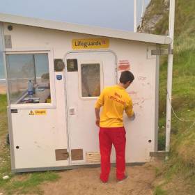
#Vandalism - Vandals have caused an estimated £800 (€900) worth of damage to an RNLI lifeguard unit at Whiterocks on the Causeway Coast.

Following two of the busiest days of the summer season so far in Northern Ireland, the RNLI team at Whiterocks arrived at work yesterday morning (Wednesday 19 July) to see that their unit, located near the entrance to the North Coast beach, had been extensively damaged.

The charity’s lifeguards discovered that the vandals had left behind broken bottles and a barbecue, while the unit’s aerial mount required for VHF communications had also been damaged.

A large rock which had been thrown at the hut damaged the unit’s outer skin, piercing the inner plywood and leaving a two-inch hole in the unit, which was also covered with indecent graffiti.

RNLI lifeguard supervisor Karl O’Neill said the damage to the aerial mount had threatened vital VHF communications, while the rock damage meant the unit was no longer watertight.

“Our lifeguards rely on the aerial to communicate with each other when on patrol and to communicate with their colleagues in the coastguard in the event of an emergency,” he said. 

“Thankfully the damage has not rendered our communications off-service but should it have, and should it have happened during the last two days, which brought thousands of people to our beaches to enjoy the good weather, lives could have been put at risk.

“It is very disappointing for our lifeguards, who have been working hard to keep people safe, to turn up this morning after two busy days and see the unit they need to carry out their job has been so badly damaged. It really does dampen spirits.”

It is estimated that the repairs to the beach lifeguard unit will run into hundreds of pounds for the charity.

The RNLI is working closely with the PSNI who have appealed for anyone with any information to come forward.

“We would appeal to those doing this damage to be mindful that the RNLI is a charity,” said O’Neill. “Our lifeguards are an essential part of what is a seamless rescue service that saves lives from the beach to the open sea.

“Our lifeguards’ primary role at Whiterocks and on all lifeguarded beaches on the Causeway Coast is to make sure the beach can be enjoyed safely by the public. We want them to be able to continue to do that safely and with peace of mind.”

Published in Coastal Notes

#CliffFall - An RNLI beach lifeguard aided a man who fell onto rocks while walking a steep cliff path on Whiterocks beach in Portrush yesterday afternoon (Wednesday 30 March).

The call for help came after a member of the group the man was with observed him fall just before 1pm and raised the alarm.

After arriving on scene, senior RNLI lifeguard Jamie Russell immediately began to administer casualty care to the conscious man, who had fallen some 12 feet from the coastal path. He was joined on scene by a paramedic and they continued to provide assistance.

However with an incoming tide and a challenging location, it was decided that removing the casualty would require the assistance of Coleraine coastguard.

The man was secured on a stretcher and carefully moved by the group around the rocks to a waiting ambulance.

Commenting on the callout, RNLI lifeguard supervisor Karl O’Neill said: "This incident was quite a challenging one to respond to due to the nature and location of the fall.

"Thankfully the man was conscious but we did not want to risk any further discomfort or injury by moving him ourselves. I would like to thank members of Coleraine coastguard for their assistance."

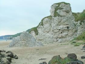
Whiterocks is one of five beaches being patrolled by RNLI lifeguard during the Easter holidays, continuing till Monday 4 April, as previously reported on Afloat.ie.

Published in Coastal Notes

#Rescue - RNLI lifeguards assisted two stand-up paddle boarders on Whiterocks beach in Portrush on Saturday (11 July) during strong offshore winds.

Senior RNLI lifeguard Bosco McAuley spotted two people in difficulty at 3.40pm approximately 100 metres out to sea within the lifeguards flagged patrol zone on the beach.

The two women were both on stand-up paddle boards when they got caught off guard by a strong offshore wind. Weather conditions were described as overcast and windy at the time, with about 1-2 foot of surf.


After observing the situation, McAuley asked his RNLI lifeguard colleagues Bruce Traill and Ali Boyd to assist. Traill quickly put on his RNLI rescue watercraft kit while Boyd launched the jetski into the water.


McAuley then proceeded to the two paddle boarders and assisted them safely back to shore before going back to retrieve the two paddle boards.


"Offshore winds during the summer season can cause issues on the beaches, when these situations arise we are on scene and can quickly deal with them to ensure the public’s safety," said McAuley after the rescue.


RNLI supervisor Tim Doran added: "Anyone who gets into difficulty the water should try to remain calm, raise their arm and signal for help. Our lifeguards are well trained when it comes to spotting people in danger in the water and are quick to respond."

"
With numbers on the beaches expected to increase for the July holidays this week, Doran reminded people to be mindful of the RNLI’s key safety advice – particularly for those planning to use the water.

"If you are planning on visiting a beach this summer, choose a lifeguarded beach and swim between the red and yellow flags, which mark the safest area to swim and are an indicator that lifeguards are on duty.

"If you see someone else in trouble in the water, call on the help of a lifeguard or dial 999 and ask for the coastguard."

Published in Rescue
14th October 2010

Portrush Surf Cam Goes Live

Surfing action from Portrush can now be enjoyed from all around the world following the launch of a live webcam at Whiterocks Beach.

Martin Kelly of Portrush Surf School teamed up with the town's Royal Court Hotel to set up the webcam at the popular surfing spot as a tool for travelling waveriders to check out conditions from a distance.

"By checking the webcam they can now see first hand exactly what the waves are doing, saving them time and money on a potentially wasted journey," the former Irish surfing champion told the Coleraine Times. "This is a case of know before you go."

The movable camera will allow for many different views of the Co Antrim beach that will surely appeal to more than surfing fans.

To view the webcam visit www.portrushsurfschool.com

Published in Surfing

About Dublin Port 

Dublin Port is Ireland’s largest and busiest port with approximately 17,000 vessel movements per year. As well as being the country’s largest port, Dublin Port has the highest rate of growth and, in the seven years to 2019, total cargo volumes grew by 36.1%.

The vision of Dublin Port Company is to have the required capacity to service the needs of its customers and the wider economy safely, efficiently and sustainably. Dublin Port will integrate with the City by enhancing the natural and built environments. The Port is being developed in line with Masterplan 2040.

Dublin Port Company is currently investing about €277 million on its Alexandra Basin Redevelopment (ABR), which is due to be complete by 2021. The redevelopment will improve the port's capacity for large ships by deepening and lengthening 3km of its 7km of berths. The ABR is part of a €1bn capital programme up to 2028, which will also include initial work on the Dublin Port’s MP2 Project - a major capital development project proposal for works within the existing port lands in the northeastern part of the port.

Dublin Port has also recently secured planning approval for the development of the next phase of its inland port near Dublin Airport. The latest stage of the inland port will include a site with the capacity to store more than 2,000 shipping containers and infrastructures such as an ESB substation, an office building and gantry crane.

Dublin Port Company recently submitted a planning application for a €320 million project that aims to provide significant additional capacity at the facility within the port in order to cope with increases in trade up to 2040. The scheme will see a new roll-on/roll-off jetty built to handle ferries of up to 240 metres in length, as well as the redevelopment of an oil berth into a deep-water container berth.

Dublin Port FAQ

Dublin was little more than a monastic settlement until the Norse invasion in the 8th and 9th centuries when they selected the Liffey Estuary as their point of entry to the country as it provided relatively easy access to the central plains of Ireland. Trading with England and Europe followed which required port facilities, so the development of Dublin Port is inextricably linked to the development of Dublin City, so it is fair to say the origins of the Port go back over one thousand years. As a result, the modern organisation Dublin Port has a long and remarkable history, dating back over 300 years from 1707.

The original Port of Dublin was situated upriver, a few miles from its current location near the modern Civic Offices at Wood Quay and close to Christchurch Cathedral. The Port remained close to that area until the new Custom House opened in the 1790s. In medieval times Dublin shipped cattle hides to Britain and the continent, and the returning ships carried wine, pottery and other goods.

510 acres. The modern Dublin Port is located either side of the River Liffey, out to its mouth. On the north side of the river, the central part (205 hectares or 510 acres) of the Port lies at the end of East Wall and North Wall, from Alexandra Quay.

Dublin Port Company is a State-owned commercial company responsible for operating and developing Dublin Port.

Dublin Port Company is a self-financing, and profitable private limited company wholly-owned by the State, whose business is to manage Dublin Port, Ireland's premier Port. Established as a corporate entity in 1997, Dublin Port Company is responsible for the management, control, operation and development of the Port.

Captain William Bligh (of Mutiny of the Bounty fame) was a visitor to Dublin in 1800, and his visit to the capital had a lasting effect on the Port. Bligh's study of the currents in Dublin Bay provided the basis for the construction of the North Wall. This undertaking led to the growth of Bull Island to its present size.

Yes. Dublin Port is the largest freight and passenger port in Ireland. It handles almost 50% of all trade in the Republic of Ireland.

All cargo handling activities being carried out by private sector companies operating in intensely competitive markets within the Port. Dublin Port Company provides world-class facilities, services, accommodation and lands in the harbour for ships, goods and passengers.

Eamonn O'Reilly is the Dublin Port Chief Executive.

Capt. Michael McKenna is the Dublin Port Harbour Master

In 2019, 1,949,229 people came through the Port.

In 2019, there were 158 cruise liner visits.

In 2019, 9.4 million gross tonnes of exports were handled by Dublin Port.

In 2019, there were 7,898 ship arrivals.

In 2019, there was a gross tonnage of 38.1 million.

In 2019, there were 559,506 tourist vehicles.

There were 98,897 lorries in 2019

Boats can navigate the River Liffey into Dublin by using the navigational guidelines. Find the guidelines on this page here.

VHF channel 12. Commercial vessels using Dublin Port or Dun Laoghaire Port typically have a qualified pilot or certified master with proven local knowledge on board. They "listen out" on VHF channel 12 when in Dublin Port's jurisdiction.

A Dublin Bay webcam showing the south of the Bay at Dun Laoghaire and a distant view of Dublin Port Shipping is here
Dublin Port is creating a distributed museum on its lands in Dublin City.
 A Liffey Tolka Project cycle and pedestrian way is the key to link the elements of this distributed museum together.  The distributed museum starts at the Diving Bell and, over the course of 6.3km, will give Dubliners a real sense of the City, the Port and the Bay.  For visitors, it will be a unique eye-opening stroll and vista through and alongside one of Europe’s busiest ports:  Diving Bell along Sir John Rogerson’s Quay over the Samuel Beckett Bridge, past the Scherzer Bridge and down the North Wall Quay campshire to Berth 18 - 1.2 km.   Liffey Tolka Project - Tree-lined pedestrian and cycle route between the River Liffey and the Tolka Estuary - 1.4 km with a 300-metre spur along Alexandra Road to The Pumphouse (to be completed by Q1 2021) and another 200 metres to The Flour Mill.   Tolka Estuary Greenway - Construction of Phase 1 (1.9 km) starts in December 2020 and will be completed by Spring 2022.  Phase 2 (1.3 km) will be delivered within the following five years.  The Pumphouse is a heritage zone being created as part of the Alexandra Basin Redevelopment Project.  The first phase of 1.6 acres will be completed in early 2021 and will include historical port equipment and buildings and a large open space for exhibitions and performances.  It will be expanded in a subsequent phase to incorporate the Victorian Graving Dock No. 1 which will be excavated and revealed. 
 The largest component of the distributed museum will be The Flour Mill.  This involves the redevelopment of the former Odlums Flour Mill on Alexandra Road based on a masterplan completed by Grafton Architects to provide a mix of port operational uses, a National Maritime Archive, two 300 seat performance venues, working and studio spaces for artists and exhibition spaces.   The Flour Mill will be developed in stages over the remaining twenty years of Masterplan 2040 alongside major port infrastructure projects.

Source: Dublin Port Company ©Afloat 2020.