Displaying items by tag: Killiney Bay
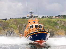
Dun Laoghaire Lifeboat Launched To Powerless Powerboat Off Killiney
#RNLI - Shorter evenings mean having a method of calling for help on the water is more important than ever.
The message from the RNLI came after the Dun Laoghaire lifeboat launched on Tuesday evening (4 September) to a powerboat with three on board that had broken down in Killiney Bay.
The volunteer lifeboat crew was requested to launch their all-weather lifeboat at 7.50pm following a report from the Irish Coast Guard.
Weather conditions were fair with a northern breeze and visibility was good as the all-weather lifeboat located and successfully towed the vessel back towards Dun Laoghaire Marina. All three onboard were uninjured.
Commenting after the callout, Dun Laoghaire RNLI coxswain Mark McGibney said: “The long evenings are starting to get shorter, so it is vital to have a means of calling for help in case you do end up in trouble.”
Dalkey Meeting to Discuss Proposed Oil Drilling

#'DALKEY ISLAND' PROSPECT – In response to a proposed exploratory search for oil and gas operation by Providence Resources off Dalkey Island, Co. Dublin, as previously reported on Afloat.ie, a public meeting is to be held by Dalkey Community Council next week, writes Jehan Ashmore.
The meeting to be held next Tuesday in Dalkey Town Hall (at 7.30 p.m.) is to discuss the Providence venture, named 'Dalkey Island' prospect, in reference to the island off the south-side suburb. The island and the coast along Dalkey is geographically the nearest landfall to where the proposed 'jack-up' drill rig would operate in block (33/21) in the Kish Bank Basin.
An online petition (see www.protectourcoast.net) by campaigners, entitled 'Protect Dublin Bay, Dalkey Island and Killiney Bay from Large Oil Drill 2012', has already gained large support, including signatures from overseas. They are in protest over Providence Resources application for a foreshore license which has been lodged with the Department of Environment.
Providence Resources propose to drill a single borehole for the exploratory well which is likely to be in an area only 6kms offshore of the Dalkey coastline. The island is designated a Special Protection Area (SPA) and notably where there have been sightings of bottlenose dolphins in neighbouring Killiney Bay.
Should the oil be commercially viable, the benefits of becoming self-sufficient and security of supply would be of significant economic benefit to Ireland. To date 100% of the country's oil and 95% of its gas is currently imported, and yet most of Ireland's natural resources are unexplored, according to Providence Resources.
Exploration is an expensive exercise and has no guarantee of discovery while the timeframe from discovery to production can typically take five to seven years.
"Yet," say Providence Resources, "the implications of discovering and utilising such a natural resource, and potentially becoming self-sufficient in energy terms, would be of significant economic benefit for Ireland Inc. in terms of taxation, employment, security of supply and skills development."
To read more information about Dalkey Island Prospect from Providence Resources, with maps, montages (including views from White Rock Beach) newsletters and video presentation visit www.providenceresources.com/dalkeyisland.aspx
- Dublin Bay
- bottlenose dolphins
- dalkey
- Dalkey Island
- Providence Resources
- Kish Bank Basin
- Coastal Notes
- Killiney Bay
- Special Protection Area
- Dalkey Community Council
- Foreshore License
- SPA
- 'Dalkey Island' prospect
- Coastal note news
- Department of Environment
- ProtectOurCoast
- Protect Dublin Bay,Dalkey Island and Killiney Bay from Large Oil Dril 2012
Campaign to Stop Planned Oil Drill off Dalkey Island

#DALKEY ISLAND PROSPECT - An online petition organised by Protect Our Coast in protest over plans by Providence Resources to start exploratory drilling for oil and gas off Dalkey Island, in south Co. Dublin, has reached over 2,000 signatures to date, including support from overseas.
Providence Resources are seeking permission from the Department of Environment for a foreshore licence to carry out site investigation and drill testing in waters depths of 20-30m in the Kish Bank Basin, at the Dalkey Island 'Prospect'.
They propose drilling one exploratory well some 6kms offshore, though the exact location chosen for the well site is subject to results of seismic surveys. This particularly area lies closer to the coastline, as it is on the more westerly fringes of the exploratory block (33-21) zone.
The campaigners object to the proximity of the well site off Dalkey Island which is designated a Special Protection Area (SPA). The island is home to a resident herd of goats, is rich in birdlife, seals and cetaceans, notably bottlenose dolphins in neighbouring Killiney Bay, which have drawn recent media attention and aided the objectives of the campaign, see www.protectourcoast.net
In addition they oppose the drilling location given its closeness to a large urban population and the risk of an oil-spill and consequent effects to humans and the environment throughout Dublin Bay.
If granted, exploratory work is due to start this year, with Providence claiming the entire process would take up to six months, between survey and drilling operations. During part of that timeframe, up to two seismic vessels will be employed, prior to deploying a 'jack-up' rig to the well site.
Should the oil be commercially viable, the benefits of becoming self-sufficient and security of supply would be of significant economic benefit to Ireland. To date 100% of the country's oil and 95% of its gas is currently imported, and yet most of Ireland's natural resources are unexplored, according to Providence Resources.
Exploration is an expensive exercise and has no guarantee of discovery while the timeframe from discovery to production can typically take five to seven years.
"Yet," say Providence Resources, "the implications of discovering and utilising such a natural resource, and potentially becoming self-sufficient in energy terms, would be of significant economic benefit for Ireland Inc. in terms of taxation, employment, security of supply and skills development."
To read more information about Dalkey Island Prospect from Providence Resources, with maps, montages (including views from White Rock Beach) newsletters and video presentation visit www.providenceresources.com/dalkeyisland.aspx
As previously reported on Afloat.ie, the application for the foreshore license is currently on view in Dalkey and Dun Laoghaire Garda stations. The application contains maps, plans, and drawings which can be inspected, noting the public consultation process ends on Thursday 2nd February 2012.
In addition for information from the Department of Environment's website, click HERE. Those wishing to make an objection or representation of the sought license should make submissions to the Foreshore Unit of the department on close of business (also) on Thursday 2nd February 2012.
.
- Dalkey Island Prospect
- Dublin Bay News
- Providence Resources
- Protect Our Coast
- Dublin Bay Oil drilling
- Killiney Bay
- Dalkey Island
- Dalkey Island Goats
- Dalkey Dolphins
- Department of the Environment
- Foreshore License
- White Rock Beach
- Killiney Beach
- Kish Bank Basin
- Special Protection Area
- SPA
- JackUp rig
- seismic survey
- Irish economy
- Online petition
- Well Site
- Exploratory Well Kish Bank Basin
- Cetaceans
- bottlenose dolphins
Road, Rail or ‘Sail’ to Cobh
There's also the option of departing Cork-city centre to Cobh by taking an excursion on the River Lee on the passenger-tender Spirit of the Isles. Sailings depart the city's Penrose Quay, which is on the same side to the railway (Kent) station.
Sailings will operate this Saturday and Sunday and for the remaining weekends throughout September. The boat's Saturday schedule departs the city at 11am and arrives at Cobh's Kennedy Quay at 12.15pm.
In addition there is a Lower harbour tour off Cobh on Saturdays and Sundays, departing Kennedy Pier, Cobh - 12.30pm and returning to Kennedy Pier at 1.45pm. The boat then departs Cobh at 2pm to return to Cork with an arrival time of 3.15pm. For both this Saturday and Sunday sailing schedules, fares and further information go to www.corkharbourcruises.com
In the late 1980's the Spirit of the Isles then named Ingot operated excursions for several seasons from Dun Laoghaire's East Pier to Dalkey Sound and Killiney Bay.
Returning to the third annual Cork Harbour Open Day there will also be a free shuttle-service running in the lower harbour calling at Ringaskiddy, Monkstown, Cobh, Aghada and Crosshaven. The fast-ferry RIB operator 'Whale of a Time' is providing the free service which is sponsored by the Port of Cork Company and National Maritime College of Ireland (NMCI). For further information visit http://www.whaleofatime.net/Home.html
- Dun Laoghaire
- Cork Harbour
- port of Cork
- Cruise Liners
- River Lee
- Cork Harbour Open Day
- NMCI
- Cobh Cruise Terminal
- National Maritime College of Ireland (NMCI)
- Ports and Shipping News
- Cork Harbour News
- Irish Rail
- Port of Cork Company
- Cunard Line
- Queen Elizabeth
- Whale of a Time
- Cruise Liner news
- Dalkey Sound
- Cruise ship news
- Midelton Food & Drink Festival
- Ingot
- Killiney Bay
- Irish passenger excursion vessels
- Cork Harbour Cruises
- CorkCobh
- Cork (Kent) station
- Spirit of the Isles
Up Close and Personal: New Boat Tours of Dublin Port
In addition to cruising this stretch of the River Liffey alongside the 'Docklands' quarter, the tour RIB boat will pass downriver through the East-Link toll bridge where visitors will get closer views of the variety of vessels and calling cruise liners from other ports throughout the world.
There will be five daily tours beginning at 10.00am, 12.00pm, 2.00pm, 4.00pm and 6.00pm.Tickets cost €15.00 for adults, €12.50 for students and the charge for senior citizens and children is €10.00.
In addition Sea Safari operate a 'River Liffey' only tour, a Dublin Bay 'North' and 'South' tours which visit Howth Head, Baily Lighthouse, Ireland's Eye and to Dalkey Island and Killiney Bay, where both bay tours provide a chance to spot local marine wildlife of seals, porpoises and sea birds.
- Rib
- Dublin Port
- Dublin Docklands
- Howth Head
- marine wildlife
- Cruise Liners
- Sea Safari Tours
- Dalkey Island
- Port of Dublin
- River Liffey
- Ports and Shipping News
- EastLink
- EastLink Toll Bridge
- Dublin Port news
- Baily Lighthouse
- Killiney Bay
- Seabirds
- Port of Dublin news
- RIBcraft
- M.V. Cill Airne
- Dublin Port cruise liners
- North Quay Wall Dublin
- Dublin Bay tours
- Ireland's Eye
Mussel Dredgers Make a Fleeting Trawl of Dalkey Sound
Two mussel dredger-trawlers made a rare transit of Dalkey Sound, last Friday, writes Jehan Ashmore.
The sound which is located to the south of Dublin Bay is not used by commercial traffic but is frequented by pleasure-craft, local fishing boats from Dun Laoghaire. In addition to occasional traffic by the Irish Naval Service, Marine Institute research vessel RV Celtic Voyager, the GSI's RV Keary and foreign tall-ships.
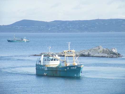
Dublin Bay. Photo Jehan Ashmore/ShipSNAPS
The vessels were making a southerly direction as they headed across Dublin Bay towards Dalkey Island. Mytilus lowered a mussel cage bucket into the sound which was dragged on two separate occasions over a short distance running parallel between the island and the coast.
The operation was all too brief as the Mytilus then proceeded into Killiney Bay followed closely astern by Branding. Upon entering the neighbouring bay, both vessels conducted dredging activity before continuing south beyond Bray Head.
Mussel grounds are located throughout certain hotspots in the Irish Sea and earlier this month, it is reported that there was a notable increase in mussel dredgers in Bangor, Northern Ireland. The dredgers were the Mytilus and Branding which berthed at the Co. Down harbour after a lengthy period of relative inactivity.
Mytilus was built in The Netherlands by Scheepwerf Van Os Yerseke B.V. and appeared in an episode of the successful BBC TV series 'Coast'. At the time of the broadcast she was registered at Beaumaris, Anglesey and was seen working in the northern approaches of the Menai Straits. The fishery grounds are ideally suited for the growing processes required in farmed mussel production.
Branding was also built by a Dutch shipyard, Kooieman in 1988 and her design is typical of the mussel dredgers based in Wexford. The market for mussels is mainly from the northern European countries of Belgium, France and the Netherlands.
- Dublin Bay
- Coast
- Marine Institute
- Northern Ireland
- naval service
- Dublin Bay News
- Anglesey
- Ports and Shipping News
- Island News
- RV Celtic Voyager
- TallShips
- RV Keary
- Geological Survey of Ireland
- GSI
- Mussel dredgers
- Mussel trawlers
- Mytilus
- Branding
- Dalkey Sound
- Fishery
- Menai Strait
- Beaumaris
- Banger
- Fish news
- BBC
- BBC TV series 'Coast'
- Belfastregistered
- Wexfordregistered
- Dutchbuilt
- Mussel markets
- Killiney Bay
- Bray Head


