


Displaying items by tag: RV Celtic Voyager
Marine Research Project Stays on Track Despite Pandemic
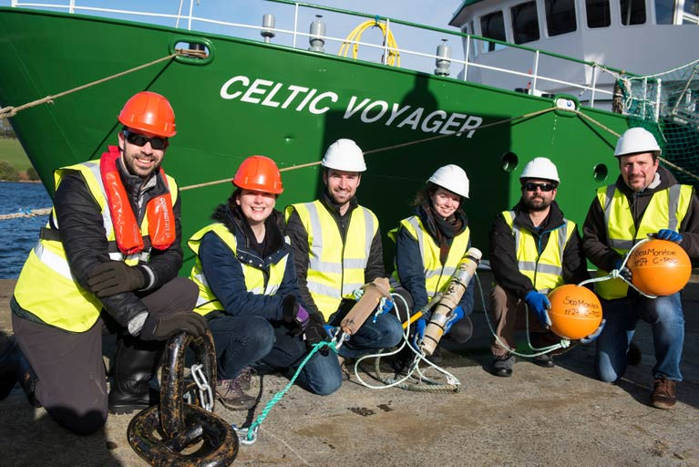
Important research that will help advance the management of our seas around Ireland, Western Scotland and Northern Ireland has not totally ceased during the coronavirus pandemic.
The SeaMonitor project, which is led by the Loughs Agency and supported by another eight leading marine science research institutions, was able to deploy some of its innovative species tracking technology to better understand and protect vulnerable marine life in our oceans.
Since April, following work on a tracking array at sea from the RV Celtic Voyager, scientists from across the partnership have managed to safely tag and release over 250 fish from five rivers in Ireland, Northern Ireland and Scotland with trackers.
The technology behind them, called acoustic telemetry, involves deploying a series of listening stations from Malin Head to the island of Islay in Scotland that will record transmissions from a variety of marine species tagged by the project’s scientists.
The data, which is due to be downloaded from the receivers in the autumn, will be used to support the conservation of a variety of vulnerable species such as salmon, basking sharks, skate, dolphins, whales and seals.
Funding for the SeaMonitor project to the tune of €4.7m has been provided under the environment objective of the European Union’s INTERREG VA Programme, which is managed by the Special EU Programmes Body (SEUPB).
Match-funding for this project has been provided by the Department for Agriculture, Environment and Rural Affairs in Northern Ireland and the Department of Housing, Planning and Local Government in Ireland.
Welcoming the deployment, Gina McIntyre, chief of the Special EU Programmes Body, said: “I’m delighted to see such significant achievements for the SeaMonitor project given the significant challenges faced by all involved.
“This is a much-needed step forward for the conservation of a number of vulnerable species within our shared oceans. It only serves to highlight the benefits that are created through strong, mutually beneficial cross-border partnerships in the management of marine protected areas and species. Well done to all involved for advancing our understanding of our seas.”
For more information about the project visit the Lough Agency’s SeaMonitor portal or follow the project on Twitter at @SeaMonitor1.
The Mobility of Sediment Waves and Sand Banks in the Irish Sea (MOVE) Survey will be carried out from Tuesday 31 March until Monday 13 April in the south Irish Sea, according to the latest Marine Notice from the Department of Transport, Tourism and Sport.
This survey is being carried out in support of ongoing research at the Irish Centre for Research in Applied Geosciences (iCRAG).
The survey will be carried out by the RV Celtic Voyager (callsign: EQIN) using a variety of equipment and techniques, including ADCP, multibeam sonar and sediment sampling.
Work will be performed on a 24 hour schedule and the vessel will display appropriate lights and signals.
Details of all works entailed and the survey area are included in Marine Notice No 12 of 2020, a PDF of which is available to read or download HERE.
Open Call For 22 Marine Research Vessel Bursaries In 2020

The Marine Institute in collaboration with the Strategic Marine Alliance for Research and Training (SMART) is offering 22 bursaries on dedicated FEAS surveys throughout 2020 on the RV Celtic Explorer and RV Celtic Voyager.
Bursaries include groundfish, acoustic and underwater TV surveys (UWTV) on 13 survey legs between February and December of this year on the shelf waters of the Irish EEZ.
Successful applicants will receive a Student at Sea Bursary at a fixed rate of €95 per survey night.
Participants will receive hands-on training in data collection and sampling techniques, be fully integrated into the survey work programme and make an important contribution to achieving the survey goals for marine science.
In so doing they will gain valuable sea going experience and assist the Marine Institute in building the necessary capacity for offshore research and monitoring.
Applicants should be marine-oriented graduates, postgraduates, researchers or practitioners in marine-oriented enterprises. They must hold current ENG11 medical and Personal Survival Techniques (PST STCW95) certificates, and should have some prior sea-going experience.
Further information on the available bursaries can be found on the SMART website, which also has details of the online application process.
Applications Open For EurofleetsPlus ‘Floating University’ In Cork Harbour
The EurofleetsPlus project is calling for applications from early-stage researchers of marine-related sciences to take part in a ‘Floating University’ on the RV Celtic Voyager next spring.
Applications are open until next Friday 22 November for the scheme co-ordinated in Ireland by the Marine Institute.
Mapping the Ocean Floor: An Introduction to Practical Aspects of Hydrographic Surveying will take place on board the RV Celtic Voyager in Cork Harbour from 19-25 February next year.
Teaching will focus on the operation of multi-beam echosounders and sub-bottom profiling and their applications for mapping and characterising the seabed. Offshore training will be supported by lectures, workshops and online resources.
On completion, participants of the Floating University will be able to demonstrate competence in designing and executing an offshore hydrographic survey, articulate understanding of the principles and methods applied to seabed surveying, as well as practice data acquisition and data processing for multi-beam echosounders and sub-bottom profiler systems.
Instruction will be from expert practitioners from the INFOMAR project with guest lecturers from the Marine Geology Research Group, University College Cork, and the National Institute of Oceanography and Applied Geophysics (OGS) in Italy.
A total of eight places are available for European postgraduate students (students of all nationalities enrolled at European universities) and online applications must be received by next Friday. Details of the Floating University and how to apply can be found HERE.
Herring Spawning Stock Survey Off West & North West Coasts This December

The Marine Institute’s Fisheries Ecosystems Advisory Services (FEAS) department will undertake a survey of herring off the West and North West Coasts from 1-10 December.
This survey is the fourth in a time series that is hoped will be developed into a long-term index of spawning/pre-spawning herring in ICES area 6a S/7b, for use in stock assessments in the future.
The overall 6a survey (6a N and 6a S/7b) is part of a collaborative partnership between Ireland, the Netherlands and UK (Scotland) that aims to improve understanding of the individual stock components of herring in 6a and 7b.
Next month’s survey will be conducted by the RV Celtic Voyager (callsign EIQN) using a towed body with two split-beam transducers (38 kHz and 120 kHz). The vessel will be trackable online during the survey.
In total around 1,100 nautical miles of cruise track will be undertaken with a mixture of parallel (spaced at 7.5 and 3.5 nm) and zig-zag transects. The vessel will display appropriate lights and signals.
Night operations will involve the towing of the two split-beam transducer. Fishing will take place opportunistically during daylight hours.
Contact details and co-ordinates of the relevant survey areas are included in Marine Notice No 50 of 2019, a PDF of which is available to read or download HERE.
Marine Notice: Geohazard Investigation In Irish Sea
A geohazard investigation to provide support for ongoing research at the Irish Centre for Research in Applied Geosciences (iCRAG) will be undertaken in the Irish Sea from Thursday 24 October until Wednesday 6 November, weather dependent.
The locations of these works at various shipwreck sites off the Louth coast are provided in Marine Notice No 41 of 2019. The equipment and techniques to be used include:
- Surveying using multibeam echo sounders and shallow seismics (pinger);
- Passive acoustic monitors (PAM) deployed at the indicated locations near the seabed to record acoustic data;
- Seismic sparker equipment to reveal subsurface structure and features;
- Sediment core taken at indicated locations to characterise the lithological characteristics of the seabed with grab samples taken within a 3nm range of these locations.
The surveys will be completed on a 24-hour schedule by the RV Celtic Voyager (callsign EIQN) which will display appropriate lights and signals.
Acoustic surveying using a multibeam echo sounder and seismic sub-bottom surveys using a sparker/pinger system will be performed during both day and night operations in accordance with safe operating practices regarding MMO procedures and cognisant of fishing gear.
Sediment sampling using cores will be carried out during daylight hours due to limited ship mobility. PAM units will be deployed and retrieved at both night and day as dictated by survey conditions.
Full details of the survey locations as well as contact information are included in Marine Notice No 41 of 2019, a PDF of which is available to read or download HERE.
Scientists & Students Voyage To 100m Contour To Study Ireland’s Top Marine Predators
The RV Celtic Voyager departed early this morning (Thursday 1 August) from the Port of Cork on a multidisciplinary marine wildlife survey investigating the biological and oceanographic features of the 100m contour line between Cork to Galway.
The survey team comprises scientists and students from the Irish Whale and Dolphin Group (IWDG), Galway-Mayo Institute of Technology’s Marine and Freshwater Research Centre and NUI Galway’s Department of Earth and Ocean Sciences.
And they are hoping to learn more about what’s an apparent biodiversity hotspot, attracting the top marine predators in Irish waters from large predatory fish to seabirds and cetaceans.
Inspiration for the survey came from the regular occurrence of humpback whales observed near the 100m depth contour line, especially off West Kerry, and the team hopes to learn if this is consistent along the whole contour.
During the survey, which can be followed at the Scientists@Sea blog, visual survey teams will record marine mammals and seabirds from the deck, and a hydrophone will be towed to record any vocalising whales and dolphins.
Physical oceanography will be recorded through CTD casts along six east-west transects during the night. If fish marks coincide with concentrations of marine predators, it’s hoped they will reveal what species are feeding and what they’re feeding on.
This survey also contributes to the IWDG’s WhaleTrack Ireland project, funded by Ryanair through its Carbon Carbon Offset Programme.

Scientists and students at NUI Galway’s Ryan Institute enjoyed a day trip on the Marine Institute’s research vessel RV Celtic Voyager on Friday (21 June) to take part in Ocean Sampling Day 2019.
Ocean Sampling Day is a simultaneous sampling campaign of the world’s oceans by scientists globally. It is organised by an EU consortium of marine research institutes, known as ASSEMBLE Plus, of which NUI Galway’s Ryan Institute is a partner.
Chief scientist Prof Louise Allcock, who is director of the Centre for Ocean Research and Exploration within the Ryan Institute, led a team of four experienced scientists and 11 marine science undergraduates who are in the first to third year of their studies.
Prof Allcock said: “We will sample and filter water from the ocean, and our filter papers, as well as those from other sites around the world, which will be sent to a molecular lab in a marine station in Greece where all the DNA on the filter papers will be sequenced to give an estimate of what bacterial and invertebrate species are present in the ocean.
“A healthy ocean has a wide variety of species, an unhealthy ocean less so — and hence we get an overview of our ocean health."
Sheena Fennell, one of the experienced scientists in the team who has spent extensive time at sea, explained the benefits to the undergraduate students joining the expedition.
“The students learn in their lectures all about the water column, the bacteria and invertebrates living therein, and the specialised gears that we use to sample, but this is an opportunity for them to get genuine hands-on experience while contributing to an international research project.”
The science team sampled directly above the SmartBay SubSea Cabled Observatory in Galway Bay.
Prof Allcock spoke of the importance of this site to the project: “The SmartBay Observatory provides subsea data all year round which means there is an enormous environmental dataset to complement our physical samples.
“Taking our samples from here also affords us the opportunity to highlight this impressive infrastructure to our European colleagues.”
The Marine Institute is also entertaining a group of third-level students as part of the 2019 Summer Bursary Programme.
Coming from a variety of disciplines across seven academic institutions, the students will gain experience in various fields of marine science including marine fisheries, aquaculture, communications, archiving, ecology, chemistry and catchment research in placements running between eight and 12 weeks.
“The work experience programme enables students from a wide variety of disciplines to further their knowledge and research in their particular area of interest,” said Helen McCormick, programme co-ordinator and senior laboratory analyst at the Marine Institute.
“It also offers students the opportunity to expand their professional networks, by meeting fellow students from other universities as well as work with experts in the their field and across the marine sector.
"Previous bursars have gained various positions within the Marine Institute at all grades up to and including director level.”
While many of the bursars will be based in the laboratories and offices at the Marine Institute’s headquarters in Oranmore, some students are also stationed at the catchment research facility in Newport, Co Mayo, where they will work with salmonids and eels, while others will be based in Castletownbere, Co Cork sampling fish and shellfish catches.
A number also took part in SeaFest 2019, Ireland’s national maritime festival, which took place from 7-9 June in Cork.
The first in a series of hydrographic and geophysical surveys to be undertaken in the Celtic Sea and Atlantic Ocean under the INFOMAR programme between April and October 2019 is now under way.
The RV Celtic Voyager (callsign EIQN) set off on Friday 12 April for an 18-day survey, the first of four over the next five months 18 May-6 June, 12-28 July, 29 August-14 September).
The RV Celtic Explorer (callsign EIGB) will follow up with an 18-day survey from 21 September to 8 October. Both vessels will be towing a magnetometer sensor with a single cable of up to 200 metres in length.
Other survey vessel involved include the Geological Survey Ireland vessels RV Keary (callsign EI-GO-9), RV Geo (callsign EI-DK-6), RV Mallet (callsign EI-SN-9) and RV Lir (callsign EI-HI-2).
All will display appropriate lights and markers and will be listening on VHF Channel 16 throughout the course of the surveys.
Full details of the survey areas are included in Marine Notice No 8 of 2019, a PDF of which is available to read or download HERE.
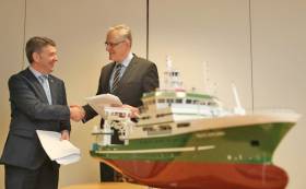
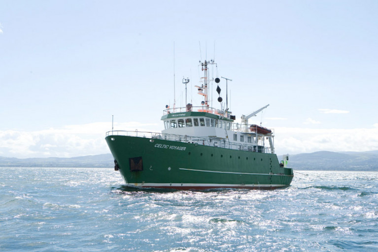
#MarineScience - Ship design consultants Skipsteknisk AS of Ålesund, Norway have been awarded the contract to design the new state-of-the-art marine research vessel for Ireland.
The new 50m research vessel due in 2022 will replace the RV Celtic Voyager and will be a sister ship to Ireland’s largest research vessel, the 65m RV Celtic Explorer.
It will also form a critical part of the State’s maritime infrastructure, supporting the Government’s national integrated marine plan, Harnessing Our Ocean Wealth, as well as the National Marine Research and Innovation Strategy.
In the more immediate term, the new vessel will help address research challenges resulting from Brexit and the Common Fisheries Policy, as well as climate-induced impact on the oceans.
“There are many challenges posed and threats in relation to our oceans and research is an intrinsic part of formulating a sustainable approach to the use, understanding and management of our oceans,” said Marine Minister Michael Creed.
“The funding of the new vessel demonstrates the Government’s commitment to expanding and strengthening marine science in Ireland to ensure our nation is equipped with the best scientific advice possible to enable a strong negotiating position and to maximise economic opportunities in a sustainable manner.”
Dr Peter Heffernan, chief executive of the Marine Institute, welcomed the signing of the research vessel design contract following an extensive EU tender process.
“The institute is on track and on budget with the design of the new vessel, which will provide critical national infrastructure and marks a major milestone in the Marine Institute's efforts to provide world-class marine science.
“The significantly enhanced capabilities of the new research vessel will help researchers, educators, students and the public gain a richer understanding of our ocean and will facilitate exploration that will lead to discoveries that stretch the bounds of our imagination.
Dr Heffernan added that “this significant investment in the nation’s scientific research recognises the Marine Institute's quarter-century of leadership in the field of oceanography and its long-standing and fruitful collaborations with partner institutions.
“The new vessel will enable us all to more efficiently explore, collaborate, and conduct global ocean research.”
Based in Galway, the vessel will be used by the Marine Institute and other State agencies and universities to undertake fisheries research, seabed mapping, oceanographic and environmental research and surveys, as well as student training.
It will also allow for continued transatlantic surveys with international partners through the Atlantic Ocean Research Alliance (AORA) and EU funded-survey programmes obtained through Horizon 2020.
Skipsteknisk AS are specialists in the design of highly advanced ships and are recognised internationally as leading designers in the research, fishing and offshore sectors.
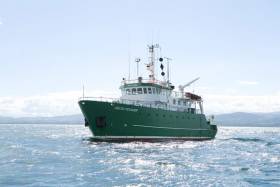
The nature of marine equipment has changed significantly since the launch of Ireland’s first research vessel, the RV Celtic Voyager back in 1997
That’s according to Mick Gillooly, director of ocean science and information services with the Marine Institute.
“The new research vessel will be 50m long and will feature state-of-the-art technologies enabling a wide range of work including ocean monitoring, fish stock assessment and seabed surveying. This new vessel will be a silent research vessel, and will be designed to meet the stringent criteria of the ICES 209 noise standard for fisheries research.
“In addition, the vessel will be designed to operate in the harsh conditions encountered in the NE Atlantic and will be able to spend 21 days at sea. It will also support the remotely operated vehicle (ROV) and autonomous underwater vehicle operations, which enable the exploration of our deep ocean down to 3,000m.”
Once the design phase is complete, the next phase is to tender for a shipyard to construct the vessel. This is expected to be complete by the end of this year, with delivery of the new vessel expected in early 2022.


 as lead helm, rounds the Fastnet Rock on the way to the overall win in 1987")


