Menu

Ireland's sailing, boating & maritime magazine

Dublin & its Port Have Always Been Inter-linked & Developing Together

7th October 2020
The city of river and sea. Modern Dublin and its port looking eastward The city of river and sea. Modern Dublin and its port looking eastward Credit: Irish Air Corps

If you were asked to name the real centre point of modern Dublin, you'd probably dodge the question by saying that it's somewhere along a line through O'Connell Bridge and Trinity College, and on up Grafton Street or Dawson Street. Either way, that would definitely be locating the city's contemporary focus. Yet four hundred years ago, this modern central axis would have been regarded as being out in the sticks, down in the marshy inner edges of Dublin Bay.

When Trinity College was founded in 1592, its official title described it as being "Near Dublin". It was clearly eastward of the significant mediaeval city walls by slightly less than a mile, and eastward too of the main port area on the River Liffey, which was still centred around what had been the Dubh Linn, the "black pool" much favoured as a berth by the Viking's ships when they set up the makings of a settlement which first achieved some sort of civic status in 841.

Herman Moll's map of 1714Dublin as it was when the book begins, as recorded by Herman Moll's map of 1714. Trinity College is shown as "near Dublin", while building on the north side of the new St Stephens Green has only recently begun. When development of the south side of what was to become Merrion Square was started close to the east of Stephen's Green, a selling point for the new Georgian houses was their "refreshing sea view".

The central location around what had become Dublin Castle remained the heart of town for centuries. But while there was gradual expansion in every direction with the northsider/southsider psychological divide across the Liffey seeming to arise almost immediately – basically it was the Ostmen (the Eastmen or Danes) to the Northside, Normans on the Southside - the real engine of the city's power was always inclined to move eastward.

In his mighty yet very readable tome Dublin Moving East 1708-1844 – How the City took over the Sea, sailor/historian Michael Branagan has set in context the process whereby Trinity College and its environs have become the heart of the city through the machination of urban and port development, such that the main port area has undergone a major shift over the centuries, and is now well to the east of the College. So much so, in fact, that the entire estate of Dublin Port – one of the sponsors of this book - is on land which simply didn't exist when the "College of the Holy and Undivided Trinity" came into being.

The word that is generally used for this land is "reclaimed", as though the nefarious sea had originally pinched it from the decent people of Dublin while they were asleep. Nowadays, with global sea levels rising, how it's described may well become academic. But there is no doubt that - back in the era on which the book focuses - there was some extraordinarily effective land-grabbing going on in Dublin at the sea's expense.

The outcome is the shape of the city as we know it today, much of which results from buccaneering land "reclamation" and inspired development by some extremely determined and occasionally roughshod people whose wealthy descendants became the very souls of civic respectability.

Michael Branagan is a real terrier when it comes to research, and the numerous footnotes to each chapter will lead the enquiring reader along many fascinating pathways of unusual information. Thus it makes for ideal lockdown reading, and if you permit yourself one chapter every two days, there's a month of absorbing and informative reading here. At the end of it, Dublin and its port will never seem quite the same again, and it will certainly seem even more interesting.

Dublin as it was around 1850A city transformed in 140 years - Dublin as it was around 1850. It was still much smaller than it is today, but the basic work had been done – often with very primate equipment – to create the basic structure for a city moving east.

In fact, those who care about Dublin remaining a vibrant port should see this book as required reading, and clearly one of those who care about the port beyond the call of duty is Eamonn O'Reilly, Chief Executive of Dublin Port Company, whose thoughtful foreword is much more than the usual politely token introduction, as it gives us further insights into an extraordinary and pioneering city/port system.

In its entirety, the book gives a sense of deeper understanding of why Dublin should continue to embrace its commercial port, rather than becoming some sort of synthetic skyscraper city, with the real working maritime heart torn out of it for re-location to some soul-less container terminal landing pier in the middle of nowhere.

It has taken a lot to make Dublin the special and unique place it is. Suggesting that the port activities should be moved elsewhere "because that's what they do in other capital cities" is a very lame argument indeed. Dublin is Dublin, and rightly or wrongly in this remarkable place beside its bay between the mountains and the sea, we do things our own way - and our way includes having ships and city in dynamic interaction. Michael Branagan has done everyone a great service in detailing the key years in which a primitive river haven was launched – with the use of some very primitive equipment – towards the transformed situation where it was ready to become the fascinating port city that we know today.

Dublin and its port and bay today
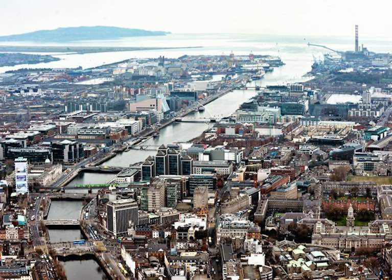
Dublin and its port and bay today. While much of the channelled River Liffey in the port has been planned, a very welcome unintended consequence of the building of the South Bull Wall - accelerated by the addition of the North Bull – has been the natural development of the extensive nature reserve of Bull Island in the north of Dublin Bay, created by wind-driven sand augmented by tide-carried silt. This photo also emphasizes the very special role of Dun Laoghaire as virtually the sole access point to Dublin Bay as a waterborne sports and leisure amenity for the large population of South Dublin

Dublin Moving East 1708-1844

By Michael Branagan
320 pp, fully illustrated
Published by Wordwell, €35.

WM Nixon

About The Author

WM Nixon

Email The Author

William M Nixon has been writing about sailing in Ireland for many years in print and online, and his work has appeared internationally in magazines and books. His own experience ranges from club sailing to international offshore events, and he has cruised extensively under sail, often in his own boats which have ranged in size from an 11ft dinghy to a 35ft cruiser-racer. He has also been involved in the administration of several sailing organisations.

We've got a favour to ask

More people are reading Afloat.ie than ever thanks to the power of the internet but we're in stormy seas because advertising revenues across the media are falling fast. Unlike many news sites, we haven't put up a paywall because we want to keep our marine journalism open.

Afloat.ie is Ireland's only full-time marine journalism team and it takes time, money and hard work to produce our content.

So you can see why we need to ask for your help.

If everyone chipped in, we can enhance our coverage and our future would be more secure. You can help us through a small donation. Thank you.

Direct Donation to Afloat button

About Dublin Port 

Dublin Port is Ireland’s largest and busiest port with approximately 17,000 vessel movements per year. As well as being the country’s largest port, Dublin Port has the highest rate of growth and, in the seven years to 2019, total cargo volumes grew by 36.1%.

The vision of Dublin Port Company is to have the required capacity to service the needs of its customers and the wider economy safely, efficiently and sustainably. Dublin Port will integrate with the City by enhancing the natural and built environments. The Port is being developed in line with Masterplan 2040.

Dublin Port Company is currently investing about €277 million on its Alexandra Basin Redevelopment (ABR), which is due to be complete by 2021. The redevelopment will improve the port's capacity for large ships by deepening and lengthening 3km of its 7km of berths. The ABR is part of a €1bn capital programme up to 2028, which will also include initial work on the Dublin Port’s MP2 Project - a major capital development project proposal for works within the existing port lands in the northeastern part of the port.

Dublin Port has also recently secured planning approval for the development of the next phase of its inland port near Dublin Airport. The latest stage of the inland port will include a site with the capacity to store more than 2,000 shipping containers and infrastructures such as an ESB substation, an office building and gantry crane.

Dublin Port Company recently submitted a planning application for a €320 million project that aims to provide significant additional capacity at the facility within the port in order to cope with increases in trade up to 2040. The scheme will see a new roll-on/roll-off jetty built to handle ferries of up to 240 metres in length, as well as the redevelopment of an oil berth into a deep-water container berth.

Dublin Port FAQ

Dublin was little more than a monastic settlement until the Norse invasion in the 8th and 9th centuries when they selected the Liffey Estuary as their point of entry to the country as it provided relatively easy access to the central plains of Ireland. Trading with England and Europe followed which required port facilities, so the development of Dublin Port is inextricably linked to the development of Dublin City, so it is fair to say the origins of the Port go back over one thousand years. As a result, the modern organisation Dublin Port has a long and remarkable history, dating back over 300 years from 1707.

The original Port of Dublin was situated upriver, a few miles from its current location near the modern Civic Offices at Wood Quay and close to Christchurch Cathedral. The Port remained close to that area until the new Custom House opened in the 1790s. In medieval times Dublin shipped cattle hides to Britain and the continent, and the returning ships carried wine, pottery and other goods.

510 acres. The modern Dublin Port is located either side of the River Liffey, out to its mouth. On the north side of the river, the central part (205 hectares or 510 acres) of the Port lies at the end of East Wall and North Wall, from Alexandra Quay.

Dublin Port Company is a State-owned commercial company responsible for operating and developing Dublin Port.

Dublin Port Company is a self-financing, and profitable private limited company wholly-owned by the State, whose business is to manage Dublin Port, Ireland's premier Port. Established as a corporate entity in 1997, Dublin Port Company is responsible for the management, control, operation and development of the Port.

Captain William Bligh (of Mutiny of the Bounty fame) was a visitor to Dublin in 1800, and his visit to the capital had a lasting effect on the Port. Bligh's study of the currents in Dublin Bay provided the basis for the construction of the North Wall. This undertaking led to the growth of Bull Island to its present size.

Yes. Dublin Port is the largest freight and passenger port in Ireland. It handles almost 50% of all trade in the Republic of Ireland.

All cargo handling activities being carried out by private sector companies operating in intensely competitive markets within the Port. Dublin Port Company provides world-class facilities, services, accommodation and lands in the harbour for ships, goods and passengers.

Eamonn O'Reilly is the Dublin Port Chief Executive.

Capt. Michael McKenna is the Dublin Port Harbour Master

In 2019, 1,949,229 people came through the Port.

In 2019, there were 158 cruise liner visits.

In 2019, 9.4 million gross tonnes of exports were handled by Dublin Port.

In 2019, there were 7,898 ship arrivals.

In 2019, there was a gross tonnage of 38.1 million.

In 2019, there were 559,506 tourist vehicles.

There were 98,897 lorries in 2019

Boats can navigate the River Liffey into Dublin by using the navigational guidelines. Find the guidelines on this page here.

VHF channel 12. Commercial vessels using Dublin Port or Dun Laoghaire Port typically have a qualified pilot or certified master with proven local knowledge on board. They "listen out" on VHF channel 12 when in Dublin Port's jurisdiction.

A Dublin Bay webcam showing the south of the Bay at Dun Laoghaire and a distant view of Dublin Port Shipping is here
Dublin Port is creating a distributed museum on its lands in Dublin City.
 A Liffey Tolka Project cycle and pedestrian way is the key to link the elements of this distributed museum together.  The distributed museum starts at the Diving Bell and, over the course of 6.3km, will give Dubliners a real sense of the City, the Port and the Bay.  For visitors, it will be a unique eye-opening stroll and vista through and alongside one of Europe’s busiest ports:  Diving Bell along Sir John Rogerson’s Quay over the Samuel Beckett Bridge, past the Scherzer Bridge and down the North Wall Quay campshire to Berth 18 - 1.2 km.   Liffey Tolka Project - Tree-lined pedestrian and cycle route between the River Liffey and the Tolka Estuary - 1.4 km with a 300-metre spur along Alexandra Road to The Pumphouse (to be completed by Q1 2021) and another 200 metres to The Flour Mill.   Tolka Estuary Greenway - Construction of Phase 1 (1.9 km) starts in December 2020 and will be completed by Spring 2022.  Phase 2 (1.3 km) will be delivered within the following five years.  The Pumphouse is a heritage zone being created as part of the Alexandra Basin Redevelopment Project.  The first phase of 1.6 acres will be completed in early 2021 and will include historical port equipment and buildings and a large open space for exhibitions and performances.  It will be expanded in a subsequent phase to incorporate the Victorian Graving Dock No. 1 which will be excavated and revealed. 
 The largest component of the distributed museum will be The Flour Mill.  This involves the redevelopment of the former Odlums Flour Mill on Alexandra Road based on a masterplan completed by Grafton Architects to provide a mix of port operational uses, a National Maritime Archive, two 300 seat performance venues, working and studio spaces for artists and exhibition spaces.   The Flour Mill will be developed in stages over the remaining twenty years of Masterplan 2040 alongside major port infrastructure projects.

Source: Dublin Port Company ©Afloat 2020.