Displaying items by tag: oil and gas exploration
Ban on New Oil & Natural Gas Exploration to be Introduced
The Minister for the Environment, Climate and Communications, Eamon Ryan TD, has obtained Cabinet approval to introduce legislation to ban licences for new oil and natural gas exploration. The legislation will be included in the Climate Action and Low Carbon Amendment Bill which will go before the Oireachtas shortly.
Today’s decision will ensure legislative effect is given to the commitment in the Programme for Government to end the issuing of new licences for the exploration and extraction of gas, on the same basis as the 2019 decision in relation to oil exploration and extraction. The Minister gave effect to this commitment immediately; the Department no longer accepts new applications for exploration licences for natural gas or oil, nor will there be any future licensing rounds. The legislation will involve amendments to the Petroleum and Other Minerals Development Act 1960, which is the legislation governing the issuing of petroleum authorisations in the Irish offshore.
Minister Ryan commented: “The decision we have made today to legislate for a ban on new oil exploration and extraction will send a powerful message, within Ireland and internationally, that Ireland is moving away from fossil fuels towards a renewable future. By keeping fossil fuels in the ground, we will incentivise the transition to renewable energy and put ourselves on a pathway to net zero by 2050. The previously announced prohibition on exploration for oil has had a welcome impact in terms of the numbers of existing authorisations that have been relinquished. I expect this number to reduce further in the period ahead given the increasingly challenging global investment environment for fossil fuels.”
The legislative amendments will not affect existing authorisations, with applications for authorisations and activities remaining subject to technical, financial and environmental assessments as appropriate.
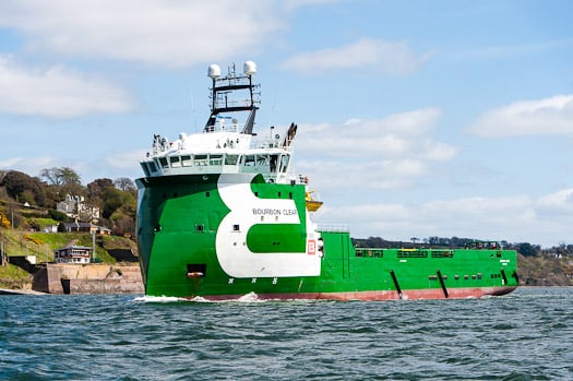
#CorkHarbour – The increasing strategic importance of Cork Harbour as a base for the oil and gas energy sector in the search for natural resources particularly off our southern shores, is evident with this recent view taken by our colleagues of the platform supply vessel (PSV) Bourbon Clear passing Cobh, writes Jehan Ashmore.
Not only is Bourbon Clear painted with a distinctive green hull but also features an unconventional bow which is of the X-BOW design, a unique and environmentally-friendly hull line design that is patented by her Norwegian developers Ulstein.
The odd looking X-Bow has an inverted bow design which was first introduced in 2005 with the Bourbon Orca, her introduction caused quite a splash in the offshore maritime world and beyond.
Since then, more 60 vessels of various designs have been completed with the specialist bow form which claims to improve handling in rough seas and in reduced levels of fuel consumption.
The 4,000 tonnes newbuild has further Nordic connections as the owners are Bourbon Offshore Norway. The company have a fleet of vessels that utilizise in the very latest design and technology so to provide supplies to oil and oil-related companies all over the world.

Bourbon Clear passes Port Control at 'The Holy Ground' area of Cork Harbour. Photo: Bob Bateman
Currently Bourbon have newbuilds under construction and they are of the Ulstein PX105 PSV design in which the 80m Bourbon Clear belongs to this series having been launched last year from a Chinese shipyard.
Bourbon Clear has called previously to Cobh Cruise Terminal and in the background of the (TOP) photo, is yet another Norwegian flagged vessel, Hurtigruten's Fram, the polar expedition cruiseship which visited Dublin Port yesterday.
Oil Strike Success Off Cork Coast Could Be Worth Billions
#COASTAL NOTES - Providence Resources has struck big off the south coast of Cork with an oil flow that could be worth billions of euro to the beleaguered Irish economy.
According to the Guardian, the Dublin-based company announced yesterday that oil had started to flow successfully from its Barryroe structure in the north Celtic Sea at nearly twice the rate previously projected.
Providence Resources CEO Tony O'Reilly Jr said the discovery was a "seminal day for Ireland, especially in the runup to St Patrick's Day."
Last month the firm had confirmed the presence of light oil with its first appraisal well at the site, a situation described by its technical director as "extremely encouraging".
Now that a steady flow has been achieved, future extraction from the oil field - comparable to a medium-to-large North Sea field - can surely proceed, which now puts pressure on the Government to grand permission for further exploration around the Irish coast.
As previously reported on Afloat.ie, plans by Providence Rescources to prospect for oil on the east coast off Dalkey Island have been met with fierce opposition by mainland residents and environmental groups.
The Guardian has much more on the story HERE.


