Menu

Ireland's sailing, boating & maritime magazine

Dublin Bay Boating News and Information

Displaying items by tag: Wilson Tana

The ro-ro freight-ferry Norcape departed Dublin Port this evening for what is believed to be her last sailing operating under the colours of P&O (Irish Sea) and in which the 1979 built vessel originally served a career with B+I Line as the Tipperary, writes Jehan Ashmore.
Replacing the 14,087gross tonnes vessel is the 22,152grt ro-pax European Endeavour which is expected to enter service next Tuesday. The vessel built in 2000, can take 130 lorries and has a larger passenger capacity for 210 passengers compared to the existing route's 17,464grt ro-pax sisters Norbay and Norbank.

This will enable P&O to offer up to three Ro-Pax style sailings a day on the 7.5 hour route instead of the previous two-plus one ro-ro (freight-only operated) service. The Norcape could take 125 drop trailers but only had 12-passenger cabins (for freight accompanied truck-drivers).

Norcape was only re-introduced onto the Irish Sea last year but made her final departure tonight as the vessel headed into a foggy Dublin Bay.

In 1979 the Japanese built vessel was launched as the Puma for P&O but was chartered to B+I Line and renamed Tipperary. During the 1980's the vessel first operated a then new Dublin-Fleetwood route jointly operated with P&O, alongside Tipperary's Ro-Ro sister, Ibex. The P&O brand name Pandoro cleverly stood for P and O Ro, their roll-on roll-off freight division. 

TIPPERARY

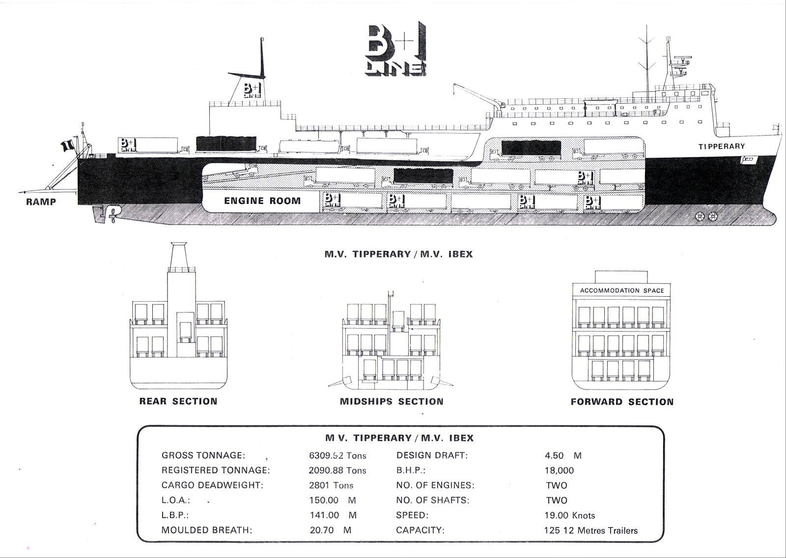
Cut-away deck profile of M.V. Tipperary and sistership of M.V. Ibex

The route's UK port switched to Liverpool in 1988 with Tipperary remaining on the route until sold to North Sea Ferries in 1989 and renamed Norcape. Prior to her transfer to the North Sea, the Tipperary collided with the 4,674grt bulker Sumburgh Head off the entrance to Dublin Port on 18 February 1988. For a report and photo taken of the two vessels which met at the port last year under different names click here.

Like the Tipperary the Sumburgh Head was built in Japan too by Hashihama Zosen KK, Imabari in 1977, yard no. 624. During her Dublin Bay incident, the vessel was owned by Christian Salvesen (Shipping) Ltd based in Edinburgh.

In 1990 she was sold to Barra Head Shipping Ltd and renamed Hood Head under the Irish flag. Three years later sold again to the KG Jebsen group and renamed Husnes.

The Panamanian flagged bulker remained with the Norwegian owner until 2003 when sold to her current owners, Wilson Shipowning AS of Bergen and renamed Wilson Tana, this time under the Maltese flag.

Published in Ferry

Dublin Bay

Dublin Bay on the east coast of Ireland stretches over seven kilometres, from Howth Head on its northern tip to Dalkey Island in the south. It's a place most Dubliners simply take for granted, and one of the capital's least visited places. But there's more going on out there than you'd imagine.

The biggest boating centre is at Dun Laoghaire Harbour on the Bay's south shore that is home to over 1,500 pleasure craft, four waterfront yacht clubs and Ireland's largest marina.

The bay is rather shallow with many sandbanks and rocky outcrops, and was notorious in the past for shipwrecks, especially when the wind was from the east. Until modern times, many ships and their passengers were lost along the treacherous coastline from Howth to Dun Laoghaire, less than a kilometre from shore.

The Bay is a C-shaped inlet of the Irish Sea and is about 10 kilometres wide along its north-south base, and 7 km in length to its apex at the centre of the city of Dublin; stretching from Howth Head in the north to Dalkey Point in the south. North Bull Island is situated in the northwest part of the bay, where one of two major inshore sandbanks lie, and features a 5 km long sandy beach, Dollymount Strand, fronting an internationally recognised wildfowl reserve. Many of the rivers of Dublin reach the Irish Sea at Dublin Bay: the River Liffey, with the River Dodder flow received less than 1 km inland, River Tolka, and various smaller rivers and streams.

Dublin Bay FAQs

There are approximately ten beaches and bathing spots around Dublin Bay: Dollymount Strand; Forty Foot Bathing Place; Half Moon bathing spot; Merrion Strand; Bull Wall; Sandycove Beach; Sandymount Strand; Seapoint; Shelley Banks; Sutton, Burrow Beach

There are slipways on the north side of Dublin Bay at Clontarf, Sutton and on the southside at Dun Laoghaire Harbour, and in Dalkey at Coliemore and Bulloch Harbours.

Dublin Bay is administered by a number of Government Departments, three local authorities and several statutory agencies. Dublin Port Company is in charge of navigation on the Bay.

Dublin Bay is approximately 70 sq kilometres or 7,000 hectares. The Bay is about 10 kilometres wide along its north-south base, and seven km in length east-west to its peak at the centre of the city of Dublin; stretching from Howth Head in the north to Dalkey Point in the south.

Dun Laoghaire Harbour on the southside of the Bay has an East and West Pier, each one kilometre long; this is one of the largest human-made harbours in the world. There also piers or walls at the entrance to the River Liffey at Dublin city known as the Great North and South Walls. Other harbours on the Bay include Bulloch Harbour and Coliemore Harbours both at Dalkey.

There are two marinas on Dublin Bay. Ireland's largest marina with over 800 berths is on the southern shore at Dun Laoghaire Harbour. The other is at Poolbeg Yacht and Boat Club on the River Liffey close to Dublin City.

Car and passenger Ferries operate from Dublin Port to the UK, Isle of Man and France. A passenger ferry operates from Dun Laoghaire Harbour to Howth as well as providing tourist voyages around the bay.

Dublin Bay has two Islands. Bull Island at Clontarf and Dalkey Island on the southern shore of the Bay.

The River Liffey flows through Dublin city and into the Bay. Its tributaries include the River Dodder, the River Poddle and the River Camac.

Dollymount, Burrow and Seapoint beaches

Approximately 1,500 boats from small dinghies to motorboats to ocean-going yachts. The vast majority, over 1,000, are moored at Dun Laoghaire Harbour which is Ireland's boating capital.

In 1981, UNESCO recognised the importance of Dublin Bay by designating North Bull Island as a Biosphere because of its rare and internationally important habitats and species of wildlife. To support sustainable development, UNESCO’s concept of a Biosphere has evolved to include not just areas of ecological value but also the areas around them and the communities that live and work within these areas. There have since been additional international and national designations, covering much of Dublin Bay, to ensure the protection of its water quality and biodiversity. To fulfil these broader management aims for the ecosystem, the Biosphere was expanded in 2015. The Biosphere now covers Dublin Bay, reflecting its significant environmental, economic, cultural and tourism importance, and extends to over 300km² to include the bay, the shore and nearby residential areas.

On the Southside at Dun Laoghaire, there is the National Yacht Club, Royal St. George Yacht Club, Royal Irish Yacht Club and Dun Laoghaire Motor Yacht Club as well as Dublin Bay Sailing Club. In the city centre, there is Poolbeg Yacht and Boat Club. On the Northside of Dublin, there is Clontarf Yacht and Boat Club and Sutton Dinghy Club. While not on Dublin Bay, Howth Yacht Club is the major north Dublin Sailing centre.

© Afloat 2020