Menu

Ireland's sailing, boating & maritime magazine

Dublin Bay Boating News and Information

Displaying items by tag: Cromane

Marine Minister Charlie McConalogue has continued his series of visits to some of Ireland’s main fishing ports, spending yesterday and today (Thursday 16 and Friday 17 September) in Co Kerry.

The minister met with fishers, fishing organisations and other stakeholders as he visited the ports of Dingle, Fenit and Cromane.

These visits follow on from the minister’s trips during the summer to Howth, Kilmore Quay, Dunmore East, Killybegs, Union Hall and Castletownbere.

In Fenit, the minister met with local fishers to discuss fishing matters. The Marine Institute and local stakeholders updated on conservation initiatives and measures for crayfish along the Co Kerry coastline and outlined protection measures for angel shark, skates and rays, particularly in the Tralee Bay area.

A public consultation on the crayfish fishery was launched last month to gather views on measures targeted at eliminating the by-catch of endangered species while seeking to secure a viable and sustainable future for the fishery. The consultation concluded yesterday.

Later the minister visited Dingle Fishery Harbour Centre and met the harbour master. Since 2010, €17.4 million has been invested in the development and maintenance of Dingle FHC under the Department of Agriculture, Food and the Marine’s Fishery Harbour and Coastal Infrastructure Capital Programme.

In Dingle, the minister also met with local fishers and representatives of the seafood and broader marine sector including the Dingle Innovation Hub and the Dingle Aquarium.

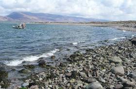
In Cromane, the minster met with, and heard the views of the local community regarding a landing facility.

Commenting on the visits, Minister McConalogue said: “I have had constructive meetings with fishers, aquaculture farmers and other stakeholders during my visit to Kerry today, and I thank everyone for meeting me to discuss matters important to their communities.

“It is a great opportunity for me to hear directly from marine stakeholders who are central in ensuring the long-term vibrancy of our coastal communities.”

Published in Fishing
Tagged under

#Kerry - RTÉ News reports that a kayaker drowned off the Iveagh Peninsula in Co Kerry yesterday afternoon, Friday 10 August.

Emergency services were alerted around 2.30pm to Cromane after the kayaker had been recovered from the water by a local fisherman who attempted CPR, but the casualty was pronounced dead at the scene.

Published in News Update

#NEWS UPDATE - Breaking News reports that the search for a 38-year-old man who went kayaking near Cromane in Co Kerry in the early hours of yesterday will resume this morning.

The alarm was raised yesterday morning after the man - named locally as Nealie O'Connor, and the father of a two-month-old baby - failed to return from his lake kayaking trip.

Published in News Update

Dublin Bay

Dublin Bay on the east coast of Ireland stretches over seven kilometres, from Howth Head on its northern tip to Dalkey Island in the south. It's a place most Dubliners simply take for granted, and one of the capital's least visited places. But there's more going on out there than you'd imagine.

The biggest boating centre is at Dun Laoghaire Harbour on the Bay's south shore that is home to over 1,500 pleasure craft, four waterfront yacht clubs and Ireland's largest marina.

The bay is rather shallow with many sandbanks and rocky outcrops, and was notorious in the past for shipwrecks, especially when the wind was from the east. Until modern times, many ships and their passengers were lost along the treacherous coastline from Howth to Dun Laoghaire, less than a kilometre from shore.

The Bay is a C-shaped inlet of the Irish Sea and is about 10 kilometres wide along its north-south base, and 7 km in length to its apex at the centre of the city of Dublin; stretching from Howth Head in the north to Dalkey Point in the south. North Bull Island is situated in the northwest part of the bay, where one of two major inshore sandbanks lie, and features a 5 km long sandy beach, Dollymount Strand, fronting an internationally recognised wildfowl reserve. Many of the rivers of Dublin reach the Irish Sea at Dublin Bay: the River Liffey, with the River Dodder flow received less than 1 km inland, River Tolka, and various smaller rivers and streams.

Dublin Bay FAQs

There are approximately ten beaches and bathing spots around Dublin Bay: Dollymount Strand; Forty Foot Bathing Place; Half Moon bathing spot; Merrion Strand; Bull Wall; Sandycove Beach; Sandymount Strand; Seapoint; Shelley Banks; Sutton, Burrow Beach

There are slipways on the north side of Dublin Bay at Clontarf, Sutton and on the southside at Dun Laoghaire Harbour, and in Dalkey at Coliemore and Bulloch Harbours.

Dublin Bay is administered by a number of Government Departments, three local authorities and several statutory agencies. Dublin Port Company is in charge of navigation on the Bay.

Dublin Bay is approximately 70 sq kilometres or 7,000 hectares. The Bay is about 10 kilometres wide along its north-south base, and seven km in length east-west to its peak at the centre of the city of Dublin; stretching from Howth Head in the north to Dalkey Point in the south.

Dun Laoghaire Harbour on the southside of the Bay has an East and West Pier, each one kilometre long; this is one of the largest human-made harbours in the world. There also piers or walls at the entrance to the River Liffey at Dublin city known as the Great North and South Walls. Other harbours on the Bay include Bulloch Harbour and Coliemore Harbours both at Dalkey.

There are two marinas on Dublin Bay. Ireland's largest marina with over 800 berths is on the southern shore at Dun Laoghaire Harbour. The other is at Poolbeg Yacht and Boat Club on the River Liffey close to Dublin City.

Car and passenger Ferries operate from Dublin Port to the UK, Isle of Man and France. A passenger ferry operates from Dun Laoghaire Harbour to Howth as well as providing tourist voyages around the bay.

Dublin Bay has two Islands. Bull Island at Clontarf and Dalkey Island on the southern shore of the Bay.

The River Liffey flows through Dublin city and into the Bay. Its tributaries include the River Dodder, the River Poddle and the River Camac.

Dollymount, Burrow and Seapoint beaches

Approximately 1,500 boats from small dinghies to motorboats to ocean-going yachts. The vast majority, over 1,000, are moored at Dun Laoghaire Harbour which is Ireland's boating capital.

In 1981, UNESCO recognised the importance of Dublin Bay by designating North Bull Island as a Biosphere because of its rare and internationally important habitats and species of wildlife. To support sustainable development, UNESCO’s concept of a Biosphere has evolved to include not just areas of ecological value but also the areas around them and the communities that live and work within these areas. There have since been additional international and national designations, covering much of Dublin Bay, to ensure the protection of its water quality and biodiversity. To fulfil these broader management aims for the ecosystem, the Biosphere was expanded in 2015. The Biosphere now covers Dublin Bay, reflecting its significant environmental, economic, cultural and tourism importance, and extends to over 300km² to include the bay, the shore and nearby residential areas.

On the Southside at Dun Laoghaire, there is the National Yacht Club, Royal St. George Yacht Club, Royal Irish Yacht Club and Dun Laoghaire Motor Yacht Club as well as Dublin Bay Sailing Club. In the city centre, there is Poolbeg Yacht and Boat Club. On the Northside of Dublin, there is Clontarf Yacht and Boat Club and Sutton Dinghy Club. While not on Dublin Bay, Howth Yacht Club is the major north Dublin Sailing centre.

© Afloat 2020