


Displaying items by tag: Institute
Discovering our (Underwater) Past
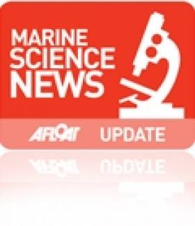
Map of the Aran Sound in Galway Bay
Speakers at this annual seminar of the INFOMAR (INtegrated Mapping FOr the Sustainable development of Ireland's MARine Resource) programme will discuss the discovery of new and historic underwater wreck sites, the application of seabed mapping in the selection of sites for generating wave energy, the protection of fish spawning grounds, and the planning of fish farm sites.
The INFOMAR programme is a jointly managed programme between the Marine Institute and the Geological Survey of Ireland (GSI) and is funded by the Department of Communications, Energy and Natural Resources (DCNER).
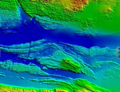
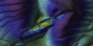
Wreck of the SS. Manchester Merchant
The event will also feature the latest results from a range of EC funded marine mapping initiatives and stunning underwater footage from the recent Irish mission to the volcanic vents of the Mid-Atlantic Ridge over 3,000 metres below the surface of the sea.
Opening the seminar Dr. Peter Heffernan, CEO of the Marine Institute said, "Ireland is leading the way for Europe in marine mapping and in laying the foundations for the sustainable management of our ocean space. Surveying the gateways to our ports, mapping our fish spawning grounds, finding routes for marine telecommunications cables and selecting the best sites for ocean energy generation all rely on accurate seabed mapping capability, which Ireland now possesses."
In addition to its large scale marine mapping remit, INFOMAR's Value Added Programme is co-ordinating an integrated multidisciplinary approach to the handling, processing and application of its ever-expanding marine data set.
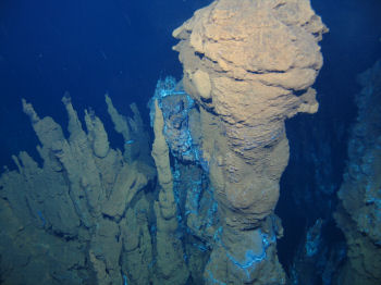
Deepwater photograph from the mid-Atlantic Ridge
As a result of its latest call for research proposals, INFOMAR received 32 submissions for studies on such subjects as the appraisal of seabed data for tidal energy generation, the integration of satellite and marine data for coastal mapping and the use of new graphic animation techniques to integrate environmental information into seabed mapping displays.
"INFOMAR is a key mechanism to unlock the economic potential of our ocean territory," said Koen Verbruggen of the GSI. "By linking industry and academia to the realisation of our government's objectives and requirements around sustainable ocean development we will strengthen Ireland's position on this new frontier and expand our capability to deliver services and solutions to all marine sectors – in Ireland, in Europe and across the world."
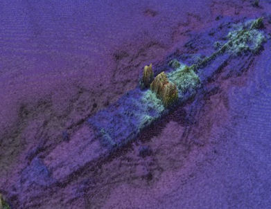
Wreck of the sunken Guinness ship W.M. Barkley off Dublin Bay
As well as looking to the future, Ireland's maritime past will be explored in a presentation by the Underwater Archaeology Unit of the Department of Arts, Heritage and the Gaeltacht on the discovery of a probably late 16th century wreck off Rutland Island, Co. Donegal. The wreck, which may have been an armed merchant ship, a pirate or naval vessel potentially associated with the local Gaelic lordships or the Spanish Armada of 1588, is an extremely important find that could add greatly to our understanding of Ireland's maritime heritage.
'The Sea: One of Ireland's Greatest Natural Resources' - Coveney

The Minister was speaking during a visit to the Marine Institute's research vessel, RV Celtic Explorer, on its return from a mission to the Labrador and Newfoundland Seas.
He added "I am particularly pleased that this is my first official engagement as Minister for Agriculture, Marine and Food. The work of the RV Celtic Explorer highlights the essential nature of marine research, development and sustainable management, through which Ireland is developing a strong and well-deserved reputation as an emerging centre of excellence, where we have prominent roles in many European and international marine science bodies."
Minister Coveney commended the Marine Institute and its Chief Executive, Dr Peter Heffernan, for its leading and proactive role in the areas of fisheries science, marine environment and food safety as well as ocean science and said that he looked forward to working closely with the Institute and benefitting from the research and advice which they would undertake and provide.
The Minister noted that Ireland's two national research vessels – RV Celtic Explorer and RV Celtic Voyager – will record 267 days at sea during 2011, during which they will be engaged in fisheries surveys, underwater mapping, climate studies and deepwater surveys.

Seeing the capabilities of Ireland's largest research vessel and the work of the Marine Institute, Mr Simon Coveney highlighted the importance the Marine Sector has on the Irish economy. "The seas and ocean that surround the land of Ireland is arguably one of our countries greatest natural resources. Through marine research, development and sustainable management, Ireland is developing a strong reputation as an emerging centre of excellence, where we have prominent roles in many European and international marine science bodies," he said.
Ireland's national research vessels RV Celtic Explorer and RV Celtic Voyager will record 627 days at sea between the two during 2011. Their work will range from fisheries surveys to underwater mapping and from climate studies to deepwater surveys with the remotely operated submersible ROV Holland 1.
"The work conducted on the vessels continues to feed into the success in attracting EU funding to Ireland's marine science programmes that have been achieved by our strategic approach to marine science planning" explained Dr Peter Heffernan, CEO of the Marine Institute.
"The award of funding projects shows that partnerships between academics and small businesses can yield significant dividends in creating jobs, generating economic revenue and the supply of raw materials for new industries ranging from ocean energy and environmental monitoring technologies to marine-inspired pharmaceuticals and food ingredients" he further said.


 passes Copper Point Light at Long Island in the first 2024 summer sailing season at Schull Harbour Sailing Club")


 will be going head-to-head with long-lost multi-club-representing sister Two Farr at Howth’s three-day Wave Regatta, starting Friday")


 with his best mate, getting into battle mood in the North African desert during World War II of 1939-45. Anyone who gets along well with a Jack Russell terrier, while looking so very like superstar actor Liam Neeson before Neeson was born, must have had some redeeming features - even if he was a danger to all when partying in a new kitchen")

