Menu

Ireland's sailing, boating & maritime magazine

Displaying items by tag: Sea Level

East Cork, Waterford, Galway and the Shannon Estuary will be the first to bear the brunt of an “alarming and startling” rise in sea levels, a TD has warned.

As the Irish Examiner reports, David Stanton (Cork East) expressed his fears of a “truly frightening” outcome for many coastal communities in the continued absence of a national coastal risk strategy.

“There is no point waiting until the seawater is up to our knees and then saying we should have planned for this 20 years ago,” he said.

The Irish Examiner has more on the story HERE.

Published in Coastal Notes
Tagged under

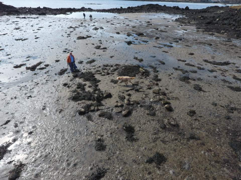
Discovery of the remains of a “drowned” prehistoric house in north Connemara may be further evidence of sea-level rise along the Atlantic coast in the last millennium.

As The Sunday Times reports today, parts of a small prehistoric dwelling covered by sea except at low spring tide have been identified by archaeologist Michael Gibbons and engineer Shane Joyce on the coast south-west of Clifden, Co Galway.

The site is in a sheltered “lagoon-like setting” on the tip of the Faul peninsula, at the junction of Clifden and Ardbear bays.

Gibbons said that the structure is similar in size to early Neolithic houses, and it is protected from tidal surges by Oileán Gearr or Islandagar, a small island on its western side.

Gibbons said it was further evidence of a “drowned prehistoric landscape”, which has been researched and dated by NUI Galway palaeoecologists Prof Michael O’Connell and Dr Karen Molloy.

O’Connell and Molloy have estimated that sea levels rose by as much as four metres on the Atlantic coast in later prehistory - as in 1,000 years ago – with Galway Bay being younger than originally estimated.

Prof O’Connell said that it was “quite reasonable” to suggest the structure identified by Gibbons and Joyce may be early Neolithic, given that sea level rise occurred in the late Neolithic period.

O’Connell and Molloy’s work focused on tree stumps, believed to be bog pine, which have been exposed at low tide by storms dating back to 2010, along with pollen analysis of coastal peat deposits.

Gibbons said that a shell midden dating from 4,000 BC on the Errislannan peninsula, just south-west of the Faul location, was also evidence of Neolithic settlement by early farmers.

Read The Sunday Times report here

Published in Coastal Notes
Tagged under

Dublin Bay’s sea level seems to be rising faster than forecast — and at twice the global average over the past two decades.

The Irish Times reports on this startling claim from Dun Laoghaire-Rathdown County Council’s (DLRCoCo) climate change action plan, which also notes that weather extremes are “likely to increase in their frequency and intensity”.

The report comes following one of Ireland’s hottest summers on record, itself just months after a first ever Status Red warning for snow was issued by Met Éireann.

Three Dublin local authorities launched their climate action plans on Monday (9 September), with DLRCoCo’s plan pledging to “prioritise nature-based flood defences where possible” over the next five years.

The Irish Times has much more on the story HERE.

Published in Dublin Bay

Marine Institute Research Vessel Tom Crean

Ireland’s new marine research vessel will be named the RV Tom Crean after the renowned County Kerry seaman and explorer who undertook three major groundbreaking expeditions to the Antarctic in the early years of the 20th Century which sought to increase scientific knowledge and to explore unreached areas of the world, at that time.

Ireland's new multi-purpose marine research vessel RV Tom Crean, was delivered in July 2022 and will be used by the Marine Institute and other State agencies and universities to undertake fisheries research, oceanographic and environmental research, seabed mapping surveys; as well as maintaining and deploying weather buoys, observational infrastructure and Remotely Operated Vehicles.

The RV Tom Crean will also enable the Marine Institute to continue to lead and support high-quality scientific surveys that contribute to Ireland's position as a leader in marine science. The research vessel is a modern, multipurpose, silent vessel (designed to meet the stringent criteria of the ICES 209 noise standard for fisheries research), capable of operating in the Irish Exclusive Economic Zone (EEZ). The Tom Crean is able to go to sea for at least 21 days at a time and is designed to operate in harsh sea conditions.

RV Tom Crean Specification Overview

  • Length Overall: 52.8 m
  • Beam 14m
  • Draft 5.2M 

Power

  • Main Propulsion Motor 2000 kw
  • Bow Thruster 780 kw
  • Tunnel thruster 400 kw

Other

  • Endurance  21 Days
  • Range of 8,000 nautical miles
  • DP1 Dynamic Positioning
  • Capacity for 3 x 20ft Containers

Irish Marine Research activities

The new state-of-the-art multi-purpose marine research vessel will carry out a wide range of marine research activities, including vital fisheries, climate change-related research, seabed mapping and oceanography.

The new 52.8-metre modern research vessel, which will replace the 31-metre RV Celtic Voyager, has been commissioned with funding provided by the Department of Agriculture, Food and the Marine approved by the Government of Ireland.

According to Aodhán FitzGerald, Research Vessel Manager of the MI, the RV Tom Crean will feature an articulated boom crane aft (6t@ 10m, 3T@ 15m), located on the aft-gantry. This will be largely used for loading science equipment and net and equipment handling offshore.

Mounted at the stern is a 10T A-frame aft which can articulate through 170 degrees which are for deploying and recovering large science equipment such as a remotely operated vehicle (ROV’s), towed sleds and for fishing operations.

In addition the fitting of an 8 Ton starboard side T Frame for deploying grabs and corers to 4000m which is the same depth applicable to when the vessel is heaving but is compensated by a CTD system consisting of a winch and frame during such operations.

The vessel will have the regulation MOB boat on a dedicated davit and the facility to carry a 6.5m Rigid Inflatable tender on the port side.

Also at the aft deck is where the 'Holland 1' Work class ROV and the University of Limericks 'Etain' sub-Atlantic ROV will be positioned. In addition up to 3 x 20’ (TEU) containers can be carried.

The newbuild has been engineered to endure increasing harsher conditions and the punishing weather systems encountered in the North-East Atlantic where deployments of RV Tom Crean on surveys spent up to 21 days duration.

In addition, RV Tom Crean will be able to operate in an ultra silent-mode, which is crucial to meet the stringent criteria of the ICES 209 noise standard for fisheries research purposes.

The classification of the newbuild as been appointed to Lloyds and below is a list of the main capabilities and duties to be tasked by RV Tom Crean:

  • Oceanographic surveys, incl. CTD water sampling
  • Fishery research operations
  • Acoustic research operations
  • Environmental research and sampling operation incl. coring
  • ROV and AUV/ASV Surveys
  • Buoy/Mooring operations