


Displaying items by tag: Subsea Cable
Galway-Iceland Subsea Cable Part of a "New Industrial Revolution"- Ryan
Ireland is pursuing a “gateway to Europe” strategy for subsea telecoms cables, Minister for Communications Eamon Ryan pledged as he marked installation of one such link on the west coast.
Speaking at the landing ceremony for “IRIS”, a subsea telecoms cable between Galway and Iceland, Mr Ryan described it as “part of the new industrial revolution – one that combines high quality, digital infrastructure with renewable technology, infrastructure and skills”.
As Afloat reported in September 2020, The new cable, landing in Galway, will provide direct high-capacity links to Iceland with onward connectivity to Northern Europe via Denmark, he said. The cable system will greatly increase capacity and diversity of internet connections to Ireland, he said.
Ireland is “poised to become a key international connectivity hub between North America and Europe”, he and his junior communications minister Ossian Smyth said.
"it is the first subsea cable connected to Ireland that is not linked to Britain or North America"
“The IRIS cable enhances Ireland’s digital connectivity internationally, providing the essential factors needed by businesses to be able to compete globally and attract investment. This direct, high-capacity route to Iceland and through to Northern Europe provides opportunities for all businesses to extend their market reach,” Ryan said.
Mr Smyth described it as a “landmark in the history of Irish communications”, as it is the first subsea cable connected to Ireland that is not linked to Britain or North America.
He noted that Ireland has been an intercontinental communications hub since 1858, when the first transatlantic cable linking London and New York was routed through Ireland.
“This is the start of a strategic move by Ireland to connect directly to Northern and Southern Europe,” Smyth said, declaring that Ireland is “now open for business to further subsea cables”.
The landing station diversity in Ireland is “particularly advantageous”, the ministers noted, because the cable routes come from multiple directions, minimising the risk of simultaneous failure.
The IRIS cable is owned and operated by Farice. a company fully owned by the Icelandic Government, which contracted SubCom, a global subsea fibre optic cable system supply company, to install the cable system.
Post-Lay Inspection and Burial of Havhingsten Fibre Optic Cable in Irish Sea From This Weekend
Further to previous installation works on the Havhingsten fibre optic telecommunication cable system in the Irish Sea, post-lay inspection and burial (PLIB) of the cable is planned to begin later this week.
Works outside Irish and Isle of Man territorial waters are will start on Friday 14 January and continue until next Thursday 20 January, subject to weather.
It is advised that extra care is taken when vessels are operating near this area and that no vessel should trawl within 500m.
Installation will be via industry-standard burial tools including water jetting with remote operated vehicle (ROV). The target cable burial depth is 1.5m below seabed level in the region.
There will be two locations where PLIB will be performed: at Final Splice (FS) location outside Irish territorial waters, and at Branching Unit (BU) location outside of Isle of Man territorial waters.
The operations will be conducted by the cable installation vessel CS Ile d’Aix (callsign FICI) which will be working on a 24-hour basis, and will display appropriate day shapes and lights during reduced visibility and night operations.
All vessels operating within this area are requested to keep their distance and pass at minimum speed to reduce vessel wash.
For more information, including coordinates and contact details, see Marine Notice No 01 of 2022 attached below.
Rock Placements Ahead of Fibre Optic Cable Works in Irish Sea
Further to last week’s Marine Notice advising of the latest works on the Havhingsten fibre optic telecommunication cable system this month, rock placement activities in the Irish Sea are also planned from this weekend.
There are four crossing locations in the Irish Sea where rock placement will be installed from this Saturday 11 December, but only one will be within the Irish EEZ, at the offshore extent.
Rock placement will be via industry standard, and activity at each site will last for up to 15 hours.
The operations will be conducted by the cable installation vessel Stornes (callsign PCKX), which will operate on a 24-hour basis and display appropriate day shapes and lights during reduced visibility and night operations.
All vessels operating within this area are requested to keep their distance and pass at minimum speed to reduce vessel wash.
Further details, including relevant coordinates and contact information, can be found in Marine Notice No 65 of 2021 which is available to download below.
Fibre Optic Cable Installation Works Continue in Irish Sea This Month
Installation of the Havhingsten fibre optic telecommunication cable system in the Irish Sea inside of the Irish 12-nautical-mile zone is planned for this month.
It follows works this past autumn in the Irish Sea outside of territorial waters, as previously reported on Afloat.ie.
Works are planned to start on Monday 13 December, subject to weather and full execution of the foreshore licence.
The latest operations on the cable route for the western Irish Sea region, which lands at Loughshinny, will be conducted by the cable installation vessel CS Île de Batz (callsign FOSU).
It will be working on a 24-hour basis and will display appropriate day shapes and lights during reduced visibility and night operations.
All other vessels operating within its work area are requested to keep their distance and pass at minimum speed to reduce vessel wash.
Details of the coordinates of the work area and contact information can be found in Marine Notice No 64 of 2021, which can be downloaded below.
Installation of the Havhingsten fibre optic telecommunication cable system is planned from Monday 23 August until Thursday 23 September in the Irish Sea outside of the Irish 12-nautical-mile zone.
Works within 12 nautical miles of Ireland’s mainland are planned from December 2021 subject to weather and operational conditions.
There will also be associated rock placement operations post-cable installation at four locations within the western Irish Sea and these works are expected in between October and December, weather permitting.
The entire cable system will comprise marine elements that pass from Denmark to the UK (NE region), and from the UK (NW) to Ireland, with two segments installed into landfalls on the Isle of Man. The cable route for the western Irish Sea region lands at Loughshinny in north Co Dublin.
Installation will be via industry standard burial tools including water jetting and ploughing. Target cable burial depth is 1.5m below seabed level in the region.
It is anticipated that installation operations in UK/Irish waters will occupy up to a maximum 500m width (250m either side of cable). The cable itself will occupy only 40mm of the seabed. Expected speed of installation will be approximately 17km per day.
Works will be conducted by the cable installation vessel CS Recorder (callsign MATL3) which will operate 24 hours a day and will display appropriate day shapes and lights during reduced visibility and night operations.
All vessels operating within its vicinity are requested to keep their distance, and pass at minimum speed to reduce vessel wash.
Full details, including coordinates for the work areas and rock armour placements, are included in Marine Notice No 45 of 2021 which can be downloaded below.
Subsea Cable Survey Operations Off South-East Coast
Mariners off the South-East Coast of Ireland are advised of subsea cable survey operations currently under way, subject to weather conditions.
The survey was scheduled to begin this past Thursday 26 November and continue for at least eight days and up to two weeks.
It follows a route south-west from the 2m contour at Ballyteige Bay before veering south to the 12-nautical-mile limit.
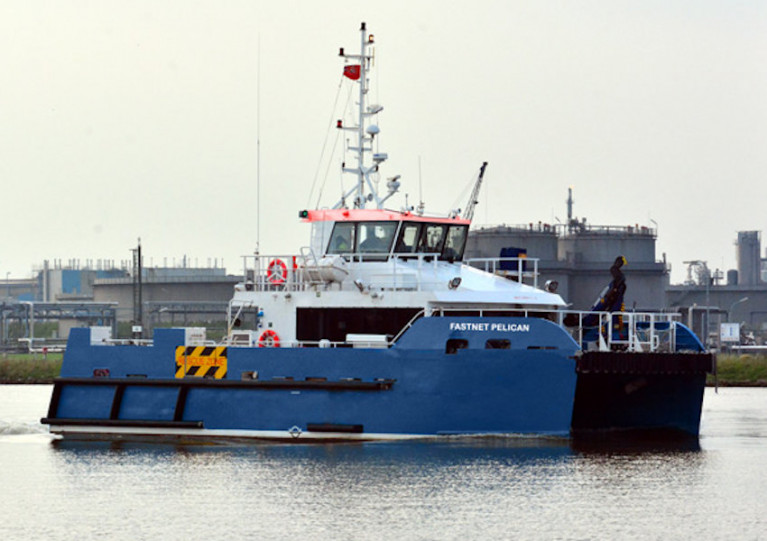
The DNV-classed wind farm service and survey support vessel Fastnet Pelican (Callsign 2FNX7) is conducting this survey using a multibeam echo sounder and sub bottom profiler as well as a towed array with a sidescan sonar and magnetometer.
The vessel will have active AIS and will display all relevant lights and shapes.
Due to restricted manoeuvrability, other vessels are asked to maintain a distance of at least one nautical mile from the Fastnet Pelican.
Full details of this survey, including all relevant coordinates, are included in Marine Notice No 54 of 2020, a PDF of which can be downloaded below.
Planned works on the Portrane Pre-Lay Shore End installation for the Rockabill Subsea Cable are being carried out from the coast of Portrane, Co Dublin.
Scheduled to start yesterday. Monday 1 July, they will continue to next Wednesday 10 July. During this first Pre-lay Shore End phase of the project, the cable will be installed and buried in the Irish Sea by the utility vessel Roxane Z (Callsign FIRJ).
The vessel will monitor VHF Channel 16 at all times. All vessels, particularly those engaged in fishing, are requested to give the Roxane Z a wide berth and keep a sharp lookout in the relevant areas.
Details and co-ordinates of the work area are included in Marine Notice No 20 of 2019, a PDF of which is available to read or download HERE.
Another recent Marine Notice includes an updated schedule of examinations for the Certificate of Competency for Deck Officers, Marine Engineer Officers, Skippers and Second Hands, commencing Monday 2 September this year.


: helm Nathan Burke, station mechanic and coxswain Kieran ‘Colley’ O’Connell and helm Gary Hayes")
 is the popular overall winner of the Lambay Lady, top trophy in Howth YC’s Wave Regatta")


 won the Round Ireland Race from Wicklow every which way as Tonnere de Breskens for the late great Piet Vroon in 2010, and with her return for 2024’s race as Searcher, she is immediately among the favourites")
