Menu

Ireland's sailing, boating & maritime magazine

Displaying items by tag: Institute

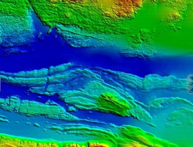
New developments in Ireland's capacity to uncover its past and explore its future economic potential will be revealed today and tomorrow (16th and 17th November) at a seminar on underwater mapping at the Marine Institute in Galway.

INFOMARNov2011AranSoundGalwayBay

Map of the Aran Sound in Galway Bay

Speakers at this annual seminar of the INFOMAR (INtegrated Mapping FOr the Sustainable development of Ireland's MARine Resource) programme will discuss the discovery of new and historic underwater wreck sites, the application of seabed mapping in the selection of sites for generating wave energy, the protection of fish spawning grounds, and the planning of fish farm sites.

The INFOMAR programme is a jointly managed programme between the Marine Institute and the Geological Survey of Ireland (GSI) and is funded by the Department of Communications, Energy and Natural Resources (DCNER).
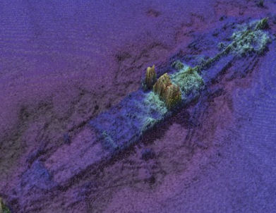
INFOMARNov2011ManchesterMerchant

Wreck of the SS. Manchester Merchant

The event will also feature the latest results from a range of EC funded marine mapping initiatives and stunning underwater footage from the recent Irish mission to the volcanic vents of the Mid-Atlantic Ridge over 3,000 metres below the surface of the sea.

Opening the seminar Dr. Peter Heffernan, CEO of the Marine Institute said, "Ireland is leading the way for Europe in marine mapping and in laying the foundations for the sustainable management of our ocean space. Surveying the gateways to our ports, mapping our fish spawning grounds, finding routes for marine telecommunications cables and selecting the best sites for ocean energy generation all rely on accurate seabed mapping capability, which Ireland now possesses."

In addition to its large scale marine mapping remit, INFOMAR's Value Added Programme is co-ordinating an integrated multidisciplinary approach to the handling, processing and application of its ever-expanding marine data set.
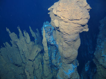
Ventpic2large

Deepwater photograph from the mid-Atlantic Ridge

As a result of its latest call for research proposals, INFOMAR received 32 submissions for studies on such subjects as the appraisal of seabed data for tidal energy generation, the integration of satellite and marine data for coastal mapping and the use of new graphic animation techniques to integrate environmental information into seabed mapping displays.

"INFOMAR is a key mechanism to unlock the economic potential of our ocean territory," said Koen Verbruggen of the GSI. "By linking industry and academia to the realisation of our government's objectives and requirements around sustainable ocean development we will strengthen Ireland's position on this new frontier and expand our capability to deliver services and solutions to all marine sectors – in Ireland, in Europe and across the world."
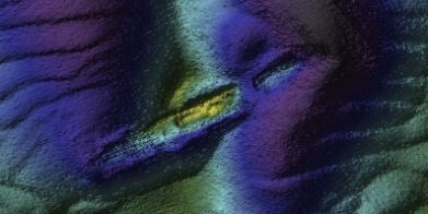
INFOMARNov2011WMBarkley

Wreck of the sunken Guinness ship W.M. Barkley off Dublin Bay

As well as looking to the future, Ireland's maritime past will be explored in a presentation by the Underwater Archaeology Unit of the Department of Arts, Heritage and the Gaeltacht on the discovery of a probably late 16th century wreck off Rutland Island, Co. Donegal. The wreck, which may have been an armed merchant ship, a pirate or naval vessel potentially associated with the local Gaelic lordships or the Spanish Armada of 1588, is an extremely important find that could add greatly to our understanding of Ireland's maritime heritage.

Published in Marine Science
Tagged under
In his first week in office Marine Minister Simon Coveney has moved to highlight the significance of the marine sector to Ireland. The statement came in his first official engagement at the new Department of Agriculture, Marine and Food. Minister Coveney said: "the seas and ocean that surround the island of Ireland are among this country's greatest natural resources."

The Minister was speaking during a visit to the Marine Institute's research vessel, RV Celtic Explorer, on its return from a mission to the Labrador and Newfoundland Seas.

He added "I am particularly pleased that this is my first official engagement as Minister for Agriculture, Marine and Food. The work of the RV Celtic Explorer highlights the essential nature of marine research, development and sustainable management, through which Ireland is developing a strong and well-deserved reputation as an emerging centre of excellence, where we have prominent roles in many European and international marine science bodies."

Minister Coveney commended the Marine Institute and its Chief Executive, Dr Peter Heffernan, for its leading and proactive role in the areas of fisheries science, marine environment and food safety as well as ocean science and said that he looked forward to working closely with the Institute and benefitting from the research and advice which they would undertake and provide.

The Minister noted that Ireland's two national research vessels – RV Celtic Explorer and RV Celtic Voyager – will record 267 days at sea during 2011, during which they will be engaged in fisheries surveys, underwater mapping, climate studies and deepwater surveys.

Published in Marine Science
The Marine Institute has issued a statement congratulating Mr Simon Coveney TD on his new appointment as the Minister for Agriculture, Marine and Food today (11th March 2011), during his visit on board the RV Celtic Explorer in Cork, after its return from the mission to the Labrador and Newfoundland Seas.

Seeing the capabilities of Ireland's largest research vessel and the work of the Marine Institute, Mr Simon Coveney highlighted the importance the Marine Sector has on the Irish economy. "The seas and ocean that surround the land of Ireland is arguably one of our countries greatest natural resources. Through marine research, development and sustainable management, Ireland is developing a strong reputation as an emerging centre of excellence, where we have prominent roles in many European and international marine science bodies," he said.

Ireland's national research vessels RV Celtic Explorer and RV Celtic Voyager will record 627 days at sea between the two during 2011. Their work will range from fisheries surveys to underwater mapping and from climate studies to deepwater surveys with the remotely operated submersible ROV Holland 1.

"The work conducted on the vessels continues to feed into the success in attracting EU funding to Ireland's marine science programmes that have been achieved by our strategic approach to marine science planning" explained Dr Peter Heffernan, CEO of the Marine Institute.

"The award of funding projects shows that partnerships between academics and small businesses can yield significant dividends in creating jobs, generating economic revenue and the supply of raw materials for new industries ranging from ocean energy and environmental monitoring technologies to marine-inspired pharmaceuticals and food ingredients" he further said.

Published in Marine Science

Marine Protected Areas (MPAs) - FAQS

Marine protected areas (MPAs) are geographically defined maritime areas where human activities are managed to protect important natural or cultural resources. In addition to conserving marine species and habitats, MPAs can support maritime economic activity and reduce the effects of climate change and ocean acidification.

MPAs can be found across a range of marine habitats, from the open ocean to coastal areas, intertidal zones, bays and estuaries. Marine protected areas are defined areas where human activities are managed to protect important natural or cultural resources.

The world's first MPA is said to have been the Fort Jefferson National Monument in Florida, North America, which covered 18,850 hectares of sea and 35 hectares of coastal land. This location was designated in 1935, but the main drive for MPAs came much later. The current global movement can be traced to the first World Congress on National Parks in 1962, and initiation in 1976 of a process to deliver exclusive rights to sovereign states over waters up to 200 nautical miles out then began to provide new focus

The Rio ‘Earth Summit’ on climate change in 1992 saw a global MPA area target of 10% by the 2010 deadline. When this was not met, an “Aichi target 11” was set requiring 10% coverage by 2020. There has been repeated efforts since then to tighten up MPA requirements.

Marae Moana is a multiple-use marine protected area created on July 13th 2017 by the government of the Cook islands in the south Pacific, north- east of New Zealand. The area extends across over 1.9 million square kilometres. However, In September 2019, Jacqueline Evans, a prominent marine biologist and Goldman environmental award winner who was openly critical of the government's plans for seabed mining, was replaced as director of the park by the Cook Islands prime minister’s office. The move attracted local media criticism, as Evans was responsible for developing the Marae Moana policy and the Marae Moana Act, She had worked on raising funding for the park, expanding policy and regulations and developing a plan that designates permitted areas for industrial activities.

Criteria for identifying and selecting MPAs depends on the overall objective or direction of the programme identified by the coastal state. For example, if the objective is to safeguard ecological habitats, the criteria will emphasise habitat diversity and the unique nature of the particular area.

Permanence of MPAs can vary internationally. Some are established under legislative action or under a different regulatory mechanism to exist permanently into the future. Others are intended to last only a few months or years.

Yes, Ireland has MPA cover in about 2.13 per cent of our waters. Although much of Ireland’s marine environment is regarded as in “generally good condition”, according to an expert group report for Government published in January 2021, it says that biodiversity loss and ecosystem degradation are of “wide concern due to increasing pressures such as overexploitation, habitat loss, pollution, and climate change”.

The Government has set a target of 30 per cent MPA coverage by 2030, and moves are already being made in that direction. However, environmentalists are dubious, pointing out that a previous target of ten per cent by 2020 was not met.

Conservation and sustainable management of the marine environment has been mandated by a number of international agreements and legal obligations, as an expert group report to government has pointed out. There are specific requirements for area-based protection in the EU Marine Strategy Framework Directive (MSFD), the OSPAR Convention, the UN Convention on Biological Diversity and the UN Sustainable Development Goals. 

Yes, the Marine Strategy Framework directive (2008/56/EC) required member states to put measures in place to achieve or maintain good environmental status in their waters by 2020. Under the directive a coherent and representative network of MPAs had to be created by 2016.

Ireland was about halfway up the EU table in designating protected areas under existing habitats and bird directives in a comparison published by the European Commission in 2009. However, the Fair Seas campaign, an environmental coalition formed in 2022, points out that Ireland is “lagging behind “ even our closest neighbours, such as Scotland which has 37 per cent. The Fair Seas campaign wants at least 10 per cent of Irish waters to be designated as “fully protected” by 2025, and “at least” 30 per cent by 2030.

Nearly a quarter of Britain’s territorial waters are covered by MPAs, set up to protect vital ecosystems and species. However, a conservation NGO, Oceana, said that analysis of fishing vessel tracking data published in The Guardian in October 2020 found that more than 97% of British MPAs created to safeguard ocean habitats, are being dredged and bottom trawled. 

There’s the rub. Currently, there is no definition of an MPA in Irish law, and environment protections under the Wildlife Acts only apply to the foreshore.

Current protection in marine areas beyond 12 nautical miles is limited to measures taken under the EU Birds and Habitats Directives or the OSPAR Convention. This means that habitats and species that are not listed in the EU Directives, but which may be locally, nationally or internationally important, cannot currently be afforded the necessary protection

Yes. In late March 2022, Minister for Housing Darragh O’Brien said that the Government had begun developing “stand-alone legislation” to enable identification, designation and management of MPAs to meet Ireland’s national and international commitments.

Yes. Environmental groups are not happy, as they have pointed out that legislation on marine planning took precedence over legislation on MPAs, due to the push to develop offshore renewable energy.

No, but some activities may be banned or restricted. Extraction is the main activity affected as in oil and gas activities; mining; dumping; and bottom trawling

The Government’s expert group report noted that MPA designations are likely to have the greatest influence on the “capture fisheries, marine tourism and aquaculture sectors”. It said research suggests that the net impacts on fisheries could ultimately be either positive or negative and will depend on the type of fishery involved and a wide array of other factors.

The same report noted that marine tourism and recreation sector can substantially benefit from MPA designation. However, it said that the “magnitude of the benefits” will depend to a large extent on the location of the MPA sites within the network and the management measures put in place.

© Afloat 2022