


Displaying items by tag: Howth Peninsula
Irish Lights Also Welcomes Duke and Duchess of Cambridge to Howth at the Baily Lighthouse
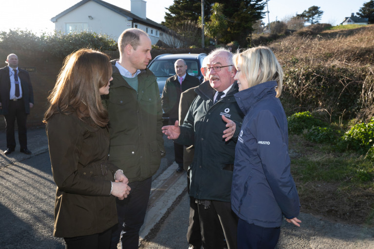
The Commissioners of Irish Lights were also delighted to welcome The Duke and Duchess of Cambridge yesterday to the Baily Lighthouse, Howth Peninsula (see story: Marine Institute) as part of the UK Royal couple's first official visit to Ireland which concludes today.
According to CIL, the Duke and Duchess of Cambridge met with Kieran Crowley, Chairman and Yvonne Shields O’Connor, CEO, Irish Lights at the Baily Lighthouse (marking the northern approaches to Dublin Bay). They discussed the long-standing historic relationship between Irish Lights and their General Lighthouse Authority (GLA) partners in the United Kingdom, Trinity House and Northern Lighthouse Board.
This active partnership sees the three authorities co-operating on a daily basis to deliver a range of services to ensure safe navigation around the Irish and UK coasts, meeting the Irish and UK governments’ obligations under the Safety of Life at Sea Convention.
Yvonne Shields O’Connor, CEO, Irish Lights said: "It is an honour to welcome Their Royal Highnesses The Duke and Duchess of Cambridge and to acknowledge the close working partnership that exists between Irish Lights and our colleagues in Trinity House and the Northern Lighthouse Board. For over 150 years we have worked in close collaboration to ensure safety at sea for mariners through our network of lighthouses, buoys and electronic aids to navigation. We recognise the hugely valuable work Their Royal Highnesses are doing in relation to climate change and marine conservation, which is very relevant to the service that we provide.”
Afloat adds the visit follows less than a year ago when Princess Anne in April 2019 also visited the Baily Lighthouse in addition to CIL's headquarters in Dun Laoghaire Harbour and boarded the ILV Granuaile (named after the 16th century Irish Pirate Queen from Mayo). Grace O'Malley who was regarded as a rebel, pirate and had 'disloyal' activities sailed to London to meet Queen Elizabeth I at Greenwich Palace in 1593.
Role on to the present day as Princess Anne, The Princess Royal is Master of The Corporation of Trinity House, a position held since May 2011. It was in that same month and year when Queen Elizabeth II made a historic first visit to Ireland.
Trinity House as one of the trio of GLA partners is responsble for the waters off England, Wales, the Channel Islands and Gibraltar, while Northern Lighthouse Board has the seas off Scotland and the Isle of Man. As for the remaining partner, Irish Lights whose mission is the safe navigation at sea and as a maritime organisation delivering essential 24/7 safety and navigation services around the coast to include N. Ireland.
Minehunter that Served in Libya Anchors in Dublin Bay
#NAVAL ANCHORAGE – A Royal Navy mine-hunter HMS Bangor (MI09) which took part in Libyan operations last year, anchored overnight in Dublin Bay during the north-easterly gale force winds, writes Jehan Ashmore.
Unlike the majority of vessels which anchor in the south of the bay, she unusually took anchorage north of the main shipping lane for Dublin Port by positioning off Sutton South on Howth Peninsula.
HMS Bangor is a Sandown class mine-hunter and she is due to continue her northbound passage through the Irish Sea to spend Easter at her affiliated namesake town on the shores of Belfast Lough.
Her last call to Bangor was to celebrate Armed Forces Day 2010 and also in that year she called to Dublin, click HERE for that report.
On this occasion she will tell of her role supporting NATO operations off the coast of Libya. During Operation Unified Protector, the mine-hunter's task involved 120 days of non-stop action by scouring miles of sea bed off Libya as the battle between rebels and Colonel Gaddafi raged.
Built in 1999 by Vosper Thorneycroft, Southampton, the glass-reinforced plastic (GRP) ship and her 34 crew undertook the painstaking work. This paid off when the 55m vessel found a 2,400-pound (1000kg) mine and a torpedo lying on the seabed off the port of Tobruk in eastern Libya.
Both were safely destroyed using the ship's Sea Fox system – an underwater drone armed with explosive charges.
HMS Bangor is among seven of her class based at on the Clyde, Scotland. They each displace 600 tonnes and have a range of 2,500 nautical miles. For further details about the class, click HERE.
Tanker and Lifeboats Conduct Emergency Exercises off Dalkey Island
Crew kitted in similarly bright orange coloured sea safety-survival suits entered the lifeboat before it plunged into the water. The activity was observed through the binocular-scope which overlooks Coliemore Harbour with excellent views across the sound to Dalkey Island, Dublin Bay and Howth Peninsula.
The binocular-scope does not require payment to operate and was unveiled in 2008 in memory of local resident the late Dr. John de Courcy Ireland, the 'father' of maritime Ireland (to read more click HERE). He was for 26 years a honorary secretary of the local RNLI station in Dun Laoghaire and a staunch campaigner of Irish maritime affairs.
Each Monday a routine lifeboat practice is conducted by the 47ft Trent class ALB (all-weather lifeboat) RNLB Anna Livia (info and PHOTO). Last night's drill also involved the new D-class ILB (inshore lifeboat) RNLB Réalt na Mara which was named earlier this year by Kathy Kenny, wife of RTE presenter Pat Kenny.
Under the cover of darkness the crew of the ILB Realt na Mara simulated an 'injured casualty' on the island where the casualty was prepared to be taken off by stretcher from the island's small harbour. From there the casualty was transferred to the larger RNLB Anna Livia which lay offshore. During the exercise, powerful searchlight beams from the ALB provided essential light to assist in the transfer operation.
Asides the lifeboats, there is plenty of wildlife to observe on the rocky outcrops at Maiden Rock, Clare Rock and Lamb Island, which forms the second largest island after the main island of 22-acres, where a resident herd of goats have been part of the local community for over 200 years.
As for the South Korean built Cumbrian Fisher, she too has close connections with these waters as she was named in Dublin Port in 2005. She is a frequent caller to Dublin bringing bulk liquid products from the oil refinery in Milford Haven, Pembrokeshire which is a major supplier, serving the demands of the capital.
Dublin Port has two oil jetties which cater for four tankers, where bitumen, chemicals, liquid petroleum gases, molasses and oil are handled on a 41-hectare zone with storage for 330,000 product tonnes to include 6,000 tonnes of LPG. In addition aviation fuel is frequently delivered to the terminal to satisfy the constant demand for aircraft using Dublin Airport.
Cumbrian Fisher alongside her sister Clyde Fisher where built for James Fisher & Sons and in recent years they have tended to take anchorage off Dalkey Island and off the Nose of Howth. In comparison the vast majority of vessels anchor in Dublin Bay which is divided into quadrants for the purposes of anchorage allocation.
Before the completion of the South Wall in Dublin Port, which considerably improved safer access of vessels entering the River Liffey, it was the relative deeper and sheltered waters of Dalkey Sound which were used instead as Dalkey acted as the principle port for Dublin between 14-17th centuries.
Vessels would convey cargoes which were taken to and fro by lighter to the coast where it was carried by horse and cart to nearby Dalkey before onward travel across the exposed plains to Dublin City.
To learn more about Dalkey's medieval maritime heritage with its relationship with the capital of Dublin in addition the use of Dalkey Quarry in the construction of (Kingstown) Dun Laoghaire Harbour, visit the Dalkey Castle & Heritage Centre. To read more go to www.dalkeycastle.com in addition to further information about Dalkey including the local community council newsletters click HERE.
- Dublin Bay
- Dublin Airport
- Dublin Bay News
- Commissioners of Irish Lights
- Irish Lights
- coliemore harbour
- Pembrokeshire
- Dalkey Island
- Port of Dublin
- River Liffey
- Ports and Shipping News
- The Muglins
- Coastal Notes
- Howth Peninsula
- Pat Kenny
- Dalkey Sound
- Lighthouse news
- Irish Lighthouses
- Cumbrian Fisher
- Jas Fisher & Sons
- Clyde Fisher
- Milford Haven Oil Refinery
- Dalkey Castle & Heritage Centre
- Dr. Ireland
- Dr. John de Courcy Ireland
- Irish maritime historian
- Kingstown Harbour
- Kathy Kenny
- RTE presenter Pat Kenny
- South Wall Dublin Port
- Medieval Dalkey
- Dalkey Quarry
- Aviation fuel
- Dalkey Tidy Towns Committee
- Nose of Howth
- Dublin Port Oil Jetty Terminal
- Dalkey Community Council
- Dalkey Island Goats
Dublin Bay Prawn Festival Heads for Howth

A Sampi trail will be held in various pubs and hotels on the Friday night starting at 7pm, no booking is required. On the Saturday afternoon there is a Prawn Shelling Competition starting at 2.30pm.
Howth Yacht Club will open its doors to public viewing on the Saturday and the Howth Coastguard Station (West Pier) will also be open on that day too in addition to the Sunday. The West Pier is also to host a Fishing Techniques demonstration on Sunday at 3pm.
On the mornings of Saturday and Sunday a self-guided walk from Howth to up to Howth Hill taking up to two hours will meet at The Courthouse at 10am. The walk which is to be pre-booked and registered online is also suitable for families. The route is weather dependant and will follow one of the four looped walks.
The Irish Seal Sactuary will be offering a seal watching tour and harbour walks guided by volunteers on the Saturday and Sunday. An information stand will be made available for more details click www.irishsealsanctuary.ie
Throughout the weekend there will be all day events which include island boat / eco tour trips and the National Transport Musuem, noting that these activities will be charged. It should be noted that festival programme is provisional and is subject to change.
For more information about the full festival programme logon HERE and by contacting Howth Tourist Office on 01 8396955 and by email: [email protected]


 with his exuberant crew as they celebrate being overall winners of Howth Wave 2024")


