Menu

Ireland's sailing, boating & maritime magazine

Inland afloat headers


Displaying items by tag: Waterford Estuary

The Irish Port of Waterford has launched a brand new report titled ‘The Maritime Heritage of Waterford Estuary’.

Marine resource economist, Dr Naomi S. Foley, the author of the report, was commissioned by the south-east port to highlight the variety of opportunities to develop and promote the estuary.

To consult the report which is available to view online here, offers an overview of the natural and cultural heritage of Waterford Estuary.

As highlighted in the report are the outlining opportunities for the future sustainable development, promotion and preservation of this heritage that could benefit the coastal communities of the estuary.

The Port of Waterford’s Heritage Committee Chairman, Joe Dreelan said, “This report is an important publication as it helps to place a framework around potential collaborations in order to achieve a number of objectives; including increasing the awareness of the maritime heritage of Waterford Estuary; contributing to a sense of community, pride and place through sustainable social and economic development and work towards strengthening and building on current community development projects.

The chairman added, for example "to those projects funded by the FLAG and LEADER programme in order to promote, preserve and enjoy our unique maritime heritage.”

Welcoming the report, CEO of Waterford Council Michael Walsh said, “Waterford Estuary has a rich maritime heritage and we are delighted to see the breadth of potential opportunities for potential future engagement and development across the areas of natural and cultural heritage".

The CEO also commented "We look forward to collaborating further with Port of Waterford to investigate the possibility of these project proposals. We have seen the success of the Waterford Greenway and note the proposition of a Waterford Estuary Blueway which is certainly something that is on our radar.”

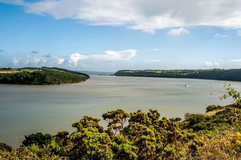
The report gives us a full account of how the villages on both sides of the Wexford and Waterford estuary became such vital cogs in the trading success of Waterford City and the wider Southeast, and laterally how fishing became central to the villages’ economic wellbeing.

In commissioning and championing this report, Port of Waterford wishes to acknowledge the role Cheekpoint, Passage East, Duncannon, Dunmore East, Ballyhack and Arthurstown played in the Port’s development over the generations.

Published in Irish Ports

Inshore fishermen are calling on the Environmental Protection Agency (EPA) to investigate why stocks of shellfish have declined and seaweed has stopped growing in parts of the Waterford estuary.

As The Times Ireland edition reports today, the National Inshore Fishermen’s Association (NIFA) is also appealing to the EPA to refuse a revised discharge license application sought by a gas-powered plant at Great Island, near Campile, Co Wexford, on the confluence of the Suir and Barrow river estuaries.

NIFA, which was established in 2017 to represent some 200 commercial inshore boats of less than 12 metres in length, works closely with the National Inshore Fishermen’s Organisation (NIFO), which also opposes the license application.

NIFA general secretary Alex Crowley says that the Waterford estuary supports important inshore fisheries for shrimp, whelk, lobster, velvet and green crab, and there is also pelagic trawling for sprat and herring and dredging for various bivalve species.

The estuary is close to an “important spawning ground for a number of commercially important species including Celtic Sea herring”, the organisations state.

Crowley says that local fishermen have noticed how shrimp, whelk and velvet crab stocks have recorded a “noticeable decline”.

The fishermen claim that there has been “significant die off” of bivalve shellfish species, and seaweed no longer grows in the intertidal zone for “some miles” downstream of the plant’s current outfall pipe.

SSE Generation’s 464MW natural gas-fired combined cycle gas turbine (CCGT) power plant dates from 2015, replacing the former oil-fired station run by the ESB.

All large combustion plants are now required to renew their emissions licence under the EU’s Industrial Emissions Directive, and SSE’s application for a licence review is part of this process, the company says.

The company describes the plant as “one of the cleanest and most-efficient power stations on the island of Ireland, generating enough electricity to power half a million Irish homes”.

It says it works with the EPA on an ongoing basis to ensure it is compliant with its licence conditions at all times.

However, NIFA is concerned that the EPA learned last September that some 1300 tonnes of chemicals were being discharged into the estuary under a license covering just five tonnes.

NIFA is specifically concerned with the use of chlorine, in the form of sodium hypochlorite, which is added to cooling water at intake to prevent fouling of pipes within the power station.

The EPA said it had investigated the allegations and found SSE to be “compliant with the license limits on the concentration of chlorine in discharged water”.

The EPA said it found no evidence that SEE’s discharge was having “such an effect on shellfish and fish mortality”, and said there was “insufficient evidence to conclude which individual pressures, if any, are contributing to impacts on marine life in the estuary”.

The EPA said the submission by NIFA would be considered as part of the revised license application under the relevant legislation

Read The Times here

Published in Fishing
Tagged under

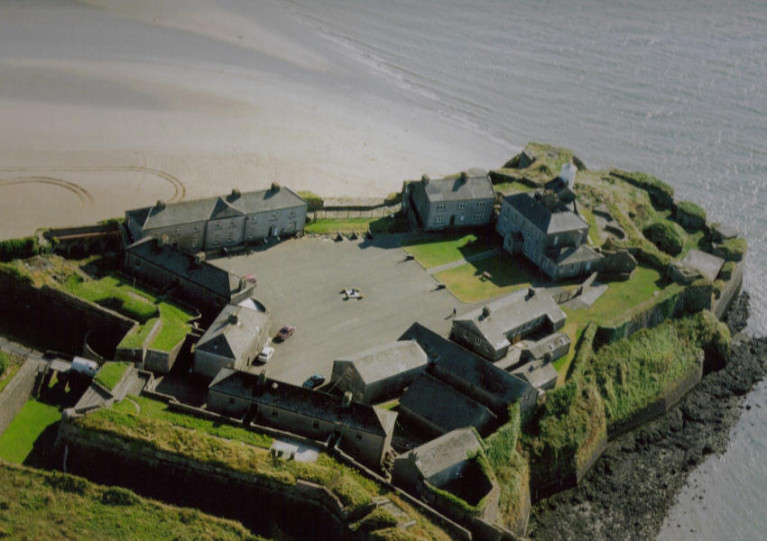
Ireland’s Heritage Minister recently got a first-hand look at the dedication of volunteers in Co Wexford involved in this year’s Coastwatch Ireland coastal survey, which concluded earlier this month.

Today, Sunday 25 October, is the last day to submit data for this year’s autumn survey.

As the Gorey Guardian reports, Malcolm Noonan TD was at Duncannon Fort to learn about the importance of the Waterford Estuary — as well as management and fisheries plans for the area.

These would involve local fishermen returning to “heritage fishing gear and methods” in efforts to sustainably manage a key resource in Ireland’s South East.

The estuary has been a key issue for Coastwatch Ireland, which earlier this year welcomed a High Court decision to ban dredging for razor shells without a proper environmental assessment.

The Gorey Guardian has much more on the story HERE.

Published in Environment

Coastwatch has welcomed a High Court decision closing the Waterford estuary to razor shell dredging without proper environmental assessment.

The ruling has implications for fishing activity on marine sites which are designated as Natura 2000 locations, Coastwatch director Karin Dubksy has said.

The High Court ruling issued last week quashes permission to dredge for razor shells in the Waterford estuary.

The ruling says that the decision to permit the activity was made without screening or appropriate assessment under Article 6(3) of the EU Habitats Directive to check if there is no adverse impact on the integrity of the site.

Last September, Coastwatch secured a temporary injunction preventing fishing for razor clams in the Waterford estuary, pending the outcome of a legal challenge.

It took proceedings against the Sea Fisheries Protection Agency (SFPA), the Minister for Agriculture, Food and the Marine, Ireland and the Attorney General.

Ms Dubsky said that the final ruling delivered on July 13th involves an undertaking that the Minister will agree to review the Sea Fisheries Regulations statutory instrument 290/2013 by November 30th this year.

This would ensure that Irish law “fully transposes the requirements of EU environmental law and, in particular, the EU Habitats Directive”, she said.

“Coastwatch will be entitled to make submissions to this review,” she said, and the State is responsible for the non-governmental organisation’s costs in the legal case.

“There has been too much optimism that the sea will cope with almost every private or corporate use anyone comes up with. The sea can’t and we need to protect it,” Ms Dubsky said.

“On top of that, climate change is already impacting on estuarine and coastal ecosystems. A hot spell can cause local mass death of organisms. There aren’t enough marine protected areas (MPAs) as connected safe havens to support species survival and those we have aren’t managed properly,” she said.

“The new Programme for Government sets out some positive plans, and with COVID payments and changes in markets, there is a real opportunity now to restructure and focus on ocean health,” she said.

“ We should support creation of marine protected areas, restoration and management plans and traditional low impact fisheries with locally designed closed areas,” she said.

The Department of Agriculture, Food and Marine said it was pleased that the case had been brought to a “satisfactory conclusion by means of an agreed settlement”.

It said that “while a commitment to review the Sea Fisheries Regulations SI 290 of 2013 does not form part of the settlement submitted to the High Court, the department has committed to undertake a review of SI 290 of 2013 by November 30th this year”.
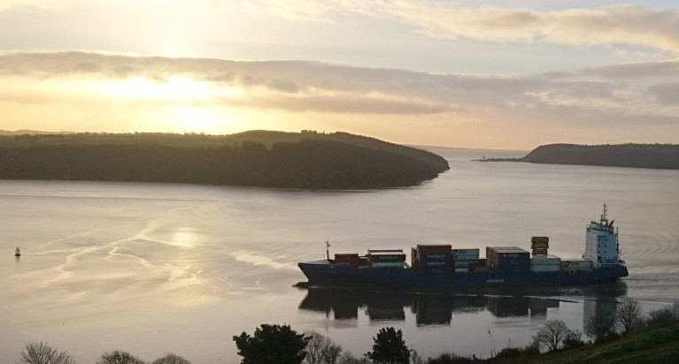
Published in Coastal Notes

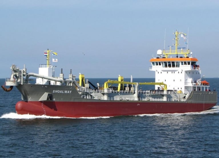
A maintenance dredging campaign has begun in recent days at the Port of Waterford where activities will involve the waters of Duncannon Bar, Cheekpoint, and at the port's main terminal at Belview, writes Jehan Ashmore

Prior to the operations at the south-east port, the Cypriot flagged Shoalway, a trailing suction hopper dredger had been carrying out operations for the Dublin Port Company. Shoalway sailed from the capital to arrive on the Waterford Estuary on Sunday. 

According to the Port of Waterford (click to consult campaign notice here), the dredger will dispose spoil at an approved site south west of Hook Head, Co. Wexford. Dredging will be followed by a bed levelling campaign by the vessels, Fastnet Sound and or the Glenesk.

Afloat adds that Irish Dredging which is a subsidiary of Royal Boskalis Westminster nv, the world’s largest dredging group, was given the contract from the Port of Waterford. The extensive fleet of the Dutch group provides Irish Dredging access to the use a of wide range of vessels for projects around the Irish coast.

Further tracking of the Shoalway since introduction on the Waterford Estaury has seen the 90m long dredger kept busy between Cheekpoint to the spoiling grounds out to sea.

The campaign according to the Port of Waterford is expected to last approximately 24 days.

Published in Dredging

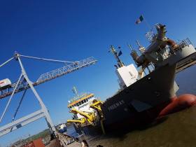
#Irishports - The Port of Waterford have issued a Marine Notice in recent days to advise all ship owners, shipmasters, agents, fishing vessels, pleasure craft users, seafarers and fishery organisations of a dredging campaign, writes Jehan Ashmore.

The dredging operation along Waterford Estuary began in mid-March and according to the south-east multi-modal Port the campaign will continue until around 6 April.

Carrying out these works is the task of trailing suction hopper dredger Freeway which will conduct dredging activities in the vicinity of Belview Port. The lo-lo facility located downriver of Waterford City is the main port along the estuary.

Freeway is operated by UK firm, Royal Boskalis Westminster based in Hampshire. They are no strangers to these waters having been contracted previously by the port and more recently from the Dublin Port Company. Due to berth capacity constraints the 92m dredger during December had to dock in Dun Laoghaire Harbour.

On this occasion, Freeway's role on Waterford Estuary will include duties carried off Cheekpoint and at the Duncannon Bar located further downriver and beyond where the Passage East ferry links to Ballyhack.

Disposal material from Freeway will take place at an approved site south west of Hook Head. Following such work a bed-levelling campaign will be assigned to the Waterford City based catamaran craft Fastnet Sound.

Published in Dredging

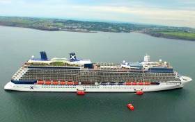
#Cruiseliners - Anchored off Dunmore East, Waterford Estuary this morning is the 'Solstice' class Celebrity Silhouette, which had sailed overnight from Cork (Cobh) Harbour, writes Jehan Ashmore.

Dunmore East, a fishing harbour village set in beautiful surroundings is a gateway for cruise visitors. Tenders from the Celebrity Cruises ship are is use to disembark those ashore and begin exploring the local attractions and activities. In addition the south-east region offers destinations beyond Waterford in the neighbouring counties.

Asides today's call by Celebrity Silhouette, Port of Waterford is set to welcome a further four cruisecallers with Azamara Pursuit due next on August 26th. The remaining trio call next month, marking the season's end. Brillance of the Seas is scheduled on September 3rd, Ocean Majesty on the 4th and the concluding caller will be Nautica on the 24th.

Afloat has calculated the total passenger capacity of the quartet of cruiseships to be 4,475 passengers. Based from this, the call of Celebrity Silhouette, given its capacity of 2,850 alone clearly demonstrates the importance of these considerably larger cruiseships to Waterford estuary. Smaller cruisecallers though with potentially high-spending clientele, head to Belview Port and upriver on the Suir along Waterford City quays.  

According to the recently published Dept. of Transport's: Transport Trends report, the cruiseship sector is an increasingly important element of maritime activity in Irish waters. The number of cruiseship visits grew by 12% from 209 in 2016 to 234 in 2017, while the number of cruise ship passengers rose by 19% to 264,763 in 2017.

The call of the 122,000 tonnes Celebrity Silhouette is a boost to the local ecomony as the Port of Waterford has faired less compared to other ports. This was a conclusion drawn from the report, as Waterford had 37% fewer cruise passengers last year than in 2016 at 4,710.

Not suprisingly, the larger main ports of Dublin and Cork dominated the cruiseship market in 2017. According to CSO figures compiled in the report, these ports combined hosted 83% of ship visits and 93% of the passengers.

Among the callers to Dublin Port this season, is Celebrity Silhouette which notably for the first time was homeported in the capital port. As reported earlier this year, the US based Celebrity Cruises was estimated to handle over 14,000 people start their holiday from Dublin Port. The Maltese flagged ship easily became the largest such cruiseship to do.

The concept of homeporting in Dublin Port is not unique as last year, the capital port welcomed Cruise & Maritime Voyages 46,000 tonnes Magellan. The 1,250 passenger cruiseship continues this season to offer direct no-fly cruises.

In addition the Bahamas flagged Magellen makes a new departure this year as CMV will from next month also offer direct cruises from Cork.

In May and June 2019, Celebrity are to deploy Celebrity Reflection which is scheduled to sail from Dublin as part of a mini-season offering five cruises from Ireland.

Published in Cruise Liners
Tagged under

#NewFlagship - Half of all cruiseship calls to visit Waterford Estuary are due in the first of a three-month season in which Afloat has identified to include a brand new cruiseship, writes Jehan Ashmore.

According to the cruiseship line-up for 2017, Afloat has noted that eight out of a total of 16 cruiseships are to visit the south-east region in the opening month of June. The leaves the balance of four cruiseships to call in August and equally the same number for the concluding month of September. 

The Port of Waterford has terminals dotted on the estuary where 1,000 years ago Viking longboats headed upriver to firmly establish a trading port. This established Ireland's oldest city. In more recent centuries the city became world famous for its crystal making traditions. A popular tourist attraction as well as to the manor estate gardens on the environs of the city. 

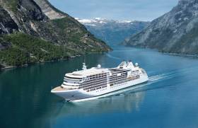
Brand New Cruiseship Call

As referred above Afloat has identified the call of a brand new cruiseship which is to be the Silver Muse, the flagship of Monaco based Silverseas Cruises. The 40,700 gross tonnage newbuild accommodates 596 guests in ultra-luxurious facilities. The newcomer is an exciting evolution of their Silver Spirit.

Afloat will have more to report on Silver Muse which will make a pre-inaugural voyage in home seas next month on a round trip voyage from Monte-Carlo of Mediterranean gems. Among them calls to quintessential destinations such as Barcelona, Palma and Portofino.

As for the first to caller to Waterford in early June is Artania. Pheonix Reissen, the German operators of the ship which would be more familiar to most as the original Royal Princess completed in 1984 for US based Princess Cruises. The 44,500 tonnes Artania with a 1,100 passenger capacity has been allocated an anchorage call off Dunmore East.

The predominant fishing harbour at the entrance to the estuary is where a further seven cruise callers will too be making an anchorage call.

Ultra luxury small-cruiseship Hebridean Sky of Noble Caledonia, is to call twice. Firstly calling in June at Belview, the main cargo (mostly lo-lo containers) terminal for the Port of Waterford.

On the second call in August, the diminutive sized ship is expected to head upriver to the city quays. The 4,200 tonnes ship is to berth along Frank Cassin Wharf, the former Bell Lines lo-lo terminal.

Published in Cruise Liners

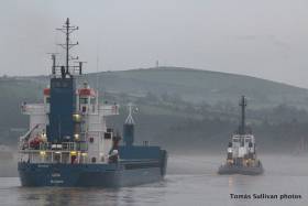
#Cargoships - One of Arklow Shipping’s newest cargoships, the single-hold Arklow Cape is today docked on the River Suir at Belview the Port of Waterford, writes Jehan Ashmore.

The Irish flagged 5,053dwt newbuild with Arklow as a port of registry, was launched in October last year and delivered into service the following month. The ‘C’’ class vessel is the second of a 10-ship order from Ferus Smit’s Dutch yard in Westerbroek.

Arklow Cape departed from Bayonne on the French Atlantic coast and the voyage took two days to reach Waterford Estuary. The newbuild arrived yesterday evening to Belview Terminal, downriver of Waterford City.

In the career of Arklow Cape typical cargoes will include grain to be carried in a ship that measures 87m in length overall and is a similar size to cargoship Lisa. The 89m vessel dating to 2001, however while on the neighbouring River Barrow more than a week ago got into difficulties having grounded.

Fortunately all crew were safe following the incident which saw the cargoship become stuck on a mud-bank south of the Pink Rock. The location is between the disused Barrow Railway Bridge and New Ross Port, the ship's destination.

Tugs were dispatched to the scene from Waterford based operator, Fastnet Shipping. Among the tugs involved was the 25 ton bollard pull tug Bargarth which came to the aid of the St. John's registered cargoship. 

The undamaged Lisa was refloated and was able to continue the short leg upriver to the inland port to discharge a 4,500 tonne dry cargo.

After an inspection by maritime authorities, the cargoship was permitted to set sail.

Published in Ports & Shipping

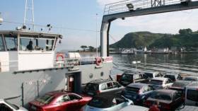
#FerryOffService - The Passage East Ferry service on Waterford Estuary has been suspended until next Monday (14th March) due to maintenance, according to AA Roadwatch.

FBD Tintern is currently off service as otherwise Afloat adds the 130 passenger/30 vehicle capacity ferry serves the River Suir crossing linking the villages of Ballyhack in Co. Wexford and Passage East in Co. Waterford.

The short passage only takes around 15 minutes and with an average of 120 crossings every day keeps the 236 tonnes FBD Tintern busy, notably during peak commuter times and in the summer.

The present car ferry service began in 1982 when the Dunbrody replaced a small boat ferry service that had been in place for hundreds of years. In January, the ferry business was reported as up for sale. 

Published in Ferry
Page 1 of 3

General Information on using Waterways Ireland inland navigations

Safety on the Water

All users of the navigations are strongly recommended to make themselves aware of safety on the water for whatever activity they are involved in and to read the advice offered by the various governing bodies and by:

The Dept. of Transport, Ireland: www.gov.ie/transport and The Maritime and Coastguard Agency, UK, The RNLI – Water Safety Ireland for information in terms of drowning prevention and water safety.

Registration of Vessels

All vessels using the Shannon Navigation, which includes the Shannon-Erne Waterways and the Erne System must be registered with Waterways Ireland. Only open undecked boats with an engine of 15 horsepower or less on the Shannon Navigation, and vessels of 10 horsepower or less on the Erne System, are exempt. Registration is free of charge.

Craft registration should be completed online at: https://www.waterwaysireland.org/online-services/craft-registration

Permits for use of the Grand and Royal Canals and the Barrow Navigation

All vessels using the Grand and Royal Canals and the Barrow Navigation must display appropriate valid Permit(s) i.e A Combined Mooring and Passage Permit (€126) and if not intending to move every five days, an Extended Mooring Permit (€152).

Permit applications should be completed online at: https://www.waterwaysireland.org/online-services/canal-permits

Passage on the Royal and Grand Canals – Dublin Area

For boat passage through the locks east of Lock 12 into / out of Dublin on either the Royal or Grand Canals, Masters are requested to contact the Waterways Ireland Eastern Regional Office (M-F 9.30am-4.30pm) on tel: +353(0)1 868 0148 or email [email protected] prior to making passage in order to plan the necessary lock-keeping assistance arrangements.

On the Grand Canal a minimum of two days notice prior to the planned passage should be given, masters should note that with the exception of pre-arranged events, a maximum of 2 boats per day will be taken through the locks, travelling either east or west.

Movements in or out of the city will be organised by prior arrangement to take place as a single movement in one day. Boaters will be facilitated to travel the system if their passage is considered to be safe by Waterways Ireland and they have the valid permit(s) for mooring and passage.

Newcomen Lifting Bridge

On the Royal Canal two weeks’ notice of bridge passage (Newcomen Lifting Bridge) is required for the pre-set lift date, and lock assistance will then also be arranged. A minimum of 2 boats is required for a bridge lift to go ahead.

Waterways Ireland Eastern Regional Office (Tel: +353(0)1 868 0148 or [email protected] ) is the point of contact for the bridge lift.

A maximum number of boats passing will be implemented to keep to the times given above for the planned lifts (16 for the Sat / Sun lifts & 8 for the weekday lifts). Priority will be given on a first come first served basis.

On day of lift, boaters and passengers must follow guidance from Waterways Ireland staff about sequence of passage under bridge & through Lock 1, and must remain within signed and designated areas.

Events Held on the Waterways

All organised events taking place on the waterways must have the prior approval of Waterways Ireland. This is a twelve week process and application forms must be accompanied with the appropriate insurance, signed indemnity and risk assessment. The application should be completed on the Waterways Ireland events page at :

https://www.waterwaysireland.org/online-services/event-approval

Time Limits on Mooring in Public Harbours

On the Shannon Navigation and the Shannon-Erne Waterway craft may berth in public harbours for five consecutive days or a total of seven days in any one month.

On the Erne System, revised Bye Laws state that: No master or owner shall permit a vessel, boat or any floating or sunken object to remain moored at or in the vicinity of any public mooring, including mooring at any other public mooring within 3 kilometres of that location, for more than 3 consecutive days and shall not moor at that same mooring or any other public mooring within 3 kilometres of that location within the following 3 consecutive days without prior permission by an authorised official.

Winter Mooring on the Shannon Navigation and Shannon Erne Waterway

Winter mooring may be availed of by owners during the period 1 Nov to 31 Mar by prior arrangement and payment of a charge of €63.50 per craft. Craft not availing of Winter Mooring must continue to comply with the “5 Day Rule”. Winter Mooring applications should be completed online at : https://www.waterwaysireland.org/online-services/winter-moorings-booking

Owners should be aware that electricity supply and water supply to public moorings is disconnected for the winter months. This is to protect against frost damage, to reduce running costs and to minimise maintenance requirements during the winter months.

Vessel owners are advised that advance purchasing of electricity on the power bollards leading up to the disconnection date should be minimal. Electricity credit existing on the bollards will not be recoverable after the winter decommissioning date. Both services will be reinstated prior to the commencement of the next boating season.

Smart Cards

Waterways Ireland smart cards are used to operate locks on the Shannon Erne Waterway, to access the service blocks, to use the pump-outs along the navigations, to avail of electrical power at Waterways Ireland jetties.

Berthing in Public Harbours

Masters are reminded of the following:

  • Equip their vessel with mooring lines of appropriate length and strength and only secure their craft to mooring bollards and cleats provided for this purpose.
  • Ensure the available berth is suitable to the length of your vessel, do not overhang the mooring especially on finger moorings on floating pontoon moorings.
  • Ensure mooring lines, electric cables and fresh water hoses do not create a trip hazard on public jetties for others users.
  • Carry sufficient fenders to prevent damage to your own vessel, other vessels and WI property.
  • Allow sufficient space between your vessel and the vessel ahead /astern (c.1m) for fire safety purposes and /or to recover somebody from the water.
  • Do not berth more than two vessels side by side and ensure there is safe access/egress at all times between vessels and onto the harbour itself.
  • Do not berth in such a way to prevent use of harbour safety ladders, slipways or pump-outs.
  • Do not allow the bow of your vessel to overhang the walkway of a floating mooring thus creating a hazard for others with an overhanging anchor or bow fendering.
  • Animals are not allowed to be loose or stray at any time.
  • Harbour and jetty infrastructure such as railings, power pedestals, fresh water taps, electric light poles, safety bollards, ladders etc are not designed for the purpose of mooring craft , they will not bear the strain of a vessel and will be damaged.
  • At Carrybridge on the Erne System, Masters of vessels are not permitted to use stern on mooring. Masters of vessels must use the mooring fingers for mooring of vessels and for embarkation / disembarkation from vessels.

Passenger Vessel Berths

Masters of vessels should not berth on passenger vessel berths where it is indicated that an arrival is imminent. Passenger vessels plying the navigations generally only occupy the berths to embark and disembark passengers and rarely remain on the berths for extended periods or overnight.

Lock Lead-in Jetties

Lead-in jetties adjacent to the upstream and downstream gates at lock chambers are solely for the purpose of craft waiting to use the lock and should not be used for long term berthing.

Vessel Wake

Vessel wake, that is, the wave generated by the passage of the boat through the water, can sometimes be large, powerful and destructive depending on the hull shape and engine power of the vessel. This wake can be detrimental to other users of the navigation when it strikes their craft or inundates the shoreline or riverbank. Masters are requested to frequently look behind and check the effect of their wake / wash particularly when passing moored vessels, on entering harbours and approaching jetties and to be aware of people pursuing other activities such as fishing on the riverbank.

Speed Restriction

A vessel or boat shall not be navigated on the Shannon Navigation at a speed in excess of 5 kph when within 200 metres of a bridge, quay, jetty or wharf, when in a harbour or canal or when passing within 100 metres of a moored vessel or boat.

Vessels navigating the Shannon-Erne Waterway should observe the general 5 kph speed limit which applies along the waterway. This is necessary in order to prevent damage to the banks caused by excessive wash from vessels.

Vessels navigating the Erne System should observe the statutory 5kt / 6mph / 10kph speed limit areas.

A craft on the Royal and Grand canals shall not be navigated at a speed in excess of 6km per hour.

A craft on the Barrow Navigation shall not be navigated at a speed in excess of 11km per hour except as necessary for safe navigation in conditions of fast flow.

Bank Erosion

Narrow sections of all the navigations are particularly prone to bank erosion due to the large wash generated by some craft. Masters are requested to be vigilant and to slow down to a speed sufficient to maintain steerage when they observe the wash of their craft inundating the river banks.

Unusual Waterborne Activity

Unusual waterborne vessels may be encountered from time to time, such as, hovercraft or amphibious aircraft / seaplanes. Masters of such craft are reminded to apply the normal “Rule of the Road” when they meet conventional craft on the water and to allow extra room to manoeuvre in the interest of safety.

Sailing Activity

Mariners will encounter large numbers of sailing dinghies from late June to August in the vicinity of Lough Derg, Lough Ree and Lower Lough Erne. Sailing courses are marked by yellow buoys to suit weather conditions on the day. Vessels should proceed at slow speed and with due caution and observe the rules of navigation when passing these fleets, as many of the participants are junior sailors under training.

Rowing

Mariners should expect to meet canoes and vessels under oars on any part of the navigations, but more so in the vicinity of Athlone, Carrick-on-Shannon, Coleraine, Enniskillen and Limerick. Masters are reminded to proceed at slow speed and especially to reduce their wash to a minimum when passing these craft as they can be easily upset and swamped due to their very low freeboard and always be prepared to give way in any given traffic situation.

Canoeing

Canoeing is an adventure sport and participants are strongly recommended to seek the advice of the sport’s governing bodies i.e Canoeing Ireland and the Canoe Association of Northern Ireland, before venturing onto the navigations.

Persons in charge of canoes are reminded of the inherent danger to these craft associated with operating close to weirs, sluice gates, locks and other infrastructure particularly when rivers are in flood and large volumes of water are moving through the navigations due to general flood conditions or very heavy localised precipitation e.g. turbulent and broken water, stopper waves. Shooting weirs is prohibited without prior permission of Waterways Ireland.

Canoeists should check with lockkeepers prior entering a lock to ensure passage is done in a safe manner. Portage is required at all unmanned locks.

Canoe Trail Network – "Blueways"

Masters of powered craft are reminded that a canoe trail network is being developed across all navigations and to expect more organised canoeing along these trails necessitating slow speed and minimum wash when encountering canoeists, rowing boats etc

Rockingham and Drummans Island Canals – Lough Key

It is expected that work on Rockingham and Drummans Island Canals on Lough Key will be completed in 2021. Access to these canals will be for non-powered craft only, eg canoes, kayaks, rowing boats.

Fast Powerboats and Personal Watercraft (Jet Skis)

Masters of Fast Powerboats (speed greater than 17kts) and Personal Watercraft (i.e.Jet Skis) are reminded of the inherent dangers associated with high speed on the water and especially in the confines of small bays and narrow sections of the navigations. Keeping a proper look-out, making early alterations to course and /or reducing speed will avoid conflict with slower vessels using the navigation. Personal Watercraft are not permitted to be used on the canals.

Towing Waterskiers, Wakeboarders, Doughnuts etc

Masters of vessels engaged in any of these activities are reminded of the manoeuvring constraints imposed upon their vessel by the tow and of the added responsibilities that they have to the person(s) being towed. These activities should be conducted in areas which are clear of conflicting traffic. It is highly recommended that a person additional to the master be carried to act as a “look-out” to keep the tow under observation at all times.

Prohibition on Swimming

Swimming in the navigable channel, particularly at bridges, is dangerous and is prohibited due to the risk of being run over by a vessel underway in the navigation.

Age Restrictions on operating of powered craft

In the Republic of Ireland, Statutory Instrument 921 of 2005 provides the legal requirements regarding the minimum age for operating of powered craft. The Statutory Instrument contains the following requirements:

- The master or owner of a personal watercraft or a fast power craft shall take all reasonable steps to ensure that a person who has not attained the age of 16 years does not operate or control the craft

- The master or owner of a pleasure craft powered by an engine with a rating of more than 5 horse power or 3.7 kilowatts shall take all reasonable steps to ensure that a person who has not attained the age of 12 years does not operate or control the craft.

Lifejackets and Personal Flotation Devices (PFDs)

Lifejackets and PFD’s are the single most important items of personal protective equipment to be used on a vessel and should be worn especially when the vessel is being manoeuvred such as entering / departing a lock, anchoring, coming alongside or departing a jetty or quayside.

In the Republic of Ireland, Statutory Instrument 921 of 2005 provides the legal requirements regarding the wearing of Personal Flotation Devices. The Statutory Instrument contains the following requirements:

- The master or owner of a pleasure craft (other than a personal watercraft) shall ensure, that there are, at all times on board the craft, sufficient suitable personal flotation devices for each person on board.

- A person on a pleasure craft (other than a personal watercraft) of less than 7 metres length overall shall wear a suitable personal flotation device while on board an open craft or while on the deck of decked craft, other than when the craft is made fast to the shore or at anchor.

- The master or owner of a pleasure craft (other than a personal watercraft) shall take all reasonable steps to ensure that a person who has not attained the age of 16 years complies with paragraph above.

- The master or owner of a pleasure craft (other than a personal watercraft), shall take all reasonable steps to ensure that a person who has not attained the age of 16 years wears a suitable personal flotation device while on board an open craft or while on the deck of a decked craft other than when it is made fast to the shore or at anchor.

- The master or owner of a pleasure craft (other than a personal watercraft) shall take all reasonable steps to ensure that a person wears a suitable personal flotation device, at all times while – (a) being towed by the craft, (b) on board a vessel or object of any kind which is being towed by the craft.

Further information is available at: http://www.irishstatutebook.ie/eli/2005/si/921/made/en/print

Firing Range Danger Area – Lough Ree

The attention of mariners is drawn to the Irish Defence Forces Firing Range situated in the vicinity of buoys No’s 2 and 3, on Lough Ree on the Shannon Navigation. This range is used regularly for live firing exercises, throughout the year, all boats and vessels should stay clear of the area marked with yellow buoys showing a yellow "X" topmark and displaying the word "Danger".

Shannon Navigation, Portumna Swing Bridge Tolls

No attempt should be made by Masters’ of vessels to pay the bridge toll while making way through the bridge opening. Payment will only be taken by the Collector from Masters when they are secured alongside the jetties north and south of the bridge.

Navigating from Killaloe to Limerick on the Shannon Navigation

The navigation from Killaloe to Limerick involves passage through Ardnacrusha locks, the associated headrace and tailrace and the Abbey River into Limerick City. Careful passage planning is required to undertake this voyage. Considerations include: lock passage at Ardnacrusha, water flow in the navigation, airdraft under bridges on Abbey River in Limerick, state of tide in Limerick

Users are advised to contact the ESB Ardnacrusha hydroelectric power station (00353 (0)87 9970131) 48 hours in advance of commencing their journey to book passage through the locks at Ardnacrusha. It is NOT advised to undertake a voyage if more than one turbine is operating (20MW), due to the increased velocity of flow in the navigation channel, which can be dangerous. To ascertain automatically in real time how many turbines are running, users can phone +353 (0)87 6477229.

For safety reasons the ESB has advised that only powered craft with a capacity in excess of 5 knots are allowed to enter Ardnacrusha Headrace and Tailrace Canals.

Passage through Sarsfield Lock should be booked on +353-87-7972998, on the day prior to travel and it should be noted also that transit is not possible two hours either side of low water.

A Hydrographic survey in 2020 of the navigation channel revealed that the approach from Shannon Bridge to Sarsfield Lock and the Dock area has silted up. Masters of vessels and water users are advised to navigate to the Lock from Shannon bridge on a rising tide one or two hours before High Tide.

Lower Bann Navigation

The attention of all users is drawn to the “Users Code for the Lower Bann”, in particular to that section covering “Flow in the River” outlining the dangers for users both on the banks and in the navigation, associated with high flow rates when the river is in spate. Canoeists should consult and carry a copy of the “Lower Bann Canoe Trail” guide issued by the Canoe Association of Northern Ireland. Users should also contact the DfI Rivers Coleraine, who is responsible for regulating the flow rates on the river, for advisory information on the flow rates to be expected on any given day.

DfI Rivers Coleraine. Tel: 0044 28 7034 2357 Email: [email protected]

Lower Bann Navigation – Newferry – No wake zone

A No Wake Zone exists on the Lower Bann Navigation at Newferry. Masters of vessels are requested to proceed at a slow speed and create no wake while passing the jetties and slipways at Newferry.

Overhead Power Lines (OHPL) and Air draft

All Masters must be aware of the dangers associated with overhead power lines, in particular sailing vessels and workboats with cranes or large air drafts. Voyage planning is a necessity in order to identify the location of overhead lines crossing the navigation.

Overhead power line heights on the River Shannon are maintained at 12.6metres (40 feet) from Normal Summer level for that section of navigation, masters of vessels with a large air draft should proceed with caution and make additional allowances when water levels are high.

If a vessel or its equipment comes into contact with an OHPL the operator should NOT attempt to move the vessel or equipment. The conductor may still be alive or re-energise automatically. Maintain a safe distance and prevent third parties from approaching due to risk of arcing. Contact the emergency services for assistance.

Anglers are also reminded that a minimum ground distance of 30 metres should be maintained from overhead power lines when using a rod and line.

Submarine Cables and Pipes

Masters of vessels are reminded not to anchor their vessels in the vicinity of submarine cables or pipes in case they foul their anchor or damage the cables or pipes. Look to the river banks for signage indicating their presence.

Water Levels - Precautions

Low Water Levels:

When water levels fall below normal summer levels masters should be aware of:

Navigation

To reduce the risk of grounding masters should navigate on or near the centreline of the channel, avoid short cutting in dog-legged channels and navigating too close to navigation markers.

Proceeding at a slow speed will also reduce “squat” effect i.e. where the vessel tends to sit lower in the water as a consequence of higher speed.

Slipways

Reduced slipway length available under the water surface and the possibility of launching trailers dropping off the end of the concrete apron.

More slipway surface susceptible to weed growth requiring care while engaged in launching boats, from slipping and sliding on the slope. Note also that launching vehicles may not be able to get sufficient traction on the slipway once the craft is launched to get up the incline.

Bank Erosion

Very dry riverbanks are more susceptible to erosion from vessel wash.

Lock Share

Maximising on the number of vessels in a lock will ensure that the total volume of water moving downstream is decreased. Lock cycles should be used for vessels travelling each way.

High Water Levels:

When water levels rise above normal summer level masters should be aware of:

Navigation

Navigation marks will have reduced height above the water level or may disappear underwater altogether making the navigable channel difficult to discern.

In narrow sections of the navigations water levels will tend to rise more quickly than in main streams and air draft at bridges will likewise be reduced.

There will also be increased flow rates particularly in the vicinity of navigation infrastructure such as bridges, weirs, locks etc where extra care in manoeuvring vessels will be required.

Harbours and Jetties

Due care is required in harbours and at slipways when levels are at or near the same level as the harbour walkways' as the edge will be difficult to discern especially in reduced light conditions. It is advised that Personal Flotation Devices be worn if tending to craft in a harbour in these conditions.

Slipways

Slipways should only be used for the purpose of launching and recovering of water craft or other objects from the water. Before using a slipway it should be examined to ensure that the surface has sufficient traction/grip for the intended purpose such as launching a craft from a trailer using a vehicle, that there is sufficient depth of water on the slipway to float the craft off the trailer before the concrete apron ends and that the wheels of the trailer do not drop off the edge of the slipway. That life-saving appliances are available in the vicinity, that the vehicle is roadworthy and capable of coping with the weight of the trailer and boat on the incline. It is recommended that slipway operations are conducted by two persons.

Caution to be Used in Reliance upon Aids to Navigation

The aids to navigation depicted on the navigation guides comprise a system of fixed and floating aids to navigation. Prudent mariners will not rely solely on any single aid to navigation, particularly a floating aid to navigation. With respect to buoys, the buoy symbol is used to indicate the approximate position of the buoy body and the ground tackle which secures it to the lake or river bed. The approximate position is used because of the practical limitations in positioning and maintaining buoys in precise geographical locations. These limitations include, but are not limited to, prevailing atmospheric and lake/river conditions, the slope of and the material making up the lake/river bed, the fact that the buoys are moored to varying lengths of chain, and the fact that the buoy body and/or ground tackle positions are not under continuous surveillance. Due to the forces of nature, the position of the buoy body can be expected to shift inside and outside the charted symbol.

Buoys and perches are also moved out of position or pulled over by those mariners who use them to moor up to instead of anchoring. To this end, mariners should always monitor their passage by relating buoy/perch positions with the published navigation guide. Furthermore, a vessel attempting to pass close by always risks collision with a yawing buoy or with the obstruction that the buoy or beacon/perch marks.

Masters of Vessels are requested to use the most up to date Navigation guides when navigating on the Inland Waterways.

Information taken from Special Marine Notice No 1 of 2023