Menu

Ireland's sailing, boating & maritime magazine

Inland afloat headers


Displaying items by tag: SmartBay

As part of this year’s events for European Maritime Day, the Marine Institute and BlueWise Marine will host a special SmartBay Observatory ‘family fun day’ this weekend.

Ahead of its redeployment in Galway Bay off the coast of An Spidéal/Spiddal, the ocean observatory will be on display at Stiúideo Cuan in the Co Galway town this Saturday 21 May from 10am to 5pm.

The day will also feature fun and educational marine workshops for all ages along with circus workshops and performances, face painting and more.

Once returned to the sea bed, the SmartBay Observatory will remain collecting scientific data 24/7. The observatory also hosts two underwater video cameras which continuously stream live footage to the public via the SmartBay website.

The SmartBay Observatory has been undergoing maintenance and upgrades in recent months and will soon be redeployed to its location 1.5km off the coast of An Spidéal in a depth of 20 meters.

“Having the rare occasion to showcase the SmartBay Observatory on land presents a unique and fascinating opportunity to learn and discover more about how we monitor the ocean,” said Alan Berry, section manager of marine research infrastructures at the Marine Institute. "We are looking forward to welcoming all to a fascinating and fun-filled day.”

To join in the fun this Saturday, be sure to RSVP to [email protected]

Published in Marine Science

An international team of scientists has demonstrated new advanced underwater technology for ocean observation at the SmartBay Observatory in Galway Bay this week.

French company SEABER demonstrated the YUCO micro-AUV (or micro autonomous underwater vehicle) — an unmanned, untethered vehicle that collects oceanographic data in coastal environments. This data is important for monitoring our marine environment and changing ocean climate.

The SmartBay Observatory is one of Ireland’s national marine scientific research facilities, providing national and international researchers with the infrastructure to validate new marine sensors and instruments in real sea conditions.

Alan Berry, manager of marine research infrastructures at the Marine Institute, said: “The SmartBay Observatory is used to validate new sensor technologies, such as SEABER’s innovative and affordable micro-AUV system.

“New marine sensor technologies increase the accessibility and availability of data for organisations monitoring our oceans and in turn contributes globally to our deeper understanding of the oceans.”

SEABER were successful through the EU JERICO-RI European Infrastructure JERICO-S3 Access Programme to utilise the SmartBay Observatory in Galway Bay.

Over the coming months, the observatory will facilitate a further four international science projects demonstrating novel and improved sensor technologies on this unique Irish research infrastructure towards the common goal of improving data collection for marine and climate observations.

Michael Gillooly, interim CEO at the Marine Institute, said: “By facilitating advanced ocean monitoring technologies, the SmartBay Observatory helps to take concepts and prototypes from laboratories into the sea.

“New marine monitoring technologies and sensors generate more data than we have ever had before, improving our ocean observation capabilities and increasing our ocean knowledge.”

For more information visit www.smartbay.ie, @SmartBaySite on Twitter and @SmartBaySite on Facebook. For more about the JERICO-S3 access programme, see the project website.

The JERICO-S3 project received funding from the European Commission’s Horizon 2020 Research and Innovation programme under grant agreements No 871153.

Published in Marine Science
Tagged under

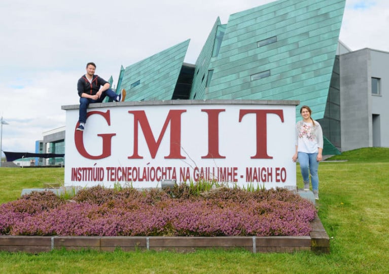
SmartBay Ireland have collaborated with the Galway-Mayo Institute of Technology (GMIT) to launch a new scholarship scheme for a candidate from the Connemara Gaeltacht to begin a Master’s research programme.

Commencing in November 2020, the new programme aims to develop post-primary educational resources in the field of marine renewable energy.

And the scholarship, which is now open for applications, is designed to fund and support a candidate in the Connemara Gaeltacht Region — while also driving awareness around ocean literacy, marine renewable energy, and sustainability through education in local schools.

The successful candidate will receive full funding support to the value of €44,500 over the duration of the 24-month project, which will focus on the preparation and delivery of educational resources at post-primary level, in both English and Irish.

SmartBay Ireland general manager John Breslin said: “This scholarship is an excellent opportunity for the successful candidate not only to advance in their career, but to be at the forefront of developing educational resources and make a positive and lasting impact on the post primary curriculum.”

Applications are open until noon next Wednesday 16 September for candidates with experience as a post-primary educator, preferably in the field of science, with demonstrable proficiency and fluency in the Irish language.

“This is a very exciting opportunity which would suit an enthusiastic candidate with a passion for education, the marine and sustainability,” said Dr Róisín Nash, a lecturer at GMIT.

“At a time when research and management of essential marine resources are key features of a sustainable future, this is a unique project with lots of opportunities for the candidate to be creative and influential in incorporating marine and renewable energy into the classroom.”

The SmartBay Ireland Postgraduate Research Scholarship is funded by the Galway-Mayo Institute of Technology, the Marine Institute, the Sustainable Energy Authority of Ireland and Údarás na Gaeltachta.

Full details on the postgraduate research scholarship and application procedure are available from GMIT website HERE.

Published in Marine Science

Seven successful applicants will be awarded funding under the Marine Institute’s SmartBay National Infrastructure Access Programme (NIAP) following the 2018/2019 funding call.

The awardees will receive support of around €25,000 per project to trial and validate their technology and/or gain access to data feeds to carry out scientific research at the SmartBay Marine and Renewable Energy Test Site in Galway Bay.

The call was open to both academia and industry, and other relevant organisations, on the island of Ireland to access the SmartBay test site and subsea observatory.

The chosen organisations may deploy equipment on the test site, connect to and access the underwater observatory, and analyse the many data feeds which are collected on site every day.

Over the past seven years, more than 50 projects have been awarded funding, facilitating a wide range of multi-disciplinary marine research, development and innovation at this national facility, the Marine Institute says.

Welcoming the announcement, the institute’s outgoing chief executive Dr Peter Heffernan said the funding awards “are aligned with the goals of the national Marine Research and Innovation Strategy 2017–2021”.

This year the following projects were awarded funding:

  • Dublin City University — Demystifying the ocean through underwater video analysis: marine life activity detection, classification and indexing for the SmartBay ocean observation platform
  • Sligo Institute of Technology — A small waterplane area twin hulled (SWATH) tide buoy with real-time kinematic (RTK) positioning for accurate (centimetre level) tide gauge calibration
  • Queen’s University Belfast — Can introduced marine infrastructure enhance the conservation of vulnerable species?
  • Dundalk Institute of Technology — Wave parameter estimation from oscillating water column pressure signal - Phase 2 electronic optimisation of the WASP
  • Galway Mayo Institute of Technology — Environmental DNA/RNA metabarcoding for monitoring marine biodiversity in Galway Bay, with particular attention to marine invasive alien species
  • Danalto Ltd — LoRaC2.4: a geolocation technology for the marine environment
  • NUI Galway — Wave resource characterisation at the Galway Bay Marine and Renewable Energy Test Site

The first projects are preparing for deployment and testing over the coming month.

SmartBay is Ireland’s national marine test and demonstration facility for the development of innovative products and services for the global maritime sector. The National Infrastructure Access Programme is funded by the Marine Institute under the Marine Research Programme with the support of the Irish Government.

Published in Marine Science
Tagged under

#Jobs - SmartBay Ireland is seeking to recruit a community liaison co-ordinator for its marine and renewable energy test site and subsea observatory in Galway Bay.

The successful candidate will have a contract with SmartBay, but the focus of the job “will be to facilitate communication between residents, community groups, schools, local businesses and interested parties with the view to increasing local understanding and support” for the SmartBay project off Spiddal.

Written and verbal fluency in both English and Irish is a requirement for this role, as is a degree or equivalent experience in community development or a related subject.

The closing date for applications is Wednesday 31 October. The full job description and details on how to apply can be found here in English, and also as Gaeilge.

Published in Jobs
Tagged under

#MarineScience - More than 70 leading marine scientists from across Europe met in Galway recently to discuss open access to research on ocean observation.

The Marine Institute in Oranmore hosted the second general assembly of the EU-funded Jerico-NEXT Project, which aims to build on the ongoing co-operation of coastal observatories in Europe — such as SmartBay in Galway — for wider application by the research community and society alike.

A fundamental tenet of the project is that coastal areas are the “most productive and dynamic environment” in the world’s oceans, according to the institute, with significant potential for renewable energy in particular.

“The Marine Institute has a longstanding commitment to the collection, processing and analysis of high quality coastal marine observations,” said the institute’s Paul Gaughan.

“In Ireland we are utilising the SmartBay coastal observatory, located 5km off Spiddal in Galway Bay, as a key component in this trans-European collaboration effort.

“From this we are able to deliver high quality information about sea conditions, subsea video and audio data in real-time to scientists around Europe to access and analyse.”

Data from the SmartBay site are freely available online.

The Marine Institute also recently hosted a delegation of officials from Kenya as part of the Memorandum of Understanding signed last year with the Kenyan Marine Fisheries Research Institute (KMFRI).

The official visit focused on developing an action plan around seven priority areas outlined in the MoU, which include plans for marine fisheries management, hydro-acoustics and assessment of pelagic fisheries resources.

Other priorities are spatial analysis and mapping of vessel monitoring system (VMS) data, integration of VMS and logbook data for fisheries management, and a data management strategy.

Opportunities for exchange, study visits and developing joint PhD and post-doctoral research projects were also a focus of discussions.

Published in Marine Science

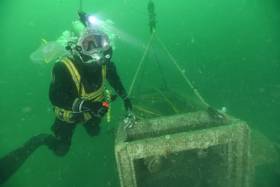
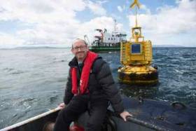
#MarineScience - The SmartBay Observatory in Galway Bay will be brought ashore for essential maintenance in the coming days.

Last week Ocean Crest Marine, with diver Mark Kerrigan, prepared for the recovery of the underwater observatory, located 1.5 km off the coast of Spiddal, which has been continuously monitoring the underwater environment over the past 15 months.

It uses cameras, instruments and sensors for continuous live underwater observations giving marine scientists and other ocean researchers unique real-time access to monitor ongoing changes in the marine environment.

Over the coming weeks, the observatory will be thoroughly cleaned, all the scientific instruments will be replaced, and new underwater lamps will be added to improve the high-definition video camera footage.

“We also plan to install a microplastics sampling net and a new underwater stills camera in partnership with European marine science researchers,” said Alan Berry of the Marine Institute.

These research projects are due to commence mid-July, when the observatory will be reinstated, to continue to collect important information on the marine environment from the depths of Galway Bay.

The SmartBay Observatory in Galway Bay contributes to a growing global network of real-time data capture systems deployed within the ocean.

Data relating to the marine environment at the site is transferred through a fibre-optic cable to the Marine Institute headquarters and onwards onto the internet.

This data includes a live video stream, the depth of the observatory node, the sea temperature and salinity, and estimates of the chlorophyll and turbidity levels in the water which give an indication of the volume of phytoplankton and other particles, such as sediment, in the water.

Published in Marine Science
Tagged under

#SmartBay - Galway's new SmartBay ocean observatory will share in a €11m European funding boost for ocean energy testing, as Silicon Republic reports.

The subsea observatory in Galway Bay – launched earlier this month in tandem with SeaFest and the Our Ocean Wealth Conference – is included along with projects in the UK, France and the Netherlands under the Funding Ocean Renewable Energy through Strategic European Action (FORESEA) programme.

SmartBay has been conceived to support the testing of quarter-scale prototypes of ocean energy devices alongside its ocean data collection capacity, which lowers the cost barriers for commercial research and development in the growing sector. Silicon Republic has more on the story HERE.

The news also comes after the signing of an energy co-operation declaration with nine other EU countries focusing on the development of wind and ocean energy, as previously reported on Afloat.ie.

Published in Power From the Sea

#SmartBay - Launching in tandem with the Our Ocean Wealth Conference in Galway today (Friday 1 July), the SmartBay Subsea Observatory will begin feeding data from the seabed at Galway Bay to businesses, researchers, scientists and policy makers.

Supported by the Marine Institute, Sustainable Energy Authority of Ireland and Science Foundation Ireland, the SmartBay Subsea Observatory is considered a key element of creating an infrastructure to support the blue economy that's critical to the success of Ireland's integrated marine plan.

Technology deployed at the observatory will be used to collect valuable data from the ocean and will be a critical component of a world-class maritime infrastructure in Ireland.

Speaking at Digital Ocean today at the Meyrick Hotel, Galway SmartBay general manager John Breslin said: "The SmartBay observatory represents the Internet of Things for the marine.

"Thanks to the extensive underwater equipment we have installed, real-time data from sensors can be accessed through the web and analysed by researchers and companies trying to commercialise novel marine technologies.

"The information from the subsea observatory will accelerate developments in the marine sector and contribute to environmental monitoring, the development of ocean energy technologies, education and research as well as maritime security. It is a hugely significant addition to Ireland¹s Digital Ocean IoT infrastructure".

In 2015, the RV Celtic Explorer was used to lay a 4km cable and a frame was installed on the seabed to which sensors and monitoring equipment were attached as part of the development of the ocean observatory.

Now for the first time, the cable will supply power to the site and allow for unlimited data transfer from the site for researchers testing new and innovative marine technologies.

"The SmartBay subsea observatory will greatly enhance our understanding of the sea, the impact of weather and climate change, and how the sea reacts in various conditions and how our man-made products will react underwater," Marine Institute chief executive Peter Heffernan.

Digital Ocean: A Pathway for Developing Ireland's Blue Economy has been is organised by the Marine Institute with the Department of Jobs, Enterprise and Innovation, IDA, Enterprise Ireland, Science Foundation Ireland, Sustainable Energy Authority of Ireland, the Irish Marine Development Office and SmartBay Ireland.

The event aims to promote Ireland's digital ocean opportunity highlighting how technology companies can drive new forms of innovation in the blue economy using Ireland as a test-bed with its significant marine resource, world-class expertise and infrastructure.

Tonight's edition of Seascapes on RTÉ Radio 1 and Afloat.ie will have more on the SmartBay project.

Published in Marine Science

#MarineScience - SmartBay Ireland has entered into a transatlantic collaboration agreement with the Fisheries and Marine Institute of Memorial University of Newfoundland in St John's, Newfoundland and Labrador, Canada, Dublin City University and the Marine Institute.

The Memorandum of Understanding was signed at a reception hosted by the Canadian Embassy during a recent Canadian trade mission to Ireland. Welcoming the agreement, Dr Peter Heffernan, CEO of the Marine Institute, said: "This is a tangible example of the type of transatlantic collaboration envisaged in the Galway Statement.

"I am especially pleased to build on the strong partnerships established with our colleagues in Newfoundland and to see the exciting collaborative opportunities in sensor technology test and demonstration for our linked SmartBay initiatives."

The agreement is designed to further consolidate and develop the partnership that exists between the marine institutes of Newfoundland and Labrador and Ireland and the SmartBay infrastructures.

Glenn Blackwood, vice-president of Memorial University, said: "Since the establishment of our marine institute, we have focused on building meaningful relationships with industry partners. This MOU solidifies our commitment to further strengthen ongoing links between SmartBay Newfoundland and Labrador and SmartBay Ireland and allows for increased collaboration on the work that both jurisdictions are conducting in the ocean industry."

The key aims of the agreement are the sharing of assets, capacity and capability in a joint mission to provide access by scientists, innovators and entrepreneurs to both SmartBay test and validation infrastructures currently deployed in the North Atlantic.

Dr Fiona Regan, director of the Marine and Environmental Sensing Technology Hub (MESTECH) and SmartBay Ireland principal investigator, added: "This exciting collaboration will enable the establishment of joint projects in the area of ocean observation with our academic and industry partners from Ireland and Canada, sharing expertise and infrastructure."

These objectives will be achieved through a range of activities including: joint industry and academic research projects; outreach and education programmes; and the identification of opportunities to leverage funding for joint research projects and the expansion of collaborative arrangements to include other jurisdictions bordering the North Atlantic.

John Breslin, general manager of SmartBay Ireland, said: "We are delighted to be working with our Canadian partners to utilise the infrastructure and expertise within both SmartBay facilities to identify and develop sensor-driven decision support tools to address specific industry needs within the oil and gas, aquaculture and telecommunications sectors."

This agreement is based on a common vision and cultural appreciation of the societal and economic value of the ocean and is another step toward the utilisation of the jurisdictions' joint facilities and expertise to deliver projects of scientific and economic benefit.

Ron Newhook, director of the Marine Institute of Newfoundland and Labrador's Office of Research and Development and Randy Gillespie, director of the institute's Centre for Applied Ocean Technology were part of the recent Newfoundland and Labrador trade mission to Ireland and attended the MOU signing.

"Capturing the spirit of the Galway Declaration, this new MOU renews and strengthens transatlantic collaborations between industry, governments, academia and NGOs," said Newhook.

"Together, SmartBay Ireland and the Marine Institute's Centre for Applied Ocean Technology, which currently operates SmartBay Newfoundland and SmartAtlantic, will lead the way in the development and implementation of a sustainable observatory which will provide information to support a safe and sustainable ocean industry in the broad North Atlantic."

Published in Marine Science
Tagged under
Page 1 of 2

General Information on using Waterways Ireland inland navigations

Safety on the Water

All users of the navigations are strongly recommended to make themselves aware of safety on the water for whatever activity they are involved in and to read the advice offered by the various governing bodies and by:

The Dept. of Transport, Ireland: www.gov.ie/transport and The Maritime and Coastguard Agency, UK, The RNLI – Water Safety Ireland for information in terms of drowning prevention and water safety.

Registration of Vessels

All vessels using the Shannon Navigation, which includes the Shannon-Erne Waterways and the Erne System must be registered with Waterways Ireland. Only open undecked boats with an engine of 15 horsepower or less on the Shannon Navigation, and vessels of 10 horsepower or less on the Erne System, are exempt. Registration is free of charge.

Craft registration should be completed online at: https://www.waterwaysireland.org/online-services/craft-registration

Permits for use of the Grand and Royal Canals and the Barrow Navigation

All vessels using the Grand and Royal Canals and the Barrow Navigation must display appropriate valid Permit(s) i.e A Combined Mooring and Passage Permit (€126) and if not intending to move every five days, an Extended Mooring Permit (€152).

Permit applications should be completed online at: https://www.waterwaysireland.org/online-services/canal-permits

Passage on the Royal and Grand Canals – Dublin Area

For boat passage through the locks east of Lock 12 into / out of Dublin on either the Royal or Grand Canals, Masters are requested to contact the Waterways Ireland Eastern Regional Office (M-F 9.30am-4.30pm) on tel: +353(0)1 868 0148 or email [email protected] prior to making passage in order to plan the necessary lock-keeping assistance arrangements.

On the Grand Canal a minimum of two days notice prior to the planned passage should be given, masters should note that with the exception of pre-arranged events, a maximum of 2 boats per day will be taken through the locks, travelling either east or west.

Movements in or out of the city will be organised by prior arrangement to take place as a single movement in one day. Boaters will be facilitated to travel the system if their passage is considered to be safe by Waterways Ireland and they have the valid permit(s) for mooring and passage.

Newcomen Lifting Bridge

On the Royal Canal two weeks’ notice of bridge passage (Newcomen Lifting Bridge) is required for the pre-set lift date, and lock assistance will then also be arranged. A minimum of 2 boats is required for a bridge lift to go ahead.

Waterways Ireland Eastern Regional Office (Tel: +353(0)1 868 0148 or [email protected] ) is the point of contact for the bridge lift.

A maximum number of boats passing will be implemented to keep to the times given above for the planned lifts (16 for the Sat / Sun lifts & 8 for the weekday lifts). Priority will be given on a first come first served basis.

On day of lift, boaters and passengers must follow guidance from Waterways Ireland staff about sequence of passage under bridge & through Lock 1, and must remain within signed and designated areas.

Events Held on the Waterways

All organised events taking place on the waterways must have the prior approval of Waterways Ireland. This is a twelve week process and application forms must be accompanied with the appropriate insurance, signed indemnity and risk assessment. The application should be completed on the Waterways Ireland events page at :

https://www.waterwaysireland.org/online-services/event-approval

Time Limits on Mooring in Public Harbours

On the Shannon Navigation and the Shannon-Erne Waterway craft may berth in public harbours for five consecutive days or a total of seven days in any one month.

On the Erne System, revised Bye Laws state that: No master or owner shall permit a vessel, boat or any floating or sunken object to remain moored at or in the vicinity of any public mooring, including mooring at any other public mooring within 3 kilometres of that location, for more than 3 consecutive days and shall not moor at that same mooring or any other public mooring within 3 kilometres of that location within the following 3 consecutive days without prior permission by an authorised official.

Winter Mooring on the Shannon Navigation and Shannon Erne Waterway

Winter mooring may be availed of by owners during the period 1 Nov to 31 Mar by prior arrangement and payment of a charge of €63.50 per craft. Craft not availing of Winter Mooring must continue to comply with the “5 Day Rule”. Winter Mooring applications should be completed online at : https://www.waterwaysireland.org/online-services/winter-moorings-booking

Owners should be aware that electricity supply and water supply to public moorings is disconnected for the winter months. This is to protect against frost damage, to reduce running costs and to minimise maintenance requirements during the winter months.

Vessel owners are advised that advance purchasing of electricity on the power bollards leading up to the disconnection date should be minimal. Electricity credit existing on the bollards will not be recoverable after the winter decommissioning date. Both services will be reinstated prior to the commencement of the next boating season.

Smart Cards

Waterways Ireland smart cards are used to operate locks on the Shannon Erne Waterway, to access the service blocks, to use the pump-outs along the navigations, to avail of electrical power at Waterways Ireland jetties.

Berthing in Public Harbours

Masters are reminded of the following:

  • Equip their vessel with mooring lines of appropriate length and strength and only secure their craft to mooring bollards and cleats provided for this purpose.
  • Ensure the available berth is suitable to the length of your vessel, do not overhang the mooring especially on finger moorings on floating pontoon moorings.
  • Ensure mooring lines, electric cables and fresh water hoses do not create a trip hazard on public jetties for others users.
  • Carry sufficient fenders to prevent damage to your own vessel, other vessels and WI property.
  • Allow sufficient space between your vessel and the vessel ahead /astern (c.1m) for fire safety purposes and /or to recover somebody from the water.
  • Do not berth more than two vessels side by side and ensure there is safe access/egress at all times between vessels and onto the harbour itself.
  • Do not berth in such a way to prevent use of harbour safety ladders, slipways or pump-outs.
  • Do not allow the bow of your vessel to overhang the walkway of a floating mooring thus creating a hazard for others with an overhanging anchor or bow fendering.
  • Animals are not allowed to be loose or stray at any time.
  • Harbour and jetty infrastructure such as railings, power pedestals, fresh water taps, electric light poles, safety bollards, ladders etc are not designed for the purpose of mooring craft , they will not bear the strain of a vessel and will be damaged.
  • At Carrybridge on the Erne System, Masters of vessels are not permitted to use stern on mooring. Masters of vessels must use the mooring fingers for mooring of vessels and for embarkation / disembarkation from vessels.

Passenger Vessel Berths

Masters of vessels should not berth on passenger vessel berths where it is indicated that an arrival is imminent. Passenger vessels plying the navigations generally only occupy the berths to embark and disembark passengers and rarely remain on the berths for extended periods or overnight.

Lock Lead-in Jetties

Lead-in jetties adjacent to the upstream and downstream gates at lock chambers are solely for the purpose of craft waiting to use the lock and should not be used for long term berthing.

Vessel Wake

Vessel wake, that is, the wave generated by the passage of the boat through the water, can sometimes be large, powerful and destructive depending on the hull shape and engine power of the vessel. This wake can be detrimental to other users of the navigation when it strikes their craft or inundates the shoreline or riverbank. Masters are requested to frequently look behind and check the effect of their wake / wash particularly when passing moored vessels, on entering harbours and approaching jetties and to be aware of people pursuing other activities such as fishing on the riverbank.

Speed Restriction

A vessel or boat shall not be navigated on the Shannon Navigation at a speed in excess of 5 kph when within 200 metres of a bridge, quay, jetty or wharf, when in a harbour or canal or when passing within 100 metres of a moored vessel or boat.

Vessels navigating the Shannon-Erne Waterway should observe the general 5 kph speed limit which applies along the waterway. This is necessary in order to prevent damage to the banks caused by excessive wash from vessels.

Vessels navigating the Erne System should observe the statutory 5kt / 6mph / 10kph speed limit areas.

A craft on the Royal and Grand canals shall not be navigated at a speed in excess of 6km per hour.

A craft on the Barrow Navigation shall not be navigated at a speed in excess of 11km per hour except as necessary for safe navigation in conditions of fast flow.

Bank Erosion

Narrow sections of all the navigations are particularly prone to bank erosion due to the large wash generated by some craft. Masters are requested to be vigilant and to slow down to a speed sufficient to maintain steerage when they observe the wash of their craft inundating the river banks.

Unusual Waterborne Activity

Unusual waterborne vessels may be encountered from time to time, such as, hovercraft or amphibious aircraft / seaplanes. Masters of such craft are reminded to apply the normal “Rule of the Road” when they meet conventional craft on the water and to allow extra room to manoeuvre in the interest of safety.

Sailing Activity

Mariners will encounter large numbers of sailing dinghies from late June to August in the vicinity of Lough Derg, Lough Ree and Lower Lough Erne. Sailing courses are marked by yellow buoys to suit weather conditions on the day. Vessels should proceed at slow speed and with due caution and observe the rules of navigation when passing these fleets, as many of the participants are junior sailors under training.

Rowing

Mariners should expect to meet canoes and vessels under oars on any part of the navigations, but more so in the vicinity of Athlone, Carrick-on-Shannon, Coleraine, Enniskillen and Limerick. Masters are reminded to proceed at slow speed and especially to reduce their wash to a minimum when passing these craft as they can be easily upset and swamped due to their very low freeboard and always be prepared to give way in any given traffic situation.

Canoeing

Canoeing is an adventure sport and participants are strongly recommended to seek the advice of the sport’s governing bodies i.e Canoeing Ireland and the Canoe Association of Northern Ireland, before venturing onto the navigations.

Persons in charge of canoes are reminded of the inherent danger to these craft associated with operating close to weirs, sluice gates, locks and other infrastructure particularly when rivers are in flood and large volumes of water are moving through the navigations due to general flood conditions or very heavy localised precipitation e.g. turbulent and broken water, stopper waves. Shooting weirs is prohibited without prior permission of Waterways Ireland.

Canoeists should check with lockkeepers prior entering a lock to ensure passage is done in a safe manner. Portage is required at all unmanned locks.

Canoe Trail Network – "Blueways"

Masters of powered craft are reminded that a canoe trail network is being developed across all navigations and to expect more organised canoeing along these trails necessitating slow speed and minimum wash when encountering canoeists, rowing boats etc

Rockingham and Drummans Island Canals – Lough Key

It is expected that work on Rockingham and Drummans Island Canals on Lough Key will be completed in 2021. Access to these canals will be for non-powered craft only, eg canoes, kayaks, rowing boats.

Fast Powerboats and Personal Watercraft (Jet Skis)

Masters of Fast Powerboats (speed greater than 17kts) and Personal Watercraft (i.e.Jet Skis) are reminded of the inherent dangers associated with high speed on the water and especially in the confines of small bays and narrow sections of the navigations. Keeping a proper look-out, making early alterations to course and /or reducing speed will avoid conflict with slower vessels using the navigation. Personal Watercraft are not permitted to be used on the canals.

Towing Waterskiers, Wakeboarders, Doughnuts etc

Masters of vessels engaged in any of these activities are reminded of the manoeuvring constraints imposed upon their vessel by the tow and of the added responsibilities that they have to the person(s) being towed. These activities should be conducted in areas which are clear of conflicting traffic. It is highly recommended that a person additional to the master be carried to act as a “look-out” to keep the tow under observation at all times.

Prohibition on Swimming

Swimming in the navigable channel, particularly at bridges, is dangerous and is prohibited due to the risk of being run over by a vessel underway in the navigation.

Age Restrictions on operating of powered craft

In the Republic of Ireland, Statutory Instrument 921 of 2005 provides the legal requirements regarding the minimum age for operating of powered craft. The Statutory Instrument contains the following requirements:

- The master or owner of a personal watercraft or a fast power craft shall take all reasonable steps to ensure that a person who has not attained the age of 16 years does not operate or control the craft

- The master or owner of a pleasure craft powered by an engine with a rating of more than 5 horse power or 3.7 kilowatts shall take all reasonable steps to ensure that a person who has not attained the age of 12 years does not operate or control the craft.

Lifejackets and Personal Flotation Devices (PFDs)

Lifejackets and PFD’s are the single most important items of personal protective equipment to be used on a vessel and should be worn especially when the vessel is being manoeuvred such as entering / departing a lock, anchoring, coming alongside or departing a jetty or quayside.

In the Republic of Ireland, Statutory Instrument 921 of 2005 provides the legal requirements regarding the wearing of Personal Flotation Devices. The Statutory Instrument contains the following requirements:

- The master or owner of a pleasure craft (other than a personal watercraft) shall ensure, that there are, at all times on board the craft, sufficient suitable personal flotation devices for each person on board.

- A person on a pleasure craft (other than a personal watercraft) of less than 7 metres length overall shall wear a suitable personal flotation device while on board an open craft or while on the deck of decked craft, other than when the craft is made fast to the shore or at anchor.

- The master or owner of a pleasure craft (other than a personal watercraft) shall take all reasonable steps to ensure that a person who has not attained the age of 16 years complies with paragraph above.

- The master or owner of a pleasure craft (other than a personal watercraft), shall take all reasonable steps to ensure that a person who has not attained the age of 16 years wears a suitable personal flotation device while on board an open craft or while on the deck of a decked craft other than when it is made fast to the shore or at anchor.

- The master or owner of a pleasure craft (other than a personal watercraft) shall take all reasonable steps to ensure that a person wears a suitable personal flotation device, at all times while – (a) being towed by the craft, (b) on board a vessel or object of any kind which is being towed by the craft.

Further information is available at: http://www.irishstatutebook.ie/eli/2005/si/921/made/en/print

Firing Range Danger Area – Lough Ree

The attention of mariners is drawn to the Irish Defence Forces Firing Range situated in the vicinity of buoys No’s 2 and 3, on Lough Ree on the Shannon Navigation. This range is used regularly for live firing exercises, throughout the year, all boats and vessels should stay clear of the area marked with yellow buoys showing a yellow "X" topmark and displaying the word "Danger".

Shannon Navigation, Portumna Swing Bridge Tolls

No attempt should be made by Masters’ of vessels to pay the bridge toll while making way through the bridge opening. Payment will only be taken by the Collector from Masters when they are secured alongside the jetties north and south of the bridge.

Navigating from Killaloe to Limerick on the Shannon Navigation

The navigation from Killaloe to Limerick involves passage through Ardnacrusha locks, the associated headrace and tailrace and the Abbey River into Limerick City. Careful passage planning is required to undertake this voyage. Considerations include: lock passage at Ardnacrusha, water flow in the navigation, airdraft under bridges on Abbey River in Limerick, state of tide in Limerick

Users are advised to contact the ESB Ardnacrusha hydroelectric power station (00353 (0)87 9970131) 48 hours in advance of commencing their journey to book passage through the locks at Ardnacrusha. It is NOT advised to undertake a voyage if more than one turbine is operating (20MW), due to the increased velocity of flow in the navigation channel, which can be dangerous. To ascertain automatically in real time how many turbines are running, users can phone +353 (0)87 6477229.

For safety reasons the ESB has advised that only powered craft with a capacity in excess of 5 knots are allowed to enter Ardnacrusha Headrace and Tailrace Canals.

Passage through Sarsfield Lock should be booked on +353-87-7972998, on the day prior to travel and it should be noted also that transit is not possible two hours either side of low water.

A Hydrographic survey in 2020 of the navigation channel revealed that the approach from Shannon Bridge to Sarsfield Lock and the Dock area has silted up. Masters of vessels and water users are advised to navigate to the Lock from Shannon bridge on a rising tide one or two hours before High Tide.

Lower Bann Navigation

The attention of all users is drawn to the “Users Code for the Lower Bann”, in particular to that section covering “Flow in the River” outlining the dangers for users both on the banks and in the navigation, associated with high flow rates when the river is in spate. Canoeists should consult and carry a copy of the “Lower Bann Canoe Trail” guide issued by the Canoe Association of Northern Ireland. Users should also contact the DfI Rivers Coleraine, who is responsible for regulating the flow rates on the river, for advisory information on the flow rates to be expected on any given day.

DfI Rivers Coleraine. Tel: 0044 28 7034 2357 Email: [email protected]

Lower Bann Navigation – Newferry – No wake zone

A No Wake Zone exists on the Lower Bann Navigation at Newferry. Masters of vessels are requested to proceed at a slow speed and create no wake while passing the jetties and slipways at Newferry.

Overhead Power Lines (OHPL) and Air draft

All Masters must be aware of the dangers associated with overhead power lines, in particular sailing vessels and workboats with cranes or large air drafts. Voyage planning is a necessity in order to identify the location of overhead lines crossing the navigation.

Overhead power line heights on the River Shannon are maintained at 12.6metres (40 feet) from Normal Summer level for that section of navigation, masters of vessels with a large air draft should proceed with caution and make additional allowances when water levels are high.

If a vessel or its equipment comes into contact with an OHPL the operator should NOT attempt to move the vessel or equipment. The conductor may still be alive or re-energise automatically. Maintain a safe distance and prevent third parties from approaching due to risk of arcing. Contact the emergency services for assistance.

Anglers are also reminded that a minimum ground distance of 30 metres should be maintained from overhead power lines when using a rod and line.

Submarine Cables and Pipes

Masters of vessels are reminded not to anchor their vessels in the vicinity of submarine cables or pipes in case they foul their anchor or damage the cables or pipes. Look to the river banks for signage indicating their presence.

Water Levels - Precautions

Low Water Levels:

When water levels fall below normal summer levels masters should be aware of:

Navigation

To reduce the risk of grounding masters should navigate on or near the centreline of the channel, avoid short cutting in dog-legged channels and navigating too close to navigation markers.

Proceeding at a slow speed will also reduce “squat” effect i.e. where the vessel tends to sit lower in the water as a consequence of higher speed.

Slipways

Reduced slipway length available under the water surface and the possibility of launching trailers dropping off the end of the concrete apron.

More slipway surface susceptible to weed growth requiring care while engaged in launching boats, from slipping and sliding on the slope. Note also that launching vehicles may not be able to get sufficient traction on the slipway once the craft is launched to get up the incline.

Bank Erosion

Very dry riverbanks are more susceptible to erosion from vessel wash.

Lock Share

Maximising on the number of vessels in a lock will ensure that the total volume of water moving downstream is decreased. Lock cycles should be used for vessels travelling each way.

High Water Levels:

When water levels rise above normal summer level masters should be aware of:

Navigation

Navigation marks will have reduced height above the water level or may disappear underwater altogether making the navigable channel difficult to discern.

In narrow sections of the navigations water levels will tend to rise more quickly than in main streams and air draft at bridges will likewise be reduced.

There will also be increased flow rates particularly in the vicinity of navigation infrastructure such as bridges, weirs, locks etc where extra care in manoeuvring vessels will be required.

Harbours and Jetties

Due care is required in harbours and at slipways when levels are at or near the same level as the harbour walkways' as the edge will be difficult to discern especially in reduced light conditions. It is advised that Personal Flotation Devices be worn if tending to craft in a harbour in these conditions.

Slipways

Slipways should only be used for the purpose of launching and recovering of water craft or other objects from the water. Before using a slipway it should be examined to ensure that the surface has sufficient traction/grip for the intended purpose such as launching a craft from a trailer using a vehicle, that there is sufficient depth of water on the slipway to float the craft off the trailer before the concrete apron ends and that the wheels of the trailer do not drop off the edge of the slipway. That life-saving appliances are available in the vicinity, that the vehicle is roadworthy and capable of coping with the weight of the trailer and boat on the incline. It is recommended that slipway operations are conducted by two persons.

Caution to be Used in Reliance upon Aids to Navigation

The aids to navigation depicted on the navigation guides comprise a system of fixed and floating aids to navigation. Prudent mariners will not rely solely on any single aid to navigation, particularly a floating aid to navigation. With respect to buoys, the buoy symbol is used to indicate the approximate position of the buoy body and the ground tackle which secures it to the lake or river bed. The approximate position is used because of the practical limitations in positioning and maintaining buoys in precise geographical locations. These limitations include, but are not limited to, prevailing atmospheric and lake/river conditions, the slope of and the material making up the lake/river bed, the fact that the buoys are moored to varying lengths of chain, and the fact that the buoy body and/or ground tackle positions are not under continuous surveillance. Due to the forces of nature, the position of the buoy body can be expected to shift inside and outside the charted symbol.

Buoys and perches are also moved out of position or pulled over by those mariners who use them to moor up to instead of anchoring. To this end, mariners should always monitor their passage by relating buoy/perch positions with the published navigation guide. Furthermore, a vessel attempting to pass close by always risks collision with a yawing buoy or with the obstruction that the buoy or beacon/perch marks.

Masters of Vessels are requested to use the most up to date Navigation guides when navigating on the Inland Waterways.

Information taken from Special Marine Notice No 1 of 2023