Menu

Ireland's sailing, boating & maritime magazine

Inland afloat headers


Displaying items by tag: Sir John Rogersons Quay

As ferry-passengers departed Dublin Port this morning, a flotilla of naval-ships would of been seen as they arrived off the Baily Lighthouse in Dublin Bay bound for the capital, writes Jehan Ashmore.
Leading the flotilla of the four European naval vessels was the Norwegian HNoMS Maaloey (M342), the Polish ORP Flaming (621), the Estonian ENS Tasuja (A 432) and marking the tail-end was the German FGS Überherrn (M1095).

Of the foursome, only ENS Tasuja is the odd one out, she is a diving and support vessel whereas the rest are all a combination of minehunters / minesweepers. ENS Tasuja is from the Lindormen-class and was built in Denmark in 1977. She is 44.5 meters long, has a maximum speed of 14 knots, and has a crew of 28.

HNoMS Maaloey is an Oksøy-class minehunter which has a catamaran hull constructed of  fibre-reinforced plastic which has a very low magnetic signature. She can carry two ROV's and the same number of rigid inflatable boats (RIB).

Above: The Norwegian Navy’s catamaran minehunter HNoMS Maaloey detonates a sea-mine

She is almost identical to the Alta-class leadship HNoMS Alta which provided escort duties during the official state visit of King Harald V and Queen Sonja of Norway, on board the royal yacht K/S Norge in 2006. She arrived in Irish waters, firstly calling to Dun Laoghaire Harbour, where the royal couple boarded the royal yacht at the East Pier. From there she sailed the short distance across the bay to Dublin Port and her last Irish call was to Cork.

ORP Flaming is a mine countermeasures vessel which operates in minesweeping and minehunting. The vessel is designed to trace such devices and make safe fairways for shipping. She can detect anchored mines 1600m from the ship and bottom mines located 600m below the ship's keel. In addition she can lay mines of six different types.

FGS Überherrn  is a Kulmbach Class minehunter, in service with the German Navy since commissioning in 1989. She was originally built as a Hameln Class (SM 343) minesweeper by STN Systemtechnik Nord, but was converted to the Kulmbach Class. She has an overall length of 54.4m, a width of 9.2m and a draft of 2.5m and a displacement of 635 tonnes. Armament comprises two, four-cell Stinger missile launchers firing FIM-92 Stinger surface-to-air missiles. There are a crew of 37, which includes four officers, 20 petty officers and 13 ratings.

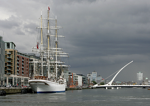
The flotilla are moored two abreast alongside Sir John Rogersons Quay (berth No. 8), which is located on the south quays between the Samuel Beckett and East-Link Bridges. Of the four naval ships, FGS Überherrn is the first to depart on Sunday, the other vessels are to depart on Monday. The vessels will provide an opportunity to view at close quarters a variety of naval architecture design and navies from northern Europe.

Published in Navy
The Naval Service OPV L.E. Roisin (P51) will be open to the public this afternoon (2-4pm) at the North Wall Quay, opposite The National Convention Centre Dublin, which celebrated its first anniversary last month, writes Jehan Ashmore.
L.E. Roisin recently returned from Russia and she berthed for the first time at the North Wall Quay at berth 16A. Normally she would visit Dublin Port by berthing on the south-side banks of the River Liffey along Sir John Rogersons Quay, this applies to other vessel types when mooring within the Dublin 'Docklands'. As such it was most unusual to have a large vessel like L.E Roisin berthing opposite the impressive landmark venue.

It is only in recent years that larger vessels can berth at this stretch of the waterfront following the completion of several major construction projects over the last decade. From the building of the Convention Centre and the Samuel Beckett Bridge which involved using the dredger Hebble Sand (click HERE) during its construction process.

In addition the refurbishment of Spencer Dock sea-lock entrance that for many years was closed is now re-opened. The dock entrance featured in the start of the new television series 'Waterways'-The Royal Canal. Episode two is this Sunday on RTE 1 at 8.30pm.

Aside the 79m L.E. Roisin, the last large vessel to berth close to berth 16A was the French 58m tallship Belem, which was chartered by Alliance Francaise to celebrate their 50th anniversary in 2010 and for the inaugural French Hoist the Sail: Market Festival. The three-masted barque built in 1896 was once also owned by the Sir Arthur Ernest Guinness under the name of Fantôme II.

Situated between where L.E. Roisin is currently berthed and where the Belem had moored, is home to the 'resident' M.V. Cill Airne, a floating bar and restaurant dining venue at berth 16B. Another resident is the former lightship Kittiwake at berth 17B, though sited much further downstream at the end of North Wall Quay, opposite the O2 Arena and next to the East-Link Bridge.

There is a fourth resident, again berthed on the north quays, though the Jeanie Johnston unlike her counterparts is moored closer to the city-centre at Custom House Quay. Apart from yachts, leisure-craft and occasional private motor-yachts using the Dublin City Moorings, she is the only vessel to permanently occupy a berth between Samuel Beckett Bridge and the Sean O'Casey foot-bridge.

Published in Navy

An Taoiseach Enda Kenny visited the Marine Institute's research vessel RV Celtic Explorer in Dublin Port today, where he announced the creation of 92 jobs in the marine sector, writes Jehan Ashmore.

"Ireland is now recognised as an emerging power in Marine Research and Innovation," said the Taoiseach. Of the new positions, 64 will be generated in the seafood processing sector. This follows a €3.5m Seafood Processing Business Investment Scheme administered by Bord Iascaigh Mhara (BIM). In the area of marine research, 28 jobs have been created through funding of €2m from an International SmartOcean Graduate Programme.

SmartOcean is a collaboration between IRCSET (Irish Research Council for Science Engineering and Technology), the Marine Institute, five Irish universities and key multinationals and SME Information and Communication Technology (ICT) companies to provide funding for 28 research posts.

The Taoiseach said: "This has been achieved through the mapping of the 90% of Irish national territory that lies under the Atlantic, the creation of a quarter of a billion Euros worth of marine research infrastructure, and the fostering of strong linkages between industry and research centres, all of which will support employment opportunities in key areas of potential growth in the marine sector."

During the tour of the RV Celtic Explorer, the Taoiseach who was accompanied by Minister for Agriculture, Marine and Food, Simon Coveney, welcomed the expansion of Ireland's capabilities in the international shipping services sector, which is expected to attract additional jobs to the country.

Ireland's emerging international shipping services sector has continued to grow, underpinned by a number of investments in new and second hand ships over the last twelve months by such companies as Arklow Shipping and the Mainport Group, as well as foreign direct investments by D'Amico and Ardmore shipping.

As reported on Afloat.ie, RV Celtic Explorer had arrived yesterday into Dublin Port, having completed a fisheries demersal survey which started in Galway on 23 September. Initially she had docked at Ocean Pier but she subsequently shifted berths to Sir John Rogersons Quay for today's reception of An Taoiseach. According to her survey schedule she is due to depart tomorrow on a herring acoustic survey which is to take place in the Celtic Sea and off the south-west coast.

Published in Marine Science
This is the third 'Arthur's Day', brewed up as a marketers dream to celebrate the world famous black stuff, which was founded over 250 years ago. Though with the passing of generations, how many can still recall their Liffey barges and the final Guinness ships that sailed away in 1993, that of  The Lady Patricia and Miranda Guinness, writes Jehan Ashmore.
They moored at the closest city-centre berth available, on Sir John Rogersons Quay right next to the Matt Talbot Memorial Bridge. The ships sailed to Runcorn (sometimes Salford Docks) on the Manchester Ship Canal. In the past Liverpool was the main terminal for shipping Guinness across the Irish Sea.

The Lady Patricia represented the last of the more traditional Guinness vessels, though her predecessors The Lady Grania and The Lady Gwendolen differred in that they had split superstructures with the bridge admidships and accommodation quarters placed aft. Whereas The Lady Patricia had her superstructure positioned well aft.

In addition she was the last to carry a 'Lady' prefix name. She was named after the daughter of Lord Iveagh, Rupert Guinness, when entering service in 1962 from the yard of Charles Hill & Sons, Bristol. Her entry allowed the Guinness to be eventually replaced when she went to be scrapped at Faslane the following year.

Two deck-mounted granes that were used to hoist silver cylinders containing the beer where removed in 1973 from The Lady Patricia when she was converted into the world's first beer-tanker. The new method no longer required the cumbersome and time-consuming process of loading barrels from trucks. Instead trucks fitted with tanks transferred the liquid-cargo through pipes which involved pumped some 205,000 gallons or 1.87 million pints on board.

Unlike The Lady Patricia which was converted for tanker operations, the Miranda Guinness became the world's first custom-built beer-tanker when launched in 1976 from the Albion Shipyard also in Bristol. She also represented the last vessel to be launched (see PHOTO) there, after 156 years of shipbuilding.

Miranda Guinness was named by the Countess of Iveagh, after whom she was named. The newbuild replaced both The Lady Grania and The Lady Gwendolen which were sold. Since their launch The Lady Patricia and Miranda Guinness were registered in Liverpool until 1987 when the port of registry became Dublin. This arose following a change in the vessels management to Irish Marine Services Ltd, which was made up of former Irish Shipping Ltd management.

This arrangement only lasted to 1993 when Guinness discontinued the world's only beer-tanker shipping operation on the route linking Ireland and Britain. The process had allowed millions of pints to be served through the use of conveying the 'black-stuff' on board the dedicated beer-tankers or should that be those stout ships! Of the two vessels, the Miranda Guinness was the last to depart Dublin Port.

The ships were sold for scrapping on Merseyside and replaced in the form of 20-foot transportable tank trailers towed by trucks using Irish Sea ferry routes. Each of the silver tankers holds 10,000 gallons which is equivilant to 80,000 pints. It would take someone drinking 10 pints a day 22 years to drink it! Now that would be another challenge for the famous Guinness Book of Records!

In addition as we approach 17:59hrs, reflecting the 1759 date of the lease signing by Arthur Guinness, perhaps that minute could also be used to reflect a unique era in Irish brewing transportation methods and shipping history. By the way, Cheers to Arthur!

Published in Ports & Shipping

The arrival of the largest and oldest Norwegian tallship the barque S/S Statsraad Lehmkuhl into Dublin Port yesterday made for an impressive sight, even without her sails set, writes Jehan Ashmore.

At nearly a century-old the square-rigged ship eased her way through the East-Link toll bridge where she proceeded to berth at Sir John Rogersons Quay, where she will be open to the public today between 12:00 – 16:30 and tomorrow,Saturday the 20th August from 10:00 –12:00. Her berth is downriver of the Samuel Beckett swing-bridge and the nearest DART stations are at Grand Canal Dock and Pearse St.
statsraad_1
Statsraad Lehmkuhl is 321-feet long and the barque is also one of the largest three-masted sailing ships in the world. The height from the water-line to the top of the mainmast is 240-feet and in total she carries 22 sails which cover an area of over 2,000 square metres. Under canvass she can achieve 18 knots or when under motor-power her 1,125hp diesel engine manages 11 knots. 
statsraad_2
As reported on Afloat.ie the steel-hulled barque departed her homeport of Bergen last week on a voyage across the North Sea to include a call to Stornoway on the Isle of Lewis. She was built in 1914 originally for the German Merchant Marine and at nearly a century-old she has had a colourful career having changed hands between Germany and Britain during both World Wars.
Since 1978 she has been with her current operators the Statsraad Lehmkuhl Foundation, based in the Nordic's country's second largest city. For further information about the 1,516-tonnes vessel specifications click HERE and interior illustration of deck layout click HERE.
statsraad_3

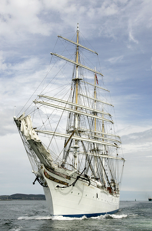
Her arrival marks nearly a year in advance to Dublin City welcoming the return of the Tall Ships Races, presented by Szczecin and organised by Sail Training International. The capital last hosted the event in 1998 and next year up to 100 tall ships are to sail into the capital which will be the final host port for four days between 23rd-26th August 2012.

statsraad_4

Tall Ship S/S Statsraad Lehmkuh in Dublin Bay yesterday. Images: Iain White

The celebration of sail is expected to draw entrants from as far away as Chile, Mexico, Argentina, USA and European and Baltic countries including Italy and Norway will chart their course to Dublin. It is hoped that the event will attract over a million visitors to the city, topping the 500,000 spectators who thronged the Waterford quays during this year's tall ship race gathering.

tallship_jehan

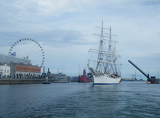
Photo: Jehan Ashmore

Published in Tall Ships
Two vessels from the French Navy based in the Breton naval port of Brest, are to make a four-day visit to Dublin Port during the course of St. Patrick's Day festivities. The minehunter CMT Cassiopée (M642) and mine-route survey craft Altaïr (M771) are to arrive tomorrow morning, writes Jehan Ashmore.
The French vessels are to moor alongside Sir John Rogersons Quay, noting they will not be open to the public. Despite that, the naval ships will be accessible to view at close quarters along the city-centre quayside and the addition of easy road access from the north quays using the nearby Samuel Beckett swing-bridge.

CMT Cassiopée is a 'Tripartite' class minehunter built for the navies of France, Belgium and The Netherlands. The class were conceived in the 1970's and built during the following decade. The French built the mine-hunting equipment, the Belgians provided the electronics and the Dutch constructed the propulsion unit.

Displacing 615 tonnes, Cassiopée (see photo) was built by the Direction des Constructions Navales (DCN) shipyard in Lorient and entered service in 1984. The 51.5m minehunter has a crew of 49. Over the years several of the Tripartite class were sold to the navies of Bulgaria, Indonesia, Latvia and Pakistan.

In January 2009 the Cassiopée was joined by the L.E. Emer (P21) in Bantry Bay to commemmorate the 30th anniversary of the Whiddy Island Oil Refinery disaster and the sinking of the French supertanker the Bételgeuse.

Like the Cassiopée the minehunter BRS Altaïr (M771) was also built in 1984 but at the Chantier (Socarenam) shipyard at Boulogne-sur-Mer. At 28m long the craft (photo) is one of the three Antar class which has a 250 tonnes displacement and a crew of 23.

The French Naval call to the capital was to coincide with a visiting task force group from the German Navy. The task force of two frigates and a support ship were due to visit at the weekend but this was cancelled due to humanitarian relief operations off Libya. To read more about this and the task force vessels click here.

Published in Ports & Shipping

General Information on using Waterways Ireland inland navigations

Safety on the Water

All users of the navigations are strongly recommended to make themselves aware of safety on the water for whatever activity they are involved in and to read the advice offered by the various governing bodies and by:

The Dept. of Transport, Ireland: www.gov.ie/transport and The Maritime and Coastguard Agency, UK, The RNLI – Water Safety Ireland for information in terms of drowning prevention and water safety.

Registration of Vessels

All vessels using the Shannon Navigation, which includes the Shannon-Erne Waterways and the Erne System must be registered with Waterways Ireland. Only open undecked boats with an engine of 15 horsepower or less on the Shannon Navigation, and vessels of 10 horsepower or less on the Erne System, are exempt. Registration is free of charge.

Craft registration should be completed online at: https://www.waterwaysireland.org/online-services/craft-registration

Permits for use of the Grand and Royal Canals and the Barrow Navigation

All vessels using the Grand and Royal Canals and the Barrow Navigation must display appropriate valid Permit(s) i.e A Combined Mooring and Passage Permit (€126) and if not intending to move every five days, an Extended Mooring Permit (€152).

Permit applications should be completed online at: https://www.waterwaysireland.org/online-services/canal-permits

Passage on the Royal and Grand Canals – Dublin Area

For boat passage through the locks east of Lock 12 into / out of Dublin on either the Royal or Grand Canals, Masters are requested to contact the Waterways Ireland Eastern Regional Office (M-F 9.30am-4.30pm) on tel: +353(0)1 868 0148 or email [email protected] prior to making passage in order to plan the necessary lock-keeping assistance arrangements.

On the Grand Canal a minimum of two days notice prior to the planned passage should be given, masters should note that with the exception of pre-arranged events, a maximum of 2 boats per day will be taken through the locks, travelling either east or west.

Movements in or out of the city will be organised by prior arrangement to take place as a single movement in one day. Boaters will be facilitated to travel the system if their passage is considered to be safe by Waterways Ireland and they have the valid permit(s) for mooring and passage.

Newcomen Lifting Bridge

On the Royal Canal two weeks’ notice of bridge passage (Newcomen Lifting Bridge) is required for the pre-set lift date, and lock assistance will then also be arranged. A minimum of 2 boats is required for a bridge lift to go ahead.

Waterways Ireland Eastern Regional Office (Tel: +353(0)1 868 0148 or [email protected] ) is the point of contact for the bridge lift.

A maximum number of boats passing will be implemented to keep to the times given above for the planned lifts (16 for the Sat / Sun lifts & 8 for the weekday lifts). Priority will be given on a first come first served basis.

On day of lift, boaters and passengers must follow guidance from Waterways Ireland staff about sequence of passage under bridge & through Lock 1, and must remain within signed and designated areas.

Events Held on the Waterways

All organised events taking place on the waterways must have the prior approval of Waterways Ireland. This is a twelve week process and application forms must be accompanied with the appropriate insurance, signed indemnity and risk assessment. The application should be completed on the Waterways Ireland events page at :

https://www.waterwaysireland.org/online-services/event-approval

Time Limits on Mooring in Public Harbours

On the Shannon Navigation and the Shannon-Erne Waterway craft may berth in public harbours for five consecutive days or a total of seven days in any one month.

On the Erne System, revised Bye Laws state that: No master or owner shall permit a vessel, boat or any floating or sunken object to remain moored at or in the vicinity of any public mooring, including mooring at any other public mooring within 3 kilometres of that location, for more than 3 consecutive days and shall not moor at that same mooring or any other public mooring within 3 kilometres of that location within the following 3 consecutive days without prior permission by an authorised official.

Winter Mooring on the Shannon Navigation and Shannon Erne Waterway

Winter mooring may be availed of by owners during the period 1 Nov to 31 Mar by prior arrangement and payment of a charge of €63.50 per craft. Craft not availing of Winter Mooring must continue to comply with the “5 Day Rule”. Winter Mooring applications should be completed online at : https://www.waterwaysireland.org/online-services/winter-moorings-booking

Owners should be aware that electricity supply and water supply to public moorings is disconnected for the winter months. This is to protect against frost damage, to reduce running costs and to minimise maintenance requirements during the winter months.

Vessel owners are advised that advance purchasing of electricity on the power bollards leading up to the disconnection date should be minimal. Electricity credit existing on the bollards will not be recoverable after the winter decommissioning date. Both services will be reinstated prior to the commencement of the next boating season.

Smart Cards

Waterways Ireland smart cards are used to operate locks on the Shannon Erne Waterway, to access the service blocks, to use the pump-outs along the navigations, to avail of electrical power at Waterways Ireland jetties.

Berthing in Public Harbours

Masters are reminded of the following:

  • Equip their vessel with mooring lines of appropriate length and strength and only secure their craft to mooring bollards and cleats provided for this purpose.
  • Ensure the available berth is suitable to the length of your vessel, do not overhang the mooring especially on finger moorings on floating pontoon moorings.
  • Ensure mooring lines, electric cables and fresh water hoses do not create a trip hazard on public jetties for others users.
  • Carry sufficient fenders to prevent damage to your own vessel, other vessels and WI property.
  • Allow sufficient space between your vessel and the vessel ahead /astern (c.1m) for fire safety purposes and /or to recover somebody from the water.
  • Do not berth more than two vessels side by side and ensure there is safe access/egress at all times between vessels and onto the harbour itself.
  • Do not berth in such a way to prevent use of harbour safety ladders, slipways or pump-outs.
  • Do not allow the bow of your vessel to overhang the walkway of a floating mooring thus creating a hazard for others with an overhanging anchor or bow fendering.
  • Animals are not allowed to be loose or stray at any time.
  • Harbour and jetty infrastructure such as railings, power pedestals, fresh water taps, electric light poles, safety bollards, ladders etc are not designed for the purpose of mooring craft , they will not bear the strain of a vessel and will be damaged.
  • At Carrybridge on the Erne System, Masters of vessels are not permitted to use stern on mooring. Masters of vessels must use the mooring fingers for mooring of vessels and for embarkation / disembarkation from vessels.

Passenger Vessel Berths

Masters of vessels should not berth on passenger vessel berths where it is indicated that an arrival is imminent. Passenger vessels plying the navigations generally only occupy the berths to embark and disembark passengers and rarely remain on the berths for extended periods or overnight.

Lock Lead-in Jetties

Lead-in jetties adjacent to the upstream and downstream gates at lock chambers are solely for the purpose of craft waiting to use the lock and should not be used for long term berthing.

Vessel Wake

Vessel wake, that is, the wave generated by the passage of the boat through the water, can sometimes be large, powerful and destructive depending on the hull shape and engine power of the vessel. This wake can be detrimental to other users of the navigation when it strikes their craft or inundates the shoreline or riverbank. Masters are requested to frequently look behind and check the effect of their wake / wash particularly when passing moored vessels, on entering harbours and approaching jetties and to be aware of people pursuing other activities such as fishing on the riverbank.

Speed Restriction

A vessel or boat shall not be navigated on the Shannon Navigation at a speed in excess of 5 kph when within 200 metres of a bridge, quay, jetty or wharf, when in a harbour or canal or when passing within 100 metres of a moored vessel or boat.

Vessels navigating the Shannon-Erne Waterway should observe the general 5 kph speed limit which applies along the waterway. This is necessary in order to prevent damage to the banks caused by excessive wash from vessels.

Vessels navigating the Erne System should observe the statutory 5kt / 6mph / 10kph speed limit areas.

A craft on the Royal and Grand canals shall not be navigated at a speed in excess of 6km per hour.

A craft on the Barrow Navigation shall not be navigated at a speed in excess of 11km per hour except as necessary for safe navigation in conditions of fast flow.

Bank Erosion

Narrow sections of all the navigations are particularly prone to bank erosion due to the large wash generated by some craft. Masters are requested to be vigilant and to slow down to a speed sufficient to maintain steerage when they observe the wash of their craft inundating the river banks.

Unusual Waterborne Activity

Unusual waterborne vessels may be encountered from time to time, such as, hovercraft or amphibious aircraft / seaplanes. Masters of such craft are reminded to apply the normal “Rule of the Road” when they meet conventional craft on the water and to allow extra room to manoeuvre in the interest of safety.

Sailing Activity

Mariners will encounter large numbers of sailing dinghies from late June to August in the vicinity of Lough Derg, Lough Ree and Lower Lough Erne. Sailing courses are marked by yellow buoys to suit weather conditions on the day. Vessels should proceed at slow speed and with due caution and observe the rules of navigation when passing these fleets, as many of the participants are junior sailors under training.

Rowing

Mariners should expect to meet canoes and vessels under oars on any part of the navigations, but more so in the vicinity of Athlone, Carrick-on-Shannon, Coleraine, Enniskillen and Limerick. Masters are reminded to proceed at slow speed and especially to reduce their wash to a minimum when passing these craft as they can be easily upset and swamped due to their very low freeboard and always be prepared to give way in any given traffic situation.

Canoeing

Canoeing is an adventure sport and participants are strongly recommended to seek the advice of the sport’s governing bodies i.e Canoeing Ireland and the Canoe Association of Northern Ireland, before venturing onto the navigations.

Persons in charge of canoes are reminded of the inherent danger to these craft associated with operating close to weirs, sluice gates, locks and other infrastructure particularly when rivers are in flood and large volumes of water are moving through the navigations due to general flood conditions or very heavy localised precipitation e.g. turbulent and broken water, stopper waves. Shooting weirs is prohibited without prior permission of Waterways Ireland.

Canoeists should check with lockkeepers prior entering a lock to ensure passage is done in a safe manner. Portage is required at all unmanned locks.

Canoe Trail Network – "Blueways"

Masters of powered craft are reminded that a canoe trail network is being developed across all navigations and to expect more organised canoeing along these trails necessitating slow speed and minimum wash when encountering canoeists, rowing boats etc

Rockingham and Drummans Island Canals – Lough Key

It is expected that work on Rockingham and Drummans Island Canals on Lough Key will be completed in 2021. Access to these canals will be for non-powered craft only, eg canoes, kayaks, rowing boats.

Fast Powerboats and Personal Watercraft (Jet Skis)

Masters of Fast Powerboats (speed greater than 17kts) and Personal Watercraft (i.e.Jet Skis) are reminded of the inherent dangers associated with high speed on the water and especially in the confines of small bays and narrow sections of the navigations. Keeping a proper look-out, making early alterations to course and /or reducing speed will avoid conflict with slower vessels using the navigation. Personal Watercraft are not permitted to be used on the canals.

Towing Waterskiers, Wakeboarders, Doughnuts etc

Masters of vessels engaged in any of these activities are reminded of the manoeuvring constraints imposed upon their vessel by the tow and of the added responsibilities that they have to the person(s) being towed. These activities should be conducted in areas which are clear of conflicting traffic. It is highly recommended that a person additional to the master be carried to act as a “look-out” to keep the tow under observation at all times.

Prohibition on Swimming

Swimming in the navigable channel, particularly at bridges, is dangerous and is prohibited due to the risk of being run over by a vessel underway in the navigation.

Age Restrictions on operating of powered craft

In the Republic of Ireland, Statutory Instrument 921 of 2005 provides the legal requirements regarding the minimum age for operating of powered craft. The Statutory Instrument contains the following requirements:

- The master or owner of a personal watercraft or a fast power craft shall take all reasonable steps to ensure that a person who has not attained the age of 16 years does not operate or control the craft

- The master or owner of a pleasure craft powered by an engine with a rating of more than 5 horse power or 3.7 kilowatts shall take all reasonable steps to ensure that a person who has not attained the age of 12 years does not operate or control the craft.

Lifejackets and Personal Flotation Devices (PFDs)

Lifejackets and PFD’s are the single most important items of personal protective equipment to be used on a vessel and should be worn especially when the vessel is being manoeuvred such as entering / departing a lock, anchoring, coming alongside or departing a jetty or quayside.

In the Republic of Ireland, Statutory Instrument 921 of 2005 provides the legal requirements regarding the wearing of Personal Flotation Devices. The Statutory Instrument contains the following requirements:

- The master or owner of a pleasure craft (other than a personal watercraft) shall ensure, that there are, at all times on board the craft, sufficient suitable personal flotation devices for each person on board.

- A person on a pleasure craft (other than a personal watercraft) of less than 7 metres length overall shall wear a suitable personal flotation device while on board an open craft or while on the deck of decked craft, other than when the craft is made fast to the shore or at anchor.

- The master or owner of a pleasure craft (other than a personal watercraft) shall take all reasonable steps to ensure that a person who has not attained the age of 16 years complies with paragraph above.

- The master or owner of a pleasure craft (other than a personal watercraft), shall take all reasonable steps to ensure that a person who has not attained the age of 16 years wears a suitable personal flotation device while on board an open craft or while on the deck of a decked craft other than when it is made fast to the shore or at anchor.

- The master or owner of a pleasure craft (other than a personal watercraft) shall take all reasonable steps to ensure that a person wears a suitable personal flotation device, at all times while – (a) being towed by the craft, (b) on board a vessel or object of any kind which is being towed by the craft.

Further information is available at: http://www.irishstatutebook.ie/eli/2005/si/921/made/en/print

Firing Range Danger Area – Lough Ree

The attention of mariners is drawn to the Irish Defence Forces Firing Range situated in the vicinity of buoys No’s 2 and 3, on Lough Ree on the Shannon Navigation. This range is used regularly for live firing exercises, throughout the year, all boats and vessels should stay clear of the area marked with yellow buoys showing a yellow "X" topmark and displaying the word "Danger".

Shannon Navigation, Portumna Swing Bridge Tolls

No attempt should be made by Masters’ of vessels to pay the bridge toll while making way through the bridge opening. Payment will only be taken by the Collector from Masters when they are secured alongside the jetties north and south of the bridge.

Navigating from Killaloe to Limerick on the Shannon Navigation

The navigation from Killaloe to Limerick involves passage through Ardnacrusha locks, the associated headrace and tailrace and the Abbey River into Limerick City. Careful passage planning is required to undertake this voyage. Considerations include: lock passage at Ardnacrusha, water flow in the navigation, airdraft under bridges on Abbey River in Limerick, state of tide in Limerick

Users are advised to contact the ESB Ardnacrusha hydroelectric power station (00353 (0)87 9970131) 48 hours in advance of commencing their journey to book passage through the locks at Ardnacrusha. It is NOT advised to undertake a voyage if more than one turbine is operating (20MW), due to the increased velocity of flow in the navigation channel, which can be dangerous. To ascertain automatically in real time how many turbines are running, users can phone +353 (0)87 6477229.

For safety reasons the ESB has advised that only powered craft with a capacity in excess of 5 knots are allowed to enter Ardnacrusha Headrace and Tailrace Canals.

Passage through Sarsfield Lock should be booked on +353-87-7972998, on the day prior to travel and it should be noted also that transit is not possible two hours either side of low water.

A Hydrographic survey in 2020 of the navigation channel revealed that the approach from Shannon Bridge to Sarsfield Lock and the Dock area has silted up. Masters of vessels and water users are advised to navigate to the Lock from Shannon bridge on a rising tide one or two hours before High Tide.

Lower Bann Navigation

The attention of all users is drawn to the “Users Code for the Lower Bann”, in particular to that section covering “Flow in the River” outlining the dangers for users both on the banks and in the navigation, associated with high flow rates when the river is in spate. Canoeists should consult and carry a copy of the “Lower Bann Canoe Trail” guide issued by the Canoe Association of Northern Ireland. Users should also contact the DfI Rivers Coleraine, who is responsible for regulating the flow rates on the river, for advisory information on the flow rates to be expected on any given day.

DfI Rivers Coleraine. Tel: 0044 28 7034 2357 Email: [email protected]

Lower Bann Navigation – Newferry – No wake zone

A No Wake Zone exists on the Lower Bann Navigation at Newferry. Masters of vessels are requested to proceed at a slow speed and create no wake while passing the jetties and slipways at Newferry.

Overhead Power Lines (OHPL) and Air draft

All Masters must be aware of the dangers associated with overhead power lines, in particular sailing vessels and workboats with cranes or large air drafts. Voyage planning is a necessity in order to identify the location of overhead lines crossing the navigation.

Overhead power line heights on the River Shannon are maintained at 12.6metres (40 feet) from Normal Summer level for that section of navigation, masters of vessels with a large air draft should proceed with caution and make additional allowances when water levels are high.

If a vessel or its equipment comes into contact with an OHPL the operator should NOT attempt to move the vessel or equipment. The conductor may still be alive or re-energise automatically. Maintain a safe distance and prevent third parties from approaching due to risk of arcing. Contact the emergency services for assistance.

Anglers are also reminded that a minimum ground distance of 30 metres should be maintained from overhead power lines when using a rod and line.

Submarine Cables and Pipes

Masters of vessels are reminded not to anchor their vessels in the vicinity of submarine cables or pipes in case they foul their anchor or damage the cables or pipes. Look to the river banks for signage indicating their presence.

Water Levels - Precautions

Low Water Levels:

When water levels fall below normal summer levels masters should be aware of:

Navigation

To reduce the risk of grounding masters should navigate on or near the centreline of the channel, avoid short cutting in dog-legged channels and navigating too close to navigation markers.

Proceeding at a slow speed will also reduce “squat” effect i.e. where the vessel tends to sit lower in the water as a consequence of higher speed.

Slipways

Reduced slipway length available under the water surface and the possibility of launching trailers dropping off the end of the concrete apron.

More slipway surface susceptible to weed growth requiring care while engaged in launching boats, from slipping and sliding on the slope. Note also that launching vehicles may not be able to get sufficient traction on the slipway once the craft is launched to get up the incline.

Bank Erosion

Very dry riverbanks are more susceptible to erosion from vessel wash.

Lock Share

Maximising on the number of vessels in a lock will ensure that the total volume of water moving downstream is decreased. Lock cycles should be used for vessels travelling each way.

High Water Levels:

When water levels rise above normal summer level masters should be aware of:

Navigation

Navigation marks will have reduced height above the water level or may disappear underwater altogether making the navigable channel difficult to discern.

In narrow sections of the navigations water levels will tend to rise more quickly than in main streams and air draft at bridges will likewise be reduced.

There will also be increased flow rates particularly in the vicinity of navigation infrastructure such as bridges, weirs, locks etc where extra care in manoeuvring vessels will be required.

Harbours and Jetties

Due care is required in harbours and at slipways when levels are at or near the same level as the harbour walkways' as the edge will be difficult to discern especially in reduced light conditions. It is advised that Personal Flotation Devices be worn if tending to craft in a harbour in these conditions.

Slipways

Slipways should only be used for the purpose of launching and recovering of water craft or other objects from the water. Before using a slipway it should be examined to ensure that the surface has sufficient traction/grip for the intended purpose such as launching a craft from a trailer using a vehicle, that there is sufficient depth of water on the slipway to float the craft off the trailer before the concrete apron ends and that the wheels of the trailer do not drop off the edge of the slipway. That life-saving appliances are available in the vicinity, that the vehicle is roadworthy and capable of coping with the weight of the trailer and boat on the incline. It is recommended that slipway operations are conducted by two persons.

Caution to be Used in Reliance upon Aids to Navigation

The aids to navigation depicted on the navigation guides comprise a system of fixed and floating aids to navigation. Prudent mariners will not rely solely on any single aid to navigation, particularly a floating aid to navigation. With respect to buoys, the buoy symbol is used to indicate the approximate position of the buoy body and the ground tackle which secures it to the lake or river bed. The approximate position is used because of the practical limitations in positioning and maintaining buoys in precise geographical locations. These limitations include, but are not limited to, prevailing atmospheric and lake/river conditions, the slope of and the material making up the lake/river bed, the fact that the buoys are moored to varying lengths of chain, and the fact that the buoy body and/or ground tackle positions are not under continuous surveillance. Due to the forces of nature, the position of the buoy body can be expected to shift inside and outside the charted symbol.

Buoys and perches are also moved out of position or pulled over by those mariners who use them to moor up to instead of anchoring. To this end, mariners should always monitor their passage by relating buoy/perch positions with the published navigation guide. Furthermore, a vessel attempting to pass close by always risks collision with a yawing buoy or with the obstruction that the buoy or beacon/perch marks.

Masters of Vessels are requested to use the most up to date Navigation guides when navigating on the Inland Waterways.

Information taken from Special Marine Notice No 1 of 2023