


Displaying items by tag: Newfoundland
Mini Boat Which Crossed Atlantic to Achill from Newfoundland Due to Be Launched Again
A mini boat that was swept from Newfoundland’s Grand Banks to Achill Island in Storm Erik is due to be relaunched off Ireland sometime in the next few weeks.
The Newfoundland students who first helped to launch the 1.8m (6ft) Raven Kaster are working with Achill island pupils on preparing it for another sea voyage.
This time, it will also collect ocean climate data and may end up off the Iberian coast or up in Scandinavia, depending on where it is launched.
“The way ocean currents work, we don’t know where it will land, and a lot depends on where we launch it again,” Thomas Sheppard, a teacher at Frank Roberts Junior High in Newfoundland, explained.
“The only way it would return to North America is if it is launched off the coast of Africa,” he said.
Canadian students Stephanie Evans and Kaitlyn Grandy, who led the project back in 2018 while at school, recalled that they weren’t sure if they would ever see their little craft again when they were reunited with it for the first time this past weekend in Galway.
“We had the GPS track on it after it was launched by a Maersk ship for us on the Grand Banks in November 2018, and it looked like it was going to bypass Ireland and head south,” Evans recalled.
“Then we saw it heading for a little island off Ireland, and we just hoped there were people there! “ she said.
Raven Kaster, as the craft is named, was washed up on Dookinella Beach on Achill Island after 102 days at sea, and was found there in February 2019 by local fisherman Darren Kilbane.
Evans and Grandy have travelled to Ireland with Sheppard, their teacher, to meet pupils at Coláiste Pobail Acla secondary school and their deputy principal, Karen Lavelle, who are working on the re-launch project.
One of their first stops was at Galway Atlantaquaria in Salthill to view the Raven Kaster. They will also discuss the re-launch logistics with the Marine Institute in Galway this coming week.
Neither Evans nor Grandy had heard of Achill Island when the GPS track indicated it had landed there.
The 1.8m (six ft) boat was purchased through Educational Passages, a non-profit company that runs a mini boat programme.
“Most of them are GPS based, with solar power for the GPS and sail, along with a cargo hold for notes which the students can leave inside,” Sheppard explained.
“Now it is going to be fitted with software which will allow for measuring air temperature, water temperature, orientation, and it will have a camera – stuff we didn’t have available to us when we launched the boat back in 2018,” Sheppard said.
“It wasn’t in bad condition when Darren Kilbane found it, and his daughter Ria is one of the transition year students who has been working on it,” Lavelle explained.
“We hope the Marine Institute’s research ship Celtic Voyager will take it out to the Porcupine before the winter storm season. Depending on the weather and ocean currents, it could go up or down the Atlantic,” she said.
Why Do We Irish Not Take More Pride in What We Are?
I have spent many years trying to create more interest in the maritime sphere. Sometimes it can be frustrating and disappointing to see the continued level of disinterest, particularly amongst our political fraternity, most of whom seem to have little or no pride in being islanders. That is what they and we all are, the people of an island nation.
Why, I wonder, do we have to be told as a people that we must become ‘more European,’ so that we ape the characteristics and the lifestyles of those who live on the European mainland? As a people is our own history, culture, not more important? Do our characteristics not define us as a people?
In this week’s edition of THIS ISLAND NATION radio programme, these are points I raise following a visit to another island nation with a great Irish tradition – Newfoundland. They are a people who know where they came from, who take pride in their history. Their nation is redolent of the maritime sphere, the marine aspect is everywhere in their culture and they take pride in it, as well as being Irish descendants.
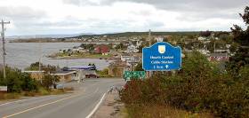
The Irish presence is dominant in the Irish Loop on the Avalon Peninsula, along the southern and western shores and up the Bonavista Peninsula in the north, where I travelled. Fishing communities were devastated by the collapse of the cod fishery in the 90s, though it is showing signs of recovery. One place I particularly wanted to see was Heart’s Content, linked in history with Valentia Island in Kerry where both communities, thousands of miles apart across the Atlantic Ocean, are this year marking the 150th anniversary of the completion of the TransAtlantic Cable which opened the world of communications between Europe and America. I reported the celebrations at Valentia in July where the community is trying to get the island declared a UNESCO Heritage Site. At Heart’s Content, a remote community in the north of the Avalon Peninsula, the cable station is preserved in its original state and is a big visitor attraction. The lesson from Heart’s Content is the importance of preserving artefacts. Too often in Ireland the rush to be modern has led to the casting away of aspects of our culture, tradition and history.
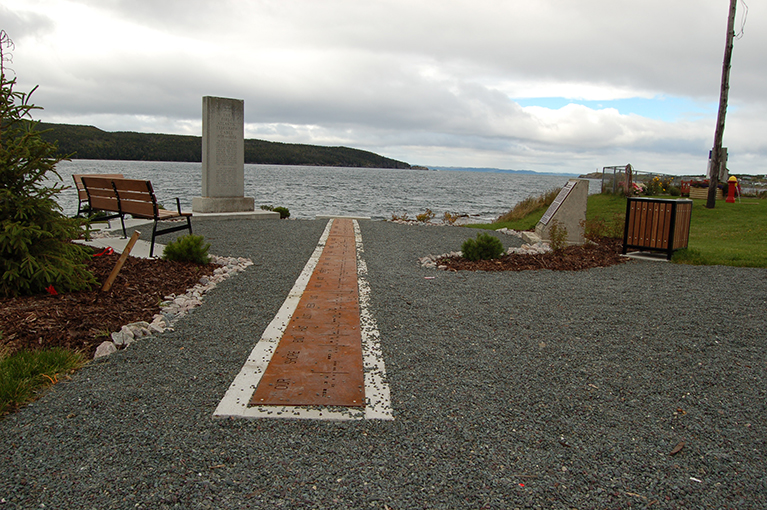 The location where transatlantic cable was brought ashore from Valentia at Heart's Content in Newfoundland in 1866
• Listen to the programme below as Linda Sooley, Historic Site Supervisor for the Newfoundland and Labrador Government outlines the benefits which preserving history has brought to the community of Heart’s Content.
Trans-Atlantic Mapping Survey Launched
#survey – Today, a multi-national team of European, Canadian, and American ocean mapping experts launch the first trans-Atlantic mapping survey under the Atlantic Ocean Research Alliance.
The survey is one of the first projects to be launched by the Alliance, formed in May 2013 following the Galway Statement on Atlantic Ocean Cooperation, whose goals are to join resources of its three signatories to better understand the North Atlantic Ocean and to promote the sustainable management of its resources.
Under this new era of cooperation on ocean research, Canada's Fisheries and Marine Institute of Memorial University of Newfoundland will use the Irish research vessel, RV Celtic Explorer, to map the seafloor between St. John's, Newfoundland and Labrador, Canada and Galway, Ireland.
The Government of Newfoundland and Labrador has invested approximately $5 million in RV Celtic Explorer expeditions since 2010 to support fisheries science activities. The vessel has just completed this year's fisheries survey and is returning to Ireland providing the additional opportunity for this trans-Atlantic mapping survey.
Together, with scientists from Ireland's national seabed mapping programme, INFOMAR, at the Marine Institute and Geological Survey of Ireland, and the United States' National Oceanic and Atmospheric Administration (NOAA), and the Portuguese Institute for Sea and Atmosphere (IPMA), the team will use multi-beam echo sounders onboard the vessel to collect ocean mapping data during the transect.
The team will gather information on the physical characteristics of the seafloor, such as water depth, hardness, roughness, and the presence of geohazards. The structure and composition of the near subsurface are key considerations for shipping safety, development-related seabed engineering and sustainable fisheries. The survey will broadly follow the great circle route between Ireland and Newfoundland where the first trans-Atlantic cable was deployed in 1857. The team hopes to map the location where the cable was dropped in the mid-Atlantic, which happened to coincide with the most dramatic topographic feature in the North Atlantic, the Charlie Gibbs Fracture Zone.
"The North Atlantic Ocean is crucial to the ecological, economic, and societal health and resilience of North America, Europe and the Arctic regions and the data we collect will be vital to understanding how we move forward together to ensure its sustainability," said Glenn Blackwood, vice-president, Memorial University (Marine Institute). "We are pleased to lend our ocean mapping expertise in this field and contribute in such a meaningful way for our shared benefit."
"We are happy to see Canadian federal, provincial and academic participation in the Atlantic Ocean Research Alliance," said the Honourable Gail Shea, Canada's Minister of Fisheries and Oceans. "The contribution of so many Canadian scientific experts in this important international initiative demonstrates Canada's commitment to the Atlantic Ocean and the Galway Agreement."
"We are proud to be part of the first trilateral expedition under the Atlantic Ocean Research Alliance," said Kathryn Sullivan, U.S. Undersecretary of Commerce for Oceans and Atmosphere and NOAA administrator. "By collaborating fully within this agreement, we will contribute essential scientific knowledge and ensure our shared Atlantic Ocean remains healthy and productive."
"This is an exciting opportunity to identify some important sites on the Atlantic seabed. It marks the beginning of an Atlantic research mapping collaboration between the US, Canada and Europe. We hope to build on next year in 2016 and subsequent years when Ireland's RV Celtic Explorer will be joined by research vessels from Norway and the USA", said Dr. Peter Heffernan, Marine Institute, Ireland.
Speaking at the announcement of the survey in Brussels in April 2015, Simon Coveney, Irish Minister for Agriculture Food and the Marine, said, "Information from the sea-floor is vital to the sustainable management of the Atlantic as well as to important industries such as fisheries, aquaculture and tourism. Ireland has developed a world-leading reputation for sea-bed mapping and is also very committed to the implementation of the Galway Statement and so I am delighted Ireland's state-of the art research vessel-RV Celtic Explorer is the platform for the survey."
"The collaborative mapping of the Atlantic Ocean by Canada, the US and Europe is an important initiative which, as a provincial government, we are proud to support," said the Honourable Darin King, Minister of Business, Tourism, Culture and Rural Development. "This tangible initiative builds on the work my department has been undertaking to facilitate partnerships and economic opportunities between Newfoundland and Labrador and Ireland and on a broader scale between Canada, the US and Europe."
Planning for the survey began in December 2014 when the first seabed mapping event took place in Dublin, Ireland followed by a second meeting in February 2015 in Brussels, Belgium.
Catching Your Dinner Off the West Coast
Deep sea fishing is alive and well off the west coast of Ireland, and not only is it a hugely enjoyable sport - just one catch can be enough to feed the whole family.
That's what The Irish Times' Elizabeth Birdthistle discovered in the last of her series on catching your dinner in Ireland.
Birdthistle set out for the waters off Inis Boffin with John Brittain, who has been skippering his angling boat Bluewater for 20 years for the charter fishing season between April and October.
The boat takes up to 12 anglers who are more than eager to pay €70 a head to catch large cod, pollack and mackerel in abundance. Even novices are welcome, as the fee covers all rods, tackle and tuition.
Squid and octopus are also on the cards, as are some larger quarries such as sharks and ray - though these can only be fished in a tag-and-release programme. Smaller catches also get thrown back to propogate.
"The biggest shark caught here weighed 150lbs," writes Birdthistle, "and, as with all sharks caught, Brittain must tread with caution to release the giant hook or else the shark returns to the deep with part of his hand.
"The tagged sharks have been caught as far away as the Grand Banks off Newfoundland and the Cape Verde islands."
The Irish Times has more on the story HERE.
Rower Calls a Halt to Atlantic Crossing
An Irish rower last week cut short his attempt to cross the Atlantic from Newfoundland to Ireland.
Sean Moriarty told CBC News that he called for a rescue after two days at sea when his boat was flipped repeatedly in four-metre waves, damaging his electronic equipment.
Moriarty and his boat - the unfortunately named Positive Outcome - were picked up by a Canadian coastguard vessel and towed to St John's in Newfoundland on 13 June.
The Dingle native, who runs a construction firm, plans to ship his boat back home to Ireland.
Tripartite Naval Visitors for Dublin Port
Naval vessels from France, Canada and Belgium are due to make calls to Dublin Port over the weekend, writes Jehan Ashmore.
The first visitor to dock tomorrow will be the Latouche-Tréville (D646) a F70 type anti-submarine frigate of the French Marine Nationale. She is one of seven F70 ASM class anti-submarine frigates and is capable of carrying two 2 Lynx helicopters. In June 2010 the frigate visited London where the 1984 built 3,550 tonnes vessel moored alongside the WW II cruiser, HMS Belfast.
Also due to arrive tomorrow is the Canadian Navy's HMCS St. John's which too is to berth at Ocean Pier. HMCS St. John's (340) is the eleventh 'Halifax' class frigate, measuring some 4,770 tonnes. The multi-role patrol frigate was commissioned in 1996 in St. John's, Newfoundland and is designed to perform three distinct functions: anti-submarine warfare, anti-air warfare and anti-surface warfare.
On Sunday the third international naval visitor to Dublin Port will be the Belgium Navy's Léopold I (F930). This frigate is based in the Quartier Naval Base in Zeebrugge and in 1997 she was commissioned into service in a ceremony by Belgium's Queen Fabiola.
The 2,800 tonnes frigate is capable of taking two helicopters and the vessel can cruise at 21 knots using two diesel engines or is capable of reaching a top speed of 30 knots based from gas turbine power-plants. Léopold I has participated in NATO's Response Force (NRF). For a detailed visual discription of equipment click this link here
'The Sea: One of Ireland's Greatest Natural Resources' - Coveney

The Minister was speaking during a visit to the Marine Institute's research vessel, RV Celtic Explorer, on its return from a mission to the Labrador and Newfoundland Seas.
He added "I am particularly pleased that this is my first official engagement as Minister for Agriculture, Marine and Food. The work of the RV Celtic Explorer highlights the essential nature of marine research, development and sustainable management, through which Ireland is developing a strong and well-deserved reputation as an emerging centre of excellence, where we have prominent roles in many European and international marine science bodies."
Minister Coveney commended the Marine Institute and its Chief Executive, Dr Peter Heffernan, for its leading and proactive role in the areas of fisheries science, marine environment and food safety as well as ocean science and said that he looked forward to working closely with the Institute and benefitting from the research and advice which they would undertake and provide.
The Minister noted that Ireland's two national research vessels – RV Celtic Explorer and RV Celtic Voyager – will record 267 days at sea during 2011, during which they will be engaged in fisheries surveys, underwater mapping, climate studies and deepwater surveys.

Seeing the capabilities of Ireland's largest research vessel and the work of the Marine Institute, Mr Simon Coveney highlighted the importance the Marine Sector has on the Irish economy. "The seas and ocean that surround the land of Ireland is arguably one of our countries greatest natural resources. Through marine research, development and sustainable management, Ireland is developing a strong reputation as an emerging centre of excellence, where we have prominent roles in many European and international marine science bodies," he said.
Ireland's national research vessels RV Celtic Explorer and RV Celtic Voyager will record 627 days at sea between the two during 2011. Their work will range from fisheries surveys to underwater mapping and from climate studies to deepwater surveys with the remotely operated submersible ROV Holland 1.
"The work conducted on the vessels continues to feed into the success in attracting EU funding to Ireland's marine science programmes that have been achieved by our strategic approach to marine science planning" explained Dr Peter Heffernan, CEO of the Marine Institute.
"The award of funding projects shows that partnerships between academics and small businesses can yield significant dividends in creating jobs, generating economic revenue and the supply of raw materials for new industries ranging from ocean energy and environmental monitoring technologies to marine-inspired pharmaceuticals and food ingredients" he further said.
Historic Trophy for South Pacific Dream Cruise
Fergus and Kay Quinlan live in the Burren in County Clare, and in 1997 they launched the steel van de Stadt 12-metre cruiser Pylades, which they'd built themselves. They've made several voyages and have been in the Irish Cruising Club's award list before. But at the ICC's AGM in the National YC on February 18th they deservedly got the big one, the Faulkner Cup, for the first stage of a global circumnavigation which began from their home port of Kinvara in the summer of 2009, and a year later they'd reached Tahiti.
Their cruise continues, so the award was made in absentia. Adjudicator Brian Cudmore of Cork made the point that their informative log included much general and often entertaining information, and it becomes even more interesting the further you got into it, so he's keenly anticipating the next inmstalment.
The Strangford Cup for an alternative best cruise could not have been more different, both in location or boat type. The 44ft Young Larry may have been built of steel in 1995, but she was based fairly precisely on the design of a gaff cutter built in 1907. And though the rig has been made more manageable through being a yawl, even the mizzen is gaff-headed, while the main sets a topsail. Not the most-easily handled rig for challenging seas, you might well think, but Maire Breathnach (originally from Dungarvan) and her partner Andrew Wilkes, crewed by Maire's niece Sibeal Turraoin, took Larry Og – which looks for all the world like a smaller Asgard I – right through the Northwest Passage to Alaska, an extraordinary one-season achievement.
The ICC members logged some other notable Atlantic voyages, with Michael Coleman of Cobh, a Port of Cork Pilot before he got the free bus pass, making a fine Atlantic triangle to the Azores, then Newfoundland, and so home to Cork, visiting many islands with his well-found 1988 Oyster 53 Oyster Cove. It was all done with a crew of average age 66, senior member Tom Noonan aged 76, and worthy winners of the Atlantic Trophy.
Over the years since its foundation in 1929, the Irish Cruising Club has become the trustee and adjudicator of many trophies, twenty in all, and two of them were special presentations in 2010. The Donegan Memorial Trophy went to Ruth Heard, an ICC member since 1967. She has cruised both to the Azores and Iceland, but is honoured this year in celebration of her remarkable contribution to the rebirth of the inland waterways, and to mark the re-opening of the Royal Canal. Ruth Heard was on the crew of Harklow, the last boat to transit the Royal in 1954 before its half century of official closure which was gloriously reversed in 2010.
And once upon a time, the ICC was the organiser of Ireland's Admiral's Cup campaigns. Though many members still race offshore as individuals, the club has long since focused totally on cruising. But it has a general trophy, the John B Kearney Cup for Services to Irish Sailing, and for 2010 it was awarded with acclamation to the successful Irish Commodore's Cup Team.
- Faulkner
- Cruise
- Cruising
- Cup
- Club
- Quinlan
- Kay
- Fergus
- ICC
- National
- yacht
- cub
- YC
- Cudmore
- Cork
- Breathnach
- Alaska
- Asgard I
- Strangford
- Burren
- Pylades
- Northwest
- Passage
- Wilkes
- Sibeal Turraoin
- Coleman
- Atlantic
- Cobh
- Newfoundland
- Oyster Cove
- Oyster
- Donegan
- trophy
- Ruth Heard
- John B Kearney
- Cup
- Commodore's
- gaff

Minister Smith said "I am delighted to sign today a new Accord on Marine Research between Newfoundland and Labrador and the Irish Authorities. The initiative involves a partnership approach between the Fisheries and Marine Institute of Memorial University of Newfoundland and Ireland's Marine Institute including the charter of the state-of-the-art research vessel 'Celtic Explorer'. Both Institutes have strong capabilities in ocean technology and research. Through this alliance, there is now an opportunity to bring the strengths of both Institutes to greater levels".
Minister of State Connick added that "The proposed EU Atlantic Strategy under the EU Integrated Maritime Policy and the support for a Joint Programming Initiative on Healthy Seas & Oceans recently announced by Ms. Máire Geoghegan-Quinn the European Commissioner for Research, Innovation and Science, highlight the increasing importance of linking the scientific challenges on both sides of the Atlantic."
Welcoming the chartering of the RV Celtic Explorer, Mr Clyde Jackman, Minister for Fisheries and Aquaculture – Newfoundland said "It will enable our academic institutions to take their already world class research to the next level and support a state of the art fishing industry that is based on better science. This initiative will create many new opportunities for young Newfoundlanders and Labradorians, as a result of a more vibrant fishing industry and in conducting fisheries science research".
"Thanks to the support of our Provincial Government, the Marine Institute of Memorial University of Newfoundland is further positioned to play a vital role in the future of fisheries in Newfoundland and Labrador. With the chartering the RV Celtic Explorer and the creation of our new Centre for Fisheries Ecosystem Research the Marine Institute is further positioned to play a vital role in fisheries science research in our province," said Glenn Blackwood, the Executive Director of the Fisheries and Marine Institute of Memorial University of Newfoundland.
"Research lead by personnel from the Centre for Fisheries Ecosystem Research and conducted aboard the RV Celtic Explorer will help develop a better understanding of the state of Newfoundland and Labrador's fish stocks and the dynamics of its marine ecosystems, providing new information to support better decisions." he said.
"The strong alliance the Marine Institute, Ireland has with the Fisheries and Marine Institute of Memorial University of Newfoundland will enable transatlantic collaboration to support the rapidly expanding fisheries research programmes in Newfoundland waters" said Dr Peter Heffernan, CEO of the Marine Institute.
"We are delighted with this opportunity to work with such a prominent team of fisheries scientists and we look forward to exploring with our Newfoundland colleagues how we can also build stronger links as part of a wider international ocean observation initiative to study the Gulf Stream and North Atlantic Drift. This could link SMART technology to monitor climate change and environmental conditions in both Irish and Newfoundland waters and stimulate commercial spin off opportunities."
"Projects linking technologies, equipment and expertise on both sides of the Atlantic would therefore enhance Ireland and Newfoundland's capability to perform in the forefront of scientific endeavours as our strategic geographic location demands," he further added.
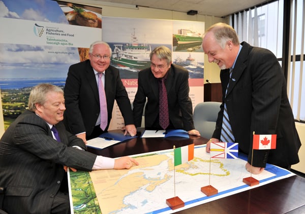
Brendan Smith TD, Minister for Agriculture, Fisheries and Food and Sean Connick TD, Minister of State at the Department of Agriculture, Fisheries and Food signing an accord with their Newfoundland counterparts Minister Clyde Jackman and Deputy Minister Alastair O’Reilly In Agriculture House.


 as lead helm, rounds the Fastnet Rock on the way to the overall win in 1987")
