Menu

Ireland's sailing, boating & maritime magazine

Inland afloat headers


Displaying items by tag: Marine Institute

Clew Bay and Achill, Co Mayo will be among the key study areas in SeaMonitor, a unique marine research project which is using innovative marine species tracking technology to better understand and protect vulnerable marine life in our oceans. The project is funded by EU INTERREG VA Programme and led by the Loughs Agency and supported by another eight leading marine research institutions, including the Marine Institute.

The innovative technology, called passive acoustic telemetry, relies on underwater tracking stations (acoustic receivers) to monitor the movements of marine animals tagged with acoustic transmitters. This technology will be used to better understand the movement and behaviour of species such as seals, basking shark, skate, cetaceans and salmon.

This new technology will be utilised in Clew Bay and Achill, to enable the Marine Institute to monitor juvenile salmon smolts as they make their first journey past Clare Island and on to the Atlantic Ocean. Acoustic receivers will be placed in strategic positions on what has been identified as the salmon “highway” through Clew Bay. This research will build on previous studies in the area, which indicate a high survival rate of salmon smolts through the Inner Bay and to Clare Island. Studies have also indicated that smolts following ocean currents seem to travel the northern route past Clare Island.

Clare Island, Co MayoClare Island, Co Mayo Photo by Catherine Waters/Marine Institute

As part of the SeaMonitor project, the Marine Institute will be tagging smolts from the Burrishoole catchment over the next two years. Their journey will be monitored through Clew Bay and Achill, onward along the shelf edge, west of Scotland and to the Norwegian feeding grounds from May to June. The salmon smolts will be monitored by the Marine Institute using a Slocum glider, an autonomous remotely operated vehicle. The glider acts as a mobile listening device for the acoustic signals from tagged fish, and has the capability to monitor environmental conditions such as temperature, salinity and current profiles. The range of the remotely operated vehicle and its ability to remain at sea for months at a time, allows the tracking of salmon and other marine species further and for longer periods than ever before.

"The salmon smolts will be monitored by the Marine Institute using a Slocum glider, an autonomous remotely operated vehicle"

“Scientists still know very little about the detailed migration routes of Atlantic salmon, within the marine environment,” said Dr Ciaran Kelly, Director of Fisheries Ecosystems and Advisory Services at the Marine Institute. “Using new technology to track the migration pathways of Atlantic salmon smolts through Clew Bay, Achill and beyond, will greatly increase our understanding of migration and identify important marine habitats for Atlantic salmon.”

“The Marine Institute’s Newport Research Facility has a long and distinguished record of conducting scientific work on Atlantic salmon. The Marine Institute appreciates the support and assistance from local fishermen in Co Mayo for marine research projects such as SeaMonitor,” Dr Kelly added.

SeaMonitor project partner, Queen’s University Belfast, will also monitor skate and basking shark in Irish waters including Clew Bay and Achill. Using acoustic technology and satellite tagging technology, Queen’s University Belfast aims to gain a better understanding of the movement patterns and residency of these fish to develop management plans for these highly sensitive and vulnerable species.

The SeaMonitor project will also deliver Europe’s largest telemetric marine array, stretching over 60 kilometres and comprising of over one hundred acoustic listening stations. ‘Europe’s largest fish counter’ is being deployed off the north coast of Ireland and will bridge the gap between Malin and Islay forming an acoustic detection line between Ireland and western Scotland. This technology will allow scientists to monitor the movement of tagged marine animals resident in this area or passing through during annual oceanic migrations.

Funding for the SeaMonitor project has been provided by the EU’s INTERREG VA Programme (Environment theme), which is managed by the Special EU Programmes Body (SEUPB). Match-funding for this project has been provided by the Department for Agriculture, Environment and Rural Affairs in Northern Ireland and the Department of Housing, Planning and Local Government in Ireland.

Published in Marine Science
Tagged under

The Marine Institute has announced funding of €0.24 million for the first two Eoin Sweeney PhD Scholarships to run over the next four years.

This Scholarship Programme has been established by the Marine Institute and Plataforma Oceánica de Canarias (PLOCAN) in memory of Eoin Sweeney (1947-2017), who made a significant contribution to developing Irish marine industry, particularly the ocean energy sector, including the establishment of test-bed sites off the west coast of Ireland that provides sea-state testing opportunities for researchers and technology developers.

This Scholarship Programme provides a unique training opportunity for the students using the state-of-the-art scientific facilities at the Plataforma Oceánica de Canarias (PLOCAN) in Gran Canaria, Spain.

Dr José Joaquín Hernández-Brito, CEO said, “PLOCAN are delighted to collaborate with colleagues in Ireland on this Scholarship Programme. We are looking forward to hosting the students in due course, and wish to strengthen our existing research networks between Spain and Ireland together with exploring opportunities for future co-operation in ocean observation.”

The students will also benefit from access to the Marine Institute historical datasets, equipment and infrastructures including access to the national marine research vessels such as the new RV Tom Crean.

Congratulating the award recipients, Mick Gillooly, Director of Ocean Climate and Information Services in the Marine Institute said, “This is an exciting collaboration between the two Universities, PLOCAN and the Marine Institute that enables international collaboration and testing of novel technology, gliders and data buoys, to better understand our ocean ecosystems through long-term observations. Forecasting Ocean and Climate Change is a strategic focus area in the Marine Institute’s Strategic Plan and these scholarships will provide research data from a variety of locations and sea conditions, which will contribute to scientific advice to stakeholders backed up by high-quality peer-reviewed research.”

The awards funded are as follows:

PhD Project Title

Lead Organisation

Grant-Aid Funding Awarded  (for 4 years)             

Application of AUVs to studies on Diel cycles of ocean plankton and biogeochemistry in the Northeast Atlantic

NUI Galway

€120,000           

Wave-powered data buoy

Maynooth University

€120,000  


The students are expected to have commenced by July 2021, with their first visit to PLOCAN expected to take place in 2022 (dependent on government restrictions).

Funding for the Eoin Sweeney Scholarship Programme is provided by the Marine Institute and the Irish Government, funded under the Marine Research Programme. PLOCAN will provide support and host the scholars for two to three months per annum.

Published in Marine Science

The next leg of this year’s Irish Anglerfish and Megrim Survey (IAMS 2021) will be carried out from 10-21 April off the North and North West coasts.

The IAMS is carried out by the Marine Institute in fulfilment of Ireland’s obligations under the Common Fisheries Policy (CFP).

A demersal trawl survey, April’s leg will consist of some 50 otter trawls of 60 minutes’ duration in ICES area 6a.

Fishing will take place within a three-nautical-mile radius of the positions indicated in Appendix 1 and 2 of Marine Notice No 15 of 2021, a PDF of which can be downloaded below.

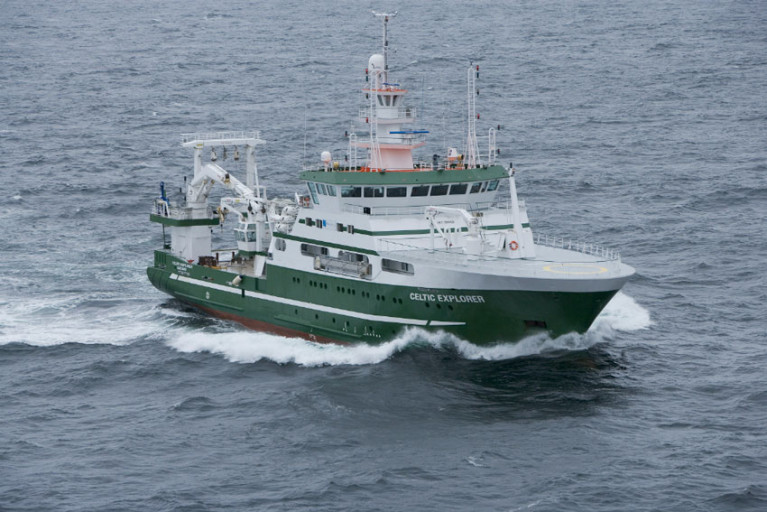
The survey will be conducted from the RV Celtic Explorer (callsign EIGB) which will be towing a Jackson demersal trawl and will display appropriate lights and signals.

All marine operators, especially those engaged in commercial fishing, are requested to keep a 3mn area around the indicated tow points clear of any gear or apparatus during the survey period.

Published in Fishing

Building on the success of pilot programmes in 2019 and 2020, the Tuna CHART (CatcH And Release Tagging) fishery to collect scientific data on bluefin tuna will return in 2021, subject to COVID-19 restrictions.

Tuna CHART is a collaborative scientific programme between Inland Fisheries Ireland and the Marine Institute in partnership with the Sea Fisheries Protection Authority, the Department of Agriculture, Food and the Marine (DAFM) and the Department of Environment, Climate and Communications (DECC).

In 2020, the Tuna CHART programme authorised 22 charter skippers to operate a scientific fishery — in which anglers participated fully — to catch, tag and release bluefin tuna. These professional skippers were trained to tag, measure and record bluefin data.

Despite the limitations of the pandemic, 685 bluefin tuna were caught, tagged and released around the Irish coast — a 230% increase in bluefin tagged on the previous year.

File image of bluefin tuna in Donegal Bay (Photo: David Morrissey)
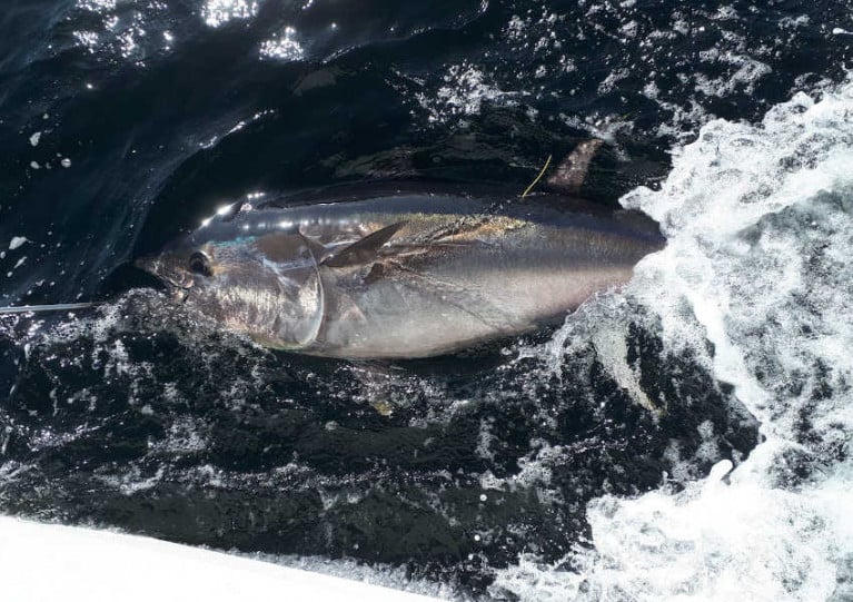
File image of bluefin tuna in Donegal Bay Photo: David Morrissey

The most productive sites were the North-West and the South coast, mainly the waters of the Cork coastline. As many as 11 bluefin were tagged on one angling trip, a new Irish record. The largest tuna tagged was 275cm, weighing an estimated 822lbs.

All tuna were carefully handled subject to strict guidelines set by the Tuna CHART programme and all were released alive. Data from the tagging programme has been collated by the partnership for reporting to the International Commission for the Conservation of Atlantic Tuna (ICCAT).

This year a maximum of 25 authorisations may be granted to qualifying vessels and skippers around the Irish coast for fishing between 1 July and 12 November. Applications are now open and will be accepted until 1pm on Friday 9 April.

Depending on the successful operation and review of this year’s fishery, it is intended that a scientific catch-and-release fishery may also operate in 2022.

The partnership says a core aspect of the Tuna CHART programme is the welfare and successful release of the bluefin tuna. Authorised skippers will be required to have high specification rods, reels and line in advance of the open season in order to ensure that the fish is brought alongside the vessel to be measured and tagged in the water in a timely manner.

Data collection for scientific assessment is the primary purpose of the fishery and will continue to be a key requirement for skipper participation in this scientific catch-and-release fishery, the partnership adds.

Skippers will be required to collect data on every bluefin trip undertaken and each bluefin tuna they catch, tag and release, and their angling and data recording expertise is an important part of the overall survey programme.

Anglers will have an opportunity to participate in this fishery and contribute to this important scientific study by chartering and fishing from authorised vessels only. Unauthorised vessels are not permitted to target or catch bluefin tuna, and any unauthorised person found to be targeting bluefin tuna will be prosecuted. Applications for authorisations are open to charter skippers only.

Published in Angling

The Irish Whale and Dolphin Group (IWDG) won the tender to provide a marine mammal observer on three fisheries acoustic surveys with the Marine Institute this year.

These include a survey for blue whiting this month, the Western European Shelf Pelagic Acoustic (WESPAS) survey during June and July and the Celtic Sea Herring Acoustic Survey in October.

The aforementioned missions are annual stock assessment surveys and cover a huge area of the Irish EEZ.

Data on higher trophic predators such as marine mammals and seabirds are essential to provide the data to support the development of an ecosystem approach to fisheries management.

Experienced offshore surveyor Dr Justin Judge will be joining each cruise to record all sightings of whales and dolphins and other interesting endangered, threatened and protected (ETP) species, as well as recording the vessels’ track and environmental conditions.

He follows in the footsteps of Dave Wall, who used data collected from these annual surveys in 2014 to built the dataset to publish the first Offshore Atlas of Marine Mammal Distribution.

Published in Marine Wildlife
Tagged under

On Thursday 25th February 2021, the Marine Institute will host the Burrishoole Research Day, a virtual symposium showcasing the wide network of researchers connected to the Marine Institute’s Newport Research Facility in Co Mayo.

The symposium will include short talks from 26 researchers representing seven Irish and UK Higher Education Institutions, including the Marine Institute. Researchers will share insights into their research projects and advances in areas such as climate change, fish telemetry, genomics, aquaculture and ecological change.

The Newport Research Facility in Co Mayo has been in operation since 1955, and has been part of the Marine Institute since 1999. Located at the base of the Burrishoole catchment, the facility is located at the interface of the freshwater and marine ecosystems. The combination of the unique location, and long time series of environmental datasets have attracted national and international researchers to the facility for many decades.

Fisheries research at the Newport Research Facility focuses on migration, ecology, genetics, population dynamics and management advice for species including salmon, sea trout, eel, sea bass, blue fin tuna, pollack and stickleback. There are also a range of research projects on the impacts of climate and land use change on aquatic ecosystems, limnology, oceanography and sustainable aquaculture.

Researchers based at the Marine Institute’s Newport Research Facility have secured competitive funding in a number of research areas. As part of the Marine Institute’s Cullen Scholarship Programme, a number of postgraduate students have also been based at the Newport Research Facility to work on projects relevant to the Marine Institute whilst studying for a higher degree. The resulting research network, encompassing researchers from the Marine Institute and Higher Education Institutes, is diverse and collaborative. This symposium will highlight progress on research projects in the last three years, as well as introduce some new projects.

The symposium will include four sessions via Zoom from 10am to 4pm on Thursday 25th February 2021. To access the programme and the Zoom link, email [email protected]

Published in Marine Science

The Marine Institute is recruiting for a physical oceanographer to join its existing team of oceanographers and modellers to gather, analyse and generate services from oceanographic data.

The oceanographer will support the institute’s data collection at sea and work with data management colleagues to robustly archive, quality assure and analyse the oceanographic datasets of interest to users.

These include — but are not limited to — tide gauges, offshore weather buoys, conductivity, temperature and depth (CTD) profiles from ships, CTD from moored platforms, ocean gliders, Argo floats and acoustic Doppler current profilers (ADCP).

This temporary specified purpose contract of employment, providing redeployment cover, will run for up to 31 December 2023. The successful candidate will be on probation for the first six months.

A detailed job description is available from the Marine Institute website, and the closing date for applications is Wednesday 24 February at 12 noon.

Published in Marine Science

Some 30 per cent of researchers worldwide are female, according to UNESCO which marks International Day of Women and Girls in Science this week

About 35 per cent of all students in STEM-related fields – that’s science, technology, engineering and maths – are women, UNESCO says.

However, about 51 per cent of staff at the Marine Institute in Galway are female, and about 70 per cent hold key roles in science, technical analysis and research, extending from oceanography and ocean climate to fishery ecosystems, marine environment and food safety.

Marine Institute director of corporate services Patricia Orme says the organisation also has women working in policy, innovation and research, maritime development and corporate roles.

“We are extremely proud to note that 80% of our female employees hold bachelor, masters or doctorate level qualifications," she says.

Wavelengths spoke to three of those women – starting with postdoctoral researcher Julia Calderwood who is involved in designing what will be a very useful app for the fishing industry to help reduced unwanted catches as part of the IFish project funded by Science Foundation Ireland.

lizabeth Tray, from North Carolina, is team leader for data co-ordination and reporting on marine spatial planninglizabeth Tray, from North Carolina, is team leader for data co-ordination and reporting on marine spatial planning

Elizabeth Tray, from North Carolina, is team leader for data coordination and reporting on marine spatial planning and the EU’s Marine Strategy Framework Directive.

Yvonne Bogan from Donegal took her PhD in marine biotoxins and formerly worked with the Environmental Protection Agency. She is now quality manager team leader with the Marine Institute.

Yvonne Bogan of the Marine InstituteYvonne Bogan, a quality manager team leader with the Marine Institute

For more profiles of female scientists in marine research, follow #WomenInScience on the Marine Institute’s Facebook, Twitter and Instagram pages.

You can listen to Wavelengths below

Published in Wavelength Podcast

The Marine Institute is inviting marine science undergraduates to apply for a number of work experience placements as part of the 2021 Summer Bursary Scholarship Programme.

This year the programme will offer a number of eight- to 12-week placements for up to 11 undergraduate students who will be based at either the Marine Institute headquarters in Oranmore, Co Galway or the research facility at Newport, Co Mayo.

The programme offers students practical experience in areas such as freshwater fisheries, salmon scale archiving, aquaculture, oceanography data sets, marine infrastructure asset management, finance, human resources and marine communications.

As previously reported on Afloat.ie, the Bursary Scholarship Programme has been running for over 30 years, providing essential career development and support, and inspiring the next generation of marine scientists and experts. It is aimed at undergraduates of universities, institutes of technology and national institutes for higher education.

To participate in the programme, undergraduate students must have completed two years of study in a relevant discipline by the beginning of June 2021. Successful applicants will receive a scholarship worth €275 per week for the duration of the work placement.

To apply for the 2021 Bursary Programme:

  • View the bursary titles available
  • Select the two bursary positions that interest you the most and in order of preference
  • Complete the application form and return it FAO Helen McCormick, Marine Institute, Rinville, Oranmore, Galway, H91 R673

The application deadline date is Friday 26 February.

Published in Marine Science

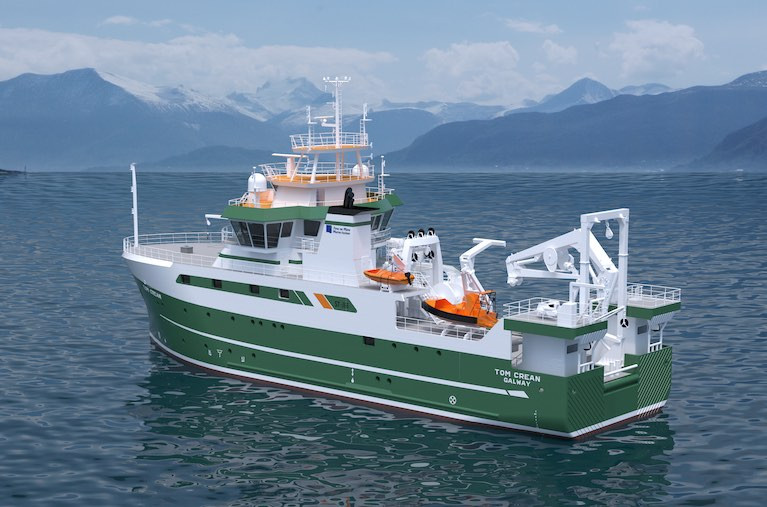
As Afloat first highlighted the Marine Institute's name of RV Tom Crean chosen for the new €25m research vessel due for delivery in Autumn 2022, is to feature a suite of the latest state of the art technology equipment, writes Jehan Ashmore.

RV Tom Crean of 52.8m will be one of world's most advanced research vessels is to directly replace the smaller RV Celtic Voyager of 31.40m and of 23 years service having operated duties in more inshore waters.

While the larger fleetmate, RV Celtic Explorer of 65.5m dating to 2003 will be joined by the newbuild to carry out an extensive capability of marine research activities. They include vital fisheries data (incl. EU Common Fisheries Policy), Irish seabed mapping (INFOMAR) and oceanography and critical climate change related research given this year marks the start of the UN Decade of the Ocean (2021-2030) and its urgency.

The newbuild was commissioned by the Department of Agriculture, Food and the Marine with the approval of the Government of Ireland, to enable the State's national integrated marine plan, 'Harnessing Our Ocean Wealth' and the national Marine Research and Innovation Strategy.

Afloat can also reveal that RV Tom Crean will be around 1,900 gross registered tonnes, with the first block laid down on 4th November last year at the Spanish shipyard of Astilleros Armon Vigo S.A. So far, 19 out of 32 block sections constructed are in place, with September 2021 scheduled for starting a 'fitting-out' period of the semi-completed newbuild prior to the newbuild's commissioning around a year later.

The shipyard is working to a design of Norwegian naval architects, Skipsteknisk AS based in Ålesund which was awarded the work following a EU tender process. The design consultancy were also responsible for the RV Celtic Explorer which will be joined by RV Tom Crean in the M.I.'s homeport of Galway, strategically located on the western seaboard and with easy access to the North Atlantic Ocean.

Afloat contacted the Marine Institute since (their press release), for further details of the RV Tom Crean characteristics, in particular the all important aft work deck, where the primary action is to take place in water operations in depths down to 4,000m.

According to Aodhán FitzGerald, Research Vessel Manager of the MI, the RV Tom Crean will feature an articulated boom crane aft (6t@ 10m, 3T@ 15m), located on the aft-gantry. This will be largely used for loading science equipment and net and equipment handling offshore.

Mounted at the stern is a 10T A frame aft which can articulate through 170 degrees which is for deploying and recovering large science equipment such as remotely operated vehicle (ROV’s), towed sleds and for fishing operations.

The vessel also has a heave compensated CTD system (system for measuring water temperature, salinity and depth  and for collecting water samples) consisting of a deepwater winch and Frame to allow CTD operations in water depths down to 4000m.

Part of the equippment will be a regulation MOB boat on a dedicated davit and the facility to carry a 6.5m Rigid Inflatable tender on the port side.

Also at the aft deck is where the 'Holland 1' Work class ROV and the University of Limericks 'Etain' sub Atlantic ROV will be positioned. In addition up to 3 x 20’ (TEU) containers can be carried.

The newbuild has been engineered to endure increasing harsher conditions and the punishing weather systems encountered in the North-East Atlantic where deployments of RV Tom Crean on surveys spent up to 21 days duration.

In addition, RV Tom Crean will be able to operate in an ultra silent-mode, which is crucial to meet the stringent criteria of the ICES 209 noise standard for fisheries research purposes.

Of course all this broad-tasking can only be achieved with a team combining 12 crew and 14 scientists accommodated in the research vessel with associated laboratory facilities. In addition there will also be an on board hospital.

Published in RV Tom Crean
Page 13 of 48

General Information on using Waterways Ireland inland navigations

Safety on the Water

All users of the navigations are strongly recommended to make themselves aware of safety on the water for whatever activity they are involved in and to read the advice offered by the various governing bodies and by:

The Dept. of Transport, Ireland: www.gov.ie/transport and The Maritime and Coastguard Agency, UK, The RNLI – Water Safety Ireland for information in terms of drowning prevention and water safety.

Registration of Vessels

All vessels using the Shannon Navigation, which includes the Shannon-Erne Waterways and the Erne System must be registered with Waterways Ireland. Only open undecked boats with an engine of 15 horsepower or less on the Shannon Navigation, and vessels of 10 horsepower or less on the Erne System, are exempt. Registration is free of charge.

Craft registration should be completed online at: https://www.waterwaysireland.org/online-services/craft-registration

Permits for use of the Grand and Royal Canals and the Barrow Navigation

All vessels using the Grand and Royal Canals and the Barrow Navigation must display appropriate valid Permit(s) i.e A Combined Mooring and Passage Permit (€126) and if not intending to move every five days, an Extended Mooring Permit (€152).

Permit applications should be completed online at: https://www.waterwaysireland.org/online-services/canal-permits

Passage on the Royal and Grand Canals – Dublin Area

For boat passage through the locks east of Lock 12 into / out of Dublin on either the Royal or Grand Canals, Masters are requested to contact the Waterways Ireland Eastern Regional Office (M-F 9.30am-4.30pm) on tel: +353(0)1 868 0148 or email [email protected] prior to making passage in order to plan the necessary lock-keeping assistance arrangements.

On the Grand Canal a minimum of two days notice prior to the planned passage should be given, masters should note that with the exception of pre-arranged events, a maximum of 2 boats per day will be taken through the locks, travelling either east or west.

Movements in or out of the city will be organised by prior arrangement to take place as a single movement in one day. Boaters will be facilitated to travel the system if their passage is considered to be safe by Waterways Ireland and they have the valid permit(s) for mooring and passage.

Newcomen Lifting Bridge

On the Royal Canal two weeks’ notice of bridge passage (Newcomen Lifting Bridge) is required for the pre-set lift date, and lock assistance will then also be arranged. A minimum of 2 boats is required for a bridge lift to go ahead.

Waterways Ireland Eastern Regional Office (Tel: +353(0)1 868 0148 or [email protected] ) is the point of contact for the bridge lift.

A maximum number of boats passing will be implemented to keep to the times given above for the planned lifts (16 for the Sat / Sun lifts & 8 for the weekday lifts). Priority will be given on a first come first served basis.

On day of lift, boaters and passengers must follow guidance from Waterways Ireland staff about sequence of passage under bridge & through Lock 1, and must remain within signed and designated areas.

Events Held on the Waterways

All organised events taking place on the waterways must have the prior approval of Waterways Ireland. This is a twelve week process and application forms must be accompanied with the appropriate insurance, signed indemnity and risk assessment. The application should be completed on the Waterways Ireland events page at :

https://www.waterwaysireland.org/online-services/event-approval

Time Limits on Mooring in Public Harbours

On the Shannon Navigation and the Shannon-Erne Waterway craft may berth in public harbours for five consecutive days or a total of seven days in any one month.

On the Erne System, revised Bye Laws state that: No master or owner shall permit a vessel, boat or any floating or sunken object to remain moored at or in the vicinity of any public mooring, including mooring at any other public mooring within 3 kilometres of that location, for more than 3 consecutive days and shall not moor at that same mooring or any other public mooring within 3 kilometres of that location within the following 3 consecutive days without prior permission by an authorised official.

Winter Mooring on the Shannon Navigation and Shannon Erne Waterway

Winter mooring may be availed of by owners during the period 1 Nov to 31 Mar by prior arrangement and payment of a charge of €63.50 per craft. Craft not availing of Winter Mooring must continue to comply with the “5 Day Rule”. Winter Mooring applications should be completed online at : https://www.waterwaysireland.org/online-services/winter-moorings-booking

Owners should be aware that electricity supply and water supply to public moorings is disconnected for the winter months. This is to protect against frost damage, to reduce running costs and to minimise maintenance requirements during the winter months.

Vessel owners are advised that advance purchasing of electricity on the power bollards leading up to the disconnection date should be minimal. Electricity credit existing on the bollards will not be recoverable after the winter decommissioning date. Both services will be reinstated prior to the commencement of the next boating season.

Smart Cards

Waterways Ireland smart cards are used to operate locks on the Shannon Erne Waterway, to access the service blocks, to use the pump-outs along the navigations, to avail of electrical power at Waterways Ireland jetties.

Berthing in Public Harbours

Masters are reminded of the following:

  • Equip their vessel with mooring lines of appropriate length and strength and only secure their craft to mooring bollards and cleats provided for this purpose.
  • Ensure the available berth is suitable to the length of your vessel, do not overhang the mooring especially on finger moorings on floating pontoon moorings.
  • Ensure mooring lines, electric cables and fresh water hoses do not create a trip hazard on public jetties for others users.
  • Carry sufficient fenders to prevent damage to your own vessel, other vessels and WI property.
  • Allow sufficient space between your vessel and the vessel ahead /astern (c.1m) for fire safety purposes and /or to recover somebody from the water.
  • Do not berth more than two vessels side by side and ensure there is safe access/egress at all times between vessels and onto the harbour itself.
  • Do not berth in such a way to prevent use of harbour safety ladders, slipways or pump-outs.
  • Do not allow the bow of your vessel to overhang the walkway of a floating mooring thus creating a hazard for others with an overhanging anchor or bow fendering.
  • Animals are not allowed to be loose or stray at any time.
  • Harbour and jetty infrastructure such as railings, power pedestals, fresh water taps, electric light poles, safety bollards, ladders etc are not designed for the purpose of mooring craft , they will not bear the strain of a vessel and will be damaged.
  • At Carrybridge on the Erne System, Masters of vessels are not permitted to use stern on mooring. Masters of vessels must use the mooring fingers for mooring of vessels and for embarkation / disembarkation from vessels.

Passenger Vessel Berths

Masters of vessels should not berth on passenger vessel berths where it is indicated that an arrival is imminent. Passenger vessels plying the navigations generally only occupy the berths to embark and disembark passengers and rarely remain on the berths for extended periods or overnight.

Lock Lead-in Jetties

Lead-in jetties adjacent to the upstream and downstream gates at lock chambers are solely for the purpose of craft waiting to use the lock and should not be used for long term berthing.

Vessel Wake

Vessel wake, that is, the wave generated by the passage of the boat through the water, can sometimes be large, powerful and destructive depending on the hull shape and engine power of the vessel. This wake can be detrimental to other users of the navigation when it strikes their craft or inundates the shoreline or riverbank. Masters are requested to frequently look behind and check the effect of their wake / wash particularly when passing moored vessels, on entering harbours and approaching jetties and to be aware of people pursuing other activities such as fishing on the riverbank.

Speed Restriction

A vessel or boat shall not be navigated on the Shannon Navigation at a speed in excess of 5 kph when within 200 metres of a bridge, quay, jetty or wharf, when in a harbour or canal or when passing within 100 metres of a moored vessel or boat.

Vessels navigating the Shannon-Erne Waterway should observe the general 5 kph speed limit which applies along the waterway. This is necessary in order to prevent damage to the banks caused by excessive wash from vessels.

Vessels navigating the Erne System should observe the statutory 5kt / 6mph / 10kph speed limit areas.

A craft on the Royal and Grand canals shall not be navigated at a speed in excess of 6km per hour.

A craft on the Barrow Navigation shall not be navigated at a speed in excess of 11km per hour except as necessary for safe navigation in conditions of fast flow.

Bank Erosion

Narrow sections of all the navigations are particularly prone to bank erosion due to the large wash generated by some craft. Masters are requested to be vigilant and to slow down to a speed sufficient to maintain steerage when they observe the wash of their craft inundating the river banks.

Unusual Waterborne Activity

Unusual waterborne vessels may be encountered from time to time, such as, hovercraft or amphibious aircraft / seaplanes. Masters of such craft are reminded to apply the normal “Rule of the Road” when they meet conventional craft on the water and to allow extra room to manoeuvre in the interest of safety.

Sailing Activity

Mariners will encounter large numbers of sailing dinghies from late June to August in the vicinity of Lough Derg, Lough Ree and Lower Lough Erne. Sailing courses are marked by yellow buoys to suit weather conditions on the day. Vessels should proceed at slow speed and with due caution and observe the rules of navigation when passing these fleets, as many of the participants are junior sailors under training.

Rowing

Mariners should expect to meet canoes and vessels under oars on any part of the navigations, but more so in the vicinity of Athlone, Carrick-on-Shannon, Coleraine, Enniskillen and Limerick. Masters are reminded to proceed at slow speed and especially to reduce their wash to a minimum when passing these craft as they can be easily upset and swamped due to their very low freeboard and always be prepared to give way in any given traffic situation.

Canoeing

Canoeing is an adventure sport and participants are strongly recommended to seek the advice of the sport’s governing bodies i.e Canoeing Ireland and the Canoe Association of Northern Ireland, before venturing onto the navigations.

Persons in charge of canoes are reminded of the inherent danger to these craft associated with operating close to weirs, sluice gates, locks and other infrastructure particularly when rivers are in flood and large volumes of water are moving through the navigations due to general flood conditions or very heavy localised precipitation e.g. turbulent and broken water, stopper waves. Shooting weirs is prohibited without prior permission of Waterways Ireland.

Canoeists should check with lockkeepers prior entering a lock to ensure passage is done in a safe manner. Portage is required at all unmanned locks.

Canoe Trail Network – "Blueways"

Masters of powered craft are reminded that a canoe trail network is being developed across all navigations and to expect more organised canoeing along these trails necessitating slow speed and minimum wash when encountering canoeists, rowing boats etc

Rockingham and Drummans Island Canals – Lough Key

It is expected that work on Rockingham and Drummans Island Canals on Lough Key will be completed in 2021. Access to these canals will be for non-powered craft only, eg canoes, kayaks, rowing boats.

Fast Powerboats and Personal Watercraft (Jet Skis)

Masters of Fast Powerboats (speed greater than 17kts) and Personal Watercraft (i.e.Jet Skis) are reminded of the inherent dangers associated with high speed on the water and especially in the confines of small bays and narrow sections of the navigations. Keeping a proper look-out, making early alterations to course and /or reducing speed will avoid conflict with slower vessels using the navigation. Personal Watercraft are not permitted to be used on the canals.

Towing Waterskiers, Wakeboarders, Doughnuts etc

Masters of vessels engaged in any of these activities are reminded of the manoeuvring constraints imposed upon their vessel by the tow and of the added responsibilities that they have to the person(s) being towed. These activities should be conducted in areas which are clear of conflicting traffic. It is highly recommended that a person additional to the master be carried to act as a “look-out” to keep the tow under observation at all times.

Prohibition on Swimming

Swimming in the navigable channel, particularly at bridges, is dangerous and is prohibited due to the risk of being run over by a vessel underway in the navigation.

Age Restrictions on operating of powered craft

In the Republic of Ireland, Statutory Instrument 921 of 2005 provides the legal requirements regarding the minimum age for operating of powered craft. The Statutory Instrument contains the following requirements:

- The master or owner of a personal watercraft or a fast power craft shall take all reasonable steps to ensure that a person who has not attained the age of 16 years does not operate or control the craft

- The master or owner of a pleasure craft powered by an engine with a rating of more than 5 horse power or 3.7 kilowatts shall take all reasonable steps to ensure that a person who has not attained the age of 12 years does not operate or control the craft.

Lifejackets and Personal Flotation Devices (PFDs)

Lifejackets and PFD’s are the single most important items of personal protective equipment to be used on a vessel and should be worn especially when the vessel is being manoeuvred such as entering / departing a lock, anchoring, coming alongside or departing a jetty or quayside.

In the Republic of Ireland, Statutory Instrument 921 of 2005 provides the legal requirements regarding the wearing of Personal Flotation Devices. The Statutory Instrument contains the following requirements:

- The master or owner of a pleasure craft (other than a personal watercraft) shall ensure, that there are, at all times on board the craft, sufficient suitable personal flotation devices for each person on board.

- A person on a pleasure craft (other than a personal watercraft) of less than 7 metres length overall shall wear a suitable personal flotation device while on board an open craft or while on the deck of decked craft, other than when the craft is made fast to the shore or at anchor.

- The master or owner of a pleasure craft (other than a personal watercraft) shall take all reasonable steps to ensure that a person who has not attained the age of 16 years complies with paragraph above.

- The master or owner of a pleasure craft (other than a personal watercraft), shall take all reasonable steps to ensure that a person who has not attained the age of 16 years wears a suitable personal flotation device while on board an open craft or while on the deck of a decked craft other than when it is made fast to the shore or at anchor.

- The master or owner of a pleasure craft (other than a personal watercraft) shall take all reasonable steps to ensure that a person wears a suitable personal flotation device, at all times while – (a) being towed by the craft, (b) on board a vessel or object of any kind which is being towed by the craft.

Further information is available at: http://www.irishstatutebook.ie/eli/2005/si/921/made/en/print

Firing Range Danger Area – Lough Ree

The attention of mariners is drawn to the Irish Defence Forces Firing Range situated in the vicinity of buoys No’s 2 and 3, on Lough Ree on the Shannon Navigation. This range is used regularly for live firing exercises, throughout the year, all boats and vessels should stay clear of the area marked with yellow buoys showing a yellow "X" topmark and displaying the word "Danger".

Shannon Navigation, Portumna Swing Bridge Tolls

No attempt should be made by Masters’ of vessels to pay the bridge toll while making way through the bridge opening. Payment will only be taken by the Collector from Masters when they are secured alongside the jetties north and south of the bridge.

Navigating from Killaloe to Limerick on the Shannon Navigation

The navigation from Killaloe to Limerick involves passage through Ardnacrusha locks, the associated headrace and tailrace and the Abbey River into Limerick City. Careful passage planning is required to undertake this voyage. Considerations include: lock passage at Ardnacrusha, water flow in the navigation, airdraft under bridges on Abbey River in Limerick, state of tide in Limerick

Users are advised to contact the ESB Ardnacrusha hydroelectric power station (00353 (0)87 9970131) 48 hours in advance of commencing their journey to book passage through the locks at Ardnacrusha. It is NOT advised to undertake a voyage if more than one turbine is operating (20MW), due to the increased velocity of flow in the navigation channel, which can be dangerous. To ascertain automatically in real time how many turbines are running, users can phone +353 (0)87 6477229.

For safety reasons the ESB has advised that only powered craft with a capacity in excess of 5 knots are allowed to enter Ardnacrusha Headrace and Tailrace Canals.

Passage through Sarsfield Lock should be booked on +353-87-7972998, on the day prior to travel and it should be noted also that transit is not possible two hours either side of low water.

A Hydrographic survey in 2020 of the navigation channel revealed that the approach from Shannon Bridge to Sarsfield Lock and the Dock area has silted up. Masters of vessels and water users are advised to navigate to the Lock from Shannon bridge on a rising tide one or two hours before High Tide.

Lower Bann Navigation

The attention of all users is drawn to the “Users Code for the Lower Bann”, in particular to that section covering “Flow in the River” outlining the dangers for users both on the banks and in the navigation, associated with high flow rates when the river is in spate. Canoeists should consult and carry a copy of the “Lower Bann Canoe Trail” guide issued by the Canoe Association of Northern Ireland. Users should also contact the DfI Rivers Coleraine, who is responsible for regulating the flow rates on the river, for advisory information on the flow rates to be expected on any given day.

DfI Rivers Coleraine. Tel: 0044 28 7034 2357 Email: [email protected]

Lower Bann Navigation – Newferry – No wake zone

A No Wake Zone exists on the Lower Bann Navigation at Newferry. Masters of vessels are requested to proceed at a slow speed and create no wake while passing the jetties and slipways at Newferry.

Overhead Power Lines (OHPL) and Air draft

All Masters must be aware of the dangers associated with overhead power lines, in particular sailing vessels and workboats with cranes or large air drafts. Voyage planning is a necessity in order to identify the location of overhead lines crossing the navigation.

Overhead power line heights on the River Shannon are maintained at 12.6metres (40 feet) from Normal Summer level for that section of navigation, masters of vessels with a large air draft should proceed with caution and make additional allowances when water levels are high.

If a vessel or its equipment comes into contact with an OHPL the operator should NOT attempt to move the vessel or equipment. The conductor may still be alive or re-energise automatically. Maintain a safe distance and prevent third parties from approaching due to risk of arcing. Contact the emergency services for assistance.

Anglers are also reminded that a minimum ground distance of 30 metres should be maintained from overhead power lines when using a rod and line.

Submarine Cables and Pipes

Masters of vessels are reminded not to anchor their vessels in the vicinity of submarine cables or pipes in case they foul their anchor or damage the cables or pipes. Look to the river banks for signage indicating their presence.

Water Levels - Precautions

Low Water Levels:

When water levels fall below normal summer levels masters should be aware of:

Navigation

To reduce the risk of grounding masters should navigate on or near the centreline of the channel, avoid short cutting in dog-legged channels and navigating too close to navigation markers.

Proceeding at a slow speed will also reduce “squat” effect i.e. where the vessel tends to sit lower in the water as a consequence of higher speed.

Slipways

Reduced slipway length available under the water surface and the possibility of launching trailers dropping off the end of the concrete apron.

More slipway surface susceptible to weed growth requiring care while engaged in launching boats, from slipping and sliding on the slope. Note also that launching vehicles may not be able to get sufficient traction on the slipway once the craft is launched to get up the incline.

Bank Erosion

Very dry riverbanks are more susceptible to erosion from vessel wash.

Lock Share

Maximising on the number of vessels in a lock will ensure that the total volume of water moving downstream is decreased. Lock cycles should be used for vessels travelling each way.

High Water Levels:

When water levels rise above normal summer level masters should be aware of:

Navigation

Navigation marks will have reduced height above the water level or may disappear underwater altogether making the navigable channel difficult to discern.

In narrow sections of the navigations water levels will tend to rise more quickly than in main streams and air draft at bridges will likewise be reduced.

There will also be increased flow rates particularly in the vicinity of navigation infrastructure such as bridges, weirs, locks etc where extra care in manoeuvring vessels will be required.

Harbours and Jetties

Due care is required in harbours and at slipways when levels are at or near the same level as the harbour walkways' as the edge will be difficult to discern especially in reduced light conditions. It is advised that Personal Flotation Devices be worn if tending to craft in a harbour in these conditions.

Slipways

Slipways should only be used for the purpose of launching and recovering of water craft or other objects from the water. Before using a slipway it should be examined to ensure that the surface has sufficient traction/grip for the intended purpose such as launching a craft from a trailer using a vehicle, that there is sufficient depth of water on the slipway to float the craft off the trailer before the concrete apron ends and that the wheels of the trailer do not drop off the edge of the slipway. That life-saving appliances are available in the vicinity, that the vehicle is roadworthy and capable of coping with the weight of the trailer and boat on the incline. It is recommended that slipway operations are conducted by two persons.

Caution to be Used in Reliance upon Aids to Navigation

The aids to navigation depicted on the navigation guides comprise a system of fixed and floating aids to navigation. Prudent mariners will not rely solely on any single aid to navigation, particularly a floating aid to navigation. With respect to buoys, the buoy symbol is used to indicate the approximate position of the buoy body and the ground tackle which secures it to the lake or river bed. The approximate position is used because of the practical limitations in positioning and maintaining buoys in precise geographical locations. These limitations include, but are not limited to, prevailing atmospheric and lake/river conditions, the slope of and the material making up the lake/river bed, the fact that the buoys are moored to varying lengths of chain, and the fact that the buoy body and/or ground tackle positions are not under continuous surveillance. Due to the forces of nature, the position of the buoy body can be expected to shift inside and outside the charted symbol.

Buoys and perches are also moved out of position or pulled over by those mariners who use them to moor up to instead of anchoring. To this end, mariners should always monitor their passage by relating buoy/perch positions with the published navigation guide. Furthermore, a vessel attempting to pass close by always risks collision with a yawing buoy or with the obstruction that the buoy or beacon/perch marks.

Masters of Vessels are requested to use the most up to date Navigation guides when navigating on the Inland Waterways.

Information taken from Special Marine Notice No 1 of 2023