Menu

Ireland's sailing, boating & maritime magazine

Inland afloat headers


Displaying items by tag: James Joyce

The Irish Naval Vessel  LÉ James Joyce was positioned off Sandycove Point on Dublin Bay for over an hour today, close to the Martello Tower made famous by Irish writer James Joyce in his novel Ulysses.

The special Bloomsday tribute was made by the ship that was named after the author in 2015.

LE James Joyce departed Dún Laoghaire Harbour at 1430hrs and made its way across Scotsman's Bay where there were a number of shoreside Joycean gatherings being held.

Bloomsday celebrates Joyce's iconic Ulysses through performances, meals, readings, and dressing-up, especially at Sandycove.

As part of the celebrations, LÉ James Joyce flew "the oldest flag afloat, the flag of the province of Desmond & Thomond, three crowns on a blue field, the three sons of Milesius," as Joyce describes in Ulysses.

The Irish Naval Vessel  LÉ James Joyce (left) was positioned off Sandycove Point on Dublin Bay, close to the Martello Tower (right) on BloomsdayThe Irish Naval Vessel  LÉ James Joyce (left) was positioned off Sandycove Point on Dublin Bay, close to the Martello Tower (right) on Bloomsday.

The Napoleonic tower is where the author spent six nights in 1904. The opening scenes of his 1922 novel Ulysses take place there, and the building is a place of pilgrimage for Joyce enthusiasts, especially on Bloomsday.

Published in Dublin Bay

In Ulysses Mr Deasy, headmaster of a private school, writes to the newspapers complaining that he knows of a cure for foot and mouth disease but nobody in authority will listen to him. Mr Deasy grandly compares his nebulous proposal to a major project from the 1850s which aimed to attract a growing transatlantic passenger traffic to Galway. Deasy calls to mind the “Liverpool ring which jockeyed the Galway harbour scheme” and describes himself as “surrounded by difficulties, by… intrigues, by… backstairs influence”.

The Galway Harbour scheme was no creation in a novelist's mind. Sixty years before Ulysses there was such a project and James Joyce was well informed about it. The project’s driving force was a dynamic priest named Fr. Peter Daly. Fr. Daly undertook various religious and welfare projects in Galway during the famine years and later involved himself in public life. He was a director of the Galway Gas Company and Chair of Galway Town Commissioners. As a board member of Midland & Great Western Railway Fr. Daly was instrumental in ensuring that the railway did not, as intended, end at Rahoon but reached Galway. He went on to ensure and oversee the construction of the then largest hotel in Ireland at Eyre Square.

Fr. Daly was also a member of Galway Harbour Commissioners and he sought to extend the new railway out to a proposed deep-water passenger facility at Furbo. He saw this as the final link in a chain which would allow ship-owners to offer a through-fare from Hamburg and points along the way across England and Ireland to New York. Such operators would have both a speed and a price advantage which would draw transatlantic traffic into Galway.

All his life Joyce was superstitious about dates and 16th June had special significance for him because it was on 16th June 1904 that he and Nora, his future wife, first walked out together in Dublin. That is why he places Ulysses in Dublin on 16th of June 1904 and why Bloomsday is celebrated around the world each year on 16th June. It is also why he was fascinated by the Galway Harbour scheme for which 16th June 1858 would prove portentous.

Later in Ulysses another voice speaks to the same subject when the putative Skin-the-Goat, keeper of the Cabman’s Shelter on Dublin’s Customs House Quay, laments the state of shipping in Ireland:

“ What he wanted to ascertain was why that ship ran bang against the only rock in Galway Bay when the Galway Harbour scheme was mooted…Ask her captain….how much palmoil the British Government gave him for that day’s work. Captain John Lever of the Lever line. -Am I right skipper? he queried of the sailor…”

A 1904 cabman's shelterA 1904 cabman's shelter

This is a reference the ship-owner John Orrell Lever who amassed profits chartering ships for the Crimean war and became interested in Galway for the development of a transatlantic passenger service to rival those of Liverpool and the ports of mainland Europe.

Several hundred Irish investors put up capital for his new company known as The Galway Line. The new service began in 1858 with Indian Empire which was the largest ship up to that time to enter the port of Galway and her arrival was widely anticipated.

On 16th June 1858, as two pilots were guiding her to port, Indian Empire grounded on the Margaretta Rock. Two and a half hours later, on a rising tide, the pilots managed to reverse her off and the steamship proceeded to anchorage with slight damage to her hull. She took on coal, cargo and passengers and on 19th June Indian Empire sailed for New York via Halifax.

However, on the day she had docked Captain Courteney, his crew and pilots were brought before an emergency meeting of Galway Harbour Commissioners. Rumours had begun to circulate about the grounding and a hostile crowd gathered. The pilots had to be protected by the police. Newspapers reported comments that the grounding was likely to turn out to be an attempt to wreck the ship in order to destroy the Galway harbour scheme. There was great discussion in public of plots, sabotage and especially “Liverpool gold at work”. Much was made of the fact that Lever had recruited the pilots in England. Reports were relayed outside Ireland as speculation lingered. Criminal charges were begun against the pilots. The sudden death of one of the pilots brought only more rumours and further press reports. Nowadays the position would be described as a publicity storm amplified by the absence of a media strategy and the credibility of the harbour project was diminished.

We know that Joyce was very taken with this tale and it is especially interesting that in Ulysses he leaves the final word on the subject to a sailor, Able seaman Murphy:

That worthy, picking up the scent of the fagend of the song or words, growled in wouldbe music, but with great vim, some kind of shanty…

- The biscuits was as hard as brass,
And the beef as salt as Lot’s wife’s’ arse.
O Johnny Lever!
Johnny Lever O!

Published in Galway Harbour

With Bloomsday on Thursday, June 16th, the ongoing Centenary of the publication of James Joyce's Ulysses will see even more local links to the great work and its author being highlighted and celebrated in many ways in several places.

Noted maritime historian and archivist Cormac Lowth is mining a rich and varied source in this presentation (open to all) which he will be giving in Ringsend Library on Thursday morning.

Published in Dublin Bay
Tagged under

On the 16th June each year people come from far and wide dressed in Edwardian attire to walk, talk and perform around Dublin in commemoration of James Joyce's famous modernist novel "Ulysses". You see lots of bowler hats, parasols and long dresses but you never spot an Edwardian Captain or even a haggard sea-dog in the crowd. This is surely a surprising outcome for a book which is the modern reliving of the adventures of a great sailor i.e. Odysseus and his ten-year voyage home from Troy.

It's not as if ships and the sea don't feature in Ulysses. The book is teeming with marine allusions, references and characters which, given Joyce's capacity for inch-perfect description, can be relied upon to hold many satisfying insights. Take the case of the steamship Erin's King.

The Erin's King arrives into the novel as Leopold Bloom reflects on a letter from his daughter Milly who has just celebrated her fifteenth birthday -

"On the Erin's King that day round the Kish. Damned old tub pitching about. Not a bit funky. Her pale blue scarf loose in the wind with her hair."

Later the ship returns to Bloom's thoughts as he crosses O'Connell Bridge -

"Looking down he saw flapping strongly, wheeling between the gaunt quay walls, gulls…They wheeled lower. Looking for grub. Wait. He threw down among them a crumpled paper ball… The ball bobbed unheeded on the wake of swells, floated under by the bridge piers. Not such damn fools. Also the day I threw that stale cake out of the Erin's King picked it up in the wake fifty yards astern. Live by their wits. They wheeled, flapping".

That evening he sits at Sandymount strand near St. Mary's, Star of the Sea, church. Noticing the distant twinkle from the Kish lightship he again recalls the trip with Milly -

"Day we went out for the pleasure cruise in the Erin's King, throwing them the sack of old papers. Bears in the zoo. Filthy trip. Drunkards out to shake up their livers. Puking overboard to feed the herrings. Nausea. And the women, fear of God in their faces. Milly, no sign of funk. Her blue scarf loose, laughing. Don't know what death is at that age."

Was there ever a real ship named Erin's King? An examination of Lloyd's register for 1904 (the year in which Ulysses is set) reveals no such vessel. It requires a wider trawl of thirty-five years of Lloyds to reveal her full story.

For the greater part of her life she was named Heather Bell. Built in 1865 by T. Vernon & Son of Liverpool she was a twin funnel vessel, 159.8ft in length with paddles to stern, a steam engine rated at 80 horsepower and registered tonnage of 205. She was owned by Wallasey Local Board and worked as a Mersey Ferry on the Wallasey to Liverpool route. Heather Bell had a reputation as a good ship.

In 1891 her ownership changed to an individual named Ward who registered her with Lloyds as "Erin's King (ex Heather Bell)". Thereafter she operated as an excursion steamer taking sightseers out around Dublin Bay.

Erin's King berthed at Custom's House Quay and travelled out as far as the Kish lightship to the south and northwards to Ireland's Eye island. The fare was a shilling and she sailed several times a day in the Summer.

In the Lloyd's Register for 1901, her details are overprinted with a stamp "Broken up 00". Erin's King ex Heather Bell was dismantled on the Mersey not far from where she was built.

From the above, we can see that Bloom's trip on Erin's King had to be some years before 1904 and that the fictitious Milly Bloom would have been a young child when they rounded the Kish. The point for the reader is that the ship and the excursions are already in the past and that as Milly moves into adolescence Bloom is making a fatherly recall of her as a child. That Joyce intended this is clear from the words "Don't know what death is at that age".

The final mention of Erin's King is in the Nighttown episode where Bloom's deepest fears, anxieties and guilt rise up in a series of fierce assaults on his mind. It occurs in a single sentence which Joyce has placed in parenthesis and italics in the manner of a stage direction.

"(Far out in the bay between Bailey and Kish lights the Erin's King sails, sending a broadening plume of coalsmoke from her funnel towards the land.)"

It is the last we see of Erin's King as she sails into eternity.

Footnote

Erin's King which features in James Joyce's in Ulysses is pictured at the top of this page. She is shown here in her original manifestation as a Mersey Ferry, Heather Bell. When launched in 1865 she cost £7,500 to construct. She was sold in 1891 for £950 and renamed Erin's King.

The author is researching the Erin's King and would be interested in hearing from anybody who has items, photos, material or information about the ship and/or the St. George Steam Tug Company, Dublin. Contact him below by email.

Works consulted for this article were:

  • Ulysses by James Joyce. The 1934 text, as corrected and reset in 1961, The Modern Library. Quotations are from pages 67,152,379 and 550.
  • Ulysses annotated, Notes for James Joyce's Ulysses. Don Gifford with Robert J. Seidman (Author). University of California Press, Berkeley 94704.
  • Website: History of Wallasey Ferries
  • Lloyds Register of Shipping Online
  • The Coming of the Comet – The Rise and Fall of the Paddle Steamer. (2012) Nick Robins (Author). Seaforth Publishing.
Published in Historic Boats
Tagged under

Youghal, on the East Cork coastline, was once the biggest Irish port trading with Britain. It has a long and proud maritime history, with many men serving at sea in the naval and merchant marine. The current edition of THIS ISLAND NATION radio programme gives listeners a unique look at life aboard one of the Naval Service’s newest vessels, the LE James Joyce, built at a cost of €54m.
CRY 104FM, where THIS ISLAND NATION is produced, has been given unique access to the ship and a three-part documentary series has been made about three men from Youghal who are serving aboard the vessel. They are Chief Petty Officer Kevin Mulcahy and Petty Officers Mark Ansbro and Brian Crowley. Uniquely, another member of the Naval Service, also from Youghal – Leading Seaman Ron Coveney, in his sixteenth year of service – has been given exclusive access and permission to make a three-part radio documentary about life aboard the vessel, called: LE JAMES JOYCE – THE YOUGHAL CONNECTION. It recounts also what life is like for the families of servicemen and how they cope with life while the menfolk are at sea.

YOUGHAL SAILORS BROADCASTERS

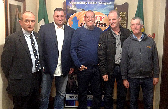
From L-R Commander Cormac Rynne Officer Commanding Shore Operations, Series Producer LS Ron Coveney. LS Alan Cronin, CPO David Hughes, PO James McGrath.

THIS ISLAND NATION broadcasts an extract from the series which begins transmission on CRY 104 FM from Thursday October 22nd at 6.30 p.m., with the second and third parts being broadcast at the same time on October 29 and November 5. The series can also be heard online on www.cry104fm.com produced and presented by Ron Coveney, Leading Seaman in the Naval Service.
The programme also reports the success of Irish lifesavers in winning the top awards in Europe and the huge gift of €8m. which the lifeboat service has received in the form of two historic Ferraris. The reaction of Aran Islanders to winning their battle with the Government over the air service to the islands is also reported.

Published in Island Nation
Tagged under

#EnterDryDockVideo - Afloat.ie has been informed by the Department of Defence that sea-trials of Naval Service latest newbuild OPV90 James Joyce took place between 6-9 March with delivery due shortly, writes Jehan Ashmore.

As originally reported, the trials took place in the Bristol Channel which is accessed from the estuary to where her builder's yard, Babcock Marine & Technology is located in Appledore, Devon. 

After her delivery to the Naval Service, the €54m newbuild is to be commissioned in May. Likewise of her predecessor and delivery of the third and final newbuild in late 2016, the trio will feature drone technology and un-manned mini submarine capability. This will dramatically improve surveillance and incident response times.

As previously reported on Afloat.ie, the dry-docking of LÉ Samuel Beckett (P61) in Cork Dockyard last month was a pre-scheduled period and the date of entering the facility can now be revealed to have begun on 23 February.

According to the Naval Service the dry-docking was standard practice with new vessels to ensure all is well with hull fittings and the ship's capability.

The above video footage only recently published was taken from L.E. Samuel Beckett's bridge-mounted camera view that overlooks the bow of the leadship OPV90 class.

The scene shown is of the OPV departing off the Naval Base's harbour berth on Haubowline Island in lower Cork Harbour. From there she makes the short passage upriver to Cork Dockyard.

As the OPV90 heads closer to Cork Dockyard, Afloat.ie had previously reported of a blue-hulled Russian research vessel among other crafts berthed along the quayside. This vessel was the Geolog Dmitriy Nalivkin of 1,935 tonnes built in 1995 during the Soviet era at a yard in Turku, Finland.

Next we see the LÉ Samuel Beckett (P61) swing into the dry-dock, or graving dock which is 165.5m (539ft) long by 22.5m (73ft) wide and with an access width of 21.3m (70ft).

The dockyard was originally established by James Wheeler in 1853. Currently, Cork Dockyard, is a member of the Burke Shipping Group which is a subsidiary of the Doyle Group.

Published in Navy
The flagship of the Irish Ferries fleet Ulysses celebrates her 10th anniversary on the Dublin-Holyhead port route, writes Jehan Ashmore.
At 50,938 gross tonnes, the cruiseferry which has space for 1,875 passengers and 1,342 vehicles, remains the largest ferry operating on the Irish Sea. Over the decade she has made approximately 14,000 crossings which equates to 826,000 nautical miles on the route linking the Irish capital and Anglesey, north Wales.

In January 2000 the keel of the worlds largest car ferry was laid at the Aker Finnyards in Rauma, Finland. The following year the €100m cruiseferry giant departed the shipyard on a four-day delivery voyage to Dublin Port. Upon Ulysses's arrival on 4th March she was presented with a traditional welcoming escort of saluting water-firing tugs.

The Ulysses was named at a ceremony in the port on 21st March by the 'golden godmother' Mairead Berry, Ireland's 25-year old Paralympic Games gold medallist. Four days later Ulysses made her commercial maiden voyage to Holyhead on 25th March.

Wih 12 decks the vessel has an extensive range of facilities and they are named with themes derived from James Joyce's famous novel 'Ulysses'. There is seating available for up to 1,938 passengers and there are 117 twin or single-cabins, accommodating up to 228 passengers.

Only two months into service the Ulysses won the prestigious 'Most Significant New Build - Ferry' category award in the Cruise & Ferry magazine 2001 Awards competition. Her Finnish builders are not only builders of large cruise-ferries for Baltic Sea operators and beyond but also are also renowned for the construction of very large cruiseships for international clients.

Ulysses was designed specifically to serve the central corridor route with a schedule of two round trips daily. She directly replaced the 1997 Dutch built 34,031 grt ro-pax Isle of Inishmore, which transferred to Rosslare-Pembroke Dock service.

In 2006 the Ulysses alongside her fleetmates were transferred from the Irish flag to the Cypriot flag in addition to a change of Irish crew with those outsourced from citizens mostly from the Baltic and Eastern European countries.

Due to the sheer size of the Ulysses, which has a length of 209m, a beam of nearly 32m and a 6.4m draught, she has not missed a single crossing due to bad weather conditions. The vessel has a 22 knot / 41kph service -speed on the 60-mile route which translates to a distance of over 182,000 kms a year.

To celebrate Ulysses 10th year in service, Irish Ferries has enhanced the Club Class option to passengers which includes free-Wifi, which enables a constant connection and an array of other benefits during the 3-hour 15 minute crossing.

For a virtual tour of the Ulysses with views taken from the top deck as the cruiseferry departs Holyhead and the mountains of Snowdonia setting as a backdrop plus interior tours of the vessel click here.

Published in Ferry
A second drill-rig platform, the Pauline was positioned in Dublin Bay on Friday, to investigate suitable conditions for an outfall discharge pipe from the Ringsend wastewater treatment plant, writes Jehan Ashmore.

The work is part of a Dublin City Council project to evaluate an extension at the Ringsend plant where treated water will be released into the bay. The council are conducting detailed feasibility studies which will be examined for an Environmental Impact Assessment.

To date the project has involved two other rigs, the Aran 250 and the larger Excalibur which remains in the bay. The barges will be towed to 20 pre-determined bore-hole locations in the bay where the jack-up rig barges operate 'legs' to sit on the seabed which enables a steady working platform. The rigs are operating on a continuous basis in an area covering most of Dublin Bay and close to the Burford Bank on the eastern fringes.

In addition a buoy will be positioned 300-metres of the barge during drill operations, which is expected to take approximately one week for each drill. For information on the location of the bore-holes, they can viewed from the Dublin Port website by clicking HERE The project is expected to be completed in late Spring.

Several support craft are engaged in the project that recently included the Seabed Worker, a 3,923 gross tonnes Norwegian anchor-handling tug supply vessel (AHTS) the tugs Multratug 7, MTS Valiant and Trojan and the RIB-craft sisters, Brian Boru and James Joyce which are on standby duties. Like the Trojan, the 12-seater RIBS are based at the Poolbeg Yacht Club Marina where in the tourist season the craft provide excursions in Dublin Bay for Sea Safari Tours. In October the project also required the services of the yellow-hulled catamaran, Xplorer to carry out a bathymetric survey of Dublin Bay. The larger tugs and rigs are based opposite in Alexandra Basin / Ocean Pier.

The largest drill-rig working to date on the project, the Excalibur arrived under the tow of the Multratug 7 on a misty morning on Christmas Day. Due to the weather conditions the red-hulled craft slipped quietly into the port. Several days later the imposing looking craft re-emerged with its six-towering jack-up 'sea-legs' that jutted skywards into an otherwise horizontal expanse of Dublin Bay.

The sight of the rig has presented many onlookers to mistakenly believe the drilling was for oil!...Not so but the assumption is not surprising given the reports last year of an oil-field discovery named the Dalkey Island Prospect. The name for the oil-field was referred to Dalkey, as the coastal suburb on the southern shores is the nearest landfall to the exploratory well sites at the Kish Bank Basin.

In fact this kind of exploratory activity was again to confuse residents throughout the bay when the drill-ship, Fugro Synergy was offshore at the Kish Bank between December 2009 and early Spring of 2010. Though on this occasion the search was not for oil but coal!

During this period the 5,200 tonnes vessel equipped with a drill-tower, seemed to be a near permanent feature on the horizon. A series of drill-wells up to 3,500-metres were conducted when the 2009 built ship was contracted to Irish based VP Power Ltd, to determine the commercial viability of extracting coal from the sea for generating electricity. The Underground Coal Gasification (UCG) project is a process where coal is heated in underwater rock reservoirs to extract gas, essentially converting gas-from-coal energy. Otherwise this method is commonly referred to as a 'clean' technology.

In addition to last year's search for deposits of large coal seams under the seabed, there was reports of a significant natural resource in the form of oil!... when several exploratory blocks again in the Kish Bank Basin were surveyed. The company behind this venture, Provident Resources, another Irish based exploration company, conducted initial oil surveys using air-born craft and as such no actual drill-based ships or rigs were used. Though should any oil flow, such an operation would be required.

Incidentally the Excalibur is designed also to perform offshore wind turbine installation work and is equipped with a 250-ton crane to hoist the wind-farm components. The vessel is operated by Fugro Seacore, a subsidiary of the Dutch parent company, Fugro, which also managed the drill-ship Fugro Synergy.

Published in Dublin Bay
The jack up barge Aran 250 has been positioned in Dublin bay to carry out Borehole Drilling. The work is part of a Dublin City Council (DCC) project relating to the Ringsend Wastewater Treatment Plant. It will involve the use of either the jack-up barge "Aran 250" or "Excalibur".

These jack-up barges will be used for the drilling of test boreholes at various locations within Dublin Bay and its approaches. Initially, the "Aran 250" will be used and it is expected that under normal conditions it will operate on a 24 hour / 7 day week basis.

At all times when the jack-up barge is on location it will transmit an "AIS" signal. By night the barge will display white lights (operated in unison) flashing Morse code (U) every 15 seconds. These will be located at each corner. The barge itself will be lit by operational deck lights.

When the jack-up barge is operational it will have the standby boat "James Joyce" with two people on board in attendance. They will tie-up to a buoy moored approximately 300 metres away from the barge. The small tug "Trojan" will operate as a supply boat and will be based at the Poolbeg Marina. The Trojan will also be used for towing the barge from one location to the next.

The test borehole drilling positions (WGS 84) are as follows :-

M06 Lat 53˚ 19' 53.46'' N Long 006˚ 09' 39.08'' W M15 Lat 53˚ 19' 11.35'' N Long 006˚ 06' 58.16'' W

M07 Lat 53˚ 19' 11.27'' N Long 006˚ 08' 21.42'' W M16 Lat 53˚ 18' 32.75'' N Long 006˚ 06' 33.07'' W

M08 Lat 53˚ 19' 50.64'' N Long 006˚ 06' 21.73'' W M17 Lat 53˚ 20' 23.37'' N Long 006˚ 05' 16.93'' W

M09 Lat 53˚ 18' 38.17'' N Long 006˚ 05' 45.02'' W M18 Lat 53˚ 19' 32.50'' N Long 006˚ 05' 19.69'' W

M10 Lat 53˚ 17' 44.38'' N Long 006˚ 03' 41.33'' W M19 Lat 53˚ 18' 16.91'' N Long 006˚ 05' 02.71'' W

M11 Lat 53˚ 19' 42.31'' N Long 006˚ 03' 22.31'' W M20 Lat 53˚ 17' 51.94'' N Long 006˚ 04' 43.04'' W

M12 Lat 53˚ 19' 00.03'' N Long 006˚ 00' 25.74'' W M21 Lat 53˚ 18' 56.68'' N Long 006˚ 04' 07.12'' W

M13 Lat 53˚ 19' 51.50'' N Long 006˚ 10' 13.42'' W M22 Lat 53˚ 19' 09.75'' N Long 006˚ 02' 37.54'' W

M14 Lat 53˚ 19' 59.29'' N Long 006˚ 07' 53.39'' W M23 Lat 53˚ 18' 48.98'' N Long 005˚ 59' 07.97'' W

Each location will take approximately 1 week to drill. Drilling will not follow in sequence listed above. VTS will keep all shipping advised with regards to the location at which the barge is operating.

More detail is contained in a marine notice issued by Dublin Port Company's
Harbour Master, Captain David T. Dignam HERE

Published in Dublin Bay

General Information on using Waterways Ireland inland navigations

Safety on the Water

All users of the navigations are strongly recommended to make themselves aware of safety on the water for whatever activity they are involved in and to read the advice offered by the various governing bodies and by:

The Dept. of Transport, Ireland: www.gov.ie/transport and The Maritime and Coastguard Agency, UK, The RNLI – Water Safety Ireland for information in terms of drowning prevention and water safety.

Registration of Vessels

All vessels using the Shannon Navigation, which includes the Shannon-Erne Waterways and the Erne System must be registered with Waterways Ireland. Only open undecked boats with an engine of 15 horsepower or less on the Shannon Navigation, and vessels of 10 horsepower or less on the Erne System, are exempt. Registration is free of charge.

Craft registration should be completed online at: https://www.waterwaysireland.org/online-services/craft-registration

Permits for use of the Grand and Royal Canals and the Barrow Navigation

All vessels using the Grand and Royal Canals and the Barrow Navigation must display appropriate valid Permit(s) i.e A Combined Mooring and Passage Permit (€126) and if not intending to move every five days, an Extended Mooring Permit (€152).

Permit applications should be completed online at: https://www.waterwaysireland.org/online-services/canal-permits

Passage on the Royal and Grand Canals – Dublin Area

For boat passage through the locks east of Lock 12 into / out of Dublin on either the Royal or Grand Canals, Masters are requested to contact the Waterways Ireland Eastern Regional Office (M-F 9.30am-4.30pm) on tel: +353(0)1 868 0148 or email [email protected] prior to making passage in order to plan the necessary lock-keeping assistance arrangements.

On the Grand Canal a minimum of two days notice prior to the planned passage should be given, masters should note that with the exception of pre-arranged events, a maximum of 2 boats per day will be taken through the locks, travelling either east or west.

Movements in or out of the city will be organised by prior arrangement to take place as a single movement in one day. Boaters will be facilitated to travel the system if their passage is considered to be safe by Waterways Ireland and they have the valid permit(s) for mooring and passage.

Newcomen Lifting Bridge

On the Royal Canal two weeks’ notice of bridge passage (Newcomen Lifting Bridge) is required for the pre-set lift date, and lock assistance will then also be arranged. A minimum of 2 boats is required for a bridge lift to go ahead.

Waterways Ireland Eastern Regional Office (Tel: +353(0)1 868 0148 or [email protected] ) is the point of contact for the bridge lift.

A maximum number of boats passing will be implemented to keep to the times given above for the planned lifts (16 for the Sat / Sun lifts & 8 for the weekday lifts). Priority will be given on a first come first served basis.

On day of lift, boaters and passengers must follow guidance from Waterways Ireland staff about sequence of passage under bridge & through Lock 1, and must remain within signed and designated areas.

Events Held on the Waterways

All organised events taking place on the waterways must have the prior approval of Waterways Ireland. This is a twelve week process and application forms must be accompanied with the appropriate insurance, signed indemnity and risk assessment. The application should be completed on the Waterways Ireland events page at :

https://www.waterwaysireland.org/online-services/event-approval

Time Limits on Mooring in Public Harbours

On the Shannon Navigation and the Shannon-Erne Waterway craft may berth in public harbours for five consecutive days or a total of seven days in any one month.

On the Erne System, revised Bye Laws state that: No master or owner shall permit a vessel, boat or any floating or sunken object to remain moored at or in the vicinity of any public mooring, including mooring at any other public mooring within 3 kilometres of that location, for more than 3 consecutive days and shall not moor at that same mooring or any other public mooring within 3 kilometres of that location within the following 3 consecutive days without prior permission by an authorised official.

Winter Mooring on the Shannon Navigation and Shannon Erne Waterway

Winter mooring may be availed of by owners during the period 1 Nov to 31 Mar by prior arrangement and payment of a charge of €63.50 per craft. Craft not availing of Winter Mooring must continue to comply with the “5 Day Rule”. Winter Mooring applications should be completed online at : https://www.waterwaysireland.org/online-services/winter-moorings-booking

Owners should be aware that electricity supply and water supply to public moorings is disconnected for the winter months. This is to protect against frost damage, to reduce running costs and to minimise maintenance requirements during the winter months.

Vessel owners are advised that advance purchasing of electricity on the power bollards leading up to the disconnection date should be minimal. Electricity credit existing on the bollards will not be recoverable after the winter decommissioning date. Both services will be reinstated prior to the commencement of the next boating season.

Smart Cards

Waterways Ireland smart cards are used to operate locks on the Shannon Erne Waterway, to access the service blocks, to use the pump-outs along the navigations, to avail of electrical power at Waterways Ireland jetties.

Berthing in Public Harbours

Masters are reminded of the following:

  • Equip their vessel with mooring lines of appropriate length and strength and only secure their craft to mooring bollards and cleats provided for this purpose.
  • Ensure the available berth is suitable to the length of your vessel, do not overhang the mooring especially on finger moorings on floating pontoon moorings.
  • Ensure mooring lines, electric cables and fresh water hoses do not create a trip hazard on public jetties for others users.
  • Carry sufficient fenders to prevent damage to your own vessel, other vessels and WI property.
  • Allow sufficient space between your vessel and the vessel ahead /astern (c.1m) for fire safety purposes and /or to recover somebody from the water.
  • Do not berth more than two vessels side by side and ensure there is safe access/egress at all times between vessels and onto the harbour itself.
  • Do not berth in such a way to prevent use of harbour safety ladders, slipways or pump-outs.
  • Do not allow the bow of your vessel to overhang the walkway of a floating mooring thus creating a hazard for others with an overhanging anchor or bow fendering.
  • Animals are not allowed to be loose or stray at any time.
  • Harbour and jetty infrastructure such as railings, power pedestals, fresh water taps, electric light poles, safety bollards, ladders etc are not designed for the purpose of mooring craft , they will not bear the strain of a vessel and will be damaged.
  • At Carrybridge on the Erne System, Masters of vessels are not permitted to use stern on mooring. Masters of vessels must use the mooring fingers for mooring of vessels and for embarkation / disembarkation from vessels.

Passenger Vessel Berths

Masters of vessels should not berth on passenger vessel berths where it is indicated that an arrival is imminent. Passenger vessels plying the navigations generally only occupy the berths to embark and disembark passengers and rarely remain on the berths for extended periods or overnight.

Lock Lead-in Jetties

Lead-in jetties adjacent to the upstream and downstream gates at lock chambers are solely for the purpose of craft waiting to use the lock and should not be used for long term berthing.

Vessel Wake

Vessel wake, that is, the wave generated by the passage of the boat through the water, can sometimes be large, powerful and destructive depending on the hull shape and engine power of the vessel. This wake can be detrimental to other users of the navigation when it strikes their craft or inundates the shoreline or riverbank. Masters are requested to frequently look behind and check the effect of their wake / wash particularly when passing moored vessels, on entering harbours and approaching jetties and to be aware of people pursuing other activities such as fishing on the riverbank.

Speed Restriction

A vessel or boat shall not be navigated on the Shannon Navigation at a speed in excess of 5 kph when within 200 metres of a bridge, quay, jetty or wharf, when in a harbour or canal or when passing within 100 metres of a moored vessel or boat.

Vessels navigating the Shannon-Erne Waterway should observe the general 5 kph speed limit which applies along the waterway. This is necessary in order to prevent damage to the banks caused by excessive wash from vessels.

Vessels navigating the Erne System should observe the statutory 5kt / 6mph / 10kph speed limit areas.

A craft on the Royal and Grand canals shall not be navigated at a speed in excess of 6km per hour.

A craft on the Barrow Navigation shall not be navigated at a speed in excess of 11km per hour except as necessary for safe navigation in conditions of fast flow.

Bank Erosion

Narrow sections of all the navigations are particularly prone to bank erosion due to the large wash generated by some craft. Masters are requested to be vigilant and to slow down to a speed sufficient to maintain steerage when they observe the wash of their craft inundating the river banks.

Unusual Waterborne Activity

Unusual waterborne vessels may be encountered from time to time, such as, hovercraft or amphibious aircraft / seaplanes. Masters of such craft are reminded to apply the normal “Rule of the Road” when they meet conventional craft on the water and to allow extra room to manoeuvre in the interest of safety.

Sailing Activity

Mariners will encounter large numbers of sailing dinghies from late June to August in the vicinity of Lough Derg, Lough Ree and Lower Lough Erne. Sailing courses are marked by yellow buoys to suit weather conditions on the day. Vessels should proceed at slow speed and with due caution and observe the rules of navigation when passing these fleets, as many of the participants are junior sailors under training.

Rowing

Mariners should expect to meet canoes and vessels under oars on any part of the navigations, but more so in the vicinity of Athlone, Carrick-on-Shannon, Coleraine, Enniskillen and Limerick. Masters are reminded to proceed at slow speed and especially to reduce their wash to a minimum when passing these craft as they can be easily upset and swamped due to their very low freeboard and always be prepared to give way in any given traffic situation.

Canoeing

Canoeing is an adventure sport and participants are strongly recommended to seek the advice of the sport’s governing bodies i.e Canoeing Ireland and the Canoe Association of Northern Ireland, before venturing onto the navigations.

Persons in charge of canoes are reminded of the inherent danger to these craft associated with operating close to weirs, sluice gates, locks and other infrastructure particularly when rivers are in flood and large volumes of water are moving through the navigations due to general flood conditions or very heavy localised precipitation e.g. turbulent and broken water, stopper waves. Shooting weirs is prohibited without prior permission of Waterways Ireland.

Canoeists should check with lockkeepers prior entering a lock to ensure passage is done in a safe manner. Portage is required at all unmanned locks.

Canoe Trail Network – "Blueways"

Masters of powered craft are reminded that a canoe trail network is being developed across all navigations and to expect more organised canoeing along these trails necessitating slow speed and minimum wash when encountering canoeists, rowing boats etc

Rockingham and Drummans Island Canals – Lough Key

It is expected that work on Rockingham and Drummans Island Canals on Lough Key will be completed in 2021. Access to these canals will be for non-powered craft only, eg canoes, kayaks, rowing boats.

Fast Powerboats and Personal Watercraft (Jet Skis)

Masters of Fast Powerboats (speed greater than 17kts) and Personal Watercraft (i.e.Jet Skis) are reminded of the inherent dangers associated with high speed on the water and especially in the confines of small bays and narrow sections of the navigations. Keeping a proper look-out, making early alterations to course and /or reducing speed will avoid conflict with slower vessels using the navigation. Personal Watercraft are not permitted to be used on the canals.

Towing Waterskiers, Wakeboarders, Doughnuts etc

Masters of vessels engaged in any of these activities are reminded of the manoeuvring constraints imposed upon their vessel by the tow and of the added responsibilities that they have to the person(s) being towed. These activities should be conducted in areas which are clear of conflicting traffic. It is highly recommended that a person additional to the master be carried to act as a “look-out” to keep the tow under observation at all times.

Prohibition on Swimming

Swimming in the navigable channel, particularly at bridges, is dangerous and is prohibited due to the risk of being run over by a vessel underway in the navigation.

Age Restrictions on operating of powered craft

In the Republic of Ireland, Statutory Instrument 921 of 2005 provides the legal requirements regarding the minimum age for operating of powered craft. The Statutory Instrument contains the following requirements:

- The master or owner of a personal watercraft or a fast power craft shall take all reasonable steps to ensure that a person who has not attained the age of 16 years does not operate or control the craft

- The master or owner of a pleasure craft powered by an engine with a rating of more than 5 horse power or 3.7 kilowatts shall take all reasonable steps to ensure that a person who has not attained the age of 12 years does not operate or control the craft.

Lifejackets and Personal Flotation Devices (PFDs)

Lifejackets and PFD’s are the single most important items of personal protective equipment to be used on a vessel and should be worn especially when the vessel is being manoeuvred such as entering / departing a lock, anchoring, coming alongside or departing a jetty or quayside.

In the Republic of Ireland, Statutory Instrument 921 of 2005 provides the legal requirements regarding the wearing of Personal Flotation Devices. The Statutory Instrument contains the following requirements:

- The master or owner of a pleasure craft (other than a personal watercraft) shall ensure, that there are, at all times on board the craft, sufficient suitable personal flotation devices for each person on board.

- A person on a pleasure craft (other than a personal watercraft) of less than 7 metres length overall shall wear a suitable personal flotation device while on board an open craft or while on the deck of decked craft, other than when the craft is made fast to the shore or at anchor.

- The master or owner of a pleasure craft (other than a personal watercraft) shall take all reasonable steps to ensure that a person who has not attained the age of 16 years complies with paragraph above.

- The master or owner of a pleasure craft (other than a personal watercraft), shall take all reasonable steps to ensure that a person who has not attained the age of 16 years wears a suitable personal flotation device while on board an open craft or while on the deck of a decked craft other than when it is made fast to the shore or at anchor.

- The master or owner of a pleasure craft (other than a personal watercraft) shall take all reasonable steps to ensure that a person wears a suitable personal flotation device, at all times while – (a) being towed by the craft, (b) on board a vessel or object of any kind which is being towed by the craft.

Further information is available at: http://www.irishstatutebook.ie/eli/2005/si/921/made/en/print

Firing Range Danger Area – Lough Ree

The attention of mariners is drawn to the Irish Defence Forces Firing Range situated in the vicinity of buoys No’s 2 and 3, on Lough Ree on the Shannon Navigation. This range is used regularly for live firing exercises, throughout the year, all boats and vessels should stay clear of the area marked with yellow buoys showing a yellow "X" topmark and displaying the word "Danger".

Shannon Navigation, Portumna Swing Bridge Tolls

No attempt should be made by Masters’ of vessels to pay the bridge toll while making way through the bridge opening. Payment will only be taken by the Collector from Masters when they are secured alongside the jetties north and south of the bridge.

Navigating from Killaloe to Limerick on the Shannon Navigation

The navigation from Killaloe to Limerick involves passage through Ardnacrusha locks, the associated headrace and tailrace and the Abbey River into Limerick City. Careful passage planning is required to undertake this voyage. Considerations include: lock passage at Ardnacrusha, water flow in the navigation, airdraft under bridges on Abbey River in Limerick, state of tide in Limerick

Users are advised to contact the ESB Ardnacrusha hydroelectric power station (00353 (0)87 9970131) 48 hours in advance of commencing their journey to book passage through the locks at Ardnacrusha. It is NOT advised to undertake a voyage if more than one turbine is operating (20MW), due to the increased velocity of flow in the navigation channel, which can be dangerous. To ascertain automatically in real time how many turbines are running, users can phone +353 (0)87 6477229.

For safety reasons the ESB has advised that only powered craft with a capacity in excess of 5 knots are allowed to enter Ardnacrusha Headrace and Tailrace Canals.

Passage through Sarsfield Lock should be booked on +353-87-7972998, on the day prior to travel and it should be noted also that transit is not possible two hours either side of low water.

A Hydrographic survey in 2020 of the navigation channel revealed that the approach from Shannon Bridge to Sarsfield Lock and the Dock area has silted up. Masters of vessels and water users are advised to navigate to the Lock from Shannon bridge on a rising tide one or two hours before High Tide.

Lower Bann Navigation

The attention of all users is drawn to the “Users Code for the Lower Bann”, in particular to that section covering “Flow in the River” outlining the dangers for users both on the banks and in the navigation, associated with high flow rates when the river is in spate. Canoeists should consult and carry a copy of the “Lower Bann Canoe Trail” guide issued by the Canoe Association of Northern Ireland. Users should also contact the DfI Rivers Coleraine, who is responsible for regulating the flow rates on the river, for advisory information on the flow rates to be expected on any given day.

DfI Rivers Coleraine. Tel: 0044 28 7034 2357 Email: [email protected]

Lower Bann Navigation – Newferry – No wake zone

A No Wake Zone exists on the Lower Bann Navigation at Newferry. Masters of vessels are requested to proceed at a slow speed and create no wake while passing the jetties and slipways at Newferry.

Overhead Power Lines (OHPL) and Air draft

All Masters must be aware of the dangers associated with overhead power lines, in particular sailing vessels and workboats with cranes or large air drafts. Voyage planning is a necessity in order to identify the location of overhead lines crossing the navigation.

Overhead power line heights on the River Shannon are maintained at 12.6metres (40 feet) from Normal Summer level for that section of navigation, masters of vessels with a large air draft should proceed with caution and make additional allowances when water levels are high.

If a vessel or its equipment comes into contact with an OHPL the operator should NOT attempt to move the vessel or equipment. The conductor may still be alive or re-energise automatically. Maintain a safe distance and prevent third parties from approaching due to risk of arcing. Contact the emergency services for assistance.

Anglers are also reminded that a minimum ground distance of 30 metres should be maintained from overhead power lines when using a rod and line.

Submarine Cables and Pipes

Masters of vessels are reminded not to anchor their vessels in the vicinity of submarine cables or pipes in case they foul their anchor or damage the cables or pipes. Look to the river banks for signage indicating their presence.

Water Levels - Precautions

Low Water Levels:

When water levels fall below normal summer levels masters should be aware of:

Navigation

To reduce the risk of grounding masters should navigate on or near the centreline of the channel, avoid short cutting in dog-legged channels and navigating too close to navigation markers.

Proceeding at a slow speed will also reduce “squat” effect i.e. where the vessel tends to sit lower in the water as a consequence of higher speed.

Slipways

Reduced slipway length available under the water surface and the possibility of launching trailers dropping off the end of the concrete apron.

More slipway surface susceptible to weed growth requiring care while engaged in launching boats, from slipping and sliding on the slope. Note also that launching vehicles may not be able to get sufficient traction on the slipway once the craft is launched to get up the incline.

Bank Erosion

Very dry riverbanks are more susceptible to erosion from vessel wash.

Lock Share

Maximising on the number of vessels in a lock will ensure that the total volume of water moving downstream is decreased. Lock cycles should be used for vessels travelling each way.

High Water Levels:

When water levels rise above normal summer level masters should be aware of:

Navigation

Navigation marks will have reduced height above the water level or may disappear underwater altogether making the navigable channel difficult to discern.

In narrow sections of the navigations water levels will tend to rise more quickly than in main streams and air draft at bridges will likewise be reduced.

There will also be increased flow rates particularly in the vicinity of navigation infrastructure such as bridges, weirs, locks etc where extra care in manoeuvring vessels will be required.

Harbours and Jetties

Due care is required in harbours and at slipways when levels are at or near the same level as the harbour walkways' as the edge will be difficult to discern especially in reduced light conditions. It is advised that Personal Flotation Devices be worn if tending to craft in a harbour in these conditions.

Slipways

Slipways should only be used for the purpose of launching and recovering of water craft or other objects from the water. Before using a slipway it should be examined to ensure that the surface has sufficient traction/grip for the intended purpose such as launching a craft from a trailer using a vehicle, that there is sufficient depth of water on the slipway to float the craft off the trailer before the concrete apron ends and that the wheels of the trailer do not drop off the edge of the slipway. That life-saving appliances are available in the vicinity, that the vehicle is roadworthy and capable of coping with the weight of the trailer and boat on the incline. It is recommended that slipway operations are conducted by two persons.

Caution to be Used in Reliance upon Aids to Navigation

The aids to navigation depicted on the navigation guides comprise a system of fixed and floating aids to navigation. Prudent mariners will not rely solely on any single aid to navigation, particularly a floating aid to navigation. With respect to buoys, the buoy symbol is used to indicate the approximate position of the buoy body and the ground tackle which secures it to the lake or river bed. The approximate position is used because of the practical limitations in positioning and maintaining buoys in precise geographical locations. These limitations include, but are not limited to, prevailing atmospheric and lake/river conditions, the slope of and the material making up the lake/river bed, the fact that the buoys are moored to varying lengths of chain, and the fact that the buoy body and/or ground tackle positions are not under continuous surveillance. Due to the forces of nature, the position of the buoy body can be expected to shift inside and outside the charted symbol.

Buoys and perches are also moved out of position or pulled over by those mariners who use them to moor up to instead of anchoring. To this end, mariners should always monitor their passage by relating buoy/perch positions with the published navigation guide. Furthermore, a vessel attempting to pass close by always risks collision with a yawing buoy or with the obstruction that the buoy or beacon/perch marks.

Masters of Vessels are requested to use the most up to date Navigation guides when navigating on the Inland Waterways.

Information taken from Special Marine Notice No 1 of 2023