


Displaying items by tag: Harbour
Dun Laoghaire Harbour's 'Stolen' Tricolour Recovered
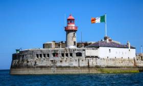
The giant Irish flag 'stolen' from its prominent position on Dun Laoghaire's East pier has been recovered.
The tricolour went missing last night from the flag pole at 7pm.
Afloat.ie sources tell us that it is now back with its rightful owners and the hope is that it will be flying from the pier head again soon.
Bantry Bay Port Launches Primary Schools Initiative
Bantry Bay Port Company has launched its first Schools Initiative for 2016 aimed at 5th class primary schools.
The initiative theme ‘A Day in the Life of a Cruise Passenger Visiting Bantry Harbour’ is aimed at encouraging school children to explore the tourism aspect of Bantry harbour and all the wonderful visitor attractions to see and enjoy in the West Cork region.
Tourism plays a vital role in Bantry Bay Port Company’s business with a number of small cruise liners visiting the harbour each year. These cruise passengers and crew visit West Cork during the summer months, bringing a welcome economic tourism contribution to the region.
All 5th classes who participate in the Bantry Bay Port Company’s initiative will be invited on a boat trip around beautiful Garnish Island, compliments of Bantry Bay Port Company. An award will also be given for ‘Best Artwork Piece’ and each participating class and teacher will receive a Class Certificate of Participation.
Captain Paul O’Regan, Bantry Bay Port Company Harbour Master said: “We are excited to be launching our Bantry Bay Port Company Schools Initiative. The initiative is a great way for primary school children to learn about the history of Bantry port and the role it plays in the region. The theme this year relates to cruise tourism and this is an area Bantry Bay Port Company will be aiming to increase in the coming years.’
He continued: ‘Many local families are involved in tourism either directly or indirectly and so it’s important that children understand tourism and the business it generates for the region. We hope our initiative will make learning fun for the school children.’
Projects must contain a high level of visual content and can contain photographs as well as artwork. The creativity of each project will be taken into account when being judged as well as visual impact, originality, content and presentation. Bantry Bay Port Company will provide each participating school with a piece of ply-wood 2ft x 2ft and this must be used for the project. Closing date for submissions is Friday 6th May 2016. All submitted projects will go on public display in Bantry during the summer months.
To register your primary school or for further information, please visit the Bantry Bay Port Company website
€18m in Fishery Harbour Works Announced
Pontoons in Cape Clear, West Cork a small craft harbour in Killybegs, County Donegal and dredging works in Howth, County Dublin are part of an €18m Capital Investment Package in 2016 for the development of Ireland’s fishery harbour network announced today by Minister for Agriculture, Food and the Marine, Simon Coveney T.D. See the full table below.
Announcing the investment package, the Minister said “In total I am allocating €18m for this year's Fishery Harbour and Coastal Infrastructure Capital Programme. I have set aside €16m towards safety, maintenance and new development works at the six Fishery Harbour Centres at Howth, Dunmore East, Castletownbere, Dingle, Rossaveel and Killybegs. I am also making €2m available for a Local Authority Harbour Programme, and I am assessing specifically what is required to address storm damage at Local Authority owned fishery harbours.”
Flagship projects in the 2016 Capital Programme (see table1) include the provision of dedicated Ferry pontoons on the West Pier in Howth, infrastructure upgrades in Dunmore East, commencement of the Dinish Wharf expansion Project in Castletownbere, expansion of the small craft harbour in Ros an Mhíl and the Smooth Point pier extension in Killybegs. The Minister continued, “While there are a number of flagship projects for completion this year, of equal importance is the preparatory work for significant potential projects in Howth, Dunmore East, An Daingean and Ros an Mhíl”
The 2016 Fishery Harbour and Coastal Infrastructure Capital Programme outlined by the Minister also contains funding of €2m to assist coastal Local Authorities repair, maintain and develop piers, harbours and slipways under their ownership. The Minister stated “I am delighted to continue to support Local Authorities in their efforts to maintain and develop the fishery harbour network which provides much needed facilities for our rural fishing and marine focussed communities. A number of smaller fishing piers around the coast experienced some damage during the recent storms and we are currently assessing how best to assist Local Authorities in carrying out repairs”
Concluding on the 2016 Fishery Harbour and Coastal Infrastructure Capital Programme, the Minister said “This year’s programme is significant on a number of fronts, firstly it provides for the continuation of this Governments strategy to develop and improve the facilities at our fishery harbours in 2016. Secondly it prepares the groundwork for potential projects in the coming years all of which will benefit the fishing industry, seafood processing sector, other ancillary marine industries.”
Table 1- Fishery Harbour & Coastal Infrastructure Development Programme 2016
| Location | Project | Cost €m |
|
Howth: |
- Traffic Management Works - East Pier Repairs - Pontoons to west pier for ferry landings - Engineers office - Preparation of Dumping at Sea licence - Provision of Berthing Face to Middle Pier - Electric Works West Pier - Gas Main - Other Services (Sewers,ducting,watermains) Total |
0.150 0.050 0.400 0.050 0.100 0.100 0.300 0.150 0.150 1.450 |
|
Dunmore East: |
- Harbour Office Upgrade - West Wharf upgrade - Breakwater (Design Report) - Harbour Road re-surface Total |
0.700 0.200 0.160 0.100 1.160 |
| Castletownbere: |
- Harbour User toilet and Shower facilities - Dinish Wharf Expansion - Harbour Slipway - Quayside Electrical Upgrade - Harbour Offices Upgrade - Replacement of water network Dinish - Dinish Bridge Survey - CCTV Total |
0.090 1.000 0.040 0.150 0.250 0. 450 0.080 0.070 2.130 |
|
An Daingean:
|
- Workshop Design ,Planning and commence works - Capital Dredging Navigation Channel – Dumping at sea Licence, tender preparation and preparation works - Net mending area Total |
0.400 0.500 0.100 1.000 |
|
Ros an Mhíl:
|
- Quay Development – Design, Evaluations, Consulting, EIS, Permitting and preparation works - Small craft Harbour – Dredging Total |
0.800 1.800 2.600 |
|
Killybegs:
|
- Repairs to Blackrock/Auction Hall Piers - Small Craft Harbour - Smooth Point Pier Development - Landing Pier Fendering - Landing Pier Electrical Design/Works - Boatyard investment Total |
0.175 0.900 2.500 0.300 0.190 0.0 70 4.135 |
|
Cape Clear
|
-Pontoons Total |
400 0.400 |
| Total Departmental Owned Marine Infrastructure projects | €12.875 | |
| Safety and Maintenance and Non-Discretionary and Contractual Capital Commitments 2016 (incl Disability Access) | €3.120 | |
| Total Local Authority Harbour Development and Marine Leisure | €2.000 | |
| Total Fishery Harbour and Coastal Infrastructure Capital Programme |
€17.995
|
|
President Higgns Signs Harbours Bill into Law, Regional Ports Transfer to Local Authorities
President Higgins signed the Harbours Bill into law on Christmas Day, the first time a President has signed legislation in to law on that day.
The Harbours bill provides the necessary legal framework for the transfer of certain ports in Dun Laoghaire, Drogheda, Galway, New Ross, and Wicklow to local authorities.
President Higgins also signed four other Bills on Christmas Day such is the haste at which the government is signing legislation before next year's General Election, according to Michael O'Regan in today's Irish Times here.
Read also: Regional Ports Move to Local Authorities in 'Radical Overhaul' of Port Sector

#dharbour – RESPONSE TO PUBLIC COMMENTARY ARISING FROM STAKEHOLDER/PUBLIC CONSULTATION EXERCISE HELD IN MARCH/APRIL 2015 CRUISE BERTH PROJECT AT DUN LAOGHAIRE HARBOUR For DUN LAOGHAIRE HARBOUR COMPANY ON BEHALF OF THE DUN LAOGHAIRE CRUISE STAKEHOLDER GROUP
The Dun Laoghaire Cruise Stakeholder Group has responded to concerns raised in a number of submissions made as part of an informal pre-planning consultation process in connection with the proposed development of a new cruise berth facility in Dún Laoghaire Harbour.
It is expected that a formal planning application for the proposed development will be submitted to An Board Pleanala in the coming weeks.
As part of the consultation process the Cruise Stakeholder Group met and briefed local public representatives and stakeholder groups. Full details of the proposal were posted on the Dún Laoghaire Harbour Company website and all those on the company's database were written to. Posters were also erected in the harbour area inviting members of the public to submit their views.
A total of 139 submissions were received. The submissions offered a variety of views, including positive support for the project. A large number of submissions expressed some concerns, and indeed opposition to the project. In some cases opposition / concern was based on a misunderstanding of what was actually proposed or had misplaced concerns about the implications for harbour users.
The Dún Laoghaire Cruise Stakeholder Group is committed to taking into account all submissions made before the planning application to An Bord Pleanála is finalised.
However, in order to address concerns that were raised, the Stakeholder Group has now published a short document summarising the main issues which arose during the informal pre-planning consultation process, along with a succinct response to each issue. A summary of the issues and responses will also available on the Harbour Company's website. This document is now being issued to all those who made submissions, to public representatives and to stakeholder groups. [Scroll down to read this document]
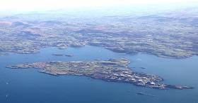
The Dun Laoghaire Harbour Masterplan, published in 2011, identified the need to develop strategies to ensure the long term future of the harbour, in view of the declining importance of ferry traffic. Development of cruise business was identified as one of the opportunities to be pursued. In addition, Dún Laoghaire is designated as a marine tourism port under the Government's National Ports Policy and the development of the cruise business fits into this framework.
Dún Laoghaire will have its most successful cruise season ever in 2015, with 100,000 passengers and crew expected. However the development of the cruise berth facility is essential to allowing up to build on the success to date and to bring even more vessels and passengers to our town.
The expansion and development of the cruise business offers significant economic benefits to Dún Laoghaire and the surrounding areas. These would include expenditure by disembarked passenger and crew; payments to tour operators by cruise companies and purchases by cruise ships from local supplies while in harbour.
The Dún Laoghaire Cruise Stakeholder Group is confident that the cruise berth development can be delivered while preserving the unique heritage of the harbour and without impacting unduly on sailing and marine leisure activities which are such significant parts of the harbour's activities.
Introduction
The Dun Laoghaire Harbour Company on behalf of the Dun Laoghaire Stakeholder Group in the process of compiling a planning application to be submitted to An Bord Pleanala under the Strategic Infrastructure (SID) provisions of the Planning & Development Act 2000, as
amended.
As part of that process it was decided to canvass the views of local people prior to making the planning application in order to seek to accommodate or ameliorate any issues that may arise as part of the application. This was referred to as a 'Phase 1 Consultation'.
The undertaking of this exercise and any involvement in same would not affect people's rights to participate in the planning application process in the normal way.
Phase 1 Consultation
A presentation was prepared in order to provide an over view of the project in terms of what it involves (both during construction and operation), the work undertaken to date and an explanation of the application process that would follow.
A set of Frequently Asked Questions (FAQ's) and responses was prepared in anticipation of the typical queries that would arise.
A page on the Harbour Company web site was set up which included the above presentation, together with accompanying maps of the harbour, along with the FAQ's. This information was available for download.
It was intended to have a two week period in which members of the public could make their views known. The Harbour Company used its database of stakeholders to send a letter inviting participation in this Public Consultation phase. In addition, posters were erected around the Harbour so that Harbour Users would see the consultation was on-going and could participate.
Prior to commencing this Consultation, meetings were arranged with key stakeholders/Harbour Users. These meetings took place in the last week of March 2015.
Overall, the Stakeholder/ public consultation process occurred over a three week period. There have also been a series of meetings both with Dun Laoghaire Rathdown County Council and An Bord Pleanala relating to this project. Those consultations occurred separately to this public consultation process.
Who did we meet?
The following is a schedule of the meetings held prior to the Public Consultation process
commencing:-
Monday, 23rd March:
• Dun Laoghaire Area Committee, Dun Laoghaire Rathdown County Council
Tuesday, 24th March:
• St Michael's Rowing Club
• Sea Scouts/ Kyron O'Gorman
• Irish National Sailing School
• Dun Laoghaire Motor Yacht Club
• Royal National Lifeboat Institution (RNLI)
Wednesday, 25th March:
• Coal Harbour Users Group
• Marina Company
• Dun Laoghaire Business Investment District Company
• Commissioners of Irish Lights
Thursday, 26th March:
• National Yacht Club
• Dublin Bay Sailing Club
Friday, 27th March:
• Royal Saint George Yacht Club
• Royal Irish Yacht Club
Wednesday 1st May 2015
• The Water Wags
Number of responses
In total 139 responses were received during this Phase 1 Consultation phase. Of these, 13 were in favour of the project, 22 made observations or raised queries and the remainder were against, with a variety of issues raised.
In general only a minority of submissions were supportive, some simply raised questions of made broad comment, but the majority expressed opposition to the proposal; in some cases these were based upon a misunderstanding of what was in fact proposed, or misplaced about the implications for harbour users.
What were the issues raised?
In seeking to provide a response at this stage, we have attempted to group common issues under particular headings. This avoids too much repetition in the responses provided below.
From a review of the Submissions made, the following issues arose:-
1. Impact on dingy sailing/youth sailing
2. The cruise berth cuts the harbour in two.
3. Impact on sailing competitions in the harbour
4. Impact on ability to attract International sailing competitions
5. "Wind shadow" effect of cruise ship in harbour
6. Impact on Heritage of the harbour
7. Suitability (or otherwise) for a Victorian harbour
8. Potential for environmental damage and negative impact on bird and marine life
9. Safety/emergency incident plan
10. Rocky nature of harbour bed making dredging difficult
11. Disturbance to mercury in the harbour bed caused by dredging
12. No economic benefit to the town
13. Impact on traffic
14. Legal advice that project is not Strategic Infrastructure Development
15. Too little detail provided about the scheme
16. Consultation period too short
17. Replacement ferry service for Stena
18. Leave cruise business to Dublin Port.
19. Continue with existing cruise tendering operation (ships anchoring in Dublin Bay)
20. DLHC should not be allowed embark on a new venture like this, while a merger with DLRCoCo is pending
Dinghy sailing/youth sailing
It is evident from a review of the comments received that the issue which arose the most often was the impact the proposal would have on Dinghy Sailing/Youth Sailing. In particular, the following activities were raised:-
• Junior Summer Sailing Courses
• Sailability Dun Laoghaire
• Friday Night Racing
• September Series
• Regional and National Optimist Class Championships
• Junior Sailing Regatta's
• ISA National and Regional squad clinics
• Team Racing
• Winter Frostbite Racing
• Summer Tuesday Night Racing
• Winter Coaching
• Dun Laoghaire Regatta
We will have regard to the aspects associated with each of these within the planning application.
Preliminary response to issues
The issues raised through the public consultation exercise will be addressed in a full and comprehensive way as part of the plans and particulars to be lodged with An Bord Pleanala.
At the outset, it is worth recalling that Dun Laoghaire Harbour is first and foremost a working harbour. It also happens to accommodate a marine leisure component which it is recognised and acknowledged contributes to its charm and character. It is also recognized that the marine leisure component of the harbour is a significant part of the harbour activity. This marine leisure activity must and does function in a manner that does not detract from the primary function of the harbour.
To that end, it is worth highlighting that activities within the Harbour are carefully managed and controlled in line with long established rules, referred to as the Notices to Mariners and the Harbour Bye-Laws.
With that in mind, the following provides an initial response to the principal issues raised by members of the public and harbour users generally.
1 Impact on dingy sailing/youth sailing
At present, most harbour users ultilise the harbour as a transit zone between the shore and the bay, where the vast majority of sailing activities occur. This occurs in line with the normal restrictions applying within the Harbour. It is acknowledged that traditionally junior training has taken place in the harbour. All such activity requires the approval of the Harbour Master.
The Notice to Mariners No. 4 defines the Training Area for junior sail training. It states:- "Harbour Recreational Area for Small Craft is the triangular area of the North Bightwestwards of a line from West Pier Lighthouse to the marina west breakwater". Use of the remainder of the harbour by small craft is otherwise restricted, unless and until 'permission' has been obtained. With the removal of swing moorings in 2014, the North Bight area available for raining has been considerably enlarged which has benefitted junior training in the harbour. This will be unaffected by the proposed cruise project
Notwithstanding the Notice to Mariners No. 4, it is recognized that the very junior sailors/beginners associated with the NYC and RSGYC have utilized the sheltered water space immediately around the Carlisle Pier and St. Michael's Pier to learn to sail. Both the IYSC and the INSS use the designated training area at the North Bight.
When competent, the junior training regime then moves from around the piers, to the formal training area and then out to the bay. The INSS use both the Coal Harbour and Seapoint Beach, as well as using the designated training area.
The tradition over the past 15 years or so has been that the more senior/experienced juniors use Dublin Bay itself to train.
It is Dublin Bay that is the 'Major Area of Excellence for Sailing' and the sailing areas that are available now will be available after any cruise berth project has been installed. The designated training area in the North Bight has recently (2014) been extended and will continue to be available.
It has been suggested in a number of submissions that the provision of the cruise berth will prevent the harbour being used for sailing and other marine activity. This argument does not stand up to closer scrutiny. Whilst it is fully acknowledged that the facility will result in some change to the existing patterns of activities for some users, others will see little or no change.
Traditionally, there has been very little 'racing' inside the harbour, other than by the Water Wags, DBSC and the DMYC Winter Series and this has been 'by permission' only.
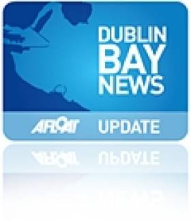
2 The cruise berth will cut the harbour in two The cruise berth will extend northwards from the existing marina breakwater, from a location to the west of the existing HSS berth.
Even though the berth structures are significant, to allow the berth to accommodate the type of large cruise ship that the cruise lines now favour, there will be a considerable expanse of water within the harbour, north of the northernmost extremity of the proposed berth, which will allow unimpeded travel for boats between the eastern and western areas of the harbour. The total distance from the marina breakwater to the West Pier roundhead is about 0.66 kilometers (660m). The berth will extend northwards for just under two thirds of this distance, leaving just over one third remaining for cross harbour activity.
In addition to the above, the proposed berth will include an underpass which will allow passage between the marina and the areas to the east of the harbour without the need to go around the berth. This underpass will be suitable for use by ribs, launches and other small non-masted craft.
3 Impact on sailing competitions in the harbour There are in fact only a very small number of sailing competitions in the harbour and these occur at particular times of the year only.
As previously noted, all activities within the harbour are subject to an approval process. It is considered that with the adjustments made to the swing moorings at the East and North Bights in recent years that it should be possible for these limited competitions to continue to use the harbour. The Harbour Company is committed to working with the race organisers to find a viable solution within the Harbour.
4 Impact on ability to attract international sailing competitions At the outset we would comment that when international sailing competitions have occurred in Dun Laoghaire in the past, this has imposed severe restrictions on other harbour users.
Appropriate restrictions and safeguards were put in place by the Harbour Master and harbour users adjusted their activities accordingly with little or no fuss for those periods. As regards the loss of such competitions due to the cruise berth project being implemented, it is respectfully submitted that this would not be the case. The continued use of the harbour as a transit zone and holding area as occurred with such events in the past could continue to occur when the cruise berth is in place.
5 Wind shadow effect of cruise ship in harbour Large cruise ships at berth will have an effect on the wind patterns locally, and will result in "wind shadow" downwind of the ship.
The affected area will vary depending on a number of factors, including the size of the ship, the direction of the wind and the speed of the wind. No matter what direction the wind is blowing, there will always an area of the harbour that will be windward of ships at berth and therefore unaffected. This unaffected area of the harbour will always be available for dinghy/youth sailing. It will also be possible to sail in the area affected by "wind shadow" on the leeward (sheltered) side of the ship, with the exception possibly of up close to the ship. Winds blowing roughly parallel to the ship will have little or no "wind shadow" effect. Experienced sailors are familiar with the "wind shadow" effect as their sails create "wind shadow" and a knowledge of this effect is used to gain competitive advantage in racing by manoeuvring to put their competitors in the bad wind caused by the "wind shadow" of their boats.
6 Impact on heritage of the harbour
The development being proposed does not impact on any protected structures, nor does it involve the removal of any heritage structures. The proposal involves the provision of a new berth within an existing harbour and is entirely appropriate as a result. It is acknowledged that part of the Harbour's heritage is its use for marine recreational purposes. This aspect of the Harbour use will not be destroyed by the cruise berth.
7 Suitability of proposal for a Victorian Harbour
There have been quite a number of changes to the activities that occur within the harbour since the days it was first built. The harbour has evolved many times as a result. As already highlighted, it is a working harbour. It is a simple fact that it costs a significant
amount of money annually to just maintain the quality and infrastructure of the harbour. Much of the harbour is old and needs on-going maintenance. The Harbour Company is self financing and needs to generate the required income to sustain the harbour in to the future. For clarity, the Harbour Company receives no funding from Government. The cruise berth is precisely the type of facility one would expect to find in a harbour. With the impending demise of the HSS (which has now occurred), the Harbour Company is looking to attract cruise ships to the harbour. The berth will go some way towards ensuring the viability of the harbour in to the future.
8 Potential for environmental damage and negative impact on bird and marine life This particular issue has been extensively assessed as part of the Environmental Impact Statement being finalized at present.
The preparation of this assessment involved extensive discussions with the National Parks and Wildlife Service, including the Marine Department in Galway and has been conducted by a firm of specialist ecologists. We have been concerned from the outset to minimize any impact the proposal might have on birds or marine life generally and have devised a construction methodology specifically intended to address this.
9 Safety/Emergency Incident Plan
As a working harbour, we can confirm that Dun Laoghaire Harbour has an Emergency Management Plan in place at present in line with the tenets of "A Framework for Major Emergency Management". The current Emergency Plan can be adjusted to take account of the cruise berth facility. The Plan already caters for cruise ship tendering. A Risk Assessment and SOP are in operation for present cruise visits and will be adapted for berth usage.
10 Rocky nature of harbour bed making dredging difficult
As part of the preparatory investigation and survey work undertaken for the project, a programme of ground investigation work was undertaken which included the drilling of boreholes into the seabed in the areas where the proposed berth would be constructed and in the areas to be dredged. It was found that rock was generally located well below the existing seabed and the proposed dredge level. It is therefore not envisaged that any rock or hard material will need to be dredged for the project. This is consistent with the findings of previous investigations in this area of the harbour.
11 Disturbance to mercury in the harbour bed caused by dredging
The area which will require dredging has been the subject of extensive ground investigations as part of the scheme design and Environmental Impact Statement process relating to the project. No elevated levels of mercury have been identified We are aware that mercury has historically been found in other parts of the Harbour near the Coal Harbour. No dredging or marine works are planned for the Coal Harbour as part of this project and as a result no disturbance to the ground conditions will arise.
12 No economic benefit to the town
The Stakeholder Group has commissioned a firm of economic consultants to look in to the economic impacts of the project. Their findings show that there is the very real potential for the town to benefit directly and significantly from the arrival of cruise visits to Dun Laoghaire.
It is estimated that the net economic impact of doing the project for Dun Laoghaire town will lie between €16m and €41m after twenty years, depending on the number of vessels coming into Dublin Bay. The lower number assumes a continuation of historical growth trends in the Dublin Bay market, while the upper limit represents a replication of the success of Copenhagen.
It is recognized that the businesses of the town need to embrace the potential for additional revenue arising from the visiting cruise passengers for this process to be a success. The Cruise Stakeholder Group are confident that Dun Laoghaire will maximize this potential in the years to come.
13 Impact on traffic
The traffic associated with the planned cruise project has been assessed as part of the Environmental Impact Statement process. This shows that the surrounding roads and streets are capable of catering for the traffic associated with the project with relative ease. The project will involve a modest number of coach trips at particular peak periods in the day.
Previously when the HSS was operating five sailings per day (arriving and departing), there was significantly more traffic movements in the area of the project.
It is also worth recalling that there was no particular traffic difficulties with the cruise visits to Dun Laoghaire last year and again when the Royal Princess visited Dun Laoghaire on the 12th May 2015 (3,600 passengers and 1,350 crew). Overall, we are confident that the traffic associated with the cruise project can be catered for
on the existing road network with minimal disturbance.
14 Legal advice that project is not Strategic Infrastructure Development
The project contains a new cruise berth that is greater than 100m in length capable of catering for the new generation of cruise vessels. The Seventh Schedule of the Planning & Development Act 2000, as amended includes a project involving a new berth in a harbour of 100m or more in length as being a project for which the provisions known as strategic infrastructure applies. In line with the requirements of the Act a dialogue with An Bord Pleanala to determine whether the project is or is not strategic infrastructure was commenced in May 2013. An Bord Pleanala have now confirmed in writing that the project is strategic infrastructure and have directed the planning application to be made to An Bord Pleanala directly.
15 Too little detail provided about the scheme
We would respectfully suggest that a significant amount of detail regarding the project was provided at pre-consultation and as part of the consultation. The final project design is nearing completion, as is the EIS that is intended to accompany the application. The outcome of this pre-application public consultation will feed in to the final plans. The full and final detail of the scheme will be available for interested members of the public on a dedicated web site and will also be available at the offices of Dun Laoghaire-Rathdown County Council during the seven week consultation period after the planning application is lodged with An Bord Pleanala. The application will also be available in the offices of An Bord Pleanala.
16 Consultation period too short
The stakeholder/public consultation period took place over a three week period. This was considered adequate to obtain the views of people towards the project. It was made clear in the material provided at this stage of the process that a further much lengthier and formal process of consultation would follow once the planning application for the project was lodged.
The response to the request for comments generated 139 submissions. There will be a full seven week consultation period once the planning application is lodged, during which time observations to An Bord Pleanala may be made. This will afford interested parties with a further opportunity to comment on the final proposals.
17 Replacement ferry service for Stena HSS
We can confirm that the Harbour Company is in discussion with potential ferry operators. Were a ferry service to return to Dun Laoghaire, it would only be a small craft service catering for small numbers of cars and foot passengers. It is not envisaged that by the operators that vessels capable of accommodating freight traffic will come to Dun Laoghaire again. Such a small craft ferry could operate in the harbour in tandem with a cruise berth facility.
18 Leave cruise business to Dublin Port
The National Ports Policy (2013) identifies Dun Laoghaire Harbour as follows:- the long-term future of Dún Laoghaire Harbour Company will be in terms of marine leisure, maritime tourism, cultural amenity and urban redevelopment. The cruise industry will have a major part to play in the realization of these national policy
aspirations for the harbour. It is considered entirely consistent with National Ports Policy to encourage cruise visits to Dun Laoghaire Harbour. It is considered that there is scope for both Dun Laoghaire Harbour and Dublin Port to cater for the increasing cruise industry in Dublin Bay.
19 Continue with existing cruise tendering operation (ships anchoring in the Bay)
Cruise lines will always favour direct berthing to tendering, as it offers a better experience for its passengers and is more reliable. Tender berthing requires a long transit from ships anchored a couple of kilometres outside the harbour in small tender boats. The transit time to and from the ship means that the time available for passengers ashore is shorter than would be the case if the cruise ship were able to berth within the harbour. It is also subject to weather conditions, as conditions may be such that the journey in the tenders is uncomfortable due wind and wave conditions, or indeed, weather conditions are such that it is deemed unsafe for passengers to disembark from the cruise ship onto the tenders, so the visit to Dun Laoghaire is cancelled. A smaller proportion of the passengers and crew on board the cruise ships will come ashore if the ships tender in Dublin Bay than if the ships berth in the harbour and passengers can disembark onto a quay. The provision of a direct berth will attract a greater number of cruise ships, and a greater proportion of passengers aboard those ships will come ashore to explore Dun Laoghaire and its surroundings, as it is easier to come ashore and to get back onto the ship, providing a greater benefit to Dun Laoghaire and
the greater Dublin area.
20 DLHC should not be allowed embark on a new venture like this, while a merger with DLRCoCo is pending
The project promoter is the Dun Laoghaire Cruise Stakeholder Group. The three principal members of this Group are; Dun Laoghaire Harbour Company, Dun Laoghaire-Rathdown County Council and the Dun Laoghaire BID Company.
The planning application is being made with the approval and assistance of Dun Laoghaire- Rathdown County Council which approved the initial expenditure at a Council Meeting in July 2013. Officials from Dun Laoghaire-Rathdown County Council have attended the majority of the project meetings held with An Bord Pleanala and have expressed their support in principle for the project.
#dlharbour –Three French naval training ships will pay a courtesy visit to Dun Laoghaire Harbour in May. The Harbour Master of Dun Laoghaire Harbour Company, Simon Coate, accepted the invitation from the French Ministry of Defence for the ships to visit.
The 'Lion', 'Leopard' and 'Eglantine' will be in Dun Laoghaire from Friday 1st - Monday 4th May as part of a training excursion, the aim of which is to teach French navy students how to sail a ship. Coastal and ocean navigation and manoeuvre teaching will be taught during the training. Each ship is fully equipped with lecture and training rooms as well as specific teaching equipment. During the training excursions, the ships are also employed by the French Ministry of Defence for the watch and guard of French maritime approaches, and all ships have the ability to release counter-oil products, used for counter pollution missions.
Speaking in advance of the arrival of the naval ships, CEO of the Dun Laoghaire Harbour Company, Gerry Dunne, said: "We're delighted to welcome the three French naval training ships to Dun Laoghaire. This year will be an extremely busy one for the Harbour, with over 20 cruise calls taking place this summer. The visit of the naval ships offers a nice start to this season and they should act as an interesting sight for local ship enthusiasts. We're also looking forward to welcoming the French naval students to the town."
#dlharbour – Dún Laoghaire BID (Business Improvement District) company is hailing plans for a next-generation cruise berth as a game-changer for the area's economy.
The Dún Laoghaire Cruise Stakeholder Group (composed of the BID company, Dún Laoghaire Harbour Company and Dún Laoghaire Rathdown Co. Council) says the new cruise berth will provide a €27 million boost to the area and hinterlands and will lead to significant jobs growth but local yacht clubs have voiced concerns over the plan.
The Stakeholder Group has the long-term aim of emulating the Copenhagen model of welcoming 800,000 cruise visitors to Dublin per annum, with at least 50% of these coming to Dún Laoghaire. This will create new employment both at construction phase and develop employment and growth in the tourism industry in Dún Laoghaire and surrounding areas.
The expansion and development of the cruise business would offer significant economic benefits to Dún Laoghaire and the surrounding areas. These would include expenditure by disembarked passenger and crew; payments to excursion operators by cruise companies; harbour fees; and purchases by cruise ships of local supplies while in harbour.
The increased cruise passenger numbers will also contribute to significant additional domestic footfall in the town and harbour areas. It is expected that for every cruise passenger, at least one Irish resident will be attracted to the Harbour to look at the ships. This potential 400,000 increase in footfall will also add vibrancy to the area and represents economic opportunities for local businesses.
The BID company, which represents Dún Laoghaire's 800 plus businesses, says the new 390-metre berth will position Dún Laoghaire as leaders in marine and leisure tourism in Ireland and will transform the fortunes of business with the creation of new jobs in the area.
The proposed new berth at Dún Laoghaire Harbour will be one of just two in Ireland that can accommodate cruise ships up to 340m in length. At present Cobh is the only port in Ireland that can accommodate these vessels.
The Dún Laoghaire Cruise Stakeholder Group developed the plans for the establishment of the new cruise berth facility. The Stakeholder Group welcomed the first cruise call to the Harbour in 2012 with 300 passengers and crew arriving that year. This snowballed and in 2013 30,000 cruise passengers arrived in Dún Laoghaire. This figure will treble this year with the arrival of 100,000 cruise passengers and crew to the Harbour.
Over 50% of new ships currently on order are over 300m in length. Cruise ships want to be able to dock and allow passengers to disembark directly on to a quay, rather than being taken ashore by tender.
Chairman of the Dún Laoghaire BID company, Don McManus says the new cruise berth will be a game changer for the economy in Dún Laoghaire and surrounding areas:
"Dún Laoghaire is designated as a marine tourism port under the Government's National Ports Policy, and the development of the new cruise berth will be fundamental to establishing the entire area as a leading marine and leisure destination."
"The expansion and development of the cruise business will offer significant economic benefits to Dún Laoghaire and the surrounding areas. These include expenditure by disembarked passenger and crew; payments to excursion operators by cruise companies; harbour fees; and purchases by cruise ships of local supplies while in harbour.
The planning application for the new facility is set to be submitted to An Bord Pleanala by the end of April.
– DL Harbour Company Press Release
Dun Laoghaire Harbour Masterplan Shortlisted for Prestigious Award for Planning Excellence

#dlmasterplan – Dun Laoghaire Harbour Masterplan has been shortlisted in the 'Excellence in Planning to Create Economically Successful Places' category at the 2015 Planning Awards for Excellence. The Awards, run by the Royal Town Planning Institute (RTPI) will be held at the Pullman London St Pancras Monday, 6th July 2015.
The Dun Laoghaire Harbour Masterplan was published in 2011 following extensive consultation with harbour stakeholders. The plan seeks to extend the recreational and amenity value of the harbour; to promote investment; and to generate sufficient revenue from commercial operations to ensure the sustainability of the maintenance programme and marine facility that the harbour provides. In short, the objective is to transform the harbour into a living, vibrant area, offering facilities for people to live, work and relax. The Masterplan envisages development over a 15 - 20 year period. It will be reviewed every five years.
Gerry Dunne, the CEO of Dun Laoghaire Harbour Company said today: "I am delighted that our Masterplan has been nominated for such a prestigious award. A huge amount of work was put into the drafting of the Masterplan which aims to transform the harbour into a living, vibrant area for people to live work and relax, while at the same time preserving the unique character that has made the harbour such an amenity over decades.
"The nomination comes at a time when we are in the midst of a public consultation process on one of the key proposals in the Masterplan – the development of a new cruise ship berth facility, to enable the harbour to cater for new, larger cruise ships. This will be a great boost for all those who want to see Dun Laoghaire Harbour thrive", Mr. Dunne said
The RTPI represents 23,000 planning professionals worldwide and promotes spatial planning, shapes policy and raises professional standards. The Awards for Planning Excellence have been run by the RTPI for over 30 years to recognise planning excellence.
This year's headline sponsor is AECOM with other sponsors and supporters including Bilfinger GVA, The Planner, Planning Aid England and the Royal Borough of Kensington and Chelsea.
Janet Askew, President of the Royal Town Planning Institute said: "The shortlist reflects the very best planning projects, strategies and processes that are helping to make great places for people to live and work. The 80 finalists highlight exceptional examples of planning that have made an impact and brought considerable benefits. It will be a tremendous challenge picking individual category winners from such a high quality field."
Andrew Jones, Practice Leader for Design, Planning + Economics, EMEA at AECOM said:
"AECOM is proud to be this year's headline sponsor of the RTPI's Awards for Planning Excellence. The shortlist is a diverse mixture of outstanding examples of planning, which really demonstrate the impact the profession has on quality and delivery in the built environment. We look forward to seeing which entries the judges select as the category winners."
Projects on the shortlist have been recognised for their national contribution to planning and demonstrate how significant schemes can be delivered speedily through the planning and other consents systems.
#sdls – A new group, Save Dun Laoghaire Sailing (SDLS), has come forward with radical proposals for a re-configuration of the harbour in order to accommodate the proposed Cruise Liner Berth in the harbour, (plans of which were revealed on Afloat.ie last Thursday), while at the same time maintaining the town's pre-eminent role as Ireland's greatest sailing centre.
A spokesperson for SDLS said that the new group's proposals were still only at a very preliminary stage, but the extremely short time lapse permitted for objections or modifications to the Harbour Company's plan has meant that they have had to act in great haste.
However, the spokesperson asserted that the harbour's thousands of recreational sailors are so concerned at some elements of the new plan - such as the rumoured intention to forbid boats manoeuvring under sail only, let alone racing, within the harbour – that they have had no trouble in recruiting supporters, and an ad hoc inaugural meeting in recent days instructed an acting committee to proceed as rapidly as possible.
The underlying thinking behind SDLS's proposals is that the areas of activity for the different interests within the harbour should be clearly delineated. "Good fences make good neighbours" is the group's core philosophy, and with this in mind they have proposed two new in-harbour breakwaters in order that the large area in the centre of the harbour, which is intended for use by the new cruise liner berthing facilities, will be walled off from other areas of the port.
This will be done by a new in-harbour breakwater from St Michael's Pier to the outer end of the present East Pier, and another small in-harbour breakwater closing off the present outer entrance to the marina.
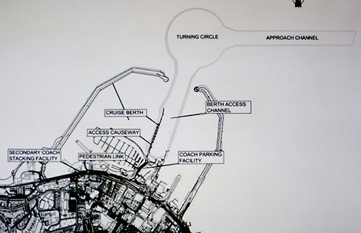
Dun Laoghaire Harbour with the Harbour Company's proposed Cruise Liner Berth occupying most of the space between St Michael's Pier and the harbour entrance
Radical proposals from SDLS (Save Dun Laoghaire Sailing) include new Eastern and Western entrances to the harbour, and two new in-harbour breakwaters which will clearly separate the cruise liner areas from the recreational sailing and boating areas. In effect, three new harbours will be created.
In order to make this feasible, the group has come up with the visionary concept of giving Dun Laoghaire Harbour two additional entrances. The new entrance to the east would be created by making a gap in the existing East Pier, and would inevitably be expensive, as this is exposed to onshore winds, and thus would require a very substantial sheltering breakwater. However, it would still be as cost-effective as possible, as this new Eastern Entrance would not need to be nearly as wide as the current main entrance, as that was created in order to be negotiated by the cumbersome sailing ships of the early 19th Century.
When Afloat.ie pointed out to the spokesperson (who wishes to remain anonymous for the time being) that a gap in the East Pier would result in the ending of the time-honoured tradition of South Dubliners walking the length of the pier on a Sunday, the response was that the demographic is such that an increasing number of South Dubliners are so aged as to be no longer capable of walking the entire length of the East Pier, and thus they would welcome the shorter walk to the lighthouse which will be provided by the new inner breakwater direct from St Michael's Pier.
A further question about the need for manoeuvring space for the cruise liners between their proposed berth and the East Pier elicited the reply that the Harbour Company have already made it clear that they will have to dredge a ten metre channel from the present main entrance to the new berth to serve the deeper drafted liners. Therefore the building of a new pier along the eastern edge of this dredged channel will not impinge on the cruise liners' area of access, and will moreover restrain small craft which might be sailing or racing in the eastern harbour from straying into the liner area.
SDLS is particularly enthused about the possibilities offered by he new western entrance. "For far too long, the West Pier has been more like the Wild West Pier than part of a civilised harbour," we were told. Now, with the new entrance, it will be brought centre stage, and those dinghy sailors from the RIYC, the DMYC, the INSS and the Coal Harbour who were formerly reluctant to venture into the open waters of Dublin Bay will find they have easy access to the relatively sheltered Bay waters between the West Pier and Seapoint.
SDLS conclude their initial policy document by pointing out that their plan would in effect provide the benefit of having three harbours where at present only one exists. And for further diversity, they suggest that the central commercial area for the cruise liners could possibly, in time, also accommodate some working fishing boats, as the colourful activity of hardy fisherfolk is much appreciated by cruise liner passengers
As to the fact that the creation of two new entrances means in effect that there will now be two completely separate leisure harbours on the south side of Dublin Bay with their entrances one and a half miles apart, SDLS argues that this is one of the most attractive features of their plan.
"Sailing enthusiasts from places blessed with natural advantages and numerous little ports of call, such as Cork Harbour, are always bemoaning the fact that when you sail out of Dun Laoghaire, there is nowhere convenient to go to within easy reach. But thanks to our plan, we can now envisage that a boat which has to go to sea via the new West Entrance could go out for a nice sail in Dublin Bay, and then go visiting in the eastern part of the harbour through the new Eastern Entrance, and vice versa.
Having considered these attractive options, we don't see the proposed new cruise liner berth as a problem. On the contrary, we see it as an opportunity to make Dun Laoghaire a much more interesting place to sail from".
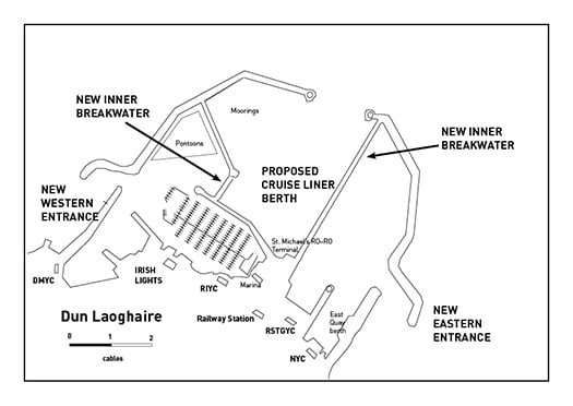
Dun Laoghaire harbour largely as it is today, although the presence of the HSS ferry in port is now history and the contentious new library has been inserted in the tree-surrounded green space at right foreground. Photo courtesy ICC.
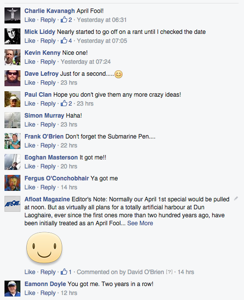
Editor's Note: Normally our April 1st special would be pulled at noon. But as virtually all plans for a totally artificial harbour at Dun Laoghaire, ever since the first ones more than two hundred years ago, have been initially treated as an April Fool joke, we think we'll let this one run. And further comments are welcome, for underlying the tomfoolery, a very serious situation is developing for the harbour's future.
The Minister for Agriculture, Food and the Marine, Simon Coveney TD, today announced the full details of a €17.8m Capital Investment Package for the ongoing development of Ireland's publicly owned fishery harbours and local harbour network .
In announcing the initiative the Minister said "I am delighted to announce the full details of my Departments €17.8m Fishery Harbour and Coastal Infrastructure Capital Programme for 2015. I have set aside €14.9m towards safety, maintenance and new development works at the six Fishery Harbour Centres at Howth, Dunmore East, Castletownbere, Dingle, Rossaveel and Killybegs, in addition to the completion of infrastructural improvement and storm damage repair works at North Harbour, Cape Clear which is also owned by my Department."
Flagship projects in the 2015 Capital Programme (see table1) include major dredging works at Dunmore East, the provision of small craft harbours and pontoons in Howth, Rossaveal and Killybegs, electrical upgrading in Castletownbere, and necessary remedial works to the main pier in Dingle. In addition, the Bull Nose Development and the Duffy's Pier storm damage repair projects at North Harbour Cape Clear are to be completed.
The Minister went on to say "I have also allocated €1.5m for a Local Authority Harbour Development and Marine Leisure programme in 2015, and as an exceptional measure I am also providing in the region of €1.4m to facilitate the completion of a number of Local Authority Storm Damage projects which were approved in 2014 as part of the Governments response to the extreme weather conditions in late 2013 and early 2014, but not completed by the Local Authorities in 2014 due to time constraints and other issues. My Department will be contacting the Local authorities regarding these schemes shortly."
The Minister concluded by saying "This is a significant level of investment in Ireland's publicly owned fisheries and local harbour network. It will continue the implementation of the Governments strategy to develop and improve the facilities at our Fishery Harbour Centres and other public harbours around our coast, benefitting a broad cohort of stakeholders including the fishing industry, seafood processing sector, other ancillary marine industries, marine tourism and leisure and the wider rural coastal communities".
Table 1- Fishery Harbour & Coastal Infrastructure Development Programme 2015
|
Location |
Project |
Department Approved Funding |
|
|
Cape Clear, Co. Cork. |
Bull Nose Development |
€900,000 |
|
|
Duffy’s Pier |
€900,000 |
||
|
Safety & Maintenance Works |
€50,000 |
||
|
Disability Access Works |
€10,000 |
||
|
Piers, Lights & Beacons |
€136,000 |
||
|
All Fishery Harbour Centres |
Safety and Maintenance |
€1,440,000 |
|
|
Howth FHC |
Traffic Management Works |
€75,000 |
|
|
Provision of Small Craft Pontoon |
€1,000,000 |
||
|
Site investigation for West Pier pontoon and Middle Pier upgrade |
€150,000 |
||
|
Upgrading Electrical System – Phase 3 |
€150,000 |
||
|
Castletownbere FHC |
Power points & Electrical Upgrade |
€350,000 |
|
|
Sanitary Facilities Works |
€90,000 |
||
|
Harbour Slipway – Phase 1 |
€400,000 |
||
|
Replacement of Water Network – Dinish Island- design |
€20,000 |
||
|
Proposed Development South Side – Dinish Island- site investigation |
€30,000 |
||
|
An Daingean FHC |
Navigation Buoys Replacement |
€130,000 |
|
|
Main Pier sheet pile Remedial Works |
€200,000 |
||
|
Harbour Workshop and Marina Users Facilities Building - Design |
€40,000 |
||
|
Upgrade Harbour Entrance |
€150,000 |
||
|
Rossaveel FHC |
Phase 2 Small Craft Harbour |
€700,000 |
|
|
Construction of New Slipway – Design Phase |
€70,000 |
||
|
Dunmore East FHC |
Harbour Office Upgrade – Phase 2 |
€200,000 |
|
|
Breakwater design |
€150,000 |
||
|
Traffic Management Plan |
€15,000 |
||
|
Dredging Works |
€6,500,000 |
||
|
Killybegs FHC |
Improvement works to Shipyard Entrances |
€40,000 |
|
|
Small Craft Harbour – Phase 2 |
€700,000 |
||
|
Provision of additional bollards |
€60,000 |
||
|
Smooth Point Pier Extension – studies and preparation: |
€175,000 |
||
|
Power Outlets - Boatyard |
€40,000 |
||
|
Local Authority |
Local Authority Harbour Development and Marine Leisure |
€1,500,000 |
|
|
Local Authority Storm Damage |
€1,400,000 |
||


 as lead helm, rounds the Fastnet Rock on the way to the overall win in 1987")
