Menu

Ireland's sailing, boating & maritime magazine

Inland afloat headers


Displaying items by tag: Doolin Pier

#TicketIssue - Later this week a High Court judge will decide if he should ban the sale of ferry-ride tickets from a new portable building office at Doolin Harbour, despite the fact they can be sold lawfully from a folding table right beside it.

The Irish Examiner writes that James Connolly, for Clare County Council, told Mr Justice David Keane the provision on the pier of an “unauthorised ultra-cabin structure” was a matter of great concern which was protecting the public interest through the planning regulations.

Mr Connolly said selling tickets from a folding table in the open air, did not require planning permission as did the use of the ultra cabin, purportedly a replacement for an old, unoccupied, derelict and long unused structure on the Doolin pier at Ballaghaline.

The county council seeks an injunction immediately restraining ticket sales from the new cabin and, ultimately at a full trial, will seek its removal.

For much more the newspaper has a report here.
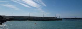
Published in Ferry

The new Doolin Pier development has won the prestigious Irish Concrete Society Award for Infrastructural Projects delivered during 2015.

The award was presented this week to Clare County Council, the contractor L & M Keating Ltd; consulting engineers Punch Consulting, Malachy Walsh & Partners and the main material suppliers for the €6m project, namely Banagher Precast Concrete, Cairealacht Chill-Bhride Teo, Ryan Bros. (Ennis) and McGrath's Quarry.

Among the other shortlisted projects which competed for the Infrastructure Award were the Corrib Tunnel Infill in Co Mayo, the Cloghran AIS Substation in Dublin, Dublin Airport Concrete Apron, Carrigtwohill Wastewater Treatment Plant in Cork and Bridge Projects in Donegal, Sligo and Tyrone.

In its citation for Doolin Pier, the Jury in the 2016 Irish Concrete Society award scheme stated, "This exposed maritime site provided a significant challenge in constructability and in complying with environmental constraints. Concrete is an obvious choice for this structure in this exposed location, combining strength and durability. The innovative step was to use precast construction techniques to construct large fully interlocking sections off site. This reduced the on-site construction time, limiting difficult working conditions and allowing better quality control for the elements which were to be submerged or below the high water line. The overall quality of finish of the in-situ above water deck and wave wall is good, and precast concrete was also very successfully used for wave dissipating x-blocs."

The new pier was officially opened in June 2015 in the North Clare coastal village where currently an estimated 70,000 to 90,000 passengers are carried to and from the Aran Islands by Doolin-based ferry operators and this is expanding annually with the introduction of the Wild Atlantic Way.

Meanwhile, Clare County Council this week announced the appointment of consultants for the design of proposed shoreline facilities at the pier, including a new visitor facility.

The Council says the proposed visitor facility will replace existing temporary structures and will be part of a masterplan proposal relating to the development of the Doolin Pier area including the pier area in general, its interactivity with Doolin village with a significant emphasis on accessibility, parking and traffic management.

The architect-led design team comprises Bucholz McEvoy Architects (Architects), Punch Consulting Engineers (Civil Structural Engineers), IN2 Engineering (M&E Engineers), Aecom (Quantity Surveyor), Aegis Safety Ltd (PSDP safety) and HRA Planning (Planning).

Published in Coastal Notes
Tagged under

#doolinpier – The new €6m Pier at Doolin, Co. Clare, has been officially opened today by Brendan Howlin, T.D., Minister for Public Expenditure & Public Reform.

The new 65-metre pier, the development of which was led by Clare County Council, will serve as a primary access point to and from the Aran Islands for ferry companies operating out of Doolin.

"This important infrastructure project has been long sought after by ferry operators, fishermen and tourists who use the pier. The new pier development will boost visitor numbers in Clare considering access to the Aran Islands from the County has now been greatly enhanced with the completion of this project," said Cllr. John Crowe, Cathaoirleach of Clare County Council.

"I want to congratulate the staff of Clare County Council and the consulting engineers on the project, Punch Consultant Engineers and Malachy Walsh & Partners, who have guided the pier project through the various stages of planning and construction. I also want to acknowledge L & M Keating Limited of Kilmihil who completed the construction of the new pier on schedule and within budget," he added.

Tom Coughlan, Chief Executive, Clare County Council commented: "From the outset, the Council has believed this project would have significant, positive economic and social consequences for the people of North Clare and the wider region, including the Doolin Coast Guard, fishermen, tourists and the general public in terms of leisure and amenity use. This belief has been strengthened over the years as a result of the support shown by the local community, the Elected Members and of course, the Government."

Mr. Coughlan said the completion of the new pier complements plans to develop a Visitor Services facility at the location.

"The next step in the development of Doolin Pier will be the planning and construction of ferry terminal visitor facilities, incorporating improvements to parking and ancillary services. That project is currently being progressed and I look forward to further announcements in the near future," added Mr. Coughlan.

Published in Coastal Notes
Tagged under

#doolin – Clare County Council has announced plans to develop a Visitor Services facility at Doolin Pier as part of an overall masterplan for the development of shoreline facilities in the County Clare coastal village.

The Council says the proposed facility will replace existing temporary structures and will be part of a masterplan relating to the development of the Doolin Pier area including the pier area in general, vehicle routes to and from Doolin village, and parking and traffic management.

Among the functions and operations considered within the overall plan will be sale of tickets by a number of Ferry Operators, the serving of food, and the provision of toilet facilities for patrons and staff, public waiting area, luggage holding area, tourism information, car/bike parking, waste management, harbour master office and health & safety requirements.

A new €6m pier is currently under construction and is nearing completion, according to the Council. The project is on target for completion by mid-2015. An estimated 70,000 to 90,000 passengers are carried annually by Doolin-based ferry operators.

"I welcome the steps being taken by Clare County Council to develop a visitor facility at Doolin which has been long sought after by users of the pier," stated Cllr. John Crowe, Cathaoirleach of Clare County Council.

"Once completed this summer, I have no doubt that the pier will help to drive ferry activity between North Clare and the Aran Islands and the Cliffs of Moher during the tourist season, as well as accommodate other activities – both leisure based and otherwise. It is important that such significant transport infrastructure is complemented by important ancillary services and facilities as proposed in this masterplan," said Cllr. Crowe.

Clare County Council is presently undertaking a tender process to appoint a Design consultancy team to design the masterplan for the Doolin Pier area.

"Doolin Pier is a gateway to the Aran Islands and is a major economic location in the North Clare area. The investment in the new pier will increase visitor numbers to the North Clare area and it is important therefore, that the necessary services are in place to accommodate this growth," Tom Coughlan, Chief Executive, Clare County Council.

Mr. Coughlan noted that the Visitor Services facility is the priority element of the brief, to be delivered initially as a "sustainable standalone project" capable of future integration within the overall masterplan.

"As part of the service provision by the successfully appointed design team, a full design brief will be developed through design research and via a consultation process. It is anticipated that the new development will enhance visitor numbers to Doolin and the Aran Islands by facilitating easier and more ordered parking, ticket sales and pier operations. This is all part of the Council's major commitment to providing improved infrastructure and services at Doolin Pier," said Mr. Coughlan.

Published in Coastal Notes
Tagged under

#DoolinPier – A new Atlantic seaboard pier sought by ferry operators and fishermen at Doolin in County Clare is expected to be completed by mid-2015 following the signing of a major marine infrastructural project today.

Brendan Howlin, T.D., Minister for Public Expenditure and Reform was in Doolin this afternoon to visit the location of the proposed €6m pier project for the County Clare coastal village.

Minister Howlin's visit coincided with the signing by Clare County Council of a contract with L&M Keating, the successful tenderer for the construction of the new pier. Construction work will begin in the coming days and is expected to be completed by mid-2015.

Mayor of Clare Cllr. Joe Arkins commented: "This project has been long sought after by ferry operators, fishermen and tourists who use the pier. The new pier development will boost visitor numbers in Clare considering access to the Aran Islands from the County will be greatly enhanced once the project is completed."

He added: "The completed pier will be used mainly to facilitate ferry activity between North Clare and the Aran Islands and the Cliffs of Moher during the tourist season while the existing pier will be available to accommodate other activities – both leisure based and otherwise. The new pier will ensure that Doolin is accessible in all tidal conditions, which will be of particular benefit to Doolin Search and Rescue as well as the ferry operators."

"I want to congratulate Clare County Council and its consultants who have worked closely with interested parties in ensuring that the completed pier brings a wide range of benefits to its users and the wider community," said Mayor Arkins.

Tom Coughlan, Clare County Manager added: "I am delighted that construction of this vitally important piece of infrastructure will commence shortly following years of open debate and extensive consultation with users of the pier, as well as the local community."

He continued: "The Local Authority has invested considerable time and resources into ensuring that the Doolin Pier project is one that benefits all users of the existing pier. Once completed, this project will have significant, positive economic and social consequences for the people of North Clare and the wider region. For example, the construction phase of the project will create jobs as will the increase in business that will arise as a result of the Pier's completion."

Tom Tiernan, Senior Engineer and Doolin Pier Project Manager stated: "I wish to pay tribute to the Council Consultants, led initially by Malachy Walsh and Partners, who guided the project from its inception through the various stages of planning, including the preparation of the Environmental Impact Statement (EIS) which facilitated An Bord Pleanala's decision in 2013 to give the go ahead for the construction of a new pier. I also want to thank Punch Consulting, who are leading the project through its tender and construction stages."

"The next stage of the Pier project is construction which will get underway almost immediately. L & M Keating Ltd, with whom Clare County Council signed a contract with today, is a well established Marine Works contractor and we look forward to working with the company. We anticipate that the project will be completed around mid 2015," concluded Mr. Tiernan.

Published in Coastal Notes
Tagged under

#doolinpier –  Clare County Council today (Wednesday, 6 March 2013) welcomed the announcement by An Bord Pleanala of its decision to give the go ahead for the construction of a new pier in the North Clare coastal village of Doolin.

The Council said it has reviewed the terms of the Bord's decision and will be meeting the project consultants with a view to commencing the tendering process in the near future.

Reacting to today's announcement, Mayor of Clare Councillor Pat Daly said: "I am delighted that the green light has finally been given for this vitally important piece of infrastructure following years of open debate and discussion on what the best way forward should be. I wish to compliment Clare County Council and its officials for facilitating the process and ensuring that everyone's voice was heard. The Pier will bring increasing numbers of people to County Clare considering access to the Aran Islands from the County will be greatly enhanced once the project is completed."

Tom Coughlan, Clare County Manager said An Bord Pleanala's decision today was "the result of a comprehensive proposal submitted by the Council and extensive consultation with users of the pier as well as the local community."

He continued: "Clare County Council has invested considerable time and resources into ensuring that the Doolin Pier project is one that benefits all users of the existing pier. Once completed, this project will have significant, positive economic and social consequences for the people of North Clare and the wider region. For example, the construction phase of the project will create jobs as will the increase in business that will arise as a result of the Pier's completion."

Tom Tiernan, Senior Engineer and Doolin Pier Project Manager commented: "I wish to pay tribute to the Council Consultants, led by Malachy Walsh and Partners, who have guided the project from its inception through the various stages of planning, including the preparation of the Environmental Impact Statement (EIS) which ultimately facilitated An Bord Pleanala's decision today."

"He added: "The provision of this new pier will have a hugely positive impact on the operations of Ferry operators, fishermen and the local search and rescue unit, who have been finding it increasingly difficult to launch their boats at low water levels."

"The next stage of the Pier project is construction. We will shortly be meeting with the project consultants with a view to getting a tender process underway as soon as possible. We anticipate that the project will be completed during early 2015," concluded Mr. Tiernan.

Published in Coastal Notes
Tagged under
The capsized Rolex Fastnet Race entrant Rambler 100 was not the only vessel that got into difficulties yesterday as an Aran Islands ferry became stranded off Doolin Pier, according to a report in today's Irish Times.
Rose of Aran, a passenger ferry operated by Aran Doolin Ferries stranded on rocks for three hours, just metres off Doolin Pier when making an approach at 11.30 am to collect passengers travelling to the islands. The ferry was between Crab Island and Doolin pier when it ran aground about 25m from the shore.

According to ferry operator Kevin O'Brien, there were no passengers on board at the time and the vessel got under way again when it was lifted from the rocks with the tide. Mr O'Brien added "this was a very minor incident and there was no damage to the ferry. Doolin is tidal so these things do happen. Even a few inches of water can make a difference".

The Irish Coast Guard was notified of the incident at midday, and its marine rescue co-ordination centre in Dublin requested that members of the local Coast Guard unit board the vessel to assess if there was a pollution risk.

Doolin Coast Guard personnel carried out an inspection and confirmed the ferry had not been damaged and there was no risk of pollution. At about 2.15pm the ferry got under way again with the tide. The company was able to operate services to and from the Aran Islands with its second vessel.

Published in Ferry

General Information on using Waterways Ireland inland navigations

Safety on the Water

All users of the navigations are strongly recommended to make themselves aware of safety on the water for whatever activity they are involved in and to read the advice offered by the various governing bodies and by:

The Dept. of Transport, Ireland: www.gov.ie/transport and The Maritime and Coastguard Agency, UK, The RNLI – Water Safety Ireland for information in terms of drowning prevention and water safety.

Registration of Vessels

All vessels using the Shannon Navigation, which includes the Shannon-Erne Waterways and the Erne System must be registered with Waterways Ireland. Only open undecked boats with an engine of 15 horsepower or less on the Shannon Navigation, and vessels of 10 horsepower or less on the Erne System, are exempt. Registration is free of charge.

Craft registration should be completed online at: https://www.waterwaysireland.org/online-services/craft-registration

Permits for use of the Grand and Royal Canals and the Barrow Navigation

All vessels using the Grand and Royal Canals and the Barrow Navigation must display appropriate valid Permit(s) i.e A Combined Mooring and Passage Permit (€126) and if not intending to move every five days, an Extended Mooring Permit (€152).

Permit applications should be completed online at: https://www.waterwaysireland.org/online-services/canal-permits

Passage on the Royal and Grand Canals – Dublin Area

For boat passage through the locks east of Lock 12 into / out of Dublin on either the Royal or Grand Canals, Masters are requested to contact the Waterways Ireland Eastern Regional Office (M-F 9.30am-4.30pm) on tel: +353(0)1 868 0148 or email [email protected] prior to making passage in order to plan the necessary lock-keeping assistance arrangements.

On the Grand Canal a minimum of two days notice prior to the planned passage should be given, masters should note that with the exception of pre-arranged events, a maximum of 2 boats per day will be taken through the locks, travelling either east or west.

Movements in or out of the city will be organised by prior arrangement to take place as a single movement in one day. Boaters will be facilitated to travel the system if their passage is considered to be safe by Waterways Ireland and they have the valid permit(s) for mooring and passage.

Newcomen Lifting Bridge

On the Royal Canal two weeks’ notice of bridge passage (Newcomen Lifting Bridge) is required for the pre-set lift date, and lock assistance will then also be arranged. A minimum of 2 boats is required for a bridge lift to go ahead.

Waterways Ireland Eastern Regional Office (Tel: +353(0)1 868 0148 or [email protected] ) is the point of contact for the bridge lift.

A maximum number of boats passing will be implemented to keep to the times given above for the planned lifts (16 for the Sat / Sun lifts & 8 for the weekday lifts). Priority will be given on a first come first served basis.

On day of lift, boaters and passengers must follow guidance from Waterways Ireland staff about sequence of passage under bridge & through Lock 1, and must remain within signed and designated areas.

Events Held on the Waterways

All organised events taking place on the waterways must have the prior approval of Waterways Ireland. This is a twelve week process and application forms must be accompanied with the appropriate insurance, signed indemnity and risk assessment. The application should be completed on the Waterways Ireland events page at :

https://www.waterwaysireland.org/online-services/event-approval

Time Limits on Mooring in Public Harbours

On the Shannon Navigation and the Shannon-Erne Waterway craft may berth in public harbours for five consecutive days or a total of seven days in any one month.

On the Erne System, revised Bye Laws state that: No master or owner shall permit a vessel, boat or any floating or sunken object to remain moored at or in the vicinity of any public mooring, including mooring at any other public mooring within 3 kilometres of that location, for more than 3 consecutive days and shall not moor at that same mooring or any other public mooring within 3 kilometres of that location within the following 3 consecutive days without prior permission by an authorised official.

Winter Mooring on the Shannon Navigation and Shannon Erne Waterway

Winter mooring may be availed of by owners during the period 1 Nov to 31 Mar by prior arrangement and payment of a charge of €63.50 per craft. Craft not availing of Winter Mooring must continue to comply with the “5 Day Rule”. Winter Mooring applications should be completed online at : https://www.waterwaysireland.org/online-services/winter-moorings-booking

Owners should be aware that electricity supply and water supply to public moorings is disconnected for the winter months. This is to protect against frost damage, to reduce running costs and to minimise maintenance requirements during the winter months.

Vessel owners are advised that advance purchasing of electricity on the power bollards leading up to the disconnection date should be minimal. Electricity credit existing on the bollards will not be recoverable after the winter decommissioning date. Both services will be reinstated prior to the commencement of the next boating season.

Smart Cards

Waterways Ireland smart cards are used to operate locks on the Shannon Erne Waterway, to access the service blocks, to use the pump-outs along the navigations, to avail of electrical power at Waterways Ireland jetties.

Berthing in Public Harbours

Masters are reminded of the following:

  • Equip their vessel with mooring lines of appropriate length and strength and only secure their craft to mooring bollards and cleats provided for this purpose.
  • Ensure the available berth is suitable to the length of your vessel, do not overhang the mooring especially on finger moorings on floating pontoon moorings.
  • Ensure mooring lines, electric cables and fresh water hoses do not create a trip hazard on public jetties for others users.
  • Carry sufficient fenders to prevent damage to your own vessel, other vessels and WI property.
  • Allow sufficient space between your vessel and the vessel ahead /astern (c.1m) for fire safety purposes and /or to recover somebody from the water.
  • Do not berth more than two vessels side by side and ensure there is safe access/egress at all times between vessels and onto the harbour itself.
  • Do not berth in such a way to prevent use of harbour safety ladders, slipways or pump-outs.
  • Do not allow the bow of your vessel to overhang the walkway of a floating mooring thus creating a hazard for others with an overhanging anchor or bow fendering.
  • Animals are not allowed to be loose or stray at any time.
  • Harbour and jetty infrastructure such as railings, power pedestals, fresh water taps, electric light poles, safety bollards, ladders etc are not designed for the purpose of mooring craft , they will not bear the strain of a vessel and will be damaged.
  • At Carrybridge on the Erne System, Masters of vessels are not permitted to use stern on mooring. Masters of vessels must use the mooring fingers for mooring of vessels and for embarkation / disembarkation from vessels.

Passenger Vessel Berths

Masters of vessels should not berth on passenger vessel berths where it is indicated that an arrival is imminent. Passenger vessels plying the navigations generally only occupy the berths to embark and disembark passengers and rarely remain on the berths for extended periods or overnight.

Lock Lead-in Jetties

Lead-in jetties adjacent to the upstream and downstream gates at lock chambers are solely for the purpose of craft waiting to use the lock and should not be used for long term berthing.

Vessel Wake

Vessel wake, that is, the wave generated by the passage of the boat through the water, can sometimes be large, powerful and destructive depending on the hull shape and engine power of the vessel. This wake can be detrimental to other users of the navigation when it strikes their craft or inundates the shoreline or riverbank. Masters are requested to frequently look behind and check the effect of their wake / wash particularly when passing moored vessels, on entering harbours and approaching jetties and to be aware of people pursuing other activities such as fishing on the riverbank.

Speed Restriction

A vessel or boat shall not be navigated on the Shannon Navigation at a speed in excess of 5 kph when within 200 metres of a bridge, quay, jetty or wharf, when in a harbour or canal or when passing within 100 metres of a moored vessel or boat.

Vessels navigating the Shannon-Erne Waterway should observe the general 5 kph speed limit which applies along the waterway. This is necessary in order to prevent damage to the banks caused by excessive wash from vessels.

Vessels navigating the Erne System should observe the statutory 5kt / 6mph / 10kph speed limit areas.

A craft on the Royal and Grand canals shall not be navigated at a speed in excess of 6km per hour.

A craft on the Barrow Navigation shall not be navigated at a speed in excess of 11km per hour except as necessary for safe navigation in conditions of fast flow.

Bank Erosion

Narrow sections of all the navigations are particularly prone to bank erosion due to the large wash generated by some craft. Masters are requested to be vigilant and to slow down to a speed sufficient to maintain steerage when they observe the wash of their craft inundating the river banks.

Unusual Waterborne Activity

Unusual waterborne vessels may be encountered from time to time, such as, hovercraft or amphibious aircraft / seaplanes. Masters of such craft are reminded to apply the normal “Rule of the Road” when they meet conventional craft on the water and to allow extra room to manoeuvre in the interest of safety.

Sailing Activity

Mariners will encounter large numbers of sailing dinghies from late June to August in the vicinity of Lough Derg, Lough Ree and Lower Lough Erne. Sailing courses are marked by yellow buoys to suit weather conditions on the day. Vessels should proceed at slow speed and with due caution and observe the rules of navigation when passing these fleets, as many of the participants are junior sailors under training.

Rowing

Mariners should expect to meet canoes and vessels under oars on any part of the navigations, but more so in the vicinity of Athlone, Carrick-on-Shannon, Coleraine, Enniskillen and Limerick. Masters are reminded to proceed at slow speed and especially to reduce their wash to a minimum when passing these craft as they can be easily upset and swamped due to their very low freeboard and always be prepared to give way in any given traffic situation.

Canoeing

Canoeing is an adventure sport and participants are strongly recommended to seek the advice of the sport’s governing bodies i.e Canoeing Ireland and the Canoe Association of Northern Ireland, before venturing onto the navigations.

Persons in charge of canoes are reminded of the inherent danger to these craft associated with operating close to weirs, sluice gates, locks and other infrastructure particularly when rivers are in flood and large volumes of water are moving through the navigations due to general flood conditions or very heavy localised precipitation e.g. turbulent and broken water, stopper waves. Shooting weirs is prohibited without prior permission of Waterways Ireland.

Canoeists should check with lockkeepers prior entering a lock to ensure passage is done in a safe manner. Portage is required at all unmanned locks.

Canoe Trail Network – "Blueways"

Masters of powered craft are reminded that a canoe trail network is being developed across all navigations and to expect more organised canoeing along these trails necessitating slow speed and minimum wash when encountering canoeists, rowing boats etc

Rockingham and Drummans Island Canals – Lough Key

It is expected that work on Rockingham and Drummans Island Canals on Lough Key will be completed in 2021. Access to these canals will be for non-powered craft only, eg canoes, kayaks, rowing boats.

Fast Powerboats and Personal Watercraft (Jet Skis)

Masters of Fast Powerboats (speed greater than 17kts) and Personal Watercraft (i.e.Jet Skis) are reminded of the inherent dangers associated with high speed on the water and especially in the confines of small bays and narrow sections of the navigations. Keeping a proper look-out, making early alterations to course and /or reducing speed will avoid conflict with slower vessels using the navigation. Personal Watercraft are not permitted to be used on the canals.

Towing Waterskiers, Wakeboarders, Doughnuts etc

Masters of vessels engaged in any of these activities are reminded of the manoeuvring constraints imposed upon their vessel by the tow and of the added responsibilities that they have to the person(s) being towed. These activities should be conducted in areas which are clear of conflicting traffic. It is highly recommended that a person additional to the master be carried to act as a “look-out” to keep the tow under observation at all times.

Prohibition on Swimming

Swimming in the navigable channel, particularly at bridges, is dangerous and is prohibited due to the risk of being run over by a vessel underway in the navigation.

Age Restrictions on operating of powered craft

In the Republic of Ireland, Statutory Instrument 921 of 2005 provides the legal requirements regarding the minimum age for operating of powered craft. The Statutory Instrument contains the following requirements:

- The master or owner of a personal watercraft or a fast power craft shall take all reasonable steps to ensure that a person who has not attained the age of 16 years does not operate or control the craft

- The master or owner of a pleasure craft powered by an engine with a rating of more than 5 horse power or 3.7 kilowatts shall take all reasonable steps to ensure that a person who has not attained the age of 12 years does not operate or control the craft.

Lifejackets and Personal Flotation Devices (PFDs)

Lifejackets and PFD’s are the single most important items of personal protective equipment to be used on a vessel and should be worn especially when the vessel is being manoeuvred such as entering / departing a lock, anchoring, coming alongside or departing a jetty or quayside.

In the Republic of Ireland, Statutory Instrument 921 of 2005 provides the legal requirements regarding the wearing of Personal Flotation Devices. The Statutory Instrument contains the following requirements:

- The master or owner of a pleasure craft (other than a personal watercraft) shall ensure, that there are, at all times on board the craft, sufficient suitable personal flotation devices for each person on board.

- A person on a pleasure craft (other than a personal watercraft) of less than 7 metres length overall shall wear a suitable personal flotation device while on board an open craft or while on the deck of decked craft, other than when the craft is made fast to the shore or at anchor.

- The master or owner of a pleasure craft (other than a personal watercraft) shall take all reasonable steps to ensure that a person who has not attained the age of 16 years complies with paragraph above.

- The master or owner of a pleasure craft (other than a personal watercraft), shall take all reasonable steps to ensure that a person who has not attained the age of 16 years wears a suitable personal flotation device while on board an open craft or while on the deck of a decked craft other than when it is made fast to the shore or at anchor.

- The master or owner of a pleasure craft (other than a personal watercraft) shall take all reasonable steps to ensure that a person wears a suitable personal flotation device, at all times while – (a) being towed by the craft, (b) on board a vessel or object of any kind which is being towed by the craft.

Further information is available at: http://www.irishstatutebook.ie/eli/2005/si/921/made/en/print

Firing Range Danger Area – Lough Ree

The attention of mariners is drawn to the Irish Defence Forces Firing Range situated in the vicinity of buoys No’s 2 and 3, on Lough Ree on the Shannon Navigation. This range is used regularly for live firing exercises, throughout the year, all boats and vessels should stay clear of the area marked with yellow buoys showing a yellow "X" topmark and displaying the word "Danger".

Shannon Navigation, Portumna Swing Bridge Tolls

No attempt should be made by Masters’ of vessels to pay the bridge toll while making way through the bridge opening. Payment will only be taken by the Collector from Masters when they are secured alongside the jetties north and south of the bridge.

Navigating from Killaloe to Limerick on the Shannon Navigation

The navigation from Killaloe to Limerick involves passage through Ardnacrusha locks, the associated headrace and tailrace and the Abbey River into Limerick City. Careful passage planning is required to undertake this voyage. Considerations include: lock passage at Ardnacrusha, water flow in the navigation, airdraft under bridges on Abbey River in Limerick, state of tide in Limerick

Users are advised to contact the ESB Ardnacrusha hydroelectric power station (00353 (0)87 9970131) 48 hours in advance of commencing their journey to book passage through the locks at Ardnacrusha. It is NOT advised to undertake a voyage if more than one turbine is operating (20MW), due to the increased velocity of flow in the navigation channel, which can be dangerous. To ascertain automatically in real time how many turbines are running, users can phone +353 (0)87 6477229.

For safety reasons the ESB has advised that only powered craft with a capacity in excess of 5 knots are allowed to enter Ardnacrusha Headrace and Tailrace Canals.

Passage through Sarsfield Lock should be booked on +353-87-7972998, on the day prior to travel and it should be noted also that transit is not possible two hours either side of low water.

A Hydrographic survey in 2020 of the navigation channel revealed that the approach from Shannon Bridge to Sarsfield Lock and the Dock area has silted up. Masters of vessels and water users are advised to navigate to the Lock from Shannon bridge on a rising tide one or two hours before High Tide.

Lower Bann Navigation

The attention of all users is drawn to the “Users Code for the Lower Bann”, in particular to that section covering “Flow in the River” outlining the dangers for users both on the banks and in the navigation, associated with high flow rates when the river is in spate. Canoeists should consult and carry a copy of the “Lower Bann Canoe Trail” guide issued by the Canoe Association of Northern Ireland. Users should also contact the DfI Rivers Coleraine, who is responsible for regulating the flow rates on the river, for advisory information on the flow rates to be expected on any given day.

DfI Rivers Coleraine. Tel: 0044 28 7034 2357 Email: [email protected]

Lower Bann Navigation – Newferry – No wake zone

A No Wake Zone exists on the Lower Bann Navigation at Newferry. Masters of vessels are requested to proceed at a slow speed and create no wake while passing the jetties and slipways at Newferry.

Overhead Power Lines (OHPL) and Air draft

All Masters must be aware of the dangers associated with overhead power lines, in particular sailing vessels and workboats with cranes or large air drafts. Voyage planning is a necessity in order to identify the location of overhead lines crossing the navigation.

Overhead power line heights on the River Shannon are maintained at 12.6metres (40 feet) from Normal Summer level for that section of navigation, masters of vessels with a large air draft should proceed with caution and make additional allowances when water levels are high.

If a vessel or its equipment comes into contact with an OHPL the operator should NOT attempt to move the vessel or equipment. The conductor may still be alive or re-energise automatically. Maintain a safe distance and prevent third parties from approaching due to risk of arcing. Contact the emergency services for assistance.

Anglers are also reminded that a minimum ground distance of 30 metres should be maintained from overhead power lines when using a rod and line.

Submarine Cables and Pipes

Masters of vessels are reminded not to anchor their vessels in the vicinity of submarine cables or pipes in case they foul their anchor or damage the cables or pipes. Look to the river banks for signage indicating their presence.

Water Levels - Precautions

Low Water Levels:

When water levels fall below normal summer levels masters should be aware of:

Navigation

To reduce the risk of grounding masters should navigate on or near the centreline of the channel, avoid short cutting in dog-legged channels and navigating too close to navigation markers.

Proceeding at a slow speed will also reduce “squat” effect i.e. where the vessel tends to sit lower in the water as a consequence of higher speed.

Slipways

Reduced slipway length available under the water surface and the possibility of launching trailers dropping off the end of the concrete apron.

More slipway surface susceptible to weed growth requiring care while engaged in launching boats, from slipping and sliding on the slope. Note also that launching vehicles may not be able to get sufficient traction on the slipway once the craft is launched to get up the incline.

Bank Erosion

Very dry riverbanks are more susceptible to erosion from vessel wash.

Lock Share

Maximising on the number of vessels in a lock will ensure that the total volume of water moving downstream is decreased. Lock cycles should be used for vessels travelling each way.

High Water Levels:

When water levels rise above normal summer level masters should be aware of:

Navigation

Navigation marks will have reduced height above the water level or may disappear underwater altogether making the navigable channel difficult to discern.

In narrow sections of the navigations water levels will tend to rise more quickly than in main streams and air draft at bridges will likewise be reduced.

There will also be increased flow rates particularly in the vicinity of navigation infrastructure such as bridges, weirs, locks etc where extra care in manoeuvring vessels will be required.

Harbours and Jetties

Due care is required in harbours and at slipways when levels are at or near the same level as the harbour walkways' as the edge will be difficult to discern especially in reduced light conditions. It is advised that Personal Flotation Devices be worn if tending to craft in a harbour in these conditions.

Slipways

Slipways should only be used for the purpose of launching and recovering of water craft or other objects from the water. Before using a slipway it should be examined to ensure that the surface has sufficient traction/grip for the intended purpose such as launching a craft from a trailer using a vehicle, that there is sufficient depth of water on the slipway to float the craft off the trailer before the concrete apron ends and that the wheels of the trailer do not drop off the edge of the slipway. That life-saving appliances are available in the vicinity, that the vehicle is roadworthy and capable of coping with the weight of the trailer and boat on the incline. It is recommended that slipway operations are conducted by two persons.

Caution to be Used in Reliance upon Aids to Navigation

The aids to navigation depicted on the navigation guides comprise a system of fixed and floating aids to navigation. Prudent mariners will not rely solely on any single aid to navigation, particularly a floating aid to navigation. With respect to buoys, the buoy symbol is used to indicate the approximate position of the buoy body and the ground tackle which secures it to the lake or river bed. The approximate position is used because of the practical limitations in positioning and maintaining buoys in precise geographical locations. These limitations include, but are not limited to, prevailing atmospheric and lake/river conditions, the slope of and the material making up the lake/river bed, the fact that the buoys are moored to varying lengths of chain, and the fact that the buoy body and/or ground tackle positions are not under continuous surveillance. Due to the forces of nature, the position of the buoy body can be expected to shift inside and outside the charted symbol.

Buoys and perches are also moved out of position or pulled over by those mariners who use them to moor up to instead of anchoring. To this end, mariners should always monitor their passage by relating buoy/perch positions with the published navigation guide. Furthermore, a vessel attempting to pass close by always risks collision with a yawing buoy or with the obstruction that the buoy or beacon/perch marks.

Masters of Vessels are requested to use the most up to date Navigation guides when navigating on the Inland Waterways.

Information taken from Special Marine Notice No 1 of 2023