Menu

Ireland's sailing, boating & maritime magazine

Inland afloat headers


Displaying items by tag: Docklands

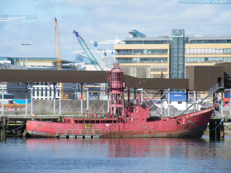
The Dublin 'docklands' developer, Harry Crosbie is launching a campaign for the return of the 134ft (floating) landmark, Kittiwake.

The former lightship which he (had berthed) alongside the Liffey and (opposite) of The Point Depot, now the O2, then one of his many docklands business ventures.

But the distinctive red ship, which was sold to him by its owners, the Commissioners of Irish Lights (CIL), for a reputed €60,000, is now in the possession of Dublin Port, which has docked it away from public view in Alexandra Basin within the port complex.

For more on this development of the former lightship, Independent.ie reports here.

As Afloat previously reported, it is almost a decade since Crosbie's plans to relocate the former lightship Kittiwake on the North Quay Wall, in front of the O2 Theatre, were refused permission.

The 1959 built lightship was converted in the 1980's by Irish Lights into an Automated Light-Float (ALF) and last served on station at South Rock off the Co. Down coast until 2005.

ALF Kittiwake was the second last lightship to operate in waters around Ireland.

Published in Historic Boats

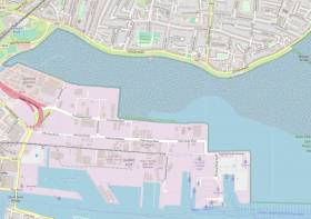
Clontarf residents will likely be wide-eyed at a recent “radical” proposal by Docklands developer Harry Crosbie to reclaim land from the sea off the North Dublin suburb.

According to The Irish Times, the property mogul suggests using Dutch engineering knowhow to reclaim some 250 acres between the existing Docklands and Clontarf Road, which currently lie within the River Tokla Estuary Special Protection Area, that could be repurposed for homes for 65,000 people and help tackle the housing crisis.

Crosbie — whose former warehouse on Tolka Quay Road was recently licensed by the State for post-Brexit freight checks — admitted to Marian Finucane on RTÉ Radio 1 on Saturday (17 August) that his plan was “radical” but that the people of Clontarf would come to see it make the area “a nicer place to live in over a period of 10 years”.

He also shot down similar recent proposals by Royal Institute of the Architects of Ireland president David Browne to reclaim land off Sandymount Strand, on the opposite side of Dublin Bay, as “a bridge too far”.

The Irish Times has more on the story HERE.

Published in Dublin Bay

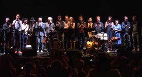
A new documentary 'Starboard Home' (on RTE One tonight at 10.15pm) which formed part of the 1916 Easter Rising centenary commemorations held in Dublin, involved musicians commissioned to produce works inspired by the capital, its port and the Liffey.

In a rare musicial opportunity, Dublin Port and the National Concert Hall invited Irish musicians to respond to the theme resulting to an acclaimed modern song cycle that rekindles the formative bond between the city and Dublin Bay through music, song and the spoken word.

Among musicians lined up for the unique commemorative event were James Vincent McMarrow and Gemma Hayes.

In conjunction with tonight's broadcast, Moira Sweeney’s film ‘Keepers of the Port’ will be airing on RTÉ’s Culture website.

So keep a look-out! for the Starboard Home documentary which is one not to be missed! 

Published in Maritime TV

#DublinPort - A plaque commemorating the first Irishman to die in the First World War has been unveiled in his home neighbourhood of Ringsend in Dublin's south Docklands, where many of his descendants still live.

As The Irish Times reports, Joseph Pierce Murphy died among 151 sailors who perished when the Royal Navy cruiser HMS Amphion was sunk by a mine in the North Sea on the morning of 6 August 1914.

Seven sailors from Cork were also killed that morning, and three of them were remembered at a Mass at the Naval Service base on Haulbowline in Cork Harbour last weekend.

The plaque unveiling on Wedneday 6 August behind St Patrick's Church on Thorncastle Street – just around the corner from Muphy's home at 2 Thorncastle Place – was presided over by Lord Mayor of Dublin Christy Burke and British Ambassador to Ireland Dominick Chilcott.

Also in attendance was Dublin Port Company chief Eamonn O’Reilly, who said: “It is appropriate and important that his family and the local community can pay tribute to the life of this young Navy sailor in his hometown of Ringsend, and I would encourage people to see the plaque in his honour.”

The Irish Times has much more on the story HERE.

Published in Dublin Port

#Docklands - Local business interests and marine authorities are mooting ambitious new plan to construct a dozen pontoons along the River Liffey in Dublin's Docklands in 2014.

The Sunday Times last weekend reported that the €4 million scheme, put forward by the Docklands Business Forum, has the backing of the Dublin Port Company and Waterways Ireland as well as Dublin City Council.

It forms part of the port's 30-year 'masterplan' and is intended to revive the Royal and Grand Canals that feed into the Liffey on the north and south sides respectively, and encourage visiting yachts to moor closer to the city centre.

"The Docklands has a huge resource for boats which we just need to improve," said the forum's chief executive Alan Robinson.

Among those suggested improvements is the refurbishing of Camden Lock on the Grand Canal Basin - but first in line are the pontoons, which were a temporary feature of the capital during last year's Tall Ships Festival.

The intention is to make these pontoons a permanent fixture between the East Link Bridge and the Samuel Beckett Bridge, to "generate a new type of activity in the city" in an area that recently hosted its first annual Riverfest, not to mention the once-in-a-lifetime FlightFest.

Published in Dublin Port
Tagged under

#MARINE NOTICE - The latest Marine Notice (No 61 of 2012) from the Department of Transport, Tourism and Sport (DTTAS) advises that J Murphy & Sons, on behalf of Dublin City Council, will construct a 600mm emergency overflow pipe from Spencer Dock Pump Station through the Liffey quay wall at North Wall Quay/New Wapping Street Junction, Dublin 1.

The work will commence on or around 23 November 2012 and will last approximately two weeks, weather permitting. The location of the works relating to maritime positions is:

Latitude 53° 20’ 49.431 N / Longitude 006° 14’ 08.171 W

The works area will be marked by red buoys. These buoys will be an appropriate distance from the works area and will clearly identify the scaffold when submerged due to high tide. The cantilever beams will project 1.5 metres out from the quay wall.

The only vessel used during the works will be a rescue boat which will be moored at the works location for its duration.

Published in Marine Warning

#POWER FROM THE SEA - The fourth International Conference on Ocean Energy (ICOE) begins tomorrow Wednesday 17 October at the Convention Centre in Dublin's Docklands.

Over 750 international experts and world-leading companies in ocean energy will gather in Ireland’s capital city for the three-day conference, hosted by the Sustainable Energy Authority of Ireland (SEAI) in association with the European Ocean Energy Association.

Global industry and academic experts in marine renewable energy will present over a hundred papers on themes important to growing this new marine sector.

The conference also provides an opportunity for a trade exhibition where many of the top industrial players will demonstrate the latest technologies in harnessing renewable energy from the sea.

The International Conference on Ocean Energy is the global marine energy event focused on the industrial development of renewable marine energy. Held every two years, the goal of the conference and exhibition is to share recent experiences from research and demonstration efforts.

It aims to accelerate development by stimulating collaboration networks between companies and research and development centres. It also specifically targets engagement of the experience of operators in related marine and power industry sectors.

For more details see the information flyer available to read or download HERE.

Published in Power From the Sea

#TALL SHIPS - Organisers of the Tall Ships Races Festival - which kicks off today in Dublin's Docklands - have announced visiting hours for members of the public to step on board some of the 43 vessels docked on the city's quays between now and Sunday.

A total of nine tall ships will have free access to the public at different times over the weekend, available on a first come first served basis.

On the south quays, the Amerigo Vespucci will be open today from 3pm to 7pm, tomorrow from 10.30am to 1pm and 3pm to 6pm, and Saturday from 10.30am to 1pm and 3pm to 7pm.

The Mexican tall ship Cuauhtemoc - the last of the fleet to arrive this morning - will be open till 7pm today, and from 10am till 11pm tomorrow and Saturday.

The Danmark has open hours today from 3.30pm to 5pm, from 1.30pm to 5pm tomorrow and on Saturday from 1pm to 4pm.

The Guayus stays open to the public today till 9pm this evening, and will be open again tomorrow and Saturday from 10am till 9pm, and on Sunday before the Parade of Sail from 10.30am to 1pm.

The Lord Nelson will be open on Saturday from 10am to 1pm and 2pm to 5pm, while the Pelican of London is open tomorrow and Saturday from 10am to 1pm and 3pm to 6pm, and on Sunday morning from 10.30am till 1pm.

Completing the south quays moorings, the Stavros S Niarchos will be open tomorrow from noon till 5pm and on Saturday from noon till 6pm.

On the north quays, the Fryderyk Chopin is open till 1pm today and again from 3pm to 6pm. It reopens tomorrow and Saturday from 10am till 1pm, and on Sunday from 10.30am to 1pm.

And the STS flagship Pogoria will welcome the public tomorrow from 10am to 6pm and again on Saturday from 10am till 2pm.

Meanwhile, don't forget that another great way to see the tall ships at their moorings is from the water on board the Allianz All-Aboard Liffey Cruise, with seats available from just €1!

Published in Tall Ships

#TALL SHIPS - A 15-year-old boy was rescued from the water at Dublin's Grand Canal Dock yesterday after getting into difficulty while swimming.

According to RTÉ News, the teenager from Blanchardstown was swimming with a number of friends at Hanover Quay amid preparations for the Tall Ships Races Festival when he went missing around lunchtime yesterday.

Fire officers reportedly retrieved the boy from the water and gave him CPR on the quayside before he was transferred to St Vincent's Hospital in Merrion.

The Irish Times reports that the teen was in the area to volunteer with the Kings of Concrete urban sports display group as part of the Tall Ships Races events.

Organisers later confirmed that the boy was not preparing for his volunteer work at the time of the incident, which underlines the importance of water safety for all volunteers and visitors at the Docklands festival starting tomorrow.

Safety is also paramount aboard the tall ships fleet as they make their way to the capital, with damage inflicted on nearly all the more than 40 vessels in stormy conditions in the Bay of Biscay, according to the Irish Independent.

Ecuadorian naval ship the Guayas suffered eight ripped sails in the storm, but the worst damage was sustained by the Polish schooner Captain Borchardt, which arrived in Dublin with a broken mast.

However, master of the skip Janus Zbierajewski jokingly described the experience as "absolutely perfect weather".

The bad weather was enough to force at least once ship to abandon the final race leg, with Sail Training Association flagship STS Pogoria arriving in Dublin Port some days ahead of schedule.

Published in Tall Ships

Waterways Ireland wishes to advise masters and owners that as part of the Docklands Summer Festival, yacht racing will take place in the Grand Canal Basin from 09.00 hrs until 16.00hrs on Sun 26th June.

On Sat 25th, there will be a practice session from 13.00hrs until 19.00hrs.

In addition 'Come and Try It' activities including canoeing and paddle-boarding for novices will take place in the inner basin beside the Waterways Ireland Visitors Centre, from 10.00hrs until 18.00 on both days.

There will be restricted movement of vessels in the Grand Canal Basin during the events, lock operations will be suspended once the events have commenced.

Commercial operators in the Dock are requested to adhere to these restrictions and the planned routes and schedules for the duration of the event.

Boat owners presently in the Grand Canal Basin should comply with all reasonable instructions and guidance from event marshals.

Published in Inland Waterways
Page 1 of 2

General Information on using Waterways Ireland inland navigations

Safety on the Water

All users of the navigations are strongly recommended to make themselves aware of safety on the water for whatever activity they are involved in and to read the advice offered by the various governing bodies and by:

The Dept. of Transport, Ireland: www.gov.ie/transport and The Maritime and Coastguard Agency, UK, The RNLI – Water Safety Ireland for information in terms of drowning prevention and water safety.

Registration of Vessels

All vessels using the Shannon Navigation, which includes the Shannon-Erne Waterways and the Erne System must be registered with Waterways Ireland. Only open undecked boats with an engine of 15 horsepower or less on the Shannon Navigation, and vessels of 10 horsepower or less on the Erne System, are exempt. Registration is free of charge.

Craft registration should be completed online at: https://www.waterwaysireland.org/online-services/craft-registration

Permits for use of the Grand and Royal Canals and the Barrow Navigation

All vessels using the Grand and Royal Canals and the Barrow Navigation must display appropriate valid Permit(s) i.e A Combined Mooring and Passage Permit (€126) and if not intending to move every five days, an Extended Mooring Permit (€152).

Permit applications should be completed online at: https://www.waterwaysireland.org/online-services/canal-permits

Passage on the Royal and Grand Canals – Dublin Area

For boat passage through the locks east of Lock 12 into / out of Dublin on either the Royal or Grand Canals, Masters are requested to contact the Waterways Ireland Eastern Regional Office (M-F 9.30am-4.30pm) on tel: +353(0)1 868 0148 or email [email protected] prior to making passage in order to plan the necessary lock-keeping assistance arrangements.

On the Grand Canal a minimum of two days notice prior to the planned passage should be given, masters should note that with the exception of pre-arranged events, a maximum of 2 boats per day will be taken through the locks, travelling either east or west.

Movements in or out of the city will be organised by prior arrangement to take place as a single movement in one day. Boaters will be facilitated to travel the system if their passage is considered to be safe by Waterways Ireland and they have the valid permit(s) for mooring and passage.

Newcomen Lifting Bridge

On the Royal Canal two weeks’ notice of bridge passage (Newcomen Lifting Bridge) is required for the pre-set lift date, and lock assistance will then also be arranged. A minimum of 2 boats is required for a bridge lift to go ahead.

Waterways Ireland Eastern Regional Office (Tel: +353(0)1 868 0148 or [email protected] ) is the point of contact for the bridge lift.

A maximum number of boats passing will be implemented to keep to the times given above for the planned lifts (16 for the Sat / Sun lifts & 8 for the weekday lifts). Priority will be given on a first come first served basis.

On day of lift, boaters and passengers must follow guidance from Waterways Ireland staff about sequence of passage under bridge & through Lock 1, and must remain within signed and designated areas.

Events Held on the Waterways

All organised events taking place on the waterways must have the prior approval of Waterways Ireland. This is a twelve week process and application forms must be accompanied with the appropriate insurance, signed indemnity and risk assessment. The application should be completed on the Waterways Ireland events page at :

https://www.waterwaysireland.org/online-services/event-approval

Time Limits on Mooring in Public Harbours

On the Shannon Navigation and the Shannon-Erne Waterway craft may berth in public harbours for five consecutive days or a total of seven days in any one month.

On the Erne System, revised Bye Laws state that: No master or owner shall permit a vessel, boat or any floating or sunken object to remain moored at or in the vicinity of any public mooring, including mooring at any other public mooring within 3 kilometres of that location, for more than 3 consecutive days and shall not moor at that same mooring or any other public mooring within 3 kilometres of that location within the following 3 consecutive days without prior permission by an authorised official.

Winter Mooring on the Shannon Navigation and Shannon Erne Waterway

Winter mooring may be availed of by owners during the period 1 Nov to 31 Mar by prior arrangement and payment of a charge of €63.50 per craft. Craft not availing of Winter Mooring must continue to comply with the “5 Day Rule”. Winter Mooring applications should be completed online at : https://www.waterwaysireland.org/online-services/winter-moorings-booking

Owners should be aware that electricity supply and water supply to public moorings is disconnected for the winter months. This is to protect against frost damage, to reduce running costs and to minimise maintenance requirements during the winter months.

Vessel owners are advised that advance purchasing of electricity on the power bollards leading up to the disconnection date should be minimal. Electricity credit existing on the bollards will not be recoverable after the winter decommissioning date. Both services will be reinstated prior to the commencement of the next boating season.

Smart Cards

Waterways Ireland smart cards are used to operate locks on the Shannon Erne Waterway, to access the service blocks, to use the pump-outs along the navigations, to avail of electrical power at Waterways Ireland jetties.

Berthing in Public Harbours

Masters are reminded of the following:

  • Equip their vessel with mooring lines of appropriate length and strength and only secure their craft to mooring bollards and cleats provided for this purpose.
  • Ensure the available berth is suitable to the length of your vessel, do not overhang the mooring especially on finger moorings on floating pontoon moorings.
  • Ensure mooring lines, electric cables and fresh water hoses do not create a trip hazard on public jetties for others users.
  • Carry sufficient fenders to prevent damage to your own vessel, other vessels and WI property.
  • Allow sufficient space between your vessel and the vessel ahead /astern (c.1m) for fire safety purposes and /or to recover somebody from the water.
  • Do not berth more than two vessels side by side and ensure there is safe access/egress at all times between vessels and onto the harbour itself.
  • Do not berth in such a way to prevent use of harbour safety ladders, slipways or pump-outs.
  • Do not allow the bow of your vessel to overhang the walkway of a floating mooring thus creating a hazard for others with an overhanging anchor or bow fendering.
  • Animals are not allowed to be loose or stray at any time.
  • Harbour and jetty infrastructure such as railings, power pedestals, fresh water taps, electric light poles, safety bollards, ladders etc are not designed for the purpose of mooring craft , they will not bear the strain of a vessel and will be damaged.
  • At Carrybridge on the Erne System, Masters of vessels are not permitted to use stern on mooring. Masters of vessels must use the mooring fingers for mooring of vessels and for embarkation / disembarkation from vessels.

Passenger Vessel Berths

Masters of vessels should not berth on passenger vessel berths where it is indicated that an arrival is imminent. Passenger vessels plying the navigations generally only occupy the berths to embark and disembark passengers and rarely remain on the berths for extended periods or overnight.

Lock Lead-in Jetties

Lead-in jetties adjacent to the upstream and downstream gates at lock chambers are solely for the purpose of craft waiting to use the lock and should not be used for long term berthing.

Vessel Wake

Vessel wake, that is, the wave generated by the passage of the boat through the water, can sometimes be large, powerful and destructive depending on the hull shape and engine power of the vessel. This wake can be detrimental to other users of the navigation when it strikes their craft or inundates the shoreline or riverbank. Masters are requested to frequently look behind and check the effect of their wake / wash particularly when passing moored vessels, on entering harbours and approaching jetties and to be aware of people pursuing other activities such as fishing on the riverbank.

Speed Restriction

A vessel or boat shall not be navigated on the Shannon Navigation at a speed in excess of 5 kph when within 200 metres of a bridge, quay, jetty or wharf, when in a harbour or canal or when passing within 100 metres of a moored vessel or boat.

Vessels navigating the Shannon-Erne Waterway should observe the general 5 kph speed limit which applies along the waterway. This is necessary in order to prevent damage to the banks caused by excessive wash from vessels.

Vessels navigating the Erne System should observe the statutory 5kt / 6mph / 10kph speed limit areas.

A craft on the Royal and Grand canals shall not be navigated at a speed in excess of 6km per hour.

A craft on the Barrow Navigation shall not be navigated at a speed in excess of 11km per hour except as necessary for safe navigation in conditions of fast flow.

Bank Erosion

Narrow sections of all the navigations are particularly prone to bank erosion due to the large wash generated by some craft. Masters are requested to be vigilant and to slow down to a speed sufficient to maintain steerage when they observe the wash of their craft inundating the river banks.

Unusual Waterborne Activity

Unusual waterborne vessels may be encountered from time to time, such as, hovercraft or amphibious aircraft / seaplanes. Masters of such craft are reminded to apply the normal “Rule of the Road” when they meet conventional craft on the water and to allow extra room to manoeuvre in the interest of safety.

Sailing Activity

Mariners will encounter large numbers of sailing dinghies from late June to August in the vicinity of Lough Derg, Lough Ree and Lower Lough Erne. Sailing courses are marked by yellow buoys to suit weather conditions on the day. Vessels should proceed at slow speed and with due caution and observe the rules of navigation when passing these fleets, as many of the participants are junior sailors under training.

Rowing

Mariners should expect to meet canoes and vessels under oars on any part of the navigations, but more so in the vicinity of Athlone, Carrick-on-Shannon, Coleraine, Enniskillen and Limerick. Masters are reminded to proceed at slow speed and especially to reduce their wash to a minimum when passing these craft as they can be easily upset and swamped due to their very low freeboard and always be prepared to give way in any given traffic situation.

Canoeing

Canoeing is an adventure sport and participants are strongly recommended to seek the advice of the sport’s governing bodies i.e Canoeing Ireland and the Canoe Association of Northern Ireland, before venturing onto the navigations.

Persons in charge of canoes are reminded of the inherent danger to these craft associated with operating close to weirs, sluice gates, locks and other infrastructure particularly when rivers are in flood and large volumes of water are moving through the navigations due to general flood conditions or very heavy localised precipitation e.g. turbulent and broken water, stopper waves. Shooting weirs is prohibited without prior permission of Waterways Ireland.

Canoeists should check with lockkeepers prior entering a lock to ensure passage is done in a safe manner. Portage is required at all unmanned locks.

Canoe Trail Network – "Blueways"

Masters of powered craft are reminded that a canoe trail network is being developed across all navigations and to expect more organised canoeing along these trails necessitating slow speed and minimum wash when encountering canoeists, rowing boats etc

Rockingham and Drummans Island Canals – Lough Key

It is expected that work on Rockingham and Drummans Island Canals on Lough Key will be completed in 2021. Access to these canals will be for non-powered craft only, eg canoes, kayaks, rowing boats.

Fast Powerboats and Personal Watercraft (Jet Skis)

Masters of Fast Powerboats (speed greater than 17kts) and Personal Watercraft (i.e.Jet Skis) are reminded of the inherent dangers associated with high speed on the water and especially in the confines of small bays and narrow sections of the navigations. Keeping a proper look-out, making early alterations to course and /or reducing speed will avoid conflict with slower vessels using the navigation. Personal Watercraft are not permitted to be used on the canals.

Towing Waterskiers, Wakeboarders, Doughnuts etc

Masters of vessels engaged in any of these activities are reminded of the manoeuvring constraints imposed upon their vessel by the tow and of the added responsibilities that they have to the person(s) being towed. These activities should be conducted in areas which are clear of conflicting traffic. It is highly recommended that a person additional to the master be carried to act as a “look-out” to keep the tow under observation at all times.

Prohibition on Swimming

Swimming in the navigable channel, particularly at bridges, is dangerous and is prohibited due to the risk of being run over by a vessel underway in the navigation.

Age Restrictions on operating of powered craft

In the Republic of Ireland, Statutory Instrument 921 of 2005 provides the legal requirements regarding the minimum age for operating of powered craft. The Statutory Instrument contains the following requirements:

- The master or owner of a personal watercraft or a fast power craft shall take all reasonable steps to ensure that a person who has not attained the age of 16 years does not operate or control the craft

- The master or owner of a pleasure craft powered by an engine with a rating of more than 5 horse power or 3.7 kilowatts shall take all reasonable steps to ensure that a person who has not attained the age of 12 years does not operate or control the craft.

Lifejackets and Personal Flotation Devices (PFDs)

Lifejackets and PFD’s are the single most important items of personal protective equipment to be used on a vessel and should be worn especially when the vessel is being manoeuvred such as entering / departing a lock, anchoring, coming alongside or departing a jetty or quayside.

In the Republic of Ireland, Statutory Instrument 921 of 2005 provides the legal requirements regarding the wearing of Personal Flotation Devices. The Statutory Instrument contains the following requirements:

- The master or owner of a pleasure craft (other than a personal watercraft) shall ensure, that there are, at all times on board the craft, sufficient suitable personal flotation devices for each person on board.

- A person on a pleasure craft (other than a personal watercraft) of less than 7 metres length overall shall wear a suitable personal flotation device while on board an open craft or while on the deck of decked craft, other than when the craft is made fast to the shore or at anchor.

- The master or owner of a pleasure craft (other than a personal watercraft) shall take all reasonable steps to ensure that a person who has not attained the age of 16 years complies with paragraph above.

- The master or owner of a pleasure craft (other than a personal watercraft), shall take all reasonable steps to ensure that a person who has not attained the age of 16 years wears a suitable personal flotation device while on board an open craft or while on the deck of a decked craft other than when it is made fast to the shore or at anchor.

- The master or owner of a pleasure craft (other than a personal watercraft) shall take all reasonable steps to ensure that a person wears a suitable personal flotation device, at all times while – (a) being towed by the craft, (b) on board a vessel or object of any kind which is being towed by the craft.

Further information is available at: http://www.irishstatutebook.ie/eli/2005/si/921/made/en/print

Firing Range Danger Area – Lough Ree

The attention of mariners is drawn to the Irish Defence Forces Firing Range situated in the vicinity of buoys No’s 2 and 3, on Lough Ree on the Shannon Navigation. This range is used regularly for live firing exercises, throughout the year, all boats and vessels should stay clear of the area marked with yellow buoys showing a yellow "X" topmark and displaying the word "Danger".

Shannon Navigation, Portumna Swing Bridge Tolls

No attempt should be made by Masters’ of vessels to pay the bridge toll while making way through the bridge opening. Payment will only be taken by the Collector from Masters when they are secured alongside the jetties north and south of the bridge.

Navigating from Killaloe to Limerick on the Shannon Navigation

The navigation from Killaloe to Limerick involves passage through Ardnacrusha locks, the associated headrace and tailrace and the Abbey River into Limerick City. Careful passage planning is required to undertake this voyage. Considerations include: lock passage at Ardnacrusha, water flow in the navigation, airdraft under bridges on Abbey River in Limerick, state of tide in Limerick

Users are advised to contact the ESB Ardnacrusha hydroelectric power station (00353 (0)87 9970131) 48 hours in advance of commencing their journey to book passage through the locks at Ardnacrusha. It is NOT advised to undertake a voyage if more than one turbine is operating (20MW), due to the increased velocity of flow in the navigation channel, which can be dangerous. To ascertain automatically in real time how many turbines are running, users can phone +353 (0)87 6477229.

For safety reasons the ESB has advised that only powered craft with a capacity in excess of 5 knots are allowed to enter Ardnacrusha Headrace and Tailrace Canals.

Passage through Sarsfield Lock should be booked on +353-87-7972998, on the day prior to travel and it should be noted also that transit is not possible two hours either side of low water.

A Hydrographic survey in 2020 of the navigation channel revealed that the approach from Shannon Bridge to Sarsfield Lock and the Dock area has silted up. Masters of vessels and water users are advised to navigate to the Lock from Shannon bridge on a rising tide one or two hours before High Tide.

Lower Bann Navigation

The attention of all users is drawn to the “Users Code for the Lower Bann”, in particular to that section covering “Flow in the River” outlining the dangers for users both on the banks and in the navigation, associated with high flow rates when the river is in spate. Canoeists should consult and carry a copy of the “Lower Bann Canoe Trail” guide issued by the Canoe Association of Northern Ireland. Users should also contact the DfI Rivers Coleraine, who is responsible for regulating the flow rates on the river, for advisory information on the flow rates to be expected on any given day.

DfI Rivers Coleraine. Tel: 0044 28 7034 2357 Email: [email protected]

Lower Bann Navigation – Newferry – No wake zone

A No Wake Zone exists on the Lower Bann Navigation at Newferry. Masters of vessels are requested to proceed at a slow speed and create no wake while passing the jetties and slipways at Newferry.

Overhead Power Lines (OHPL) and Air draft

All Masters must be aware of the dangers associated with overhead power lines, in particular sailing vessels and workboats with cranes or large air drafts. Voyage planning is a necessity in order to identify the location of overhead lines crossing the navigation.

Overhead power line heights on the River Shannon are maintained at 12.6metres (40 feet) from Normal Summer level for that section of navigation, masters of vessels with a large air draft should proceed with caution and make additional allowances when water levels are high.

If a vessel or its equipment comes into contact with an OHPL the operator should NOT attempt to move the vessel or equipment. The conductor may still be alive or re-energise automatically. Maintain a safe distance and prevent third parties from approaching due to risk of arcing. Contact the emergency services for assistance.

Anglers are also reminded that a minimum ground distance of 30 metres should be maintained from overhead power lines when using a rod and line.

Submarine Cables and Pipes

Masters of vessels are reminded not to anchor their vessels in the vicinity of submarine cables or pipes in case they foul their anchor or damage the cables or pipes. Look to the river banks for signage indicating their presence.

Water Levels - Precautions

Low Water Levels:

When water levels fall below normal summer levels masters should be aware of:

Navigation

To reduce the risk of grounding masters should navigate on or near the centreline of the channel, avoid short cutting in dog-legged channels and navigating too close to navigation markers.

Proceeding at a slow speed will also reduce “squat” effect i.e. where the vessel tends to sit lower in the water as a consequence of higher speed.

Slipways

Reduced slipway length available under the water surface and the possibility of launching trailers dropping off the end of the concrete apron.

More slipway surface susceptible to weed growth requiring care while engaged in launching boats, from slipping and sliding on the slope. Note also that launching vehicles may not be able to get sufficient traction on the slipway once the craft is launched to get up the incline.

Bank Erosion

Very dry riverbanks are more susceptible to erosion from vessel wash.

Lock Share

Maximising on the number of vessels in a lock will ensure that the total volume of water moving downstream is decreased. Lock cycles should be used for vessels travelling each way.

High Water Levels:

When water levels rise above normal summer level masters should be aware of:

Navigation

Navigation marks will have reduced height above the water level or may disappear underwater altogether making the navigable channel difficult to discern.

In narrow sections of the navigations water levels will tend to rise more quickly than in main streams and air draft at bridges will likewise be reduced.

There will also be increased flow rates particularly in the vicinity of navigation infrastructure such as bridges, weirs, locks etc where extra care in manoeuvring vessels will be required.

Harbours and Jetties

Due care is required in harbours and at slipways when levels are at or near the same level as the harbour walkways' as the edge will be difficult to discern especially in reduced light conditions. It is advised that Personal Flotation Devices be worn if tending to craft in a harbour in these conditions.

Slipways

Slipways should only be used for the purpose of launching and recovering of water craft or other objects from the water. Before using a slipway it should be examined to ensure that the surface has sufficient traction/grip for the intended purpose such as launching a craft from a trailer using a vehicle, that there is sufficient depth of water on the slipway to float the craft off the trailer before the concrete apron ends and that the wheels of the trailer do not drop off the edge of the slipway. That life-saving appliances are available in the vicinity, that the vehicle is roadworthy and capable of coping with the weight of the trailer and boat on the incline. It is recommended that slipway operations are conducted by two persons.

Caution to be Used in Reliance upon Aids to Navigation

The aids to navigation depicted on the navigation guides comprise a system of fixed and floating aids to navigation. Prudent mariners will not rely solely on any single aid to navigation, particularly a floating aid to navigation. With respect to buoys, the buoy symbol is used to indicate the approximate position of the buoy body and the ground tackle which secures it to the lake or river bed. The approximate position is used because of the practical limitations in positioning and maintaining buoys in precise geographical locations. These limitations include, but are not limited to, prevailing atmospheric and lake/river conditions, the slope of and the material making up the lake/river bed, the fact that the buoys are moored to varying lengths of chain, and the fact that the buoy body and/or ground tackle positions are not under continuous surveillance. Due to the forces of nature, the position of the buoy body can be expected to shift inside and outside the charted symbol.

Buoys and perches are also moved out of position or pulled over by those mariners who use them to moor up to instead of anchoring. To this end, mariners should always monitor their passage by relating buoy/perch positions with the published navigation guide. Furthermore, a vessel attempting to pass close by always risks collision with a yawing buoy or with the obstruction that the buoy or beacon/perch marks.

Masters of Vessels are requested to use the most up to date Navigation guides when navigating on the Inland Waterways.

Information taken from Special Marine Notice No 1 of 2023