Menu

Ireland's sailing, boating & maritime magazine

Inland afloat headers


Displaying items by tag: Bluefin Tuna

Twenty-two charter angling vessels have been granted authorisation to participate in a bluefin tuna data collection programme after a successful pilot last year.

The Tuna CHART (CatcH And Release Tagging) programme will see skippers catch, tag, measure and release Atlantic bluefin tuna for data collection purposes off the Irish coast.

The authorised vessels, which are located in Cork, Clare, Galway, Sligo and Donegal, will support an international scientific programme to increase knowledge of the behaviour and abundance of bluefin tuna in Irish waters and across its distribution generally.

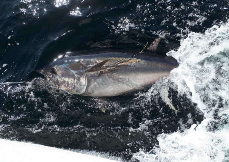
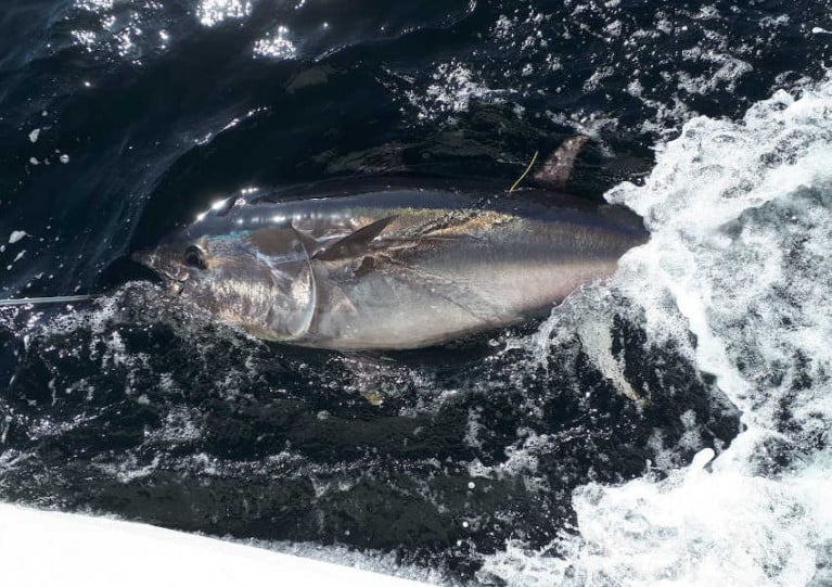
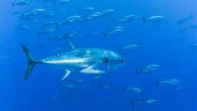
Atlantic bluefin tuna, the largest tuna in the world, frequent Irish coastal waters to feed during the species’ annual migration through North Atlantic waters.

The bluefin tuna is prized by sea anglers for its power and fighting ability and is a very valuable commercial species, though there is currently no sport or commercial fishery for bluefin tuna in Ireland.

The new programme, which has been developed by Inland Fisheries Ireland and the Marine Institute in partnership with the Sea Fisheries Protection Authority and the former Departments of Agriculture, Food and the Marine, and Communications, Climate Action and Environment, will operate again in 2020 having commenced on a pilot basis in 2019.

Eamon Ryan TD, minister with responsibility for inland fisheries, said: “The 22 angling vessels authorised by my department, increased from 15 last year, will contribute substantially to essential bluefin tuna data collection as they migrate along the Irish coastline.

“The recreational fisheries sector is crucial in the delivery of this research programme and we look forward to continue working with all the State agencies involved.

“I want to acknowledge the key role of the authorised charter skippers and their crews who are bringing their unique expertise to bear on providing valuable data for scientific purposes, and the ‘citizen scientist’ anglers who will catch the fish. The fact that 209 fish were tagged last year with no mortalities is a great achievement by the skippers.”

The Sea Fisheries Protection Authority and Inland Fisheries Ireland will undertake inspections and patrols around the coast to ensure this remains a strictly controlled programme.

A full list of authorised skippers can be found at www.fisheriesireland.ie/bluefin

Published in Angling

Building on the success of last year’s Tuna CHART (CatcH And Release Tagging) pilot programme, a bluefin tuna research catch-and-release fishery for Ireland will operate in 2020.

A maximum of 25 authorisations may be granted to qualifying angling charter vessel skippers around the Irish coast for this fishery which will open on Wednesday 1 July and close on Thursday 12 November, without exception.

And depending on the successful operation and review of this year’s fishery, it is intended that a scientific catch and release fishery may also operate in 2021 and 2022.

Atlantic bluefin tuna, the largest tuna in the world, frequent Irish coastal waters to feed during its annual migration through North Atlantic waters. The bluefin tuna is prized by sea anglers for its power and fighting ability and is a very valuable commercial species.

The Tuna CHART programme is a collaborative scientific programme between Inland Fisheries Ireland (IFI) and the Marine Institute in partnership with the Sea Fisheries Protection Authority, the Department of Agriculture, Food and the Marine (DAFM) and the Department of Communications, Climate Action and Environment (DCCAE).

In 2019, the Tuna CHART pilot programme authorised 15 charter skippers to operate a scientific fishery, in which anglers participated fully, to catch, tag and release bluefin tuna.

These professional skippers were trained to tag, measure and record bluefin data and over the course of the 2019 three month season, 219 bluefin tuna were caught, tagged and released. As many as eight bluefin were tagged on one fishing trip.

All tuna were carefully handled subject to strict guidelines set by the Tuna CHART programme and all were released alive. Data from the tagging programme are being collated by the partnership for reporting to the International Commission for the Conservation of Atlantic Tuna (ICCAT).

As with the pilot programme, this year’s authorised skippers will be required to have high specification rods, reels and line in advance of the open season in order to bring the fish alongside in a timely manner. Skippers will be required to collect data on every bluefin trip undertaken and each bluefin tuna they catch, tag and release.

A call for applications for the 2020 fishing season will be announced next Tuesday 18 February and the last date for the receipt of a completed application will be 1pm on Friday 6 March.

Published in Angling

While there is no sport or commercial fishery for Bluefin tuna in Ireland, a pilot Bluefin Tuna Data Collection Programme has been developed by Inland Fisheries Ireland (IFI) and the Marine Institute (MI) in partnership with the Sea Fisheries Protection Authority (SFPA) the Department of Agriculture, Food and the Marine (DAFM) and the Department for Communications, Climate Action and Environment (DCCAE) . This programme, comprising 15 authorised charter angling skippers, commenced on the 15th of August in order to catch, tag and release Atlantic bluefin tuna for data collection purposes off the Irish coast and is part of the International Convention on the Conservation of Atlantic Tuna (ICCAT) research programme which is supported by the EU Commission.

These authorised skippers with vessels operating out of ports located in Cork, Clare, Galway, Sligo and Donegal are supporting scientific work to increase knowledge of the behaviour and abundance of Bluefin tuna in Irish waters. All authorised skippers have participated in training with guidance provided around fish handling, welfare, tagging and data recording. Participants in the programme catch, tag and release Bluefin tuna while adhering to strict fish safety and handling procedures at all times.

Authorisations were originally granted to the 15 charter skippers from mid-August until mid-October. This pilot project has been very successful with 201 fish tagged and released to date with utmost consideration to their welfare. Due to the migratory patterns of Bluefin tuna, there has been little activity in the South and South West. As a result, the fishing season will now be extended for a further four weeks until the 12th of November to seek data which will help improve our knowledge of the population structure and distribution of Bluefin tuna in these regions. There will be no further extensions as lower water temperatures could hinder post-release survival of these fish after mid-November. 

Minister Creed said today: “I am delighted by the excellent cooperation shown between my Department, DCCAE, SFPA, MI and the IFI in the development and management of this pilot project. The extension of the programme will provide an opportunity to gather further data and improve our understanding of the migratory patterns of Bluefin Tuna around our coasts.”

Minister Canney said: “I fully support the continued involvement of my Department and Inland Fisheries Ireland in the collaborative pilot project to collect valuable data on Bluefin tuna in Irish coastal waters. The partnership approach has led to a very successful round of data gathering with some 200 fish tagged and recorded since the pilot programme opened.

“The extension of the programme for a further four weeks will provide an excellent opportunity to encourage the collaborative effort and most importantly provide a research dividend by increasing the data collected. I have approved the issuing of renewed authorisations by my Department for the sea angling vessels participating in the initiative to continue until the 12th of November” he added.

The Sea Fisheries Protection Authority and Inland Fisheries Ireland will undertake inspections and patrols around the coast to ensure this remains a strictly controlled fishery. Anglers wishing to engage in this fishery must only do so on a sea angling vessel specifically authorised to participate in the pilot programme. Any person engaging in this fishery on any vessel which is not appropriately authorised will be in breach of the Sea-Fisheries and Maritime Jurisdiction (Bluefin Tuna) Regulations 2019 (S.I. No. 265 of 2019).

A full list of authorised skippers can be found here

Published in Angling
Tagged under

Fifteen angling vessels will soon be granted authorisation to participate in Tuna CHART (Catch and Release Tagging), a pilot Bluefin Tuna Data Collection Programme.

As previously reported for Afloat.ie by Lorna Siggins, the programme will see the 15 authorised vessels catch, tag and release Atlantic bluefin tuna for data collection purposes off the Irish coast.

These vessels, which are located in Cork, Clare, Galway, Sligo and Donegal, will support scientific work to increase knowledge of the behaviour and abundance of bluefin tuna in Irish waters — which currently do not host a sport or commercial fishery for the species.

The new programme, which has been developed by Inland Fisheries Ireland (IFI) and the Marine Institute in partnership with the Sea Fisheries Protection Authority (SFPA), the Department of Agriculture, Food and the Marine and the Department for Communications, Climate Action and Environment (DCCAE), will operate on a pilot basis this year.

Authorisations will be granted from mid-August until mid-October, and all skippers and trained crew have participated in training with guidance provided around fish handling, welfare, tagging and data recording.

Participants in the programme will catch, tag and release bluefin tuna while adhering to strict fish safety and handling procedures at all times.

Marine Minister Michael Creed has welcomed the initiative. “My department has been working on this project for two years at both EU and domestic levels and I am happy to announce the commencement of the project this month,” he said.

“This initiative will allow the Marine Institute and Inland Fisheries Ireland to collect valuable data on the migratory patterns of bluefin tuna in Irish waters in a tightly controlled environment.

“This project has been a wonderful example of co-operation between my department, DCCAE, SFPA, IFI and the Marine Institute and I am looking forward to the continued development of this relationship.”

Sean Canney, Minister with responsibility for inland fisheries, added: “The angling vessels which will be receiving authorisation from my department will contribute in a very tangible way to important data collection around Bluefin tuna as they migrate past the Irish coastline.

“The recreational fisheries sector is crucial in the delivery of this pilot programme and we look forward to working with all the State agencies involved and critically with the skippers and their crews who have received authorisations in providing valuable data for scientific purposes.”

The SFPA and IFI will undertake inspections and patrols around the coast to ensure this remains a strictly controlled fishery.

Anglers wishing to engage in this fishery must only do so on a sea angling vessel specifically authorised to participate in the pilot programme. Any person engaging in this fishery on any vessel which is not appropriately authorised will be in breach of the Sea-Fisheries and Maritime Jurisdiction (Bluefin Tuna) Regulations 2019 (SI No 265 of 2019).

Published in Angling

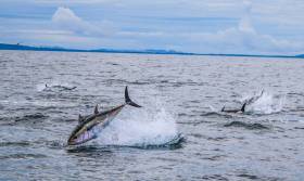
The rapid swimming migratory Atlantic bluefin tuna may be targeted by a limited number of Irish recreational craft under a pilot scientific research programme run by several State agencies writes Lorna Siggins.

Inland Fisheries Ireland (IFI) and the Marine Institute are seeking expressions of interest from up to 15 sea angling vessels, which would be authorised to run a catch, tag and release programme to collect data on the movements of the fish for the first time.

Atlantic bluefin tuna is the largest tuna and takes in the Irish coastline on its migratory track between the Mediterranean and the central Atlantic. It can reach a weight of over 600 kg, and over three metres in length, and can live for over 30 years.

Under International Commission for the Conservation of Atlantic Tunas (ICCAT) rules, Ireland could not allow targeted angling of bluefin tuna for data collection.

Last year, a European Commission audit had criticised the State for a “complete lack of control” over the illegal capture of bluefin tuna by sea anglers off the west coast.

It cited IFI evidence that a “targeted” recreational fishery for bluefin tuna had developed along the west coast of Ireland, with “numerous chartering companies advertising trips for tourists over the internet”.

The audit said there was evidence that some catch was being kept, landed and offered for sale in breach of regulations, given that Ireland had no quota.

However, IFI says that changes secured by Ireland at an ICCAT annual meeting last year will allow limited targeting of the species by recreational anglers, but for scientific purposes only.

The new pilot programme is being developed in partnership with the Sea Fisheries Protection Authority (SFPA), the Department of Agriculture, Food and Marine and Department of Communications, Climate Action and Environment.

Minister for Marine Michael Creed said he warmly welcomed the new pilot programme which would “build on and complement the extensive scientific work undertaken in recent years by the Marine Institute” and “increase our knowledge of the behaviour and abundance of bluefin tuna in the waters off the Irish coast”.

Applicants for the new data collection pilot programme will be assessed on the basis of previous experience in undertaking “collaborative research and scientific work”, and must have a minimum of five years’ experience of sea angling in Irish waters.

Applicants must also have experience in targeting large pelagic fish, and be equipped for same, and be willing to operate under specific authorisation controls, IFI says.

Authorisations will be valid from mid-August until mid-October of this year, IFI says, and strict fish safety and handling procedures will have to be followed at all times.

Training will be required in fish handling, welfare, tagging and data recording, and all vessels will be monitored by fisheries observers, IFI says.

Both IFI and the SFPA will “undertake inspections and patrols around the coast”, it says, and “any unauthorised skippers found targeting bluefin tuna will be prosecuted”.

It says anglers may participate in the fishery by booking places on an authorised vessel, and full details of the programme are on.

Published in Marine Science
Tagged under

Minister for Agriculture, Food and the Marine, Michael Creed T.D., today announced that he has secured approval at EU and international level for the introduction of a science-based catch, tag and release fishery for Bluefin tuna for Irish recreational anglers. This scheme will complement the work on satellite tagging of bluefin tuna that is being undertaken by the Marine Institute.

Minister Creed said that “As part of the negotiations on the new international management plan for bluefin tuna in the east Atlantic, Ireland was able to secure an agreement that will allow countries like Ireland, that do not have a commercial Bluefin tuna quota, to operate a catch-tag-release fishery for gathering scientific data.” This new management plan was adopted at the 2018 International Commission for the Conservation of Atlantic Tunas (ICCAT) Annual Meeting. 

Minister Creed continued “My Department is currently working with the Marine Institute and the Sea Fisheries Protection Authority on a pilot project that will allow up to 15 angling vessels with trained tagging operators to target bluefin tuna in 2019. This aim of the project is to build on work undertake to date and to increase our knowledge of the behaviour and abundance of BFT in the waters off the Irish coast. It will also provide an ancillary benefit in that it will support angling tourism in peripheral coastal communities, including in particular Donegal.”

Previously, under ICCAT rules, Ireland could not allow targeted angling for bluefin tuna as we do not have a bluefin tuna quota. The changes secured by Ireland will now allow targeting for tagging purposes only by recreational anglers. 

Minister Creed added “Our fishing industry has expressed concerns about the increasing numbers of Bluefin tuna in the Irish 200 miles zone and this programme will allow us to understand more about blue fin tuna - their habitat, migration patterns and concentration in waters around Ireland.”

The exact details of the pilot scheme will be developed over the coming period in consultation with the Department of Communications, Climate Action and Environment which is responsible for angling.

Published in Angling
Tagged under

#Bluefin- A Donegal TD's push for a bluefin tuna quota for local game anglers has prompted a meeting between Marine Minister Simon Coveney and the EU Fisheries Commissioner.

According to Donegal Now, Thomas Pringle TD has welcomed the move to request a three-tonne quota for bluefin "despite the fact that I’ve brought this proposal before the Dáil on a number of occasions over the past year".

As previously reported on Afloat.ie, Inland Fisheries Ireland said that any initiative to develop a catch-and-release fishery for bluefin in Irish waters would demand struct protocols and reporting to the International Commission for the Conservation of Atlantic Tunas (ICCAT).

But the independent Dáil deputy says recreational angling for bluefin tuna "could bring huge potential for Donegal in terms of job creation and boosting tourism in the region".

Donegal Now has more on the story HERE.

Published in Fishing

#bluefintuna – Sea anglers and charter boat skippers are reminded that the Bluefin Tuna recreational fishery remains closed in 2014. Inland Fisheries Ireland (IFI) and the Sea-Fisheries Protection Authority (SFPA) have released updated information in relation to the recreational catches of Bluefin tuna in Ireland. European fisheries regulations governing the catching, landing and sale of Bluefin tuna direct states that unless a Member State has specifically assigned a portion of their annual national quota to sports and recreational fisheries to target these fish no such fishing can take place.
Current Bluefin Tuna fisheries management regulations (EU Reg 302/2009 and International Commission for the Conservation of Atlantic Tunas( ICCAT) Recommendation 12-03) stipulate that recreational and sport fisheries may be facilitated by Member States by allocating a specific national Blue Fin Tuna quota to the sectors, but because Ireland does not have a quota the EU has advised that a specific recreational fishery cannot be operated.
Dr Ciaran Byrne, CEO of IFI said: "IFI is supportive of hard-pressed coastal communities and the marine sector in particular and are aware of the economic boost which recreational angling can bring to such peripheral communities. In this regard, IFI continues to actively investigate the possibility of operating a recreational bluefin tuna catch and release fishery."
Any initiative by IFI to develop a catch and release fishery for recreational fishers in Irish waters will demand strict catch-and release protocols with obligatory catch logging and reporting to the International Commission for the Conservation of Atlantic Tunas (ICCAT). Such a proposal from Ireland will need the input and support of Ireland's regulatory maritime agencies to prepare a submission for consideration by the Scientific Committee ICCAT and the European Commission.
In the meantime, any Bluefin Tuna mortalities arising from fish accidentally caught in the course of angling must be notified to SFPA who are charged with the enforcement of the above regulations. The fish will be confiscated and disposed of.
Susan Steele, Chair of the SFPA said: "Ireland does not have a direct fishery for Bluefin Tuna in Ireland. Ireland does have a 1% by catch of Bluefin Tuna as part of the Northern Albacore fishery. The vessels that partake in the Northern Albacore fishery must obtain a specific fishing authorisation from the Department of Agriculture, Food & Marine. For anyone engaged in sports or recreational sea angling this means that if a Bluefin Tuna is caught while sea angling it has to be immediately released as the fish cannot be targeted or landed by an Irish boat."

Published in Angling
Tagged under

#Angling - Inland Fisheries Ireland (IFI) has urged marine sport anglers to put conservation first when it comes to the endangered bluefin tuna - particularly those in the tuna hotspot of Donegal Bay.

In a statement, the national fisheries body said: "For a long time, Ireland has been recognised for its marine sport fishing. The vast variety and quality of our angling has given the country a reputation of which we are justly proud."

Bluefin tuna catches by the commercial fishing fleet targeting other species were first reported in the 1980s, and such reports became quite common on the west coast by the mid 1990s, though no fish fell to rod and line until 2000. 

The following year, a new Irish and European record was set by Adrian Mulloy, fishing with skipper Michael Callaghan. On the 5 October 2001 Adrian caught a fish of 968lbs near Rathlin O’Beirne Island.

In 2002 and 2003, more bluefin tuna were caught and one boat contributed to the 'Tag a Giant' programme run by Stanford University and supported in Ireland by Bord Iascaigh Mhara (BIM).

"While these were heady days for big game fishing in Ireland, it all happened against the backdrop of a global decline in a species that is now famously threatened by overfishing," said IFI.

In 2012, European regulations governing the harvesting of bluefin tuna were changed as the species became even more endangered. 

Ireland does not have a bluefin tuna quota, and for this reason "no allocation is available for sports or recreational fishing," said the IFI statement. "Furthermore, there is no facility in Irish fisheries regulations to permit angler-caught bluefin tuna to be landed into any Irish port, and there is no provision for the sale of these fish. 

"While IFI would love to see the development of a sustainable fishery for this wonderful species, given the continued significant decline of the species and the fragile nature of the stock, the key imperative has to be one of conservation."

Published in Angling
Tagged under

#FISHING - Dingle fishermen trawling for tuna off the south-west coast of Ireland found a big surprise in their nets this week in the form of an enormous 2-metre-long bluefin.

As The Irish Times reports, the Atlantic bluefin is considered one of the big game fish and is highly sought-after for top-quality sushi, a demand that has led to its adding to the endangered species list.

Strict quotas have been placed on bluefin for fishermen who normally trawl for albacore tuna - but the Dingle boats Fiona K and the Atlantic Venture were lucky that their unexpected catch was within the 1% they are allowed each year.

The 140kg tuna is set to end up in shops and restaurants in Dingle and throughout Kerry for much less than one would pay for such fish in Japan, where a bluefin double the size went for over €600,000 earlier this year.

Meanwhile, an even bigger bluefin was snappped up by eager fish lovers at Limerick's Milk Market last weekend.

The 250kg goliath was caught 600 miles off Castletownbere in Co Cork by local fisherman JD Sullivan, according to the Limerick Leader.

“The tuna migrate up the west coast of Ireland around this time of year, but very few of them are caught,” said Paul Cusack of Rene Cusack’s fish shop in the market.

It's leading some to question if there's something in the water, with news from Angling Times of a giant 189lb common skate recently caught off the coast of Northern Ireland.

Published in Fishing
Page 2 of 2

General Information on using Waterways Ireland inland navigations

Safety on the Water

All users of the navigations are strongly recommended to make themselves aware of safety on the water for whatever activity they are involved in and to read the advice offered by the various governing bodies and by:

The Dept. of Transport, Ireland: www.gov.ie/transport and The Maritime and Coastguard Agency, UK, The RNLI – Water Safety Ireland for information in terms of drowning prevention and water safety.

Registration of Vessels

All vessels using the Shannon Navigation, which includes the Shannon-Erne Waterways and the Erne System must be registered with Waterways Ireland. Only open undecked boats with an engine of 15 horsepower or less on the Shannon Navigation, and vessels of 10 horsepower or less on the Erne System, are exempt. Registration is free of charge.

Craft registration should be completed online at: https://www.waterwaysireland.org/online-services/craft-registration

Permits for use of the Grand and Royal Canals and the Barrow Navigation

All vessels using the Grand and Royal Canals and the Barrow Navigation must display appropriate valid Permit(s) i.e A Combined Mooring and Passage Permit (€126) and if not intending to move every five days, an Extended Mooring Permit (€152).

Permit applications should be completed online at: https://www.waterwaysireland.org/online-services/canal-permits

Passage on the Royal and Grand Canals – Dublin Area

For boat passage through the locks east of Lock 12 into / out of Dublin on either the Royal or Grand Canals, Masters are requested to contact the Waterways Ireland Eastern Regional Office (M-F 9.30am-4.30pm) on tel: +353(0)1 868 0148 or email [email protected] prior to making passage in order to plan the necessary lock-keeping assistance arrangements.

On the Grand Canal a minimum of two days notice prior to the planned passage should be given, masters should note that with the exception of pre-arranged events, a maximum of 2 boats per day will be taken through the locks, travelling either east or west.

Movements in or out of the city will be organised by prior arrangement to take place as a single movement in one day. Boaters will be facilitated to travel the system if their passage is considered to be safe by Waterways Ireland and they have the valid permit(s) for mooring and passage.

Newcomen Lifting Bridge

On the Royal Canal two weeks’ notice of bridge passage (Newcomen Lifting Bridge) is required for the pre-set lift date, and lock assistance will then also be arranged. A minimum of 2 boats is required for a bridge lift to go ahead.

Waterways Ireland Eastern Regional Office (Tel: +353(0)1 868 0148 or [email protected] ) is the point of contact for the bridge lift.

A maximum number of boats passing will be implemented to keep to the times given above for the planned lifts (16 for the Sat / Sun lifts & 8 for the weekday lifts). Priority will be given on a first come first served basis.

On day of lift, boaters and passengers must follow guidance from Waterways Ireland staff about sequence of passage under bridge & through Lock 1, and must remain within signed and designated areas.

Events Held on the Waterways

All organised events taking place on the waterways must have the prior approval of Waterways Ireland. This is a twelve week process and application forms must be accompanied with the appropriate insurance, signed indemnity and risk assessment. The application should be completed on the Waterways Ireland events page at :

https://www.waterwaysireland.org/online-services/event-approval

Time Limits on Mooring in Public Harbours

On the Shannon Navigation and the Shannon-Erne Waterway craft may berth in public harbours for five consecutive days or a total of seven days in any one month.

On the Erne System, revised Bye Laws state that: No master or owner shall permit a vessel, boat or any floating or sunken object to remain moored at or in the vicinity of any public mooring, including mooring at any other public mooring within 3 kilometres of that location, for more than 3 consecutive days and shall not moor at that same mooring or any other public mooring within 3 kilometres of that location within the following 3 consecutive days without prior permission by an authorised official.

Winter Mooring on the Shannon Navigation and Shannon Erne Waterway

Winter mooring may be availed of by owners during the period 1 Nov to 31 Mar by prior arrangement and payment of a charge of €63.50 per craft. Craft not availing of Winter Mooring must continue to comply with the “5 Day Rule”. Winter Mooring applications should be completed online at : https://www.waterwaysireland.org/online-services/winter-moorings-booking

Owners should be aware that electricity supply and water supply to public moorings is disconnected for the winter months. This is to protect against frost damage, to reduce running costs and to minimise maintenance requirements during the winter months.

Vessel owners are advised that advance purchasing of electricity on the power bollards leading up to the disconnection date should be minimal. Electricity credit existing on the bollards will not be recoverable after the winter decommissioning date. Both services will be reinstated prior to the commencement of the next boating season.

Smart Cards

Waterways Ireland smart cards are used to operate locks on the Shannon Erne Waterway, to access the service blocks, to use the pump-outs along the navigations, to avail of electrical power at Waterways Ireland jetties.

Berthing in Public Harbours

Masters are reminded of the following:

  • Equip their vessel with mooring lines of appropriate length and strength and only secure their craft to mooring bollards and cleats provided for this purpose.
  • Ensure the available berth is suitable to the length of your vessel, do not overhang the mooring especially on finger moorings on floating pontoon moorings.
  • Ensure mooring lines, electric cables and fresh water hoses do not create a trip hazard on public jetties for others users.
  • Carry sufficient fenders to prevent damage to your own vessel, other vessels and WI property.
  • Allow sufficient space between your vessel and the vessel ahead /astern (c.1m) for fire safety purposes and /or to recover somebody from the water.
  • Do not berth more than two vessels side by side and ensure there is safe access/egress at all times between vessels and onto the harbour itself.
  • Do not berth in such a way to prevent use of harbour safety ladders, slipways or pump-outs.
  • Do not allow the bow of your vessel to overhang the walkway of a floating mooring thus creating a hazard for others with an overhanging anchor or bow fendering.
  • Animals are not allowed to be loose or stray at any time.
  • Harbour and jetty infrastructure such as railings, power pedestals, fresh water taps, electric light poles, safety bollards, ladders etc are not designed for the purpose of mooring craft , they will not bear the strain of a vessel and will be damaged.
  • At Carrybridge on the Erne System, Masters of vessels are not permitted to use stern on mooring. Masters of vessels must use the mooring fingers for mooring of vessels and for embarkation / disembarkation from vessels.

Passenger Vessel Berths

Masters of vessels should not berth on passenger vessel berths where it is indicated that an arrival is imminent. Passenger vessels plying the navigations generally only occupy the berths to embark and disembark passengers and rarely remain on the berths for extended periods or overnight.

Lock Lead-in Jetties

Lead-in jetties adjacent to the upstream and downstream gates at lock chambers are solely for the purpose of craft waiting to use the lock and should not be used for long term berthing.

Vessel Wake

Vessel wake, that is, the wave generated by the passage of the boat through the water, can sometimes be large, powerful and destructive depending on the hull shape and engine power of the vessel. This wake can be detrimental to other users of the navigation when it strikes their craft or inundates the shoreline or riverbank. Masters are requested to frequently look behind and check the effect of their wake / wash particularly when passing moored vessels, on entering harbours and approaching jetties and to be aware of people pursuing other activities such as fishing on the riverbank.

Speed Restriction

A vessel or boat shall not be navigated on the Shannon Navigation at a speed in excess of 5 kph when within 200 metres of a bridge, quay, jetty or wharf, when in a harbour or canal or when passing within 100 metres of a moored vessel or boat.

Vessels navigating the Shannon-Erne Waterway should observe the general 5 kph speed limit which applies along the waterway. This is necessary in order to prevent damage to the banks caused by excessive wash from vessels.

Vessels navigating the Erne System should observe the statutory 5kt / 6mph / 10kph speed limit areas.

A craft on the Royal and Grand canals shall not be navigated at a speed in excess of 6km per hour.

A craft on the Barrow Navigation shall not be navigated at a speed in excess of 11km per hour except as necessary for safe navigation in conditions of fast flow.

Bank Erosion

Narrow sections of all the navigations are particularly prone to bank erosion due to the large wash generated by some craft. Masters are requested to be vigilant and to slow down to a speed sufficient to maintain steerage when they observe the wash of their craft inundating the river banks.

Unusual Waterborne Activity

Unusual waterborne vessels may be encountered from time to time, such as, hovercraft or amphibious aircraft / seaplanes. Masters of such craft are reminded to apply the normal “Rule of the Road” when they meet conventional craft on the water and to allow extra room to manoeuvre in the interest of safety.

Sailing Activity

Mariners will encounter large numbers of sailing dinghies from late June to August in the vicinity of Lough Derg, Lough Ree and Lower Lough Erne. Sailing courses are marked by yellow buoys to suit weather conditions on the day. Vessels should proceed at slow speed and with due caution and observe the rules of navigation when passing these fleets, as many of the participants are junior sailors under training.

Rowing

Mariners should expect to meet canoes and vessels under oars on any part of the navigations, but more so in the vicinity of Athlone, Carrick-on-Shannon, Coleraine, Enniskillen and Limerick. Masters are reminded to proceed at slow speed and especially to reduce their wash to a minimum when passing these craft as they can be easily upset and swamped due to their very low freeboard and always be prepared to give way in any given traffic situation.

Canoeing

Canoeing is an adventure sport and participants are strongly recommended to seek the advice of the sport’s governing bodies i.e Canoeing Ireland and the Canoe Association of Northern Ireland, before venturing onto the navigations.

Persons in charge of canoes are reminded of the inherent danger to these craft associated with operating close to weirs, sluice gates, locks and other infrastructure particularly when rivers are in flood and large volumes of water are moving through the navigations due to general flood conditions or very heavy localised precipitation e.g. turbulent and broken water, stopper waves. Shooting weirs is prohibited without prior permission of Waterways Ireland.

Canoeists should check with lockkeepers prior entering a lock to ensure passage is done in a safe manner. Portage is required at all unmanned locks.

Canoe Trail Network – "Blueways"

Masters of powered craft are reminded that a canoe trail network is being developed across all navigations and to expect more organised canoeing along these trails necessitating slow speed and minimum wash when encountering canoeists, rowing boats etc

Rockingham and Drummans Island Canals – Lough Key

It is expected that work on Rockingham and Drummans Island Canals on Lough Key will be completed in 2021. Access to these canals will be for non-powered craft only, eg canoes, kayaks, rowing boats.

Fast Powerboats and Personal Watercraft (Jet Skis)

Masters of Fast Powerboats (speed greater than 17kts) and Personal Watercraft (i.e.Jet Skis) are reminded of the inherent dangers associated with high speed on the water and especially in the confines of small bays and narrow sections of the navigations. Keeping a proper look-out, making early alterations to course and /or reducing speed will avoid conflict with slower vessels using the navigation. Personal Watercraft are not permitted to be used on the canals.

Towing Waterskiers, Wakeboarders, Doughnuts etc

Masters of vessels engaged in any of these activities are reminded of the manoeuvring constraints imposed upon their vessel by the tow and of the added responsibilities that they have to the person(s) being towed. These activities should be conducted in areas which are clear of conflicting traffic. It is highly recommended that a person additional to the master be carried to act as a “look-out” to keep the tow under observation at all times.

Prohibition on Swimming

Swimming in the navigable channel, particularly at bridges, is dangerous and is prohibited due to the risk of being run over by a vessel underway in the navigation.

Age Restrictions on operating of powered craft

In the Republic of Ireland, Statutory Instrument 921 of 2005 provides the legal requirements regarding the minimum age for operating of powered craft. The Statutory Instrument contains the following requirements:

- The master or owner of a personal watercraft or a fast power craft shall take all reasonable steps to ensure that a person who has not attained the age of 16 years does not operate or control the craft

- The master or owner of a pleasure craft powered by an engine with a rating of more than 5 horse power or 3.7 kilowatts shall take all reasonable steps to ensure that a person who has not attained the age of 12 years does not operate or control the craft.

Lifejackets and Personal Flotation Devices (PFDs)

Lifejackets and PFD’s are the single most important items of personal protective equipment to be used on a vessel and should be worn especially when the vessel is being manoeuvred such as entering / departing a lock, anchoring, coming alongside or departing a jetty or quayside.

In the Republic of Ireland, Statutory Instrument 921 of 2005 provides the legal requirements regarding the wearing of Personal Flotation Devices. The Statutory Instrument contains the following requirements:

- The master or owner of a pleasure craft (other than a personal watercraft) shall ensure, that there are, at all times on board the craft, sufficient suitable personal flotation devices for each person on board.

- A person on a pleasure craft (other than a personal watercraft) of less than 7 metres length overall shall wear a suitable personal flotation device while on board an open craft or while on the deck of decked craft, other than when the craft is made fast to the shore or at anchor.

- The master or owner of a pleasure craft (other than a personal watercraft) shall take all reasonable steps to ensure that a person who has not attained the age of 16 years complies with paragraph above.

- The master or owner of a pleasure craft (other than a personal watercraft), shall take all reasonable steps to ensure that a person who has not attained the age of 16 years wears a suitable personal flotation device while on board an open craft or while on the deck of a decked craft other than when it is made fast to the shore or at anchor.

- The master or owner of a pleasure craft (other than a personal watercraft) shall take all reasonable steps to ensure that a person wears a suitable personal flotation device, at all times while – (a) being towed by the craft, (b) on board a vessel or object of any kind which is being towed by the craft.

Further information is available at: http://www.irishstatutebook.ie/eli/2005/si/921/made/en/print

Firing Range Danger Area – Lough Ree

The attention of mariners is drawn to the Irish Defence Forces Firing Range situated in the vicinity of buoys No’s 2 and 3, on Lough Ree on the Shannon Navigation. This range is used regularly for live firing exercises, throughout the year, all boats and vessels should stay clear of the area marked with yellow buoys showing a yellow "X" topmark and displaying the word "Danger".

Shannon Navigation, Portumna Swing Bridge Tolls

No attempt should be made by Masters’ of vessels to pay the bridge toll while making way through the bridge opening. Payment will only be taken by the Collector from Masters when they are secured alongside the jetties north and south of the bridge.

Navigating from Killaloe to Limerick on the Shannon Navigation

The navigation from Killaloe to Limerick involves passage through Ardnacrusha locks, the associated headrace and tailrace and the Abbey River into Limerick City. Careful passage planning is required to undertake this voyage. Considerations include: lock passage at Ardnacrusha, water flow in the navigation, airdraft under bridges on Abbey River in Limerick, state of tide in Limerick

Users are advised to contact the ESB Ardnacrusha hydroelectric power station (00353 (0)87 9970131) 48 hours in advance of commencing their journey to book passage through the locks at Ardnacrusha. It is NOT advised to undertake a voyage if more than one turbine is operating (20MW), due to the increased velocity of flow in the navigation channel, which can be dangerous. To ascertain automatically in real time how many turbines are running, users can phone +353 (0)87 6477229.

For safety reasons the ESB has advised that only powered craft with a capacity in excess of 5 knots are allowed to enter Ardnacrusha Headrace and Tailrace Canals.

Passage through Sarsfield Lock should be booked on +353-87-7972998, on the day prior to travel and it should be noted also that transit is not possible two hours either side of low water.

A Hydrographic survey in 2020 of the navigation channel revealed that the approach from Shannon Bridge to Sarsfield Lock and the Dock area has silted up. Masters of vessels and water users are advised to navigate to the Lock from Shannon bridge on a rising tide one or two hours before High Tide.

Lower Bann Navigation

The attention of all users is drawn to the “Users Code for the Lower Bann”, in particular to that section covering “Flow in the River” outlining the dangers for users both on the banks and in the navigation, associated with high flow rates when the river is in spate. Canoeists should consult and carry a copy of the “Lower Bann Canoe Trail” guide issued by the Canoe Association of Northern Ireland. Users should also contact the DfI Rivers Coleraine, who is responsible for regulating the flow rates on the river, for advisory information on the flow rates to be expected on any given day.

DfI Rivers Coleraine. Tel: 0044 28 7034 2357 Email: [email protected]

Lower Bann Navigation – Newferry – No wake zone

A No Wake Zone exists on the Lower Bann Navigation at Newferry. Masters of vessels are requested to proceed at a slow speed and create no wake while passing the jetties and slipways at Newferry.

Overhead Power Lines (OHPL) and Air draft

All Masters must be aware of the dangers associated with overhead power lines, in particular sailing vessels and workboats with cranes or large air drafts. Voyage planning is a necessity in order to identify the location of overhead lines crossing the navigation.

Overhead power line heights on the River Shannon are maintained at 12.6metres (40 feet) from Normal Summer level for that section of navigation, masters of vessels with a large air draft should proceed with caution and make additional allowances when water levels are high.

If a vessel or its equipment comes into contact with an OHPL the operator should NOT attempt to move the vessel or equipment. The conductor may still be alive or re-energise automatically. Maintain a safe distance and prevent third parties from approaching due to risk of arcing. Contact the emergency services for assistance.

Anglers are also reminded that a minimum ground distance of 30 metres should be maintained from overhead power lines when using a rod and line.

Submarine Cables and Pipes

Masters of vessels are reminded not to anchor their vessels in the vicinity of submarine cables or pipes in case they foul their anchor or damage the cables or pipes. Look to the river banks for signage indicating their presence.

Water Levels - Precautions

Low Water Levels:

When water levels fall below normal summer levels masters should be aware of:

Navigation

To reduce the risk of grounding masters should navigate on or near the centreline of the channel, avoid short cutting in dog-legged channels and navigating too close to navigation markers.

Proceeding at a slow speed will also reduce “squat” effect i.e. where the vessel tends to sit lower in the water as a consequence of higher speed.

Slipways

Reduced slipway length available under the water surface and the possibility of launching trailers dropping off the end of the concrete apron.

More slipway surface susceptible to weed growth requiring care while engaged in launching boats, from slipping and sliding on the slope. Note also that launching vehicles may not be able to get sufficient traction on the slipway once the craft is launched to get up the incline.

Bank Erosion

Very dry riverbanks are more susceptible to erosion from vessel wash.

Lock Share

Maximising on the number of vessels in a lock will ensure that the total volume of water moving downstream is decreased. Lock cycles should be used for vessels travelling each way.

High Water Levels:

When water levels rise above normal summer level masters should be aware of:

Navigation

Navigation marks will have reduced height above the water level or may disappear underwater altogether making the navigable channel difficult to discern.

In narrow sections of the navigations water levels will tend to rise more quickly than in main streams and air draft at bridges will likewise be reduced.

There will also be increased flow rates particularly in the vicinity of navigation infrastructure such as bridges, weirs, locks etc where extra care in manoeuvring vessels will be required.

Harbours and Jetties

Due care is required in harbours and at slipways when levels are at or near the same level as the harbour walkways' as the edge will be difficult to discern especially in reduced light conditions. It is advised that Personal Flotation Devices be worn if tending to craft in a harbour in these conditions.

Slipways

Slipways should only be used for the purpose of launching and recovering of water craft or other objects from the water. Before using a slipway it should be examined to ensure that the surface has sufficient traction/grip for the intended purpose such as launching a craft from a trailer using a vehicle, that there is sufficient depth of water on the slipway to float the craft off the trailer before the concrete apron ends and that the wheels of the trailer do not drop off the edge of the slipway. That life-saving appliances are available in the vicinity, that the vehicle is roadworthy and capable of coping with the weight of the trailer and boat on the incline. It is recommended that slipway operations are conducted by two persons.

Caution to be Used in Reliance upon Aids to Navigation

The aids to navigation depicted on the navigation guides comprise a system of fixed and floating aids to navigation. Prudent mariners will not rely solely on any single aid to navigation, particularly a floating aid to navigation. With respect to buoys, the buoy symbol is used to indicate the approximate position of the buoy body and the ground tackle which secures it to the lake or river bed. The approximate position is used because of the practical limitations in positioning and maintaining buoys in precise geographical locations. These limitations include, but are not limited to, prevailing atmospheric and lake/river conditions, the slope of and the material making up the lake/river bed, the fact that the buoys are moored to varying lengths of chain, and the fact that the buoy body and/or ground tackle positions are not under continuous surveillance. Due to the forces of nature, the position of the buoy body can be expected to shift inside and outside the charted symbol.

Buoys and perches are also moved out of position or pulled over by those mariners who use them to moor up to instead of anchoring. To this end, mariners should always monitor their passage by relating buoy/perch positions with the published navigation guide. Furthermore, a vessel attempting to pass close by always risks collision with a yawing buoy or with the obstruction that the buoy or beacon/perch marks.

Masters of Vessels are requested to use the most up to date Navigation guides when navigating on the Inland Waterways.

Information taken from Special Marine Notice No 1 of 2023