


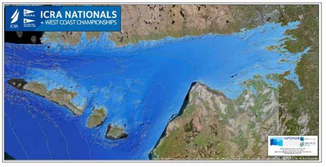
The Galway Bay based Marine Institute has presented competitors in the 54–boat ICRA Cruiser Racer National Championships currently being hosted by Galway Bay Sailing Club with a large A1 sized full colour poster illustrating the seabed imagery of the Bay derived from INFOMAR Mapping, the national seabed mapping programme undertaken jointly by Marine Institute and Geological Survey of Ireland.
Galway Bay is one of the first Irish coastal inlets to have been fully mapped by INFOMAR.
While the data are primarily used for safe navigation and shipping, they also provide invaluable information for fisheries management, environmental conservation, and strategic development programmes.
While as sailors we rely on our admiralty charts, pilot books, and more increasingly on our digital navigation software apps to get us safely around the coast, this modern era of seabed mapping data now enables production of high resolution oceanographic models, and reliably predictive tides and currents.


 pictured here racing on Dublin Bay will compete in the 2024 Jura Scottish Series this month")
 heads out to meet AK Ilen in Clew Bay, County Mayo")
 passes Copper Point Light at Long Island in the first 2024 summer sailing season at Schull Harbour Sailing Club")


 will be going head-to-head with long-lost multi-club-representing sister Two Farr at Howth’s three-day Wave Regatta, starting Friday")


 with his best mate, getting into battle mood in the North African desert during World War II of 1939-45. Anyone who gets along well with a Jack Russell terrier, while looking so very like superstar actor Liam Neeson before Neeson was born, must have had some redeeming features - even if he was a danger to all when partying in a new kitchen")

