Menu

Ireland's sailing, boating & maritime magazine

Dublin Bay Boating News and Information

Displaying items by tag: Coypu

Waterways Ireland advises all users of sightings on the Royal Canal at Ashtown of a large invasive rodent species that is highly damaging to river, lake and canal banks.

As previously reported on Afloat.ie, the coypu — also known as the nutria in the United States — is regarded as a destructive invasive species and pest, posing a threat to agriculture, the stability of river banks and even coastal defences.

The coypu is an EU-regulated species of concern with trade, transport and reproduction restrictions in place (No.1143/2014).

The large river rats can also carry a number of serious diseases communicable to humans and domestic animals.

Waterways Ireland says coypu eradication programmes can cost up to several millions of euro and are not always successful.

Most recently there were sightings of the rodents in Cork city two years ago, after a number were trapped by the National Parks and Wildlife Service (NPWS) in a tributary of the River Lee.

But their presence across the country in the capital raises concerns about their further spread throughout Ireland’s inland waterways.

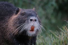
Waterways Ireland has provided a checklist for how to spot a coypu, which are often confused with common otters:

  • Large semi-aquatic rodent up to 1 meter in head to tail length. Features same in juveniles.
  • It can weigh 5-9kg.
  • It has webbed hind feet.
  • Dark fur often with lighter ends and has a white muzzle.
  • Has long cylindrical tail (not fur tail like otter) and small slightly protruding ears.
  • Distinctive features are large bright orange-yellow incisor (front) teeth usually visible.
  • Coypu are generally found near permanent water.

Do not attempt to engage, trap or harm these animals.

Waterways Ireland appeals for the public keep a lookout along the waterways and especially along the Royal Canal at Ashtown, and report sightings (with photos is possible) to any of the following:

For more information visit species.biodiversityireland.ie.

Published in Inland Waterways

#MarineWildlife - Cork residents near the River Lee are urged to be report any sightings of coypu after one of the large rodents was seen in Cork city last week.

The invasive species was released within the last two years in the Curraheen River, a tributary of the Lee, with the National Parks and Wildlife Service (NPWS) trapping 10 of the large river rats since then, according to the Irish Examiner.

But the NPWS now seeks the public’s help in identifying how far beyond the Curraheen they might have spread, with possible sightings on the Cork-Bandon road, at Monkstown on Cork Harbour and in streams north of the city.

The situation is a far cry from two years ago, when fears of a coypu invasion of Ireland’s inland waterways were dismissed upon the news of a single three-foot rodent found in a Tipperary stream, as previously reported on Afloat.ie.

Also known as nutria in the United States, the rodents are regarded as a destructive invasive species and pest, posing a threat to the stability of river banks and even coastal defences.

The Irish Examiner has more on the story HERE.

Published in Marine Wildlife

#MarineWildlife - Rodney is the name given to a giant river rat found swimming in a Tipperary stream last week, as TheJournal.ie reports.

The three-foot rodent is a coypu, native to South America, and is the first of his kind ever found in the wild in Ireland.

After his discovering in a river in Kilnasculy, Rodney is now in the care of the Kildare Animal Foundation Wildlife Unit, whose Dan Donoher believes the animal must have been a kept as a pet before escaping or being released by its owner.

The coypu is better known as the nutria in the United States, where it is regarded as a destructive invasive species and pest, particularly in the southern Gulf Coast region.

But Dononher told RTÉ Radio 1's John Murray Show that there's no fear of a coypu invasion in Ireland's waterways just yet.

Published in Marine Wildlife

Dublin Bay

Dublin Bay on the east coast of Ireland stretches over seven kilometres, from Howth Head on its northern tip to Dalkey Island in the south. It's a place most Dubliners simply take for granted, and one of the capital's least visited places. But there's more going on out there than you'd imagine.

The biggest boating centre is at Dun Laoghaire Harbour on the Bay's south shore that is home to over 1,500 pleasure craft, four waterfront yacht clubs and Ireland's largest marina.

The bay is rather shallow with many sandbanks and rocky outcrops, and was notorious in the past for shipwrecks, especially when the wind was from the east. Until modern times, many ships and their passengers were lost along the treacherous coastline from Howth to Dun Laoghaire, less than a kilometre from shore.

The Bay is a C-shaped inlet of the Irish Sea and is about 10 kilometres wide along its north-south base, and 7 km in length to its apex at the centre of the city of Dublin; stretching from Howth Head in the north to Dalkey Point in the south. North Bull Island is situated in the northwest part of the bay, where one of two major inshore sandbanks lie, and features a 5 km long sandy beach, Dollymount Strand, fronting an internationally recognised wildfowl reserve. Many of the rivers of Dublin reach the Irish Sea at Dublin Bay: the River Liffey, with the River Dodder flow received less than 1 km inland, River Tolka, and various smaller rivers and streams.

Dublin Bay FAQs

There are approximately ten beaches and bathing spots around Dublin Bay: Dollymount Strand; Forty Foot Bathing Place; Half Moon bathing spot; Merrion Strand; Bull Wall; Sandycove Beach; Sandymount Strand; Seapoint; Shelley Banks; Sutton, Burrow Beach

There are slipways on the north side of Dublin Bay at Clontarf, Sutton and on the southside at Dun Laoghaire Harbour, and in Dalkey at Coliemore and Bulloch Harbours.

Dublin Bay is administered by a number of Government Departments, three local authorities and several statutory agencies. Dublin Port Company is in charge of navigation on the Bay.

Dublin Bay is approximately 70 sq kilometres or 7,000 hectares. The Bay is about 10 kilometres wide along its north-south base, and seven km in length east-west to its peak at the centre of the city of Dublin; stretching from Howth Head in the north to Dalkey Point in the south.

Dun Laoghaire Harbour on the southside of the Bay has an East and West Pier, each one kilometre long; this is one of the largest human-made harbours in the world. There also piers or walls at the entrance to the River Liffey at Dublin city known as the Great North and South Walls. Other harbours on the Bay include Bulloch Harbour and Coliemore Harbours both at Dalkey.

There are two marinas on Dublin Bay. Ireland's largest marina with over 800 berths is on the southern shore at Dun Laoghaire Harbour. The other is at Poolbeg Yacht and Boat Club on the River Liffey close to Dublin City.

Car and passenger Ferries operate from Dublin Port to the UK, Isle of Man and France. A passenger ferry operates from Dun Laoghaire Harbour to Howth as well as providing tourist voyages around the bay.

Dublin Bay has two Islands. Bull Island at Clontarf and Dalkey Island on the southern shore of the Bay.

The River Liffey flows through Dublin city and into the Bay. Its tributaries include the River Dodder, the River Poddle and the River Camac.

Dollymount, Burrow and Seapoint beaches

Approximately 1,500 boats from small dinghies to motorboats to ocean-going yachts. The vast majority, over 1,000, are moored at Dun Laoghaire Harbour which is Ireland's boating capital.

In 1981, UNESCO recognised the importance of Dublin Bay by designating North Bull Island as a Biosphere because of its rare and internationally important habitats and species of wildlife. To support sustainable development, UNESCO’s concept of a Biosphere has evolved to include not just areas of ecological value but also the areas around them and the communities that live and work within these areas. There have since been additional international and national designations, covering much of Dublin Bay, to ensure the protection of its water quality and biodiversity. To fulfil these broader management aims for the ecosystem, the Biosphere was expanded in 2015. The Biosphere now covers Dublin Bay, reflecting its significant environmental, economic, cultural and tourism importance, and extends to over 300km² to include the bay, the shore and nearby residential areas.

On the Southside at Dun Laoghaire, there is the National Yacht Club, Royal St. George Yacht Club, Royal Irish Yacht Club and Dun Laoghaire Motor Yacht Club as well as Dublin Bay Sailing Club. In the city centre, there is Poolbeg Yacht and Boat Club. On the Northside of Dublin, there is Clontarf Yacht and Boat Club and Sutton Dinghy Club. While not on Dublin Bay, Howth Yacht Club is the major north Dublin Sailing centre.

© Afloat 2020