Menu

Ireland's sailing, boating & maritime magazine

Inland afloat headers


Displaying items by tag: Bantry
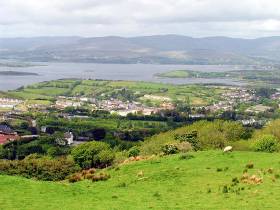
The south-west port of Bantry Bay has not been included in the Port of Cork's major new masterplan, the company confirmed last week.

According to the Southern Star, the Port of Cork Company (PoCC) is planning to share the emerging concepts of the ‘Port Masterplan 2050’ in a series of consultation meetings.

Afloat adds these meetings have taken place in Ringaskiddy, Cork and most recently in Cobh (see related story: By 2030 Port of Cork to vacate city centre).

The port area of Bantry Bay Port Company, which comes under the auspices of PoCC, is however not included in the 'Port Masterplan 2050'

The Masterplan will allow the company to adapt to a shifting landscape in port operations and plan its development as a key global port of the future.

For more on this the newspaper reports.

In addition to a story on a joint venture project (announced in 2021) to build on Whiddy Island a green energy plant. 


Published in Irish Ports

The Bantry inner harbour development scheme has re-generated interest in the West Cork town as a marine leisure and sailing centre. Bantry Bay Port Company, operated by Cork Port, has a sheltered marina with 40 berths there.

But the town centre itself, on the edge of the bay, has suffered a lot from flooding during the past few years.

“It has been severely and repeatedly impacted,” according to Cork County Council which has announced a ‘Public Participation Day’ next week to discuss the flood relief scheme it is planning for the town.

Several factors have caused the problems, including tidal issues, according to Cork County Council CEO, Tim Lucey. “The Bantry Flood Relief Scheme involves the analysis of several very complex factors, including tidal, fluvial and pluvial flood mechanisms. Constraints include environmental factors, cultural and heritage elements, and impacts on existing infrastructure.”

The ‘Public Participation Day’ will be held in the Council offices in the town centre - Áras Beanntraí - at Wolfe Tone Square next Wednesday, May 18, between 4 and 8 p.m.

This is to assess public opinion about the scheme, the first stage of which involves a detailed study of flooding mechanisms in Bantry and its environs, involving data collection, site investigation, hydraulic and hydrological assessment, and public consultation. Presentations will be given by the project team to identify a preferred option.

“It is an opportunity for the public and business people to share their experience of flooding in Bantry, submit comments and make their views known,” said County Cork Mayor Gillian Coughlan. “The scheme will provide critical infrastructure to protect Bantry against significant flood events in the future. Different options will be assessed and the most appropriate solutions brought to planning stage.”

Published in West Cork
Tagged under

Fisheries Local Action Groups (FLAGs) from across Europe will be meeting in Bantry next month to discuss “smart” ways to tackle coastal challenges.

The Smart Coastal Areas seminar, hosted by FLAG South and Bord Iascaigh Mhara at the Westlodge Hotel from Tuesday 2 to Thursday 4 April, aims to provide ideas and guidance on ‘smart’ development — including activities, development models and ways of working to boost the fisheries industry and coastal regions in an innovative way.

In 2017, the GDP of the Irish seafood sector was estimated at €1.15 billion. More than 14,000 people are employed in Ireland’s seafood sector, many of whom work and live in rural coastal communities.

Fisheries and coastal areas are impacted by factors such as depopulation, ageing population, climate change and economic decline.

The EU’s European Maritime and Fisheries Fund (EMFF) was set up to support initiatives by local fisheries communities through Community-Led Local Development (CLLD). FLAGs can use this money to implement projects that support sustainable small-scale fisheries and aquaculture production, and coastal communities.

However, funding is not the only answer, as creativity and strategic action is also needed.

The Smart Coastal Areas seminar will highlight:

  • Smart partnerships (creating win-win situations between different interest groups)
  • Smart resource use (optimising local resources and production systems)
  • Smart financing (reaching small-scale beneficiaries: micro-credit, etc)
  • Smart services (adapting services to ensure their viability: smart harbours, connecting remote areas, etc)

The seminar will include presentations on FLAG projects in EU countries that demonstrate smart approaches to rural sustainability and development. Local examples from the Cork coast are Courtmacsherry Community Shop and Schull Bait Bins, both supported by Ireland’s FLAG South.

Also included with the seminar will be a field visit to local fisheries-related businesses as well as Whiddy Island to view the progress of a tourism-related project.

Published in Coastal Notes

11 International teams will make Antrim their home for the International Contest of Seamanship tomorrow.

As Afloat.ie reported previously in March, 200 young people from USA, Russia, St Petersburg, Belgium, Ghent, GB, Ireland, Quebec, France, Denmark, Canada and Northern Ireland will compete, live and learn together.

During the week long contest the 38ft wooden gigs will be sailed and rowed. Teams will undertake various skill tests, including navigation, rope work, Jack Stay Transfer, Captain’s Gig, Slalom and Man overboard rescue.

Spectators will have a great view from the Lough Shore of the 11 picturesque gigs as they race on Lough Neagh.

The contest takes place every two years and Northern Ireland has competed in Canada, Finland, Ireland, Italy, France and Denmark in 2016.

"The Challenge for the crew is to learn to sail and row a 38ft Captain’s gig and use it in friendly contests"

The Challenge for the crew is to learn to sail and row a 38ft Captain’s gig and use it in friendly contests, including the biennial contest of seamanship with young people of other nations. To build a team that makes new friendships, new understanding and builds trust that spans frontiers. Also to be ambassadors among people of other nations, competing overseas in one of the member nations.

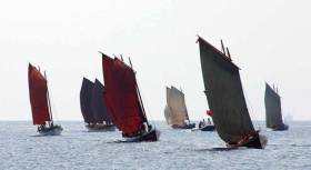
The gigs are replicas if 18th-century admiral’s barges, used by fleets in harbour for transport between ships and shore. The design was drawn from a French naval model, but such boats were common two centuries ago to the navies of Britain, France, Russia Spain and Sweden. Technically they are long boats but common usage and history have led Atlantic Challenge to use the term “gigs” or “Bantries. The model from which they are built dates from the French invasion of Ireland at Bantry in 1796.

Northern Ireland has had 2 gigs Harmonie was launched in 2003 by Dame Mary Peters and the crew are now sailing Cwch John Kerr, named after the boat builder credited with bringing the organisation to the UK.

We are a cross community, cross gender organisation, giving equal prominence to all individuals in our team. We welcome applicants from all corners of Northern Ireland. Our gig Cwch John Kerr is based at Antrim Boat Club on Lough Neagh.

Northern Ireland became World Champions in 2012.

Dame Mary Peters is our Patron and will open the International contest in Clotsworthy Gardens.

The contest will start in earnest this Saturday morning, with at least two races or tasks every day for the week. This is a strong test of the crew’s physical strength and endurance as well as requiring teamwork, quick thinking and ingenuity. All teams striving to be World Champions.

The experience of mastering the gigs, living with people from other cultures and learning new skills is life-changing for the young people. They grow in confidence, life experience and make new friends. The experience of the contests is something the crews will never forget.

It is an honour for Antrim Boat Club to be chosen to host this Contest. The visitors are all looking forward to enjoying the welcome, sights and traditions of Northern Ireland.
The Northern Ireland crew is made up of approx. 20 young people from the local area, Antrim, Randalstown, Doagh and Templepatrick with previous crew returning from Glasgow, New Zealand and Guernsey for this important contest. Under the expert supervision of Michael Patton the cox, the crew have been training every Sunday at Antrim Boat Club to prepare for the contest. 

The opening ceremony will take place in Clotsworthy Gardens at 4:00 on Friday 20th July 2018. Everyone is welcome to view the teams and contest. 

Published in Historic Boats
Tagged under

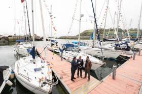
#Tourism - The Port of Cork, Bantry Bay Port Company and the Royal Cork Yacht Club are joining forces to promote marine leisure in Cork at the Southampton Boat Show.

The three organisations are in attendance at Stand J047 from today Friday 15 to Sunday 24 September tasked with promoting their marina facilities to potential visitors.

They will also be targeting the luxury cruisers and motor yacht market to entice further calls to Cork, Crosshaven and Bantry.

In 2009 the Port of Cork implemented the Leisure and Recreation Strategy for Cork Harbour, with the primary focus of the strategy on water-based leisure and recreational activities in and around the harbour.

Speaking about attending the boat show, Sara Mackeown, commercial marketing executive for the Port of Cork, said: “This is great opportunity to showcase Cork as an ideal destination for marine leisure users.

“Our marina facility in the heart of Cork City is unique and having just completed the new Bantry Harbour Marina there is a great connection now between Cork and West Cork. We are delighted to work closely with the Royal Cork Yacht Club, who have huge experience in the field.”

Cork Harbour offers significant potential for further development of the marine recreation sector as an important source of enjoyment and economic gain for the local residents and visitors, and it is anticipated that attending the Southampton Boat Show will help to promote the marine facilities directly to the desired market.

Gavin Deane, general manager of the Royal Cork Yacht Club said: “The Royal Cork Yacht Club are delighted to be collaborating with both the Port of Cork and Bantry Bay Port Company in promoting the region.

“This year we have seen a significant increase in the number of visiting boats to our marina, the majority of whom have travelled from the south coast of the UK.

“We feel that with this growth in visitors, now is the ideal time to showcase everything that Cork has to offer and Southampton Boat Show 2017 is the place to do it.”

Published in Aquatic Tourism

#portofcork – The Port of Cork today outlined plans for Phase 1 of the Bantry Inner Harbour Development which the Port of Cork will undertake on behalf of its subsidiary company, Bantry Bay Port Company.

The scheme marks the start of the regenerating of the inner harbour and is in keeping with the total Inner Harbour Development scheme which was developed by the Bantry Bay Harbour Commissioners in 2012 and planning permission was granted in 2013.

Now being advanced by the Bantry Bay Port Company, the scheme will provide a more sheltered harbour environment and marina with increased water depth and improved pier facilities which will promote fishing and tourism activities in the Bantry area.

Phase 1, which is likely to cost €8.5m, will consist of the following principal elements:
· 20 berth Marina (quayside pontoons)

· Dredging to a depth of 4 metres to allow vessels access to the inner harbour

· Remedial works to Town Pier (widening and extending)

· 4,000m2 of reclaimed landscaped amenity area

· Construction of 60m long floating breakwater pontoon

· Beach nourishment at Cove site

Commenting on the development, Brendan Keating, Chief Executive of the Port of Cork said that there are many benefits for Bantry and the wider Harbour area in undertaking such a project. "Works to the Town Pier will ensure improved longevity of the existing pier structure and improved access and facilities on the pier will facilitate existing activities and hopefully generate more commercial activity for Bantry Harbour. There will be improved berthage available for larger marine vessels and the Company would hope that this will lead to an upturn in marine leisure in and around Bantry Harbour" he said.

It is expected that construction will commence on the project in Q4 2015 and will be complete in Q1 2017. The work will be phased in order to minimise impacts to pier operations and to minimise traffic and amenity impacts for the town.

Bantry Bay is the largest of the long marine inlets in south-west Ireland. It is approximately 35 km long, running in a south-west to north-easterly direction. The entrance to the bay is approximately 10 km wide, steadily narrowing to 3-4 km at its head. Bere Island, situated on the north shore adjacent to CastletownBere, and Whiddy Island lying near the head of the bay on the southern shore are the two largest islands in the bay.

Published in Port of Cork
Tagged under

#maritimefestival – There will be a number of maritime themed events at the 2014 West Cork Literary Festival in Bantry, Co. Cork which runs from Monday, July 7th to Friday, July 11th with many free events.

On Friday July 11th in Bantry Library Rose George, the winner of the 2013 Mountbatten Maritime Award for Best Literary Contribution, will give a free talk about her fascinating journey into the hidden world of shipping. Her pursuit of the shadowy truths behind the industry that brings us almost everything we eat, wear, and work with, took her across the globe. "Deep Sea and Foreign Going: Inside Shipping, the Invisible Industry that Brings You 90% of Everything" is essential reading for anyone curious about the complex systems behind our convenient modern world. She follows the routes travelled by mercantile and naval fleets, pirate gangs, and illegal floating factories.

Philip Hoare will read from his yearlong adventure through the world's oceans. "The Sea Inside" on Thursday, July 10th. In colourful prose and lively line drawings, he sets out to rediscover the sea and its islands, birds, and beasts. Starting at his home on the shores of Britain's Southampton Water and moving in ever widening circles—like the migration patterns of whales—Hoare explores London, the Isle of Wight, the Azores, Sri Lanka, Tasmania, and New Zealand. Philip, winner of the 2009 Samuel Johnson Prize for non-fiction, is a broadcaster and author, he wrote and presented the BBC Arena film, "The Hunt for Moby-Dick", and directed three films for BBC's Whale Night.

On Saturday, July 12th there will be a special event on Whiddy Island, starting with the ferry across we celebrate Bantry Bay, the sea beyond and the lore and poetry of West Cork. John Mack, author of "The Sea: A Cultural History" draws on histories, maritime archaeology, art history and great literature to provide an innovative account of the great blue yonder and his own love for Whiddy. Philip Hoare will read from "Leviathan or, The Whale" his award winning book and film, which is also the story of our own obsessions. Leanne O'Sullivan from the Beara Peninsula will read from her poetry collections "Cailleach, The Hag of Beara" and "The Mining Road". She is the recipient of The Rooney Ireland Chair of Poetry Bursary and Lawrence O'Shaughnessy Awards.

Of course, younger readers are looked after too with the interactive Monster Sea Doodle! Travel 50 leagues under the sea with Captain Olivia Golden, illustrator extraordinaire, and learn how to draw some of the creatures that tickle, wriggle and swim in the salt water off the Bantry coast. Monster Sea Doodle! Takes place on Tuesday, July 8th, in St Brendan's School Hall

Ben Okri, Jonathan Miller, Blake Morrison, Karen Joy Fowler and Jennifer Johnston are just some of the guests announced for the renowned West Cork Literary Festival this July. The West Cork Literary Festival runs from July 6th to 12th and is generously supported by The Arts Council, Cork County Library and Arts Service and Fáilte Ireland. Booking on www.westcorkliteraryfestival.ie, Telephone: 027 52788/9 

Published in Maritime Festivals

#TALL SHIPS - The flagship vessel for an Asgard-type sail training programme in Cork has been locked up in a boatyard since 2007, the Irish Examiner reports.

The Omar B was supposed to be the focus of a Youthreach project based in Bantry for early school leavers. But the schooner has spent the last four-plus years in storage in Baltimore, and has been deteriorating due to lack of maintenance - despite the scheme still notionally running, the newspaper report says.

Five two-man dinghies purchased with grant money have also reportedly spent most of 2011 in storage.

Co Cork's VEC has now put the €150,000 sailing programme under review following concerns over storage costs and lack of direction for the project.

The 75ft Omar B was donated to the CCVEC by owner and builder Don Attig in 2003 and refitted for use by students thanks to generous voluntary funding. Attig said the boat was of immense benefit to students who would not otherwise be in education.

The Irish Examiner has much more on the story HERE.

Published in Tall Ships

Lifeboat crew with Castletownbere RNLI launched this afternoon (Tuesday 21 December 2010) at 3.30pm to transfer a man from Bere Island to Bantry in West Cork after he was injured in a fall.  The lifeboat crew had to step in after heavy snows made the roads in Bantry impassable and stopped the ferry running.

The man in his thirties was transferred onto the lifeboat at Bere Island and brought to Bantry to be met by a waiting fire brigade.  The casualty was then brought to hospital for treatment.  Conditions at sea were fair but with a very heavy snow falling.

Commenting on the callout Deputy Second Coxswain Paul Stevens said, "This was a callout in very challenging conditions.  Due to the heavy snowfall in West Cork the roads in some places are impassable and travel is very difficult.  We were delighted to be able to help out and ensure that the man was transferred quickly to receive emergency treatment.  Our lifeboats are there to save lives wherever we can."

Related Safety posts

RNLI Lifeboats in Ireland


Safety News


Rescue News from RNLI Lifeboats in Ireland


Coast Guard News from Ireland


Water Safety News from Ireland

Marine Casualty Investigation Board News

Marine Warnings

Published in RNLI Lifeboats

General Information on using Waterways Ireland inland navigations

Safety on the Water

All users of the navigations are strongly recommended to make themselves aware of safety on the water for whatever activity they are involved in and to read the advice offered by the various governing bodies and by:

The Dept. of Transport, Ireland: www.gov.ie/transport and The Maritime and Coastguard Agency, UK, The RNLI – Water Safety Ireland for information in terms of drowning prevention and water safety.

Registration of Vessels

All vessels using the Shannon Navigation, which includes the Shannon-Erne Waterways and the Erne System must be registered with Waterways Ireland. Only open undecked boats with an engine of 15 horsepower or less on the Shannon Navigation, and vessels of 10 horsepower or less on the Erne System, are exempt. Registration is free of charge.

Craft registration should be completed online at: https://www.waterwaysireland.org/online-services/craft-registration

Permits for use of the Grand and Royal Canals and the Barrow Navigation

All vessels using the Grand and Royal Canals and the Barrow Navigation must display appropriate valid Permit(s) i.e A Combined Mooring and Passage Permit (€126) and if not intending to move every five days, an Extended Mooring Permit (€152).

Permit applications should be completed online at: https://www.waterwaysireland.org/online-services/canal-permits

Passage on the Royal and Grand Canals – Dublin Area

For boat passage through the locks east of Lock 12 into / out of Dublin on either the Royal or Grand Canals, Masters are requested to contact the Waterways Ireland Eastern Regional Office (M-F 9.30am-4.30pm) on tel: +353(0)1 868 0148 or email [email protected] prior to making passage in order to plan the necessary lock-keeping assistance arrangements.

On the Grand Canal a minimum of two days notice prior to the planned passage should be given, masters should note that with the exception of pre-arranged events, a maximum of 2 boats per day will be taken through the locks, travelling either east or west.

Movements in or out of the city will be organised by prior arrangement to take place as a single movement in one day. Boaters will be facilitated to travel the system if their passage is considered to be safe by Waterways Ireland and they have the valid permit(s) for mooring and passage.

Newcomen Lifting Bridge

On the Royal Canal two weeks’ notice of bridge passage (Newcomen Lifting Bridge) is required for the pre-set lift date, and lock assistance will then also be arranged. A minimum of 2 boats is required for a bridge lift to go ahead.

Waterways Ireland Eastern Regional Office (Tel: +353(0)1 868 0148 or [email protected] ) is the point of contact for the bridge lift.

A maximum number of boats passing will be implemented to keep to the times given above for the planned lifts (16 for the Sat / Sun lifts & 8 for the weekday lifts). Priority will be given on a first come first served basis.

On day of lift, boaters and passengers must follow guidance from Waterways Ireland staff about sequence of passage under bridge & through Lock 1, and must remain within signed and designated areas.

Events Held on the Waterways

All organised events taking place on the waterways must have the prior approval of Waterways Ireland. This is a twelve week process and application forms must be accompanied with the appropriate insurance, signed indemnity and risk assessment. The application should be completed on the Waterways Ireland events page at :

https://www.waterwaysireland.org/online-services/event-approval

Time Limits on Mooring in Public Harbours

On the Shannon Navigation and the Shannon-Erne Waterway craft may berth in public harbours for five consecutive days or a total of seven days in any one month.

On the Erne System, revised Bye Laws state that: No master or owner shall permit a vessel, boat or any floating or sunken object to remain moored at or in the vicinity of any public mooring, including mooring at any other public mooring within 3 kilometres of that location, for more than 3 consecutive days and shall not moor at that same mooring or any other public mooring within 3 kilometres of that location within the following 3 consecutive days without prior permission by an authorised official.

Winter Mooring on the Shannon Navigation and Shannon Erne Waterway

Winter mooring may be availed of by owners during the period 1 Nov to 31 Mar by prior arrangement and payment of a charge of €63.50 per craft. Craft not availing of Winter Mooring must continue to comply with the “5 Day Rule”. Winter Mooring applications should be completed online at : https://www.waterwaysireland.org/online-services/winter-moorings-booking

Owners should be aware that electricity supply and water supply to public moorings is disconnected for the winter months. This is to protect against frost damage, to reduce running costs and to minimise maintenance requirements during the winter months.

Vessel owners are advised that advance purchasing of electricity on the power bollards leading up to the disconnection date should be minimal. Electricity credit existing on the bollards will not be recoverable after the winter decommissioning date. Both services will be reinstated prior to the commencement of the next boating season.

Smart Cards

Waterways Ireland smart cards are used to operate locks on the Shannon Erne Waterway, to access the service blocks, to use the pump-outs along the navigations, to avail of electrical power at Waterways Ireland jetties.

Berthing in Public Harbours

Masters are reminded of the following:

  • Equip their vessel with mooring lines of appropriate length and strength and only secure their craft to mooring bollards and cleats provided for this purpose.
  • Ensure the available berth is suitable to the length of your vessel, do not overhang the mooring especially on finger moorings on floating pontoon moorings.
  • Ensure mooring lines, electric cables and fresh water hoses do not create a trip hazard on public jetties for others users.
  • Carry sufficient fenders to prevent damage to your own vessel, other vessels and WI property.
  • Allow sufficient space between your vessel and the vessel ahead /astern (c.1m) for fire safety purposes and /or to recover somebody from the water.
  • Do not berth more than two vessels side by side and ensure there is safe access/egress at all times between vessels and onto the harbour itself.
  • Do not berth in such a way to prevent use of harbour safety ladders, slipways or pump-outs.
  • Do not allow the bow of your vessel to overhang the walkway of a floating mooring thus creating a hazard for others with an overhanging anchor or bow fendering.
  • Animals are not allowed to be loose or stray at any time.
  • Harbour and jetty infrastructure such as railings, power pedestals, fresh water taps, electric light poles, safety bollards, ladders etc are not designed for the purpose of mooring craft , they will not bear the strain of a vessel and will be damaged.
  • At Carrybridge on the Erne System, Masters of vessels are not permitted to use stern on mooring. Masters of vessels must use the mooring fingers for mooring of vessels and for embarkation / disembarkation from vessels.

Passenger Vessel Berths

Masters of vessels should not berth on passenger vessel berths where it is indicated that an arrival is imminent. Passenger vessels plying the navigations generally only occupy the berths to embark and disembark passengers and rarely remain on the berths for extended periods or overnight.

Lock Lead-in Jetties

Lead-in jetties adjacent to the upstream and downstream gates at lock chambers are solely for the purpose of craft waiting to use the lock and should not be used for long term berthing.

Vessel Wake

Vessel wake, that is, the wave generated by the passage of the boat through the water, can sometimes be large, powerful and destructive depending on the hull shape and engine power of the vessel. This wake can be detrimental to other users of the navigation when it strikes their craft or inundates the shoreline or riverbank. Masters are requested to frequently look behind and check the effect of their wake / wash particularly when passing moored vessels, on entering harbours and approaching jetties and to be aware of people pursuing other activities such as fishing on the riverbank.

Speed Restriction

A vessel or boat shall not be navigated on the Shannon Navigation at a speed in excess of 5 kph when within 200 metres of a bridge, quay, jetty or wharf, when in a harbour or canal or when passing within 100 metres of a moored vessel or boat.

Vessels navigating the Shannon-Erne Waterway should observe the general 5 kph speed limit which applies along the waterway. This is necessary in order to prevent damage to the banks caused by excessive wash from vessels.

Vessels navigating the Erne System should observe the statutory 5kt / 6mph / 10kph speed limit areas.

A craft on the Royal and Grand canals shall not be navigated at a speed in excess of 6km per hour.

A craft on the Barrow Navigation shall not be navigated at a speed in excess of 11km per hour except as necessary for safe navigation in conditions of fast flow.

Bank Erosion

Narrow sections of all the navigations are particularly prone to bank erosion due to the large wash generated by some craft. Masters are requested to be vigilant and to slow down to a speed sufficient to maintain steerage when they observe the wash of their craft inundating the river banks.

Unusual Waterborne Activity

Unusual waterborne vessels may be encountered from time to time, such as, hovercraft or amphibious aircraft / seaplanes. Masters of such craft are reminded to apply the normal “Rule of the Road” when they meet conventional craft on the water and to allow extra room to manoeuvre in the interest of safety.

Sailing Activity

Mariners will encounter large numbers of sailing dinghies from late June to August in the vicinity of Lough Derg, Lough Ree and Lower Lough Erne. Sailing courses are marked by yellow buoys to suit weather conditions on the day. Vessels should proceed at slow speed and with due caution and observe the rules of navigation when passing these fleets, as many of the participants are junior sailors under training.

Rowing

Mariners should expect to meet canoes and vessels under oars on any part of the navigations, but more so in the vicinity of Athlone, Carrick-on-Shannon, Coleraine, Enniskillen and Limerick. Masters are reminded to proceed at slow speed and especially to reduce their wash to a minimum when passing these craft as they can be easily upset and swamped due to their very low freeboard and always be prepared to give way in any given traffic situation.

Canoeing

Canoeing is an adventure sport and participants are strongly recommended to seek the advice of the sport’s governing bodies i.e Canoeing Ireland and the Canoe Association of Northern Ireland, before venturing onto the navigations.

Persons in charge of canoes are reminded of the inherent danger to these craft associated with operating close to weirs, sluice gates, locks and other infrastructure particularly when rivers are in flood and large volumes of water are moving through the navigations due to general flood conditions or very heavy localised precipitation e.g. turbulent and broken water, stopper waves. Shooting weirs is prohibited without prior permission of Waterways Ireland.

Canoeists should check with lockkeepers prior entering a lock to ensure passage is done in a safe manner. Portage is required at all unmanned locks.

Canoe Trail Network – "Blueways"

Masters of powered craft are reminded that a canoe trail network is being developed across all navigations and to expect more organised canoeing along these trails necessitating slow speed and minimum wash when encountering canoeists, rowing boats etc

Rockingham and Drummans Island Canals – Lough Key

It is expected that work on Rockingham and Drummans Island Canals on Lough Key will be completed in 2021. Access to these canals will be for non-powered craft only, eg canoes, kayaks, rowing boats.

Fast Powerboats and Personal Watercraft (Jet Skis)

Masters of Fast Powerboats (speed greater than 17kts) and Personal Watercraft (i.e.Jet Skis) are reminded of the inherent dangers associated with high speed on the water and especially in the confines of small bays and narrow sections of the navigations. Keeping a proper look-out, making early alterations to course and /or reducing speed will avoid conflict with slower vessels using the navigation. Personal Watercraft are not permitted to be used on the canals.

Towing Waterskiers, Wakeboarders, Doughnuts etc

Masters of vessels engaged in any of these activities are reminded of the manoeuvring constraints imposed upon their vessel by the tow and of the added responsibilities that they have to the person(s) being towed. These activities should be conducted in areas which are clear of conflicting traffic. It is highly recommended that a person additional to the master be carried to act as a “look-out” to keep the tow under observation at all times.

Prohibition on Swimming

Swimming in the navigable channel, particularly at bridges, is dangerous and is prohibited due to the risk of being run over by a vessel underway in the navigation.

Age Restrictions on operating of powered craft

In the Republic of Ireland, Statutory Instrument 921 of 2005 provides the legal requirements regarding the minimum age for operating of powered craft. The Statutory Instrument contains the following requirements:

- The master or owner of a personal watercraft or a fast power craft shall take all reasonable steps to ensure that a person who has not attained the age of 16 years does not operate or control the craft

- The master or owner of a pleasure craft powered by an engine with a rating of more than 5 horse power or 3.7 kilowatts shall take all reasonable steps to ensure that a person who has not attained the age of 12 years does not operate or control the craft.

Lifejackets and Personal Flotation Devices (PFDs)

Lifejackets and PFD’s are the single most important items of personal protective equipment to be used on a vessel and should be worn especially when the vessel is being manoeuvred such as entering / departing a lock, anchoring, coming alongside or departing a jetty or quayside.

In the Republic of Ireland, Statutory Instrument 921 of 2005 provides the legal requirements regarding the wearing of Personal Flotation Devices. The Statutory Instrument contains the following requirements:

- The master or owner of a pleasure craft (other than a personal watercraft) shall ensure, that there are, at all times on board the craft, sufficient suitable personal flotation devices for each person on board.

- A person on a pleasure craft (other than a personal watercraft) of less than 7 metres length overall shall wear a suitable personal flotation device while on board an open craft or while on the deck of decked craft, other than when the craft is made fast to the shore or at anchor.

- The master or owner of a pleasure craft (other than a personal watercraft) shall take all reasonable steps to ensure that a person who has not attained the age of 16 years complies with paragraph above.

- The master or owner of a pleasure craft (other than a personal watercraft), shall take all reasonable steps to ensure that a person who has not attained the age of 16 years wears a suitable personal flotation device while on board an open craft or while on the deck of a decked craft other than when it is made fast to the shore or at anchor.

- The master or owner of a pleasure craft (other than a personal watercraft) shall take all reasonable steps to ensure that a person wears a suitable personal flotation device, at all times while – (a) being towed by the craft, (b) on board a vessel or object of any kind which is being towed by the craft.

Further information is available at: http://www.irishstatutebook.ie/eli/2005/si/921/made/en/print

Firing Range Danger Area – Lough Ree

The attention of mariners is drawn to the Irish Defence Forces Firing Range situated in the vicinity of buoys No’s 2 and 3, on Lough Ree on the Shannon Navigation. This range is used regularly for live firing exercises, throughout the year, all boats and vessels should stay clear of the area marked with yellow buoys showing a yellow "X" topmark and displaying the word "Danger".

Shannon Navigation, Portumna Swing Bridge Tolls

No attempt should be made by Masters’ of vessels to pay the bridge toll while making way through the bridge opening. Payment will only be taken by the Collector from Masters when they are secured alongside the jetties north and south of the bridge.

Navigating from Killaloe to Limerick on the Shannon Navigation

The navigation from Killaloe to Limerick involves passage through Ardnacrusha locks, the associated headrace and tailrace and the Abbey River into Limerick City. Careful passage planning is required to undertake this voyage. Considerations include: lock passage at Ardnacrusha, water flow in the navigation, airdraft under bridges on Abbey River in Limerick, state of tide in Limerick

Users are advised to contact the ESB Ardnacrusha hydroelectric power station (00353 (0)87 9970131) 48 hours in advance of commencing their journey to book passage through the locks at Ardnacrusha. It is NOT advised to undertake a voyage if more than one turbine is operating (20MW), due to the increased velocity of flow in the navigation channel, which can be dangerous. To ascertain automatically in real time how many turbines are running, users can phone +353 (0)87 6477229.

For safety reasons the ESB has advised that only powered craft with a capacity in excess of 5 knots are allowed to enter Ardnacrusha Headrace and Tailrace Canals.

Passage through Sarsfield Lock should be booked on +353-87-7972998, on the day prior to travel and it should be noted also that transit is not possible two hours either side of low water.

A Hydrographic survey in 2020 of the navigation channel revealed that the approach from Shannon Bridge to Sarsfield Lock and the Dock area has silted up. Masters of vessels and water users are advised to navigate to the Lock from Shannon bridge on a rising tide one or two hours before High Tide.

Lower Bann Navigation

The attention of all users is drawn to the “Users Code for the Lower Bann”, in particular to that section covering “Flow in the River” outlining the dangers for users both on the banks and in the navigation, associated with high flow rates when the river is in spate. Canoeists should consult and carry a copy of the “Lower Bann Canoe Trail” guide issued by the Canoe Association of Northern Ireland. Users should also contact the DfI Rivers Coleraine, who is responsible for regulating the flow rates on the river, for advisory information on the flow rates to be expected on any given day.

DfI Rivers Coleraine. Tel: 0044 28 7034 2357 Email: [email protected]

Lower Bann Navigation – Newferry – No wake zone

A No Wake Zone exists on the Lower Bann Navigation at Newferry. Masters of vessels are requested to proceed at a slow speed and create no wake while passing the jetties and slipways at Newferry.

Overhead Power Lines (OHPL) and Air draft

All Masters must be aware of the dangers associated with overhead power lines, in particular sailing vessels and workboats with cranes or large air drafts. Voyage planning is a necessity in order to identify the location of overhead lines crossing the navigation.

Overhead power line heights on the River Shannon are maintained at 12.6metres (40 feet) from Normal Summer level for that section of navigation, masters of vessels with a large air draft should proceed with caution and make additional allowances when water levels are high.

If a vessel or its equipment comes into contact with an OHPL the operator should NOT attempt to move the vessel or equipment. The conductor may still be alive or re-energise automatically. Maintain a safe distance and prevent third parties from approaching due to risk of arcing. Contact the emergency services for assistance.

Anglers are also reminded that a minimum ground distance of 30 metres should be maintained from overhead power lines when using a rod and line.

Submarine Cables and Pipes

Masters of vessels are reminded not to anchor their vessels in the vicinity of submarine cables or pipes in case they foul their anchor or damage the cables or pipes. Look to the river banks for signage indicating their presence.

Water Levels - Precautions

Low Water Levels:

When water levels fall below normal summer levels masters should be aware of:

Navigation

To reduce the risk of grounding masters should navigate on or near the centreline of the channel, avoid short cutting in dog-legged channels and navigating too close to navigation markers.

Proceeding at a slow speed will also reduce “squat” effect i.e. where the vessel tends to sit lower in the water as a consequence of higher speed.

Slipways

Reduced slipway length available under the water surface and the possibility of launching trailers dropping off the end of the concrete apron.

More slipway surface susceptible to weed growth requiring care while engaged in launching boats, from slipping and sliding on the slope. Note also that launching vehicles may not be able to get sufficient traction on the slipway once the craft is launched to get up the incline.

Bank Erosion

Very dry riverbanks are more susceptible to erosion from vessel wash.

Lock Share

Maximising on the number of vessels in a lock will ensure that the total volume of water moving downstream is decreased. Lock cycles should be used for vessels travelling each way.

High Water Levels:

When water levels rise above normal summer level masters should be aware of:

Navigation

Navigation marks will have reduced height above the water level or may disappear underwater altogether making the navigable channel difficult to discern.

In narrow sections of the navigations water levels will tend to rise more quickly than in main streams and air draft at bridges will likewise be reduced.

There will also be increased flow rates particularly in the vicinity of navigation infrastructure such as bridges, weirs, locks etc where extra care in manoeuvring vessels will be required.

Harbours and Jetties

Due care is required in harbours and at slipways when levels are at or near the same level as the harbour walkways' as the edge will be difficult to discern especially in reduced light conditions. It is advised that Personal Flotation Devices be worn if tending to craft in a harbour in these conditions.

Slipways

Slipways should only be used for the purpose of launching and recovering of water craft or other objects from the water. Before using a slipway it should be examined to ensure that the surface has sufficient traction/grip for the intended purpose such as launching a craft from a trailer using a vehicle, that there is sufficient depth of water on the slipway to float the craft off the trailer before the concrete apron ends and that the wheels of the trailer do not drop off the edge of the slipway. That life-saving appliances are available in the vicinity, that the vehicle is roadworthy and capable of coping with the weight of the trailer and boat on the incline. It is recommended that slipway operations are conducted by two persons.

Caution to be Used in Reliance upon Aids to Navigation

The aids to navigation depicted on the navigation guides comprise a system of fixed and floating aids to navigation. Prudent mariners will not rely solely on any single aid to navigation, particularly a floating aid to navigation. With respect to buoys, the buoy symbol is used to indicate the approximate position of the buoy body and the ground tackle which secures it to the lake or river bed. The approximate position is used because of the practical limitations in positioning and maintaining buoys in precise geographical locations. These limitations include, but are not limited to, prevailing atmospheric and lake/river conditions, the slope of and the material making up the lake/river bed, the fact that the buoys are moored to varying lengths of chain, and the fact that the buoy body and/or ground tackle positions are not under continuous surveillance. Due to the forces of nature, the position of the buoy body can be expected to shift inside and outside the charted symbol.

Buoys and perches are also moved out of position or pulled over by those mariners who use them to moor up to instead of anchoring. To this end, mariners should always monitor their passage by relating buoy/perch positions with the published navigation guide. Furthermore, a vessel attempting to pass close by always risks collision with a yawing buoy or with the obstruction that the buoy or beacon/perch marks.

Masters of Vessels are requested to use the most up to date Navigation guides when navigating on the Inland Waterways.

Information taken from Special Marine Notice No 1 of 2023