


#MarineNotice - Shell E&P Ireland were scheduled to commence flowline installation works between two existing subsea wells at the Corrib gas field this week.
This work will be followed by placement of rock protection along the length of the exposed flowline between the two wells.
There may also be some additional rock placement along the pipeline corridor from the offshore field to the landfall at Broadhaven Bay.
The works, due to commence during this last week of July, are expected run for 30 to 40 days.
The first phase of works will all take place within the 500m Safety Zone surrounding the wells P2 and P5, and along the corridor between P2 and P5.
Carried out by the Skandi Neptune (callsign 2HMG8), the work involves the lay of a new flowline between the two wells followed by connection at each end and pressure testing.
Final seabed connections will be completed on the existing seabed control umbilical followed by the commissioning of the P2 well control system.
This work is expected to be completed by mid August, after whic the Nordnes (callsign PHOG) will commence the second-phase rock placements.
The guard vessel Glomar Arctic (callsign H09083) will be on location in the Corrib Field for the duration of the project. Radio warnings will be given to all marine traffic in the
immediate area. All the vessels will be listening on VHF Channel 16 throughout the project.
Details of co-ordinates of the relevant work areas are included in Marine Notice No 29 of 2016, a PDF of which is available to read or download HERE.
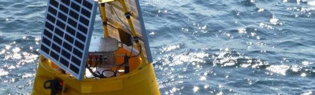
Meanwhile, TechWorks Marine were scheduled to deploy two temporary buoys in the Shannon Estuary on Friday 29 July.
The buoys are required for the placement of turbidity sensors before and during a dredge campaign, and will be in place for the next four weeks.
These data buoys, deployed on a single point mooring, are 1.2m wide, are yellow in colour and have a yellow navigation light with a 2nm range, with five flashes every 20 seconds.
Co-ordinates are included in Marine Notice No 30 of 2016, a PDF of which is available to read or download HERE.


 helicopter and fixed-wing aviation")
")


 John Stapleton, Robbie Quinn and Helm Alan Goucher")


 Michael Murphy Schull Harbour Sailing Club (SHSC), Eric Coogan Heineken Ireland, Mark Murphy, Commodore SHSC, Jack Allen SHSC, Carmel O'Regan SHSC, Cornelious Ndlovu, Schull Harbour Hotel Operations Manager and Derval Murphy SHSC")


