


This is Public Consultation Week for the First Review of Dublin Port’s Development Masterplan 2012-2040, and with a 28-year timespan involved, some of the more remote yet very possible proposals will still seem at the very least far-fetched - and at worst outrageous - to residents and harbour users most directly affected writes W M Nixon.
You’ll need to get your skates on if you’re going to see how the port is presenting its proposals in the neighbourhoods most directly involved, as the Clontarf session today (Monday 13th February) in Scoil Ui Chonaill GAA was due to conclude at 8.0pm. Tomorrow being St Valentine’s Day, everyone will be otherwise occupied as Dublin is a a city of incurable romantics, but the show resumes on Wednesday 15th February from 2.0pm to 8.0pm at the Sean O’Casey Community Centre, St Mary’s Road, East Wall Road, Dublin 3.
However, it’s the concluding show on Thursday 16th February, again from 2.0pm to 8.0pm, which is likely to attract most sparks, as it’s in Clanna Gael Fontenoy GAA Club, Sean Moore Road, Ringsend, Dublin 4, and it’s the Dublin communities of Ringsend, Irishtown and Sandymount – all in Dublin 4 - which would see some of the more far-fetched proposals having greatest impact.
From a visit to the Clontarf presentation today (Monday) it seems that while the harbour’s development seawards is now being handled in a way which has assuaged the worst fears of Clontarf residents, it is Dublin Port’s determination to maintain a strong and growing presence south of the river which could permanently change life for people in Ringsend and Sandymount.
With the two parts of the port connected only by the East Link Lifting Bridge, this is an almost permanent traffic bottleneck, so it’s not surprising that a proposal expecting early implementation is a new bridge immediately east of the East Link.
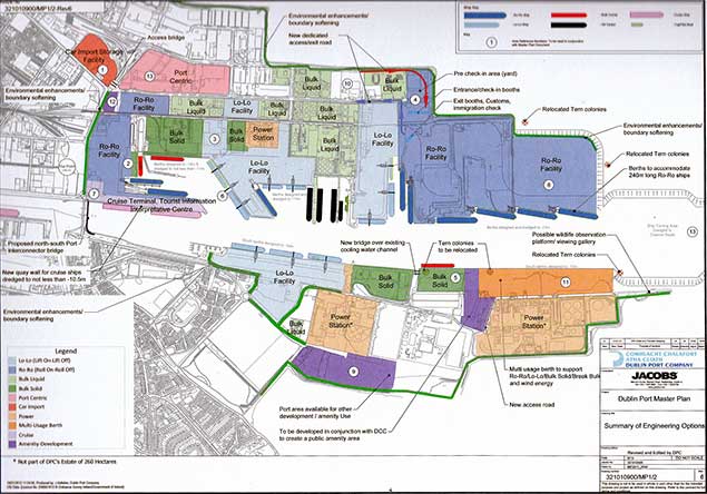 Connections between the north and south parts of the port are always under strain, and an early proposal was the installation of a second bridge immediately eastward of the present East Link Bridge
At the moment this parallel bridge seems to be proposed as a link exclusively for port traffic. But if that is the case then new road capacity has to be provided from the new bridge eastward to Poolbeg Roundabout, so an alternative scenario is that the new bridge be paired with the existing East Link to provide a dual carriageway, which in turn will be continued to the Poolbeg Roundabout.
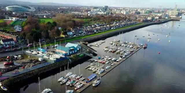
Providing such a dual carriageway will inevitably take a chunk out of the space at present used by Poolbeg Yacht & Boat Club both on the land and in their marina too. So instead of a compact marina clustered at the club, one variation of the plan shows an elongated marina running virtually the whole way to the new bridge immediately seaward of the northern lane of a the new dual carriageway.
However, while this may lessen the East Link bottleneck, most of the traffic using the East Link is not port-related anyway. They’re just people deluded by the notion that they’re taking the quickest way from the North City – and particularly the airport – to the vast affluent swathes of the south county. They arrive smoothly at the East Link via the Port Tunnel, and now if the East Link to Poolbeg Roundabout section become effectively a mini-motorway, they’ll be further deluded until they find themselves back in old-fashioned traffic jams as they try to make their way towards Sandymount Strand.
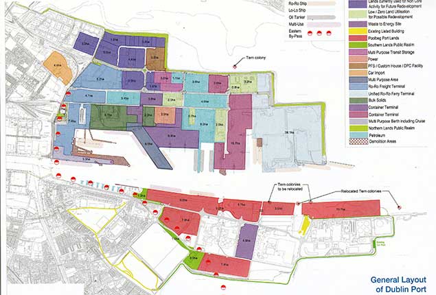 Hints of how the port might be. A new fixed bridge has been built across the mouth of the Dodder on the South Bank immediately upriver of the Eastlink, thereby cutting off access to the Grand Canal Basin for all but “canal boats”, while the line of red-and-white dots is the suggested route of the Eastern By-pass, which seems to be sent off from the Poolbeg Peninsula into the wide open spaces of Sandymount Strand.
So the old monster which just won’t go away, the Eastern Bypass, raises its head again in the proposals relating to the more distant future, though “distant” is only relative – 28 years is no time at all. Be that as it may, the cheapest option for an Eastern By-pass is a motorway-standard dual carriageway along Sandymount Strand, upon the completion of which, the next discussion will be where it re-joins the city’s road system.
But that’s an argument for another day which may not be necessary if another line of thought is taken, to which we’ll come in a minute. But right now, whatever happens, there’s no doubting that the cosy setup at Poolbeg, with a friendly club with a strong sense of community, and it all handy to the city, is under threat.
In fact, sometimes when you see ships manoeuvring within feet of the delicate marina structure in a real breeze of wind, you can’t help but think that you are watching a YouTube “Best Ship Disasters” vid in the making, and that Poolbeg Marina’s continued existence is a little miracle.
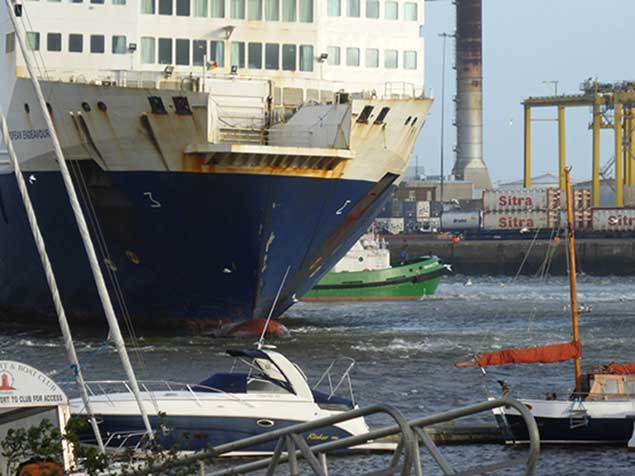 It can be quite thought-provoking to see ships being manoeuvred in a breeze of wind within a stone’s throw of Poolbeg Marina. Photo: W M Nixon
So the Poolbeg contingent are planning to be there in strength on Thursday to see for themselves just what the future might hold, and among other things they’ll see confirmation that a bus-lane-and-pedestrian bridge is highly likely across the mouth of the Dodder, thereby cutting off access to the Grand Canal Basin for vessels with masts or even just exceptional top hamper – the only reassurance I could get was that “canal boats” will have sufficient clearance.
As for the Eastern Bypass, if the cheapo version along the beach is built, then Sandymount will indeed have lost its strand. At the moment, the little coastal road is something you can walk across at any point, and the seashore seems very accessible. But as soon as you get eastward of Merrion Gates, the railway is defining most of the shoreline, and the sense of the sea being accessible is no longer so apparent – who ever talks of Booterstown Beach?
A motorway along the beach is every bit as much of a barrier as a railway, so it would be the end of Sandymount Strand as thousands know and love it. But anyway, if such a road were built, it would only deliver people further along the line into another jam. To make sense, it would have to go all the way to the nearest part of the M50/M11 linkup, which is somewhere about Leopardstown. Yet there’s just no way a raw new motorway is going to be built across this unrivalled area of prime real estate. However, north of the river the Port Tunnel is merrily working away, doing its work so well we almost forget it exists. Yet it seemed impossibly grandiose at the time it was first proposed.
A Ringsend to Leopardstown Tunnel would be about three times as long, and it would need at least two interchanges built into it to make logistical sense. But it is certainly well within the scope of fairly basic tunneling technology. And up in Arranmore in Donegal, there’s inherited tunneling expertise from the time of building the Channel Tunnel between England and France. The Arranmore economy would find the Ringsend-Leopardstown Tunnel a very nice little earner, thank you. And with some clever planning, it could leave the communities of Ringsend, Irishtown and Sandymount largely intact.


. He learned his sailing in the Royal Cork at Crosshaven but left Ireland (as did many others) in 1985 and is now so into America’s West Coast sailing scene that he owns a classic Cal 40")


 Michael Murphy Schull Harbour Sailing Club (SHSC), Eric Coogan Heineken Ireland, Mark Murphy, Commodore SHSC, Jack Allen SHSC, Carmel O'Regan SHSC, Cornelious Ndlovu, Schull Harbour Hotel Operations Manager and Derval Murphy SHSC")

