Menu

Ireland's sailing, boating & maritime magazine

Inland afloat headers


Displaying items by tag: Titanic

A month after the Titan submersible implosion, a memorial ceremony for Paul-Henri Nargeolet, one of five people who died, is due to be streamed live on Wednesday, July 19th.

The French deep-sea explorer and Titanic expert lost his life along with businessman Hamish Harding, OceanGate owner Stockton Rush, and father and son Suleman and Shahzada Dawood during an expedition to visit the Titanic off the coast of Newfoundland on June 18th.

The ceremony is being hosted by RMS Titanic Inc, which was awarded salvage-in-possession status for the wreck of the Titanic in 1994.

“We, with the rest of the world, watched the devastating news unfold that our friend and colleague Paul-Henri Nargeolet (whom we fondly refer to as “PH”) had perished along with four other passengers in the Titan accident,” RMS Titanic Inc said in a statement.

“ Five men, husbands, fathers, sons- one just 19 years old perished together, and we, again, extend our condolences to the families and friends of those lost. We are all deeply mourning,” it said.

“After careful thought and consideration, RMS Titanic, Inc. has decided to host a private memorial ceremony for our PH Nargeolet on July 19, 2023, 2:30 pm - 3:30 pm EDT (20h30 - 21h30 CEST), which will be streamed live to provide an outlet for the world-wide Titanic and oceanographic communities to remember our colleague and friend, and express our grief together,” it said.

“The in-person event will be closed to the public, but there is no registration necessary to watch and participate online,” it said.

The online link for participation is here

RMS Titanic Inc said it was also inviting people to share comments and memories of “PH” so they may be presented in a book to the family.

These can be recorded on this link 

Published in Titanic
Tagged under

The “maverick design” of the Titan submersible made it more susceptible to implosion, the New York Times has said.

The material used for the submersible may also have been a factor, the newspaper says.

Five people – businessman Hamish Harding, OceanGate owner Stockton Rush, Suleman Dawood with his father, Shahzada Dawood, and Paul-Henri Nargeolet – died last month during a dive in the submersible to the wreck of the Titanic.

A New York Times report quotes Tim Foecke, a retired forensic metallurgist, as stating that the change in hull geometry from a tight sphere to a lengthy tube may have contributed to Titan’s catastrophic failure.

“A spherical hull distributes the stress evenly, making it the best shape for resisting the compressive forces of the abyss,” the newspaper says.

Any other shape will “tend to deform unevenly”.

A larger hull needs to be stronger and thicker to withstand the same pressure as a smaller one, Foecke explained.

Experts who spoke to the newspaper compared Titan to Alvin, a research submersible with an all-titanium hull which has completed more than 4,500 dives since 1973.

It notes that OceanGate created most of Titan’s hull out of carbon fibre, rather than the conventional titanium used for Alvin. Experts said the risky design saved money.

Titan’s hull was larger and held two more passengers than Alvin, which fits three. In three years of dives, OceanGate charged up to 250,000 US dollars per person to visit the Titanic.

Read more in the New York Times here (subscription required).

Published in Titanic
Tagged under

A number of calls have been made for the Titanic shipwreck and grave site to be left alone following the recent loss of five lives in the Titan submersible implosion.

Pakistani businessman and son Shahzada and Suleman Dawood; British businessman Hamish Harding; French diver Paul-Henri Nargeolet; and Stockton Rush, the CEO of the vessel’s operator, OceanGate Expeditions, all died in the incident some 400 miles east of Newfoundland, Canada.

As reported by the Belfast Newsletter, a number of Titanic enthusiasts in both Northern Ireland and abroad have said the loss of life should lead to a review of how the wreck of the Titanic is treated.

Stephen Cameron, author of the book Titanic: Belfast’s Own, told the News Letter: “It's extremely sad, and my thoughts would be with the families of those who were lost”.

"But I've always said this from the word go, from when it was discovered: leave the thing alone. It's a grave site,” Cameron said.

"On what's left of the ship's bridge are plaques from everybody who has been down to it. It's disgraceful, to be perfectly honest with you,” he told the newspaper.

In a statement published online, Charles Haas, president of the Titanic International Society, said it was “time to consider seriously whether human trips to Titanic’s wreck should end in the name of safety, with relatively little remaining to be learned from or about the wreck”.

“Crewed submersibles’ roles in surveying the wreck now can be assigned to autonomous underwater vehicles,” he said.

“The world joins us in expressing our profound sadness and heartbreak about this tragic, avoidable event,” Haas said.

The late OceanGate CEO Stockton Rush had visited Belfast, and his company posted a photo online showing him in the old dry dock in the Titanic Quarter.

Former president of the Belfast Titanic Society Una Reilly, said she hopes that “sense will rear its head again” and that the grave site should be “left in peace”.

Read the Newsletter here

Published in Titanic
Tagged under

Rescuers are racing against the clock to locate and retrieve a tourist submarine that’s gone missing while on a dive to view the Titanic wreck site.

According to The Irish Times, prominent maritime experts and explorers are among the five people on board the mini submarine which lost contact with the surface less than two hours after going below on Sunday afternoon (18 June).

The missing vessel is OceanGate’s Titan, which since 2021 has been running expeditions for paying guests to the wreck of the ill-fated, Belfast-built ocean liner some 4km below the North Atlantic, as previously reported on Afloat.ie.

Search teams from the US and Canada are combing the area some 600km off Newfoundland in a “complex” operation as it is unknown whether the mini sub has surfaced or remains on the ocean floor.

And time is of the essence as officials believe the sub’s crew may run out of air between Wednesday (21) and Thursday (22 June).

The Irish Times has more on the story HERE.

Published in Titanic

The first full-size digital scan of the Titanic shipwreck lying 3,800 metres down in the Atlantic has been created using deep sea mapping.

As BBC News reports, the scan was carried out in the summer of 2022 by Magellan Ltd, a deep-sea mapping company, and Atlantic Productions, which is making a documentary about the project.

The team used submersibles, remotely controlled by a team on board a specialist ship, which took more than 700,000 images from every possible angle.

Over 200 hours were recorded surveying the length and breadth of the wreck, with the aim of shedding new light on what caused the ship to sink with the loss of 1,500 lives in 1912.

The shipwreck was discovered by North American oceanographer and marine geologist Robert Ballard in 1985, around 650km off the Canadian coast.

Ballard had been working with France’s Institut Français de Recherche pour l’Exploitation de la Mer and was on board the US Navy research ship Knorr.

Magellan's Gerhard Seiffert told BBC News it was the largest underwater scanning project he had undertaken.

"The depth of it, almost 4,000m, represents a challenge, and you have currents at the site, too - and we're not allowed to touch anything so as not to damage the wreck," he explained.

Irish diver Rory Golden, who is preparing for his fifth expedition to the ship, described the level of detail in the 3D images as "extraordinary".

In an interview with RTÉ Radio’s News At One, Golden said that “the bow section is the most recognisable feature”.

“The stern section is a mess. It's a very dangerous area; the images show that it's just a tangled mess of metal and steel,” he said.

"The bow plunged into the seabed, and the bow is something that people recognise, and it's still quite intact," he said.

"The stern area is the area which more or less exploded when it hit the bottom, and all the debris and artefacts are scattered around that area,” Golden said.

"To see the whole imaging like that done in such a vast expanse on the seabed is a unique experience for anyone to see," he said.

The BBC News report is here

Listen to Rory Golden’s interview on RTÉ Radio News at One here

Published in Titanic
Tagged under

A remarkable video including rare and previously unreleased footage reveals some of the first ever views of the wreck of the Titanic.

As the Belfast Telegraph reports, the feature-length posting on the Woods Hole Oceanographic Institution’s YouTube channel comprises uncut footage from a 1986 expedition to the site led by Robert Ballard, just months after the RMS Titanic’s final resting place was found.

The oceanographic team famously explored the site with a three-person submarine named Alvin, and captured images of its interior with and ROV called Jason Jr.

In a statement accompanying the film, Hollywood director and noted deep-sea exploration enthusiast James Cameron said: “By releasing this footage, WHOI is helping tell an important part of a story that spans generations and circles the globe.”

The Belfast Telegraph has more on the story HERE.

Published in Titanic
Tagged under

Harold Cottam was a 21-year old radio operator who was on duty on the night of April 14th, 1912 on board passenger ship RMS Carpathia when he received a Morse code message he would never forget.

Nor would the world, for Cottam was the telegraphist who picked up the first distress call from the RMS Titanic.

The RMS Carpathia was about four hours away from the Titanic, and steaming in the opposite direction towards the Mediterranean.

Its captain Arthur Rostron, changed course – which meant heading for ice - and took a number of measures to increase speed while ordering the crew to prepare food, blankets and medical care for any survivors.

The lesser-known story of the Carpathia’s role in rescuing 705 Titanic survivors has been recalled by Belfast author and illustrator Flora Delargy, whose grandfather and great grandfather both worked in the Belfast Shipyards where the Titanic was built.

Rescuing Titantic book

Morse code, navigation tools, the different roles of the crew, how the ships found each other, and by-the-minute details of exactly what happened on this cold and fateful night are reflected in her illustrated text, which has received critical claim from British publication The Bookseller.

Incidentally, the Carpathia, a Cunard Line passenger steamship, was sunk six years later on July 17th 1918 off the south Irish coast after being torpedoed three times by German submarine U-55.

Flora Delargy spoke to Wavelengths about her debut publication, and you can listen below

Published in Wavelength Podcast
Tagged under

A new illustrated story of quiet bravery tells in detail how the little ship Carpathia saved 705 passengers of the Titanic from the icy waters of the North Atlantic.

The intrepid little ship heroically changed course and headed straight into the frozen sea to help save as many people as it could.

Along the journey, you will learn all about Morse code, navigation tools, the different roles of the crew, how the ships found each other, and by-the-minute details of exactly what happened on this cold and fateful night.

Flora Delargy is an author and illustrator from Belfast who loves to bring to life true tales and events from the past. Her grandfather and great grandfather both worked in the Belfast Shipyards where the Titanic was built.

Published in Titanic
Tagged under

Deep down, four miles beneath the surface of the North Atlantic, the wreck of Titanic is dying as Nature "takes it back to itself."

So says Irish diver Rory Golden who is taking part in the current expedition to the wreck site using the newest submersible in the world, Titan. But, he says, the part of the tragic liner most remembered by the public will survive – the bow.

Titan on the surface at the wreck siteSubmerisible Titan on the surface at the wreck site

That has evocative memories for me as I outline on this week's Podcast with Rory Golden.

The expedition has been eleven years in preparation by the privately-owned USA company, OceanGate, which was founded in 2009 with the aim of increasing access to the deep ocean. It required a lot of discussion with the Canadian authorities before the expedition was allowed proceed.

Seabed image from Titanic site  Photo: Rory GoldenSeabed image from Titanic site Photo: Rory Golden

Podcast here.

Published in Tom MacSweeney
Tagged under

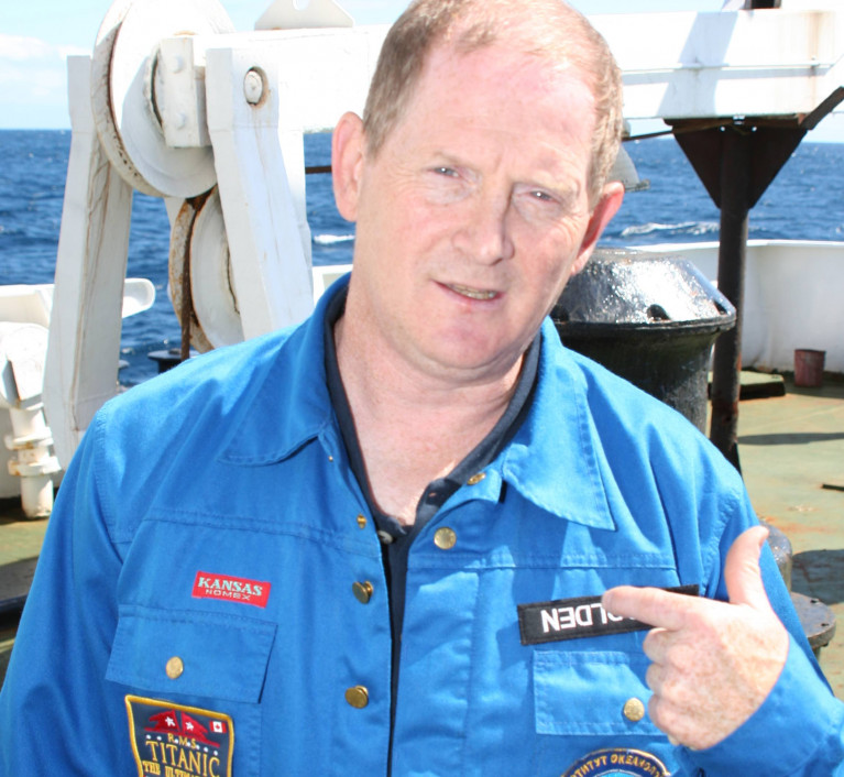
Dublin Bay diver Rory Golden will join the 2021 Titanic Survey Expedition starting in May going back to the wreck after a gap of 16 years, and taking part in a “sea bed” breaking scientific expedition.

Golden has over 44 years of dive experience and played key roles in Titanic expeditions and dives in 2000 and 2005.

Citizen explorers, known as Mission Specialists, will work hand-in-hand with Golden and other scientific, archaeological, and oceanographic experts throughout the expedition.

“I will never forget the first time I saw the Titanic. We were travelling along the flat ocean floor towards the ship and we came upon a wall of mud,” recalls Rory Golden. “We were at the forward section, near the bow, and we slowly rose up a steel wall that was covered in rivets and rusticles. Eventually we ascended over the top and there she was. It was a rush of emotion. She is massive and awe-inspiring. You are excited, amazed, and, at the same time, you feel a deep sadness for all those lost. It is unlike anything else I have experienced in over 40 years of diving. In the five short years between my dives to the Titanic the changes were dramatic. I’m anxious to bear witness to the deep ocean’s impact on this historic sight,” says Golden.

The bow of the Titantic Photo: Rory GoldenThe bow of the Titanic Photo: Rory Golden

Rory is highly regarded in the dive and Titanic communities. As a member of the Explorers Club and Vice Chair of the Great Britain and Ireland Chapter, he has been an active explorer, diver, and researcher dedicated to the preservation of Titanic history. We are proud and excited to welcome him to our expeditionary team for the 2021 Titanic Survey Expedition,” says Stockton Rush, President, OceanGate Expeditions. “His knowledge and previous documentation of this revered shipwreck will help us navigate the features of the wreck site and assess how quickly the wreck is decaying,” continues Rush.

Six missions scheduled for Summer 2021 will mark the inaugural expedition of a multi-year effort to preserve Titanic history for future generations and document the rate of decay of the important site. Using an array of high-resolution 4K cameras, a laser scanner, and sonar equipment, OceanGate Expeditions’ team will create a fully explorable photorealistic virtual 3-D model of the site.

Each participating citizen scientist will embark on 8-days at sea as a Mission Specialist crewmember and make one untethered 8 to 10-hour submersible dive as part of a 5-person team (sub pilot, subject matter expert, three mission specialists).

Each submersible dive team will spend several hours exploring the renowned Titanic wreck-site. The Summer 2021 Expedition schedule runs late-May through mid-July.

Published in Diving
Tagged under
Page 1 of 8

General Information on using Waterways Ireland inland navigations

Safety on the Water

All users of the navigations are strongly recommended to make themselves aware of safety on the water for whatever activity they are involved in and to read the advice offered by the various governing bodies and by:

The Dept. of Transport, Ireland: www.gov.ie/transport and The Maritime and Coastguard Agency, UK, The RNLI – Water Safety Ireland for information in terms of drowning prevention and water safety.

Registration of Vessels

All vessels using the Shannon Navigation, which includes the Shannon-Erne Waterways and the Erne System must be registered with Waterways Ireland. Only open undecked boats with an engine of 15 horsepower or less on the Shannon Navigation, and vessels of 10 horsepower or less on the Erne System, are exempt. Registration is free of charge.

Craft registration should be completed online at: https://www.waterwaysireland.org/online-services/craft-registration

Permits for use of the Grand and Royal Canals and the Barrow Navigation

All vessels using the Grand and Royal Canals and the Barrow Navigation must display appropriate valid Permit(s) i.e A Combined Mooring and Passage Permit (€126) and if not intending to move every five days, an Extended Mooring Permit (€152).

Permit applications should be completed online at: https://www.waterwaysireland.org/online-services/canal-permits

Passage on the Royal and Grand Canals – Dublin Area

For boat passage through the locks east of Lock 12 into / out of Dublin on either the Royal or Grand Canals, Masters are requested to contact the Waterways Ireland Eastern Regional Office (M-F 9.30am-4.30pm) on tel: +353(0)1 868 0148 or email [email protected] prior to making passage in order to plan the necessary lock-keeping assistance arrangements.

On the Grand Canal a minimum of two days notice prior to the planned passage should be given, masters should note that with the exception of pre-arranged events, a maximum of 2 boats per day will be taken through the locks, travelling either east or west.

Movements in or out of the city will be organised by prior arrangement to take place as a single movement in one day. Boaters will be facilitated to travel the system if their passage is considered to be safe by Waterways Ireland and they have the valid permit(s) for mooring and passage.

Newcomen Lifting Bridge

On the Royal Canal two weeks’ notice of bridge passage (Newcomen Lifting Bridge) is required for the pre-set lift date, and lock assistance will then also be arranged. A minimum of 2 boats is required for a bridge lift to go ahead.

Waterways Ireland Eastern Regional Office (Tel: +353(0)1 868 0148 or [email protected] ) is the point of contact for the bridge lift.

A maximum number of boats passing will be implemented to keep to the times given above for the planned lifts (16 for the Sat / Sun lifts & 8 for the weekday lifts). Priority will be given on a first come first served basis.

On day of lift, boaters and passengers must follow guidance from Waterways Ireland staff about sequence of passage under bridge & through Lock 1, and must remain within signed and designated areas.

Events Held on the Waterways

All organised events taking place on the waterways must have the prior approval of Waterways Ireland. This is a twelve week process and application forms must be accompanied with the appropriate insurance, signed indemnity and risk assessment. The application should be completed on the Waterways Ireland events page at :

https://www.waterwaysireland.org/online-services/event-approval

Time Limits on Mooring in Public Harbours

On the Shannon Navigation and the Shannon-Erne Waterway craft may berth in public harbours for five consecutive days or a total of seven days in any one month.

On the Erne System, revised Bye Laws state that: No master or owner shall permit a vessel, boat or any floating or sunken object to remain moored at or in the vicinity of any public mooring, including mooring at any other public mooring within 3 kilometres of that location, for more than 3 consecutive days and shall not moor at that same mooring or any other public mooring within 3 kilometres of that location within the following 3 consecutive days without prior permission by an authorised official.

Winter Mooring on the Shannon Navigation and Shannon Erne Waterway

Winter mooring may be availed of by owners during the period 1 Nov to 31 Mar by prior arrangement and payment of a charge of €63.50 per craft. Craft not availing of Winter Mooring must continue to comply with the “5 Day Rule”. Winter Mooring applications should be completed online at : https://www.waterwaysireland.org/online-services/winter-moorings-booking

Owners should be aware that electricity supply and water supply to public moorings is disconnected for the winter months. This is to protect against frost damage, to reduce running costs and to minimise maintenance requirements during the winter months.

Vessel owners are advised that advance purchasing of electricity on the power bollards leading up to the disconnection date should be minimal. Electricity credit existing on the bollards will not be recoverable after the winter decommissioning date. Both services will be reinstated prior to the commencement of the next boating season.

Smart Cards

Waterways Ireland smart cards are used to operate locks on the Shannon Erne Waterway, to access the service blocks, to use the pump-outs along the navigations, to avail of electrical power at Waterways Ireland jetties.

Berthing in Public Harbours

Masters are reminded of the following:

  • Equip their vessel with mooring lines of appropriate length and strength and only secure their craft to mooring bollards and cleats provided for this purpose.
  • Ensure the available berth is suitable to the length of your vessel, do not overhang the mooring especially on finger moorings on floating pontoon moorings.
  • Ensure mooring lines, electric cables and fresh water hoses do not create a trip hazard on public jetties for others users.
  • Carry sufficient fenders to prevent damage to your own vessel, other vessels and WI property.
  • Allow sufficient space between your vessel and the vessel ahead /astern (c.1m) for fire safety purposes and /or to recover somebody from the water.
  • Do not berth more than two vessels side by side and ensure there is safe access/egress at all times between vessels and onto the harbour itself.
  • Do not berth in such a way to prevent use of harbour safety ladders, slipways or pump-outs.
  • Do not allow the bow of your vessel to overhang the walkway of a floating mooring thus creating a hazard for others with an overhanging anchor or bow fendering.
  • Animals are not allowed to be loose or stray at any time.
  • Harbour and jetty infrastructure such as railings, power pedestals, fresh water taps, electric light poles, safety bollards, ladders etc are not designed for the purpose of mooring craft , they will not bear the strain of a vessel and will be damaged.
  • At Carrybridge on the Erne System, Masters of vessels are not permitted to use stern on mooring. Masters of vessels must use the mooring fingers for mooring of vessels and for embarkation / disembarkation from vessels.

Passenger Vessel Berths

Masters of vessels should not berth on passenger vessel berths where it is indicated that an arrival is imminent. Passenger vessels plying the navigations generally only occupy the berths to embark and disembark passengers and rarely remain on the berths for extended periods or overnight.

Lock Lead-in Jetties

Lead-in jetties adjacent to the upstream and downstream gates at lock chambers are solely for the purpose of craft waiting to use the lock and should not be used for long term berthing.

Vessel Wake

Vessel wake, that is, the wave generated by the passage of the boat through the water, can sometimes be large, powerful and destructive depending on the hull shape and engine power of the vessel. This wake can be detrimental to other users of the navigation when it strikes their craft or inundates the shoreline or riverbank. Masters are requested to frequently look behind and check the effect of their wake / wash particularly when passing moored vessels, on entering harbours and approaching jetties and to be aware of people pursuing other activities such as fishing on the riverbank.

Speed Restriction

A vessel or boat shall not be navigated on the Shannon Navigation at a speed in excess of 5 kph when within 200 metres of a bridge, quay, jetty or wharf, when in a harbour or canal or when passing within 100 metres of a moored vessel or boat.

Vessels navigating the Shannon-Erne Waterway should observe the general 5 kph speed limit which applies along the waterway. This is necessary in order to prevent damage to the banks caused by excessive wash from vessels.

Vessels navigating the Erne System should observe the statutory 5kt / 6mph / 10kph speed limit areas.

A craft on the Royal and Grand canals shall not be navigated at a speed in excess of 6km per hour.

A craft on the Barrow Navigation shall not be navigated at a speed in excess of 11km per hour except as necessary for safe navigation in conditions of fast flow.

Bank Erosion

Narrow sections of all the navigations are particularly prone to bank erosion due to the large wash generated by some craft. Masters are requested to be vigilant and to slow down to a speed sufficient to maintain steerage when they observe the wash of their craft inundating the river banks.

Unusual Waterborne Activity

Unusual waterborne vessels may be encountered from time to time, such as, hovercraft or amphibious aircraft / seaplanes. Masters of such craft are reminded to apply the normal “Rule of the Road” when they meet conventional craft on the water and to allow extra room to manoeuvre in the interest of safety.

Sailing Activity

Mariners will encounter large numbers of sailing dinghies from late June to August in the vicinity of Lough Derg, Lough Ree and Lower Lough Erne. Sailing courses are marked by yellow buoys to suit weather conditions on the day. Vessels should proceed at slow speed and with due caution and observe the rules of navigation when passing these fleets, as many of the participants are junior sailors under training.

Rowing

Mariners should expect to meet canoes and vessels under oars on any part of the navigations, but more so in the vicinity of Athlone, Carrick-on-Shannon, Coleraine, Enniskillen and Limerick. Masters are reminded to proceed at slow speed and especially to reduce their wash to a minimum when passing these craft as they can be easily upset and swamped due to their very low freeboard and always be prepared to give way in any given traffic situation.

Canoeing

Canoeing is an adventure sport and participants are strongly recommended to seek the advice of the sport’s governing bodies i.e Canoeing Ireland and the Canoe Association of Northern Ireland, before venturing onto the navigations.

Persons in charge of canoes are reminded of the inherent danger to these craft associated with operating close to weirs, sluice gates, locks and other infrastructure particularly when rivers are in flood and large volumes of water are moving through the navigations due to general flood conditions or very heavy localised precipitation e.g. turbulent and broken water, stopper waves. Shooting weirs is prohibited without prior permission of Waterways Ireland.

Canoeists should check with lockkeepers prior entering a lock to ensure passage is done in a safe manner. Portage is required at all unmanned locks.

Canoe Trail Network – "Blueways"

Masters of powered craft are reminded that a canoe trail network is being developed across all navigations and to expect more organised canoeing along these trails necessitating slow speed and minimum wash when encountering canoeists, rowing boats etc

Rockingham and Drummans Island Canals – Lough Key

It is expected that work on Rockingham and Drummans Island Canals on Lough Key will be completed in 2021. Access to these canals will be for non-powered craft only, eg canoes, kayaks, rowing boats.

Fast Powerboats and Personal Watercraft (Jet Skis)

Masters of Fast Powerboats (speed greater than 17kts) and Personal Watercraft (i.e.Jet Skis) are reminded of the inherent dangers associated with high speed on the water and especially in the confines of small bays and narrow sections of the navigations. Keeping a proper look-out, making early alterations to course and /or reducing speed will avoid conflict with slower vessels using the navigation. Personal Watercraft are not permitted to be used on the canals.

Towing Waterskiers, Wakeboarders, Doughnuts etc

Masters of vessels engaged in any of these activities are reminded of the manoeuvring constraints imposed upon their vessel by the tow and of the added responsibilities that they have to the person(s) being towed. These activities should be conducted in areas which are clear of conflicting traffic. It is highly recommended that a person additional to the master be carried to act as a “look-out” to keep the tow under observation at all times.

Prohibition on Swimming

Swimming in the navigable channel, particularly at bridges, is dangerous and is prohibited due to the risk of being run over by a vessel underway in the navigation.

Age Restrictions on operating of powered craft

In the Republic of Ireland, Statutory Instrument 921 of 2005 provides the legal requirements regarding the minimum age for operating of powered craft. The Statutory Instrument contains the following requirements:

- The master or owner of a personal watercraft or a fast power craft shall take all reasonable steps to ensure that a person who has not attained the age of 16 years does not operate or control the craft

- The master or owner of a pleasure craft powered by an engine with a rating of more than 5 horse power or 3.7 kilowatts shall take all reasonable steps to ensure that a person who has not attained the age of 12 years does not operate or control the craft.

Lifejackets and Personal Flotation Devices (PFDs)

Lifejackets and PFD’s are the single most important items of personal protective equipment to be used on a vessel and should be worn especially when the vessel is being manoeuvred such as entering / departing a lock, anchoring, coming alongside or departing a jetty or quayside.

In the Republic of Ireland, Statutory Instrument 921 of 2005 provides the legal requirements regarding the wearing of Personal Flotation Devices. The Statutory Instrument contains the following requirements:

- The master or owner of a pleasure craft (other than a personal watercraft) shall ensure, that there are, at all times on board the craft, sufficient suitable personal flotation devices for each person on board.

- A person on a pleasure craft (other than a personal watercraft) of less than 7 metres length overall shall wear a suitable personal flotation device while on board an open craft or while on the deck of decked craft, other than when the craft is made fast to the shore or at anchor.

- The master or owner of a pleasure craft (other than a personal watercraft) shall take all reasonable steps to ensure that a person who has not attained the age of 16 years complies with paragraph above.

- The master or owner of a pleasure craft (other than a personal watercraft), shall take all reasonable steps to ensure that a person who has not attained the age of 16 years wears a suitable personal flotation device while on board an open craft or while on the deck of a decked craft other than when it is made fast to the shore or at anchor.

- The master or owner of a pleasure craft (other than a personal watercraft) shall take all reasonable steps to ensure that a person wears a suitable personal flotation device, at all times while – (a) being towed by the craft, (b) on board a vessel or object of any kind which is being towed by the craft.

Further information is available at: http://www.irishstatutebook.ie/eli/2005/si/921/made/en/print

Firing Range Danger Area – Lough Ree

The attention of mariners is drawn to the Irish Defence Forces Firing Range situated in the vicinity of buoys No’s 2 and 3, on Lough Ree on the Shannon Navigation. This range is used regularly for live firing exercises, throughout the year, all boats and vessels should stay clear of the area marked with yellow buoys showing a yellow "X" topmark and displaying the word "Danger".

Shannon Navigation, Portumna Swing Bridge Tolls

No attempt should be made by Masters’ of vessels to pay the bridge toll while making way through the bridge opening. Payment will only be taken by the Collector from Masters when they are secured alongside the jetties north and south of the bridge.

Navigating from Killaloe to Limerick on the Shannon Navigation

The navigation from Killaloe to Limerick involves passage through Ardnacrusha locks, the associated headrace and tailrace and the Abbey River into Limerick City. Careful passage planning is required to undertake this voyage. Considerations include: lock passage at Ardnacrusha, water flow in the navigation, airdraft under bridges on Abbey River in Limerick, state of tide in Limerick

Users are advised to contact the ESB Ardnacrusha hydroelectric power station (00353 (0)87 9970131) 48 hours in advance of commencing their journey to book passage through the locks at Ardnacrusha. It is NOT advised to undertake a voyage if more than one turbine is operating (20MW), due to the increased velocity of flow in the navigation channel, which can be dangerous. To ascertain automatically in real time how many turbines are running, users can phone +353 (0)87 6477229.

For safety reasons the ESB has advised that only powered craft with a capacity in excess of 5 knots are allowed to enter Ardnacrusha Headrace and Tailrace Canals.

Passage through Sarsfield Lock should be booked on +353-87-7972998, on the day prior to travel and it should be noted also that transit is not possible two hours either side of low water.

A Hydrographic survey in 2020 of the navigation channel revealed that the approach from Shannon Bridge to Sarsfield Lock and the Dock area has silted up. Masters of vessels and water users are advised to navigate to the Lock from Shannon bridge on a rising tide one or two hours before High Tide.

Lower Bann Navigation

The attention of all users is drawn to the “Users Code for the Lower Bann”, in particular to that section covering “Flow in the River” outlining the dangers for users both on the banks and in the navigation, associated with high flow rates when the river is in spate. Canoeists should consult and carry a copy of the “Lower Bann Canoe Trail” guide issued by the Canoe Association of Northern Ireland. Users should also contact the DfI Rivers Coleraine, who is responsible for regulating the flow rates on the river, for advisory information on the flow rates to be expected on any given day.

DfI Rivers Coleraine. Tel: 0044 28 7034 2357 Email: [email protected]

Lower Bann Navigation – Newferry – No wake zone

A No Wake Zone exists on the Lower Bann Navigation at Newferry. Masters of vessels are requested to proceed at a slow speed and create no wake while passing the jetties and slipways at Newferry.

Overhead Power Lines (OHPL) and Air draft

All Masters must be aware of the dangers associated with overhead power lines, in particular sailing vessels and workboats with cranes or large air drafts. Voyage planning is a necessity in order to identify the location of overhead lines crossing the navigation.

Overhead power line heights on the River Shannon are maintained at 12.6metres (40 feet) from Normal Summer level for that section of navigation, masters of vessels with a large air draft should proceed with caution and make additional allowances when water levels are high.

If a vessel or its equipment comes into contact with an OHPL the operator should NOT attempt to move the vessel or equipment. The conductor may still be alive or re-energise automatically. Maintain a safe distance and prevent third parties from approaching due to risk of arcing. Contact the emergency services for assistance.

Anglers are also reminded that a minimum ground distance of 30 metres should be maintained from overhead power lines when using a rod and line.

Submarine Cables and Pipes

Masters of vessels are reminded not to anchor their vessels in the vicinity of submarine cables or pipes in case they foul their anchor or damage the cables or pipes. Look to the river banks for signage indicating their presence.

Water Levels - Precautions

Low Water Levels:

When water levels fall below normal summer levels masters should be aware of:

Navigation

To reduce the risk of grounding masters should navigate on or near the centreline of the channel, avoid short cutting in dog-legged channels and navigating too close to navigation markers.

Proceeding at a slow speed will also reduce “squat” effect i.e. where the vessel tends to sit lower in the water as a consequence of higher speed.

Slipways

Reduced slipway length available under the water surface and the possibility of launching trailers dropping off the end of the concrete apron.

More slipway surface susceptible to weed growth requiring care while engaged in launching boats, from slipping and sliding on the slope. Note also that launching vehicles may not be able to get sufficient traction on the slipway once the craft is launched to get up the incline.

Bank Erosion

Very dry riverbanks are more susceptible to erosion from vessel wash.

Lock Share

Maximising on the number of vessels in a lock will ensure that the total volume of water moving downstream is decreased. Lock cycles should be used for vessels travelling each way.

High Water Levels:

When water levels rise above normal summer level masters should be aware of:

Navigation

Navigation marks will have reduced height above the water level or may disappear underwater altogether making the navigable channel difficult to discern.

In narrow sections of the navigations water levels will tend to rise more quickly than in main streams and air draft at bridges will likewise be reduced.

There will also be increased flow rates particularly in the vicinity of navigation infrastructure such as bridges, weirs, locks etc where extra care in manoeuvring vessels will be required.

Harbours and Jetties

Due care is required in harbours and at slipways when levels are at or near the same level as the harbour walkways' as the edge will be difficult to discern especially in reduced light conditions. It is advised that Personal Flotation Devices be worn if tending to craft in a harbour in these conditions.

Slipways

Slipways should only be used for the purpose of launching and recovering of water craft or other objects from the water. Before using a slipway it should be examined to ensure that the surface has sufficient traction/grip for the intended purpose such as launching a craft from a trailer using a vehicle, that there is sufficient depth of water on the slipway to float the craft off the trailer before the concrete apron ends and that the wheels of the trailer do not drop off the edge of the slipway. That life-saving appliances are available in the vicinity, that the vehicle is roadworthy and capable of coping with the weight of the trailer and boat on the incline. It is recommended that slipway operations are conducted by two persons.

Caution to be Used in Reliance upon Aids to Navigation

The aids to navigation depicted on the navigation guides comprise a system of fixed and floating aids to navigation. Prudent mariners will not rely solely on any single aid to navigation, particularly a floating aid to navigation. With respect to buoys, the buoy symbol is used to indicate the approximate position of the buoy body and the ground tackle which secures it to the lake or river bed. The approximate position is used because of the practical limitations in positioning and maintaining buoys in precise geographical locations. These limitations include, but are not limited to, prevailing atmospheric and lake/river conditions, the slope of and the material making up the lake/river bed, the fact that the buoys are moored to varying lengths of chain, and the fact that the buoy body and/or ground tackle positions are not under continuous surveillance. Due to the forces of nature, the position of the buoy body can be expected to shift inside and outside the charted symbol.

Buoys and perches are also moved out of position or pulled over by those mariners who use them to moor up to instead of anchoring. To this end, mariners should always monitor their passage by relating buoy/perch positions with the published navigation guide. Furthermore, a vessel attempting to pass close by always risks collision with a yawing buoy or with the obstruction that the buoy or beacon/perch marks.

Masters of Vessels are requested to use the most up to date Navigation guides when navigating on the Inland Waterways.

Information taken from Special Marine Notice No 1 of 2023