Menu

Ireland's sailing, boating & maritime magazine

Inland afloat headers


Displaying items by tag: Corrib

A multi-agency group warns that lives of rescuers on Galway’s river Corrib are being put at risk by salmon and eel traps on a city stretch below the Salmon Weir.

As The Sunday Independent report, Galway’s chief fire officer Gerry O’Malley has said the structures owned by Inland Fisheries Ireland (IFI) pose “significant risk” to his staff.

The structures associated with a salmon pass known as “The Queen’s Gap” and eel traps are out of bounds now to Galway Fire and Rescue Service crew.

A person caught in the fast flow in that area could die from impact, or could drown if caught in or pinned to one of the rails stretching across the river, O’Malley warns.

A body of a missing person, which was found in the river, had been trapped in the rails of one of the structures for almost three weeks, according to Galway City councillor and chair of the Claddagh Watch river patrol group Niall McNelis (Lab).

McNelis, who participates in the Inter-Agency Corrib Water Safety Group on behalf of Claddagh Watch, has tabled a motion on the issue for a city council meeting tomorrow (Mon, July 10).

“This is an issue of general safety for anyone on or near the river, but also the safety of rescuers,” RNLI lifeboat operations manager Mike Swan, also on the inter-agency group, says.

That safety risk came into very sharp focus in January of this year, when up to ten people were rescued after three rowing boats attached to the University of Galway and to Coláiste Iognaid secondary school capsized when the river was in flood.

“Several of the boats were caught at the top of the Salmon Weir. If any of those crew had been swept over the weir, they would not have survived the Queen’s Gap,” Swan confirmed.

Galway Fire and Rescue crews responded to 29 water rescue incidents in 2020, 57 in 2021 and 29 last year, most of which were on the river Corrib. The crews have responded to 18 separate water incidents, also mainly on the Corrib, this year to date.

IFI says the structures are “listed”, and it is “in ongoing discussions with Galway City Council to best understand how to manage these structures into the future”.

Read more in The Sunday Independent here

Published in Galway Harbour
Tagged under

The “Longest Day Swim” on Galway’s river Corrib takes place this Saturday after a two–year break due to Covid-19.

North American Olympic gold medallist Joseph “Gunnar” Bentz has been invited to lead the event on July 2nd.

Bentz won two gold and two bronze medals at the FINA World Junior swimming championships, and holds silver and bronze medals from the Pan American Games.

Two courses – four km and 2.5km – have been set from Glenlo Abbey and Dangan, with both finishing at Steamer’s quay, Woodquay, in Galway city.

Galway Swimming Club (GSC) is hosting the event, with funds going to the young people’s mental health charity, Jigsaw.

The timed river swim is open to competent open water swimmers who must be over 18, and must be members of Swim Ireland for insurance purposes.

. “We’re delighted to bring back the Longest Day Swim and to promote the physical and mental health benefits of swimming,” GSC chairman Mark Gibbs has said.

“I’m particularly happy to welcome Jigsaw on board as our charity of choice this year.”

Places are said to be “filling up fast” and more details are here

Published in Sea Swim

Community partnership Corrib Beo has initiated a series of educational field trips as part of its mission to promote the sustainable development of the Lough Corrib catchment in the west.

Transition year (TY) students from Coláiste Iognáid participated in the first such field trip with architect, environmentalist and broadcaster Duncan Stewart.

The TY course, named Eco Advocates, is an initiative of EcoEd4All, the environmental pillar of Corrib Beo.

Corrib Beo is a coalition of communities, environmentalists and voluntary groups dedicated to the care protection and sustainable development of the Corrib, its catchment landscapes, rivers and canals.

During the first field trip, the Coláiste Iognáid students joined Stewart and Eco Advocate course leader Jen Cunningham on the banks of the waterway, where Stewart discussed the importance of engaging with the key environmental themes of biodiversity, climate change, circular economy and water/air Pollution.

A water quality sampling session was led by Galway-Mayo Institute of Technology marine biology students, Molly Curran and Joseph Donnelly.

Galway National City Park founder Brendan ‘Speedie’ Smith, who is a committee member and content contributor to EcoEd4All, also spoke to students about the importance of the circular economy and the Galway National Park City initiative.

All school enquiries for TY bookings on the EcoAdvocate scheme should email [email protected] or phone 087 7660818.

Published in Marine Science
Tagged under

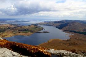
Oscar Wilde’s surgeon dad waxed lyrical about it, Vikings lost their weapons in it, and poitín makers and anglers have shared their knowledge of its rocks and islands.

The Corrib – this island’s second largest lake after Lough Neagh – is also host for the Cong-Galway yacht race, which is said to be Europe’s oldest contest of its type.

Game anglers are well familiar with the Corrib, but the catchment could also be Ireland’s Cumbria, a new group says.

The Corrib Beo catchment partnership, which is holding its first conference later this week in Galway (May 2), describes itself as a “coalition of activists and interest groups” which aims to realise a new “shared vision” for the freshwater environment.

It aims to develop a 25-year plan for the entire system extending from Cong and Lisloughrey to Galway city.

“The Wild Atlantic Way is attracting record numbers, but those same visitors attracted to the coastline should know that the Corrib is the pendant on that necklace,” Corrib Beo co-founder Denis Goggin, says.

The Corrib is a special area of conservation, and surgeon Sir William Wilde was author of its best-known history, Lough Corrib: Its Shores and Islands, published in 1867.

A 4,500-year-old log boat was among 12 early Bronze Age, Iron Age and medieval craft and several Viking-style battle axes discovered over five years ago by marine surveyor Capt Trevor Northage during his work to update the charts of the lake.

The 44 km-long waterway is managed by a number of State agencies and the two local authorities in Galway and Mayo. The lake rich in wildlife faces constant pressures from pollution and invasive species, such as the curly waterweed, Lagarosiphon Major, which Inland Fisheries Ireland has been tackling.

The Corrib Navigation Trustees, who report to Galway City Council, are responsible for maintenance of navigation aids, piers, the Eglinton canal system and associated walkways and lock gates.

Irish walkers are well familiar with the quartzite Maaumturks and the Maaumtrasna and Partry mountains which provide the backdrop to its limestone pavements, along with the bog-carpeted granite of south Connemara.

However, its potential does not have the international caches of Cumbria and the Lake District which attracted over 47 million visitors in 2017, according to Mr Goggin.

The region, embracing England’s highest mountains and the Lake District national park, employed over 38,000 people and generated £2.9 billion sterling to the region's economy according to 2017 figures issued by Cumbria Tourism.

“We are not saying we want the Corrib system overrun by international visitors in the way the Lake District can be, but there is scope for further sustainable development,” Mr Goggin said.

“The lake has several peripheral areas suffering from depopulation which could do with a boost,” he explains.

“Recently, a few of us travelled north to learn more about the Belfast Agenda, the community plan for Belfast which takes a partnership approach,” Mr Goggin says.

“All of the agencies and community groups are working there towards a common theme to transform one of the British empire’s largest industrial bases into a tourist venue, and we need to take a collective approach towards the Corrib here,” he says.

“The Corrib system is like an orchestra, with three different strands of economy, community and environment being like its wind, percussion and string instruments,” Mr Goggin says.

“The challenges presented in planning for the care, protection and sustainable development of the Corrib are a microcosm of the greater humanitarian and environmental challenges of our age,” the Corrib Beo group says.

“ However, the timing of this new initiative to address these challenges has never been more favourable in terms of the supports available at European, national and local level,” it says, and there is “much community goodwill”.

Corrib Beo is hosting its first conference on May 2nd in Galway’s Commercial Boat Club on Steamers’ Quay, and such is the interest that places are almost booked out already.

Former Environmental Protection Agency director Dr Micheál Ó Cinnéide will chair the day-long event, and speakers will include environmentalists Duncan Stewart and Brendan Smith.

Representatives from many different groups who are “already involved and interested in the protection and development of the Corrib waterways”, will also participate.

Published in Inland Waterways
Tagged under

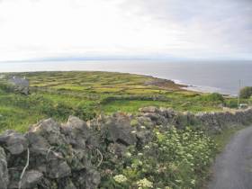
#MarineNotice - Repair works are currently ongoing on the Inis Mór–Inis Meáin cable weeks after a fault left the Aran Islands without power for a number of days.

The works, which began last Saturday 10 September and will continue for another week, weather permitting, are being carried out from an offshore platform manoeuvred with the assistance of workboats, as detailed in Marine Notice No 39 of 2016.

The tug ABBE is also operational in the vicinity of the platform during the repairs. Both platform and tug vessel maintain a listening watch on VHF Channels 12 and 16 for the duration of the project.

The platform is displaying day shapes and night lights as required in accordance with the International Regulations for Prevention of Collisions at Sea (COLREGS).

All vessels, particularly those engaged in fishing, are requested to give the area a wide berth and keep a sharp lookout in the relevant areas.

Another recent Marine Notice advises of a programme of maintenance and inspection on the Corrib subsea facilities from this week for the next three week.

Marine Notice No 38 of 2016 says the work will all take place within the 500m Safety Zone and will involve carrying out a programme of maintenance to investigate and repair some of
the subsea facilities as required.

The support vessel Olympic Ares will carry out the maintenance and inspection using a remote operated vehicle or ROV. The vessel will be listening on VHF Channel 16 throughout the project.

Published in Marine Warning

#MarineNotice - Marine Notice No 21 of 2015 from the Department of Transport, Tourism and Sport (DTTAS) advises that Shell E&P Ireland Ltd will be deploying a waverider buoy in late May 2015, weather permitting, in order to help predict sea conditions for the Corrib P2 well intervention work by the Ocean Guardian (Callsign V7FF7).

The buoy size is 90cm in diameter, and is set to be deployed at co-ordinates 54°19.285’N, 011°05.544’W (WGS84) approximate, with a 100m watch circle. The water depth at this location is 336 metres.

The waverider buoy will remain on site for approximately three months. Pictured here, it is yellow in colour and will flash yellow five times every 20 seconds.

All vessels are requested to give the waverider buoy a wide berth.

Published in Marine Warning

#illegalfishing – At a sitting of Galway District Court on Tuesday, 3rd February, Judge Denis McLaughlin convicted two men of illegal fishing, and issued fines and costs totalling €1,850. Michael Gannon of Raleigh Row, Galway City, and Brendan Hardiman, with an address at Mace, Corrandulla, Co. Galway were both in court on charges of the illegal use of a net, and illegal possession of a net in contravention of the 1959 Fisheries Act.

Judge McLaughlin heard evidence that on the night of 6th July 2014, fisheries officers on patrol observed the men in a boat on Lough Corrib setting a net. The men returned to shore and left the scene. At approximately 2 am on the 7th July the men returned to the lake, rowed out and retrieved the net. On return to shore they were challenged by the fisheries officers, and under caution they admitted the offences.

Both men were convicted by Judge McLaughlin on one count, with the second charge taken into account. It was acknowledged that on the night both defendants had been co-operative, had accepted responsibility for their actions and were pleading guilty to the charges. The judge heard that Mr. Hardiman had two previous convictions for similar offences, and he fined Mr. Hardiman €750, with €300 costs. Mr. Gannon was fined €500 with €300 costs.

Inland Fisheries Ireland (IFI) has a confidential hotline number to enable members of the general public to report incidents - 1890 34 74 24 or 1890 FISH 24. This phone line is designed to encourage the reporting of incidents of illegal fishing, water pollution and invasive species.

Published in Fishing
Tagged under
New Minister for the Environment Phil Hogan has signed off on a key foreshore licence to Shell Ireland, paving the way for the completion of the controversial Corrib gas project.
The Irish Times reports that the licence, subject to conditions, consents for the construction of the final 8km section of pipeline linking the Corrib gas field to Shell's onshore terminal at Ballinaboy. Co Mayo.
The scheme already has approval from An Bord Pleanála, and consents approved by former acting energy minister Pat Carey. But An Taisce has sought a judicial review of the planning decision, due before the High Court on Tuesday.
Still required by the developer before any work can begin are a revised emissions licence from the Environmental Protection Agency and a safety permit from the Commission for Energy Regulation under the Petroleum (Exploration and Extraction) Safety Act 2010.
The Irish Times has more on the story HERE.

New Minister for the Environment Phil Hogan has signed off on a key foreshore licence to Shell Ireland, paving the way for the completion of the controversial Corrib gas project.

The Irish Times reports that the licence, subject to conditions, consents for the construction of the final 8km section of pipeline linking the Corrib gas field to Shell's onshore terminal at Ballinaboy. Co Mayo.

The scheme already has approval from An Bord Pleanála, and consents approved by former acting energy minister Pat Carey. But An Taisce has sought a judicial review of the planning decision, due before the High Court on Tuesday.

Still required by the developer before any work can begin are a revised emissions licence from the Environmental Protection Agency and a safety permit from the Commission for Energy Regulation under the Petroleum (Exploration and Extraction) Safety Act 2010.

The Irish Times has more on the story HERE.

Published in Coastal Notes

Any potential risk from the Corrib gas pipeline off Ireland's west coast has been "overstated", according to representatives from Shell.

On the final day of the An Bord Pleanála hearing into the final phase of the pipeline, the oil company's senior counsel moved to assure a concerned public that the project was designed to "the highest safety standards".

"No other Irish development proposal has been subject to such an amount of study and surveys over such a period of time,” said Esmonde Keane at the hearing in Belmullet, Co Mayo on 1 October.

The Corrib project involves the development of a gas field west of the Mullet Peninsula, including the construction of a pipeline to the mainland and a coastal processing plant. The mainland phase of the plan has attracted much concern among local residents.

Two opponents of the project, environmental consultant Peter Sweetman and Monica Muller, a local resident, walked out of the hearing in protest over Keane's closing remarks, arguing that they were intended as “a legal submission”.

Published in Coastal Notes

General Information on using Waterways Ireland inland navigations

Safety on the Water

All users of the navigations are strongly recommended to make themselves aware of safety on the water for whatever activity they are involved in and to read the advice offered by the various governing bodies and by:

The Dept. of Transport, Ireland: www.gov.ie/transport and The Maritime and Coastguard Agency, UK, The RNLI – Water Safety Ireland for information in terms of drowning prevention and water safety.

Registration of Vessels

All vessels using the Shannon Navigation, which includes the Shannon-Erne Waterways and the Erne System must be registered with Waterways Ireland. Only open undecked boats with an engine of 15 horsepower or less on the Shannon Navigation, and vessels of 10 horsepower or less on the Erne System, are exempt. Registration is free of charge.

Craft registration should be completed online at: https://www.waterwaysireland.org/online-services/craft-registration

Permits for use of the Grand and Royal Canals and the Barrow Navigation

All vessels using the Grand and Royal Canals and the Barrow Navigation must display appropriate valid Permit(s) i.e A Combined Mooring and Passage Permit (€126) and if not intending to move every five days, an Extended Mooring Permit (€152).

Permit applications should be completed online at: https://www.waterwaysireland.org/online-services/canal-permits

Passage on the Royal and Grand Canals – Dublin Area

For boat passage through the locks east of Lock 12 into / out of Dublin on either the Royal or Grand Canals, Masters are requested to contact the Waterways Ireland Eastern Regional Office (M-F 9.30am-4.30pm) on tel: +353(0)1 868 0148 or email [email protected] prior to making passage in order to plan the necessary lock-keeping assistance arrangements.

On the Grand Canal a minimum of two days notice prior to the planned passage should be given, masters should note that with the exception of pre-arranged events, a maximum of 2 boats per day will be taken through the locks, travelling either east or west.

Movements in or out of the city will be organised by prior arrangement to take place as a single movement in one day. Boaters will be facilitated to travel the system if their passage is considered to be safe by Waterways Ireland and they have the valid permit(s) for mooring and passage.

Newcomen Lifting Bridge

On the Royal Canal two weeks’ notice of bridge passage (Newcomen Lifting Bridge) is required for the pre-set lift date, and lock assistance will then also be arranged. A minimum of 2 boats is required for a bridge lift to go ahead.

Waterways Ireland Eastern Regional Office (Tel: +353(0)1 868 0148 or [email protected] ) is the point of contact for the bridge lift.

A maximum number of boats passing will be implemented to keep to the times given above for the planned lifts (16 for the Sat / Sun lifts & 8 for the weekday lifts). Priority will be given on a first come first served basis.

On day of lift, boaters and passengers must follow guidance from Waterways Ireland staff about sequence of passage under bridge & through Lock 1, and must remain within signed and designated areas.

Events Held on the Waterways

All organised events taking place on the waterways must have the prior approval of Waterways Ireland. This is a twelve week process and application forms must be accompanied with the appropriate insurance, signed indemnity and risk assessment. The application should be completed on the Waterways Ireland events page at :

https://www.waterwaysireland.org/online-services/event-approval

Time Limits on Mooring in Public Harbours

On the Shannon Navigation and the Shannon-Erne Waterway craft may berth in public harbours for five consecutive days or a total of seven days in any one month.

On the Erne System, revised Bye Laws state that: No master or owner shall permit a vessel, boat or any floating or sunken object to remain moored at or in the vicinity of any public mooring, including mooring at any other public mooring within 3 kilometres of that location, for more than 3 consecutive days and shall not moor at that same mooring or any other public mooring within 3 kilometres of that location within the following 3 consecutive days without prior permission by an authorised official.

Winter Mooring on the Shannon Navigation and Shannon Erne Waterway

Winter mooring may be availed of by owners during the period 1 Nov to 31 Mar by prior arrangement and payment of a charge of €63.50 per craft. Craft not availing of Winter Mooring must continue to comply with the “5 Day Rule”. Winter Mooring applications should be completed online at : https://www.waterwaysireland.org/online-services/winter-moorings-booking

Owners should be aware that electricity supply and water supply to public moorings is disconnected for the winter months. This is to protect against frost damage, to reduce running costs and to minimise maintenance requirements during the winter months.

Vessel owners are advised that advance purchasing of electricity on the power bollards leading up to the disconnection date should be minimal. Electricity credit existing on the bollards will not be recoverable after the winter decommissioning date. Both services will be reinstated prior to the commencement of the next boating season.

Smart Cards

Waterways Ireland smart cards are used to operate locks on the Shannon Erne Waterway, to access the service blocks, to use the pump-outs along the navigations, to avail of electrical power at Waterways Ireland jetties.

Berthing in Public Harbours

Masters are reminded of the following:

  • Equip their vessel with mooring lines of appropriate length and strength and only secure their craft to mooring bollards and cleats provided for this purpose.
  • Ensure the available berth is suitable to the length of your vessel, do not overhang the mooring especially on finger moorings on floating pontoon moorings.
  • Ensure mooring lines, electric cables and fresh water hoses do not create a trip hazard on public jetties for others users.
  • Carry sufficient fenders to prevent damage to your own vessel, other vessels and WI property.
  • Allow sufficient space between your vessel and the vessel ahead /astern (c.1m) for fire safety purposes and /or to recover somebody from the water.
  • Do not berth more than two vessels side by side and ensure there is safe access/egress at all times between vessels and onto the harbour itself.
  • Do not berth in such a way to prevent use of harbour safety ladders, slipways or pump-outs.
  • Do not allow the bow of your vessel to overhang the walkway of a floating mooring thus creating a hazard for others with an overhanging anchor or bow fendering.
  • Animals are not allowed to be loose or stray at any time.
  • Harbour and jetty infrastructure such as railings, power pedestals, fresh water taps, electric light poles, safety bollards, ladders etc are not designed for the purpose of mooring craft , they will not bear the strain of a vessel and will be damaged.
  • At Carrybridge on the Erne System, Masters of vessels are not permitted to use stern on mooring. Masters of vessels must use the mooring fingers for mooring of vessels and for embarkation / disembarkation from vessels.

Passenger Vessel Berths

Masters of vessels should not berth on passenger vessel berths where it is indicated that an arrival is imminent. Passenger vessels plying the navigations generally only occupy the berths to embark and disembark passengers and rarely remain on the berths for extended periods or overnight.

Lock Lead-in Jetties

Lead-in jetties adjacent to the upstream and downstream gates at lock chambers are solely for the purpose of craft waiting to use the lock and should not be used for long term berthing.

Vessel Wake

Vessel wake, that is, the wave generated by the passage of the boat through the water, can sometimes be large, powerful and destructive depending on the hull shape and engine power of the vessel. This wake can be detrimental to other users of the navigation when it strikes their craft or inundates the shoreline or riverbank. Masters are requested to frequently look behind and check the effect of their wake / wash particularly when passing moored vessels, on entering harbours and approaching jetties and to be aware of people pursuing other activities such as fishing on the riverbank.

Speed Restriction

A vessel or boat shall not be navigated on the Shannon Navigation at a speed in excess of 5 kph when within 200 metres of a bridge, quay, jetty or wharf, when in a harbour or canal or when passing within 100 metres of a moored vessel or boat.

Vessels navigating the Shannon-Erne Waterway should observe the general 5 kph speed limit which applies along the waterway. This is necessary in order to prevent damage to the banks caused by excessive wash from vessels.

Vessels navigating the Erne System should observe the statutory 5kt / 6mph / 10kph speed limit areas.

A craft on the Royal and Grand canals shall not be navigated at a speed in excess of 6km per hour.

A craft on the Barrow Navigation shall not be navigated at a speed in excess of 11km per hour except as necessary for safe navigation in conditions of fast flow.

Bank Erosion

Narrow sections of all the navigations are particularly prone to bank erosion due to the large wash generated by some craft. Masters are requested to be vigilant and to slow down to a speed sufficient to maintain steerage when they observe the wash of their craft inundating the river banks.

Unusual Waterborne Activity

Unusual waterborne vessels may be encountered from time to time, such as, hovercraft or amphibious aircraft / seaplanes. Masters of such craft are reminded to apply the normal “Rule of the Road” when they meet conventional craft on the water and to allow extra room to manoeuvre in the interest of safety.

Sailing Activity

Mariners will encounter large numbers of sailing dinghies from late June to August in the vicinity of Lough Derg, Lough Ree and Lower Lough Erne. Sailing courses are marked by yellow buoys to suit weather conditions on the day. Vessels should proceed at slow speed and with due caution and observe the rules of navigation when passing these fleets, as many of the participants are junior sailors under training.

Rowing

Mariners should expect to meet canoes and vessels under oars on any part of the navigations, but more so in the vicinity of Athlone, Carrick-on-Shannon, Coleraine, Enniskillen and Limerick. Masters are reminded to proceed at slow speed and especially to reduce their wash to a minimum when passing these craft as they can be easily upset and swamped due to their very low freeboard and always be prepared to give way in any given traffic situation.

Canoeing

Canoeing is an adventure sport and participants are strongly recommended to seek the advice of the sport’s governing bodies i.e Canoeing Ireland and the Canoe Association of Northern Ireland, before venturing onto the navigations.

Persons in charge of canoes are reminded of the inherent danger to these craft associated with operating close to weirs, sluice gates, locks and other infrastructure particularly when rivers are in flood and large volumes of water are moving through the navigations due to general flood conditions or very heavy localised precipitation e.g. turbulent and broken water, stopper waves. Shooting weirs is prohibited without prior permission of Waterways Ireland.

Canoeists should check with lockkeepers prior entering a lock to ensure passage is done in a safe manner. Portage is required at all unmanned locks.

Canoe Trail Network – "Blueways"

Masters of powered craft are reminded that a canoe trail network is being developed across all navigations and to expect more organised canoeing along these trails necessitating slow speed and minimum wash when encountering canoeists, rowing boats etc

Rockingham and Drummans Island Canals – Lough Key

It is expected that work on Rockingham and Drummans Island Canals on Lough Key will be completed in 2021. Access to these canals will be for non-powered craft only, eg canoes, kayaks, rowing boats.

Fast Powerboats and Personal Watercraft (Jet Skis)

Masters of Fast Powerboats (speed greater than 17kts) and Personal Watercraft (i.e.Jet Skis) are reminded of the inherent dangers associated with high speed on the water and especially in the confines of small bays and narrow sections of the navigations. Keeping a proper look-out, making early alterations to course and /or reducing speed will avoid conflict with slower vessels using the navigation. Personal Watercraft are not permitted to be used on the canals.

Towing Waterskiers, Wakeboarders, Doughnuts etc

Masters of vessels engaged in any of these activities are reminded of the manoeuvring constraints imposed upon their vessel by the tow and of the added responsibilities that they have to the person(s) being towed. These activities should be conducted in areas which are clear of conflicting traffic. It is highly recommended that a person additional to the master be carried to act as a “look-out” to keep the tow under observation at all times.

Prohibition on Swimming

Swimming in the navigable channel, particularly at bridges, is dangerous and is prohibited due to the risk of being run over by a vessel underway in the navigation.

Age Restrictions on operating of powered craft

In the Republic of Ireland, Statutory Instrument 921 of 2005 provides the legal requirements regarding the minimum age for operating of powered craft. The Statutory Instrument contains the following requirements:

- The master or owner of a personal watercraft or a fast power craft shall take all reasonable steps to ensure that a person who has not attained the age of 16 years does not operate or control the craft

- The master or owner of a pleasure craft powered by an engine with a rating of more than 5 horse power or 3.7 kilowatts shall take all reasonable steps to ensure that a person who has not attained the age of 12 years does not operate or control the craft.

Lifejackets and Personal Flotation Devices (PFDs)

Lifejackets and PFD’s are the single most important items of personal protective equipment to be used on a vessel and should be worn especially when the vessel is being manoeuvred such as entering / departing a lock, anchoring, coming alongside or departing a jetty or quayside.

In the Republic of Ireland, Statutory Instrument 921 of 2005 provides the legal requirements regarding the wearing of Personal Flotation Devices. The Statutory Instrument contains the following requirements:

- The master or owner of a pleasure craft (other than a personal watercraft) shall ensure, that there are, at all times on board the craft, sufficient suitable personal flotation devices for each person on board.

- A person on a pleasure craft (other than a personal watercraft) of less than 7 metres length overall shall wear a suitable personal flotation device while on board an open craft or while on the deck of decked craft, other than when the craft is made fast to the shore or at anchor.

- The master or owner of a pleasure craft (other than a personal watercraft) shall take all reasonable steps to ensure that a person who has not attained the age of 16 years complies with paragraph above.

- The master or owner of a pleasure craft (other than a personal watercraft), shall take all reasonable steps to ensure that a person who has not attained the age of 16 years wears a suitable personal flotation device while on board an open craft or while on the deck of a decked craft other than when it is made fast to the shore or at anchor.

- The master or owner of a pleasure craft (other than a personal watercraft) shall take all reasonable steps to ensure that a person wears a suitable personal flotation device, at all times while – (a) being towed by the craft, (b) on board a vessel or object of any kind which is being towed by the craft.

Further information is available at: http://www.irishstatutebook.ie/eli/2005/si/921/made/en/print

Firing Range Danger Area – Lough Ree

The attention of mariners is drawn to the Irish Defence Forces Firing Range situated in the vicinity of buoys No’s 2 and 3, on Lough Ree on the Shannon Navigation. This range is used regularly for live firing exercises, throughout the year, all boats and vessels should stay clear of the area marked with yellow buoys showing a yellow "X" topmark and displaying the word "Danger".

Shannon Navigation, Portumna Swing Bridge Tolls

No attempt should be made by Masters’ of vessels to pay the bridge toll while making way through the bridge opening. Payment will only be taken by the Collector from Masters when they are secured alongside the jetties north and south of the bridge.

Navigating from Killaloe to Limerick on the Shannon Navigation

The navigation from Killaloe to Limerick involves passage through Ardnacrusha locks, the associated headrace and tailrace and the Abbey River into Limerick City. Careful passage planning is required to undertake this voyage. Considerations include: lock passage at Ardnacrusha, water flow in the navigation, airdraft under bridges on Abbey River in Limerick, state of tide in Limerick

Users are advised to contact the ESB Ardnacrusha hydroelectric power station (00353 (0)87 9970131) 48 hours in advance of commencing their journey to book passage through the locks at Ardnacrusha. It is NOT advised to undertake a voyage if more than one turbine is operating (20MW), due to the increased velocity of flow in the navigation channel, which can be dangerous. To ascertain automatically in real time how many turbines are running, users can phone +353 (0)87 6477229.

For safety reasons the ESB has advised that only powered craft with a capacity in excess of 5 knots are allowed to enter Ardnacrusha Headrace and Tailrace Canals.

Passage through Sarsfield Lock should be booked on +353-87-7972998, on the day prior to travel and it should be noted also that transit is not possible two hours either side of low water.

A Hydrographic survey in 2020 of the navigation channel revealed that the approach from Shannon Bridge to Sarsfield Lock and the Dock area has silted up. Masters of vessels and water users are advised to navigate to the Lock from Shannon bridge on a rising tide one or two hours before High Tide.

Lower Bann Navigation

The attention of all users is drawn to the “Users Code for the Lower Bann”, in particular to that section covering “Flow in the River” outlining the dangers for users both on the banks and in the navigation, associated with high flow rates when the river is in spate. Canoeists should consult and carry a copy of the “Lower Bann Canoe Trail” guide issued by the Canoe Association of Northern Ireland. Users should also contact the DfI Rivers Coleraine, who is responsible for regulating the flow rates on the river, for advisory information on the flow rates to be expected on any given day.

DfI Rivers Coleraine. Tel: 0044 28 7034 2357 Email: [email protected]

Lower Bann Navigation – Newferry – No wake zone

A No Wake Zone exists on the Lower Bann Navigation at Newferry. Masters of vessels are requested to proceed at a slow speed and create no wake while passing the jetties and slipways at Newferry.

Overhead Power Lines (OHPL) and Air draft

All Masters must be aware of the dangers associated with overhead power lines, in particular sailing vessels and workboats with cranes or large air drafts. Voyage planning is a necessity in order to identify the location of overhead lines crossing the navigation.

Overhead power line heights on the River Shannon are maintained at 12.6metres (40 feet) from Normal Summer level for that section of navigation, masters of vessels with a large air draft should proceed with caution and make additional allowances when water levels are high.

If a vessel or its equipment comes into contact with an OHPL the operator should NOT attempt to move the vessel or equipment. The conductor may still be alive or re-energise automatically. Maintain a safe distance and prevent third parties from approaching due to risk of arcing. Contact the emergency services for assistance.

Anglers are also reminded that a minimum ground distance of 30 metres should be maintained from overhead power lines when using a rod and line.

Submarine Cables and Pipes

Masters of vessels are reminded not to anchor their vessels in the vicinity of submarine cables or pipes in case they foul their anchor or damage the cables or pipes. Look to the river banks for signage indicating their presence.

Water Levels - Precautions

Low Water Levels:

When water levels fall below normal summer levels masters should be aware of:

Navigation

To reduce the risk of grounding masters should navigate on or near the centreline of the channel, avoid short cutting in dog-legged channels and navigating too close to navigation markers.

Proceeding at a slow speed will also reduce “squat” effect i.e. where the vessel tends to sit lower in the water as a consequence of higher speed.

Slipways

Reduced slipway length available under the water surface and the possibility of launching trailers dropping off the end of the concrete apron.

More slipway surface susceptible to weed growth requiring care while engaged in launching boats, from slipping and sliding on the slope. Note also that launching vehicles may not be able to get sufficient traction on the slipway once the craft is launched to get up the incline.

Bank Erosion

Very dry riverbanks are more susceptible to erosion from vessel wash.

Lock Share

Maximising on the number of vessels in a lock will ensure that the total volume of water moving downstream is decreased. Lock cycles should be used for vessels travelling each way.

High Water Levels:

When water levels rise above normal summer level masters should be aware of:

Navigation

Navigation marks will have reduced height above the water level or may disappear underwater altogether making the navigable channel difficult to discern.

In narrow sections of the navigations water levels will tend to rise more quickly than in main streams and air draft at bridges will likewise be reduced.

There will also be increased flow rates particularly in the vicinity of navigation infrastructure such as bridges, weirs, locks etc where extra care in manoeuvring vessels will be required.

Harbours and Jetties

Due care is required in harbours and at slipways when levels are at or near the same level as the harbour walkways' as the edge will be difficult to discern especially in reduced light conditions. It is advised that Personal Flotation Devices be worn if tending to craft in a harbour in these conditions.

Slipways

Slipways should only be used for the purpose of launching and recovering of water craft or other objects from the water. Before using a slipway it should be examined to ensure that the surface has sufficient traction/grip for the intended purpose such as launching a craft from a trailer using a vehicle, that there is sufficient depth of water on the slipway to float the craft off the trailer before the concrete apron ends and that the wheels of the trailer do not drop off the edge of the slipway. That life-saving appliances are available in the vicinity, that the vehicle is roadworthy and capable of coping with the weight of the trailer and boat on the incline. It is recommended that slipway operations are conducted by two persons.

Caution to be Used in Reliance upon Aids to Navigation

The aids to navigation depicted on the navigation guides comprise a system of fixed and floating aids to navigation. Prudent mariners will not rely solely on any single aid to navigation, particularly a floating aid to navigation. With respect to buoys, the buoy symbol is used to indicate the approximate position of the buoy body and the ground tackle which secures it to the lake or river bed. The approximate position is used because of the practical limitations in positioning and maintaining buoys in precise geographical locations. These limitations include, but are not limited to, prevailing atmospheric and lake/river conditions, the slope of and the material making up the lake/river bed, the fact that the buoys are moored to varying lengths of chain, and the fact that the buoy body and/or ground tackle positions are not under continuous surveillance. Due to the forces of nature, the position of the buoy body can be expected to shift inside and outside the charted symbol.

Buoys and perches are also moved out of position or pulled over by those mariners who use them to moor up to instead of anchoring. To this end, mariners should always monitor their passage by relating buoy/perch positions with the published navigation guide. Furthermore, a vessel attempting to pass close by always risks collision with a yawing buoy or with the obstruction that the buoy or beacon/perch marks.

Masters of Vessels are requested to use the most up to date Navigation guides when navigating on the Inland Waterways.

Information taken from Special Marine Notice No 1 of 2023