Menu

Ireland's sailing, boating & maritime magazine

Inland afloat headers


Displaying items by tag: Coastal

Conservation of Ireland’s coastal machair habitats will benefit from some €7.4 million in funding, Minister of State for Heritage Malcolm Noonan has said.

Some €5.7 million of the total sum of €7.4 million will be drawn from the new EU LIFE project, Mr Noonan said.

The project will work with Donegal, Mayo and Galway farmers to improve ecological conditions for breeding waders and pollinators, he said.

The LIFE programme is the EU’s funding instrument for the environment and climate action.

The “LIFE On Machair” project aims to work with farmers and landowners to improve the conservation condition of Ireland’s machair habitats and the ecological conditions for breeding waders and pollinators within project sites, Noonan explained.

He said an integrated approach will provide “education, guidance, and informed management policies for stakeholders, and deliver concrete conservation actions within a network of machair and wader Natura 2000 sites”.

The project extends over a total machair system area of about 3,500 hectares, he said.

Machair is defined as a coastal habitat characterised by lime-rich, wind-blown sand plains unique to the north and west of Ireland and Scotland.

“The typical flower-rich vegetation of machair is traditionally maintained through low-intensity livestock grazing, but is susceptible to pressures from recreational activities and overgrazing,” Noonan’s department said.

“Machair ecosystems provide an important refuge for pollinators and threatened breeding wader bird species, such as dunlin, lapwing and redshank,” it said.

“Post-Brexit, the entire EU land cover of the habitat occurs in Ireland, meaning the conservation of machair in Ireland is of significance on a European scale,” the department pointed out.

The LIFE on Machair project will focus on nine special areas of conservation and four special protection areas in counties Donegal, Mayo and Galway.

A voluntary results-based payment scheme will be linked to the quality of the habitat, placing the landowner’s skills, expertise and knowledge central to the development of this project, the department said.

“The award of this funding is a very positive development in addressing the urgent need for conservation and restoration of biodiversity in our coastal areas,” Noonan said.

“I am hopeful that this project will help conserve Ireland’s unique machair systems whilst also supporting coastal rural communities, providing employment opportunities and an important financial injection,” he said.

Published in Marine Wildlife
Tagged under

ISORA has a potent cruiser-racer fleet of 14 entries and possibly more for Saturday's first training event of the 2021 season from Dublin Bay.

In an exciting development for Irish offshore crews, the ISORA fleet will be joined for the first time by Frank Whelan's new Greystones Sailing Club J-boat, Kaya.

It's a sister ship of the top performing Royal St. George J/122 Aurelia skippered by Chris Power Smith that is also slated for training on Saturday. 

The J/122 design is a 40-foot sloop conceived as a versatile, stable and simple-to-sail modern cruiser and racer.

Training as part of the Viking Marine Coastal Series will see a Dun Laoghaire to Dun Laoghaire Coastal route of 35 miles, representing the first training for next month's 320-mile Dun Laoghaire to Dingle Race from the National Yacht Club on June 9th.

JPK 10.80 Rockabill VIJPK 10.80 Rockabill VI

The new Wicklow J122 will meet defending Royal Irish ISORA champion, the JPK 10.80 of Rockabill VI (Paul O'Higgins) for the first time along with Andrew Algeo's J99, George Sisk's XP44 WOW and two Howth Yacht Club J109s Outrajeous of ICRA Commodore Richard Colwell and Simon Knowles' Indian.

J122 Kaya is prepared for Saturday's ISORA debut at Greystones HarbourJ122 Kaya is prepared for Saturday's ISORA debut at Greystones Harbour

See the entry list to date below.

ISORA Chief Peter Ryan told Afloat that he expects the Dun Laoghaire Harbour start could reach 20 boats but admits 'everything is running very late' as a result of the COVID delayed start to the 2021 sailing season.

 J/99 Juggerknot IIJ/99 Juggerknot II

The final training course will be made at midday on Friday and, as Afloat previously reported, Figaro offshore campaigner Kenny Rumball is providing a tactical Zoom briefing on the course tomorrow evening. More here.

ISORA race training begins on Dublin Bay on Saturday, May 15thProvisional Dublin Bay ISORA fleet  - race training begins on Dublin Bay on Saturday, May 15th

Published in ISORA

European space satellite imagery could replace human monitoring as an effective “health check” of Ireland’s coastal environment, according to new research by NUI Galway scientists.

As The Times Ireland edition reports, earth observation data sets recorded by European Space Agency (ESA) satellites can monitor the spread of algal blooms and other key information which is normally collected in field surveys.

A study of satellite imagery for eight Irish estuaries led by NUI Galway (NUIG) scientist Dr Liam Morrison with researcher Sita Karki showed this type of monitoring could be very cost-effective.

Estuarine and coastal waters worldwide have been facing increasing challenges from generalised use of industrial fertilisers since the second world war, the researchers note.

Macroalgal blooms are regarded as a “clear sign” of nutrient over-enrichment which estuaries are particularly susceptible to - reducing both fish species and water quality.

An Environmental Protection Agency (EPA) report of 2019 found that transitional waters - as in estuaries and coastal lagoons - in Ireland have poorer water quality than groundwater systems, rivers, lakes, and coastal waters.

The research team analysed imagery for the eight Irish estuaries captured by the Sentinel-2A/B, Landsat-5, and Landsat-8 satellite missions.

The locations ranged from Rogerstown, Malahide and the Tolka on Dublin’s north side to Bannow Bay, Dungarvan and the lower Blackwater in the south-east to Courtmacsherry and Clonakilty in Co Cork.

The study was a collaboration between NUIG and the Irish Centre for High End Computing, and was funded by the EPA.

It is published in the current issue of Frontiers in Marine Science.

Read more in The Times Ireland edition here

Published in Coastal Notes

Public consultation on a new report on expanding Ireland’s marine protected areas will begin “later this year”, according to Minister for Housing, Local Government and Heritage Darragh O’Brien.

A report exploring the need to expand Ireland’s marine protected areas (MPAs) to meet a target of ten per cent of the State’s entire maritime area has been given to Mr O’Brien and his junior minister Malcolm Noonan.

Ireland is aiming for 30% of its maritime area to be designated MPAs by 2030, and the report by an expert group examines the benefits and costs of doing so, and how Ireland should go about doing it.

The report has not yet been published, but Mr O’Brien said that a significant finding is that many threatened and important marine habitats, species and ecosystems that aren’t covered by the EU Birds and Habitats Directives cannot be afforded the protection necessary to meet Ireland’s international commitments and legal obligations under current legislation.

It also identifies the possibility to “greatly improve the level of stakeholder engagement and participation in the site selection and management process”, Mr O’Brien’s department said.

The advisory group on MPAs has been chaired by Prof Tasman Crowe of the UCD Earth Institute, working with 20 experts in life and ocean sciences, marine socio-economics, maritime culture, governance and legislation.

The advisory group was tasked with “providing important technical advice and recommendations on the processes required and the challenges to be addressed in the future expansion of Ireland’s network of MPAs, based on the group’s own work and on the views of a wide range of stakeholders”.

MPAs are geographically defined maritime areas that provide levels of protection to achieve conservation objectives. They support economic activity associated with the sea by ensuring that activity is kept at a level that ensures the seas and oceans continue to support life and human health. They also help reduce the effects of climate change and ocean acidification.

“Never before have we, as a nation, faced the twin global crises of climate change and accelerating biodiversity loss on land and at sea,”Mr O’Brien said.

Collective Action

“ This comprehensive report represents a “Call for Collective Action” on behalf of our people and our natural marine environment, to ensure that we can sustain clean, healthy, diverse and productive oceans and seas around Ireland, both now and in the future. Minister Noonan and I sincerely thank Prof Crowe and his colleagues for providing this valuable and timely report today,” he said.

“Not only can MPAs provide us with answers to the challenges of climate change and biodiversity loss, but they also hold a key to our future - as a maritime nation that’s home to a bountiful and sustainable source of food, green energy and tourism activity for example. In this context, later this year we will be welcoming the views of the public and all stakeholders on this report and the process that lies before us,” Mr O’Brien said.

“This is our ongoing vision for Ireland’s marine environment - one that can not only sustain nature and people and support livelihoods, but also one that brings us together to solve some very real crises of our time,” Mr Noonan added.

MPAs can take a variety of forms ranging from exclusive marine reserves to areas allowing sustainable use or restricting specific activities, the two men said.

Special Protection Areas

Ireland's future network of MPAs may include the incorporation of existing Special Protection Areas (SPAs) and/or Special Areas of Conservation (SACs) under the Birds and Habitats Directives. It may also incorporate protection measures established under the EU Common Fisheries Policy (CFP) for example, and other area-based conservation and protection measures.

Mr O’Brien said he intends to publish the Marine Protected Area advisory group’s report for an extensive period of public consultation in late 2020 and early 2021.

Further details are available at here

Published in Coastal Notes
Tagged under

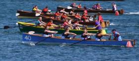
#Rowing: Rushbrooke Rowing Club from Cobh will host the Irish Coastal Rowing Championships next August. It is the first such coastal event to be held under the auspices of Rowing Ireland.

 The decision to choose Rushbrooke was made at the inaugural annual delegate meeting of the new Rowing Ireland Coastal Rowing Division in Portlaoise.

 Rushbrooke submitted a detailed proposal to hold the championships at the National Rowing Centre in Cork and were given unanimous support. Delegates opted for the weekend of August 18th and 19th for the event.

 Ted McSweeney, the chairperson of Rushbrooke Rowing Club said: “This is the greatest honour to be bestowed upon our club. Our club has been in existence since the early 1900s, and although the original club ceased in the late 1960s when the original wooden clubhouse and boats were engulfed by a fire, in 1989, local residents decided to restart the club and agreed on using the Yawl class racing boat. Over the last 28 years, we have gone from strength to strength and have established ourselves as one of the top coastal rowing clubs in Cork.  

 “As a club, we are delighted at the opportunity to host the inaugural Irish Coastal Rowing Championship and will endeavour to deliver an event that will meet the superb standards that have been set over the past few years.  Even at this early stage, we have received immense support, both from the Coastal Rowing community and local organisations. We would like especially to thank the management team at the National Rowing Centre in Farran Woods, who have been exceptionally helpful and forthcoming in assisting us with our bid.  A new chapter in coastal rowing has begun and Rushbrooke Rowing Club will strive to maintain the high standard of regattas that we have been accustomed to. We look forward to welcoming all Coastal Rowers to Cork in 2018 and we can assure you of a Ceád Míle Fáilte.’

 Kieran Kerr, chairperson of the Rowing Ireland Coastal Division, said:  “On behalf of Rowing Ireland, I would like to congratulate Rushbrooke Rowing Club on a very professional bid. We look forward to an exciting inaugural Irish Coastal Rowing Championships.”

Published in Coastal Rowing

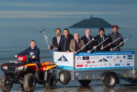
Ballynamona Strand on the East Cork coastline is internationally renowned for a long list of bird life including Shrikes, Larks, Citrine Wagtails, Sandpipers, Pipits, American Coot and Red-necked Stint. There is a new sight to be seen there, writes Tom MacSweeney and it is ensuring that the strand remains a welcoming place for wildlife, seabirds, marine life and for the general public. Regrettably, visitors of the human kind leave litter behind, disregarding the marine environment and despoiling the area.

The local community has responded leading to the new sight on the beach - a quad bike and trailer - showing community dedication to the preservation of a clean maritime environment. It’s the work of the group known as ‘Clean Coasts Ballynamona.’ “Truly an excellent example of what can be achieved when business and community work together,” said Proinsias Ó Tuama, one of the leaders of ‘Clean Coasts’ ‘and a teacher at St.Colman’s Community College, Midleton, where students are also involved in the protection of local beaches. Business and community interests raised €16,000 for a quad bike and trailer to remove beach litter. “It shows how local people are concerned for their maritime environment.”

The Ballynamona group has twice been An Taisce ‘Ocean Hero’ national award winners and has been using the equipment to maintain over 30kms. of coastline by removing marine litter from Ballybranagan to Ballymacoda in East Cork. Five tonnes of rubbish was taken from Ballybranagan beach with the help of the Transition Year students.

Published in Coastal Notes
Tagged under

#Rowing: There is to be a new Coastal Division of Rowing Ireland. At a meeting of the RI board on Saturday, October 21st, the board unanimously acceded to a request from 20 of its affiliated clubs that it form a coastal division. Rowing Ireland has traditionally offered river (Olympic) rowing, and since May of this year has also offered offshore rowing. 

 Hamish Adams, Rowing Ireland CEO, said: “Having seen how successfully offshore rowing has been integrated into Rowing Ireland we believe that adding coastal rowing is a very positive step to expand our product offering and will permit Rowing Ireland to recruit members and develop rowing where river rowing is not possible.” 

 Rowing Ireland will run an Irish Coastal Rowing Championship in 2018, the venue and date of which will be agreed by the clubs at a later date. Kieran Kerr, the chair of the new Coastal Rowing Committee, said that the new coastal division will be club driven and will endeavour to raise the standard of coastal rowing through the provision of coach education and all the other services which Rowing Ireland provides.

Published in Coastal Rowing
Tagged under

#Lecture - Glenua & Friends presents the lecture: The Road to Rio Paralympic Sailing

The talk by Dr. Austin O’Carroll takes place next Thursday 3 November at 20:00 in Poolbeg Yacht & Boat Club Ringsend, Dublin. Entry €5 (in aid of Safetynet)

In 2013 Austin was offered the chance of a place with John Twomey and Ian Costelloe on the Irish Sailing Sonar team which was seeking to qualify for the Rio Paralympics.

In his illustrated talk, Austin will focus on how they forged a team together, followed by a hectic qualifying campaign and finally their experiences of the Paralympic Finals. While involved in this campaign, there was a huge influx of people into homelessness. This meant the medical charity Safetynet, founded by Austin, had to rapidly expand the range of services for homeless people. He will describe how they dealt with this crisis, while running the Paralympic campaign.

Austin’s journey to Rio began in Bere Island in 1982 with a Glenans sailing course. Undaunted by the physical challenges, he was a dinghy instructor by 1984. He is now a GP in Inner City Dublin with a deep interest in Health Inequalities.

In recognition of his work with marginalized groups, he was presented with the Irish Healthcare Person of the year 2015 award and granted an honorary fellowship of the Royal College of Physicians of Ireland. He started eight specialized primary care services for homeless people and founded Safetynet, the umbrella organization for specialized-services for homeless people in Dublin and Cork.

Safetynet has been innovative in the delivery of healthcare to homeless people including rough sleepers; provision of substance misuse treatment to homeless people. He is also involved in a variety of educational programmes dealing in health inequality and disability.

Published in Coastal Notes

#OnTV - The first episode of Bobby Kerr-fronted UTV Ireland series Along Home Shores comes this Thursday 27 October at 7.30pm and explores Dublin’s waterways, with a visit to the famous wallabies of Lambay Island.

Afloat.ie reported last month on filming for the new eight-part-TV series, in which the Insomnia café entrepreneur and avid sailor will discover the hidden treasures of the coastlines and waterways of Ireland.

In each episode, Bobby will examine how people are using the natural resources of our waterways to create employment, while also showcasing the beauty of Ireland along the way. Over eight weeks, he will embrace the heart of maritime communities all over Ireland.

The first episode sees Bobby beginning his journey on his own doorstep of Dublin, where he goes for an early morning swim at the Forty Foot with members of the Sandycove Bathers Association.

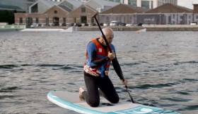
At Grand Canal Dock, he meets a local leisure business and tries paddle boarding for the first time, and Bobby's fitness is put to the test when cancer support group, the Plurabelle Paddlers, bring him dragon boat training.

Eugene Garrihy, the owner of Dublin Bay Cruises, invites Bobby on board his boat to talk business, and he also gets an exclusive invite to the hidden gem of Lambay Island by businessman Michael Bermingham, who is the only supplier of Lambay meat in Ireland.

"I have been truly amazed by the scenic beauty of Ireland's coastline and inland waterways during my filming of Along Home Shores,” said Bobby of his experience making the series.

“The fascinating characters I met along the way were an absolute inspiration to me. Through the prisms of heritage, business and culture, I have now gained a unique insight into Ireland. The sheer magnificence of our coastal and inland waterways, and their people, cannot be overstated."

Beginning his voyage in the capital, Bobby will bring the personality of coastal towns, villages and inland waterways to life as he travels anticlockwise around Ireland before ending his journey back in Dublin.

Future weeks will see him visiting Rathlin Island's seabird colony, kayaking the Causeway Coast, angling on Lough Erne, sailing on Lough Derg, attending the homecoming of Skibbereen's Olympic heroes, cycling the Deise Greenway, going oyster farming, staying overnight in a lighthouse and lots more.

The first episode of Along Home Shores airs this Thursday 27 October at 7.30pm on UTV Ireland. ​

Published in Maritime TV

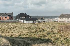
#Surfing - A black rubber roof is one of the unusual features of the winning design for a new maritime centre in Strandhill, as the Sligo Champion reports.

The vision for the new surfing and coastal community centre by London architects Manalo & White also includes large concrete panels around the perimeter with Celtic seascapes and surfing scenes by Barry Britton, whose known as much for his art as for his waveriding legacy – not least being father of women's surfing pioneer Easkey Britton.

A planning application is expected to be completed by the end of April with a view to having the €500,000 facility, which would replace the existing centre used by the local surf club and other groups, ready in time for next year's tourism season.

The Sligo Champion has more on the story HERE.

Published in Surfing
Page 1 of 5

General Information on using Waterways Ireland inland navigations

Safety on the Water

All users of the navigations are strongly recommended to make themselves aware of safety on the water for whatever activity they are involved in and to read the advice offered by the various governing bodies and by:

The Dept. of Transport, Ireland: www.gov.ie/transport and The Maritime and Coastguard Agency, UK, The RNLI – Water Safety Ireland for information in terms of drowning prevention and water safety.

Registration of Vessels

All vessels using the Shannon Navigation, which includes the Shannon-Erne Waterways and the Erne System must be registered with Waterways Ireland. Only open undecked boats with an engine of 15 horsepower or less on the Shannon Navigation, and vessels of 10 horsepower or less on the Erne System, are exempt. Registration is free of charge.

Craft registration should be completed online at: https://www.waterwaysireland.org/online-services/craft-registration

Permits for use of the Grand and Royal Canals and the Barrow Navigation

All vessels using the Grand and Royal Canals and the Barrow Navigation must display appropriate valid Permit(s) i.e A Combined Mooring and Passage Permit (€126) and if not intending to move every five days, an Extended Mooring Permit (€152).

Permit applications should be completed online at: https://www.waterwaysireland.org/online-services/canal-permits

Passage on the Royal and Grand Canals – Dublin Area

For boat passage through the locks east of Lock 12 into / out of Dublin on either the Royal or Grand Canals, Masters are requested to contact the Waterways Ireland Eastern Regional Office (M-F 9.30am-4.30pm) on tel: +353(0)1 868 0148 or email [email protected] prior to making passage in order to plan the necessary lock-keeping assistance arrangements.

On the Grand Canal a minimum of two days notice prior to the planned passage should be given, masters should note that with the exception of pre-arranged events, a maximum of 2 boats per day will be taken through the locks, travelling either east or west.

Movements in or out of the city will be organised by prior arrangement to take place as a single movement in one day. Boaters will be facilitated to travel the system if their passage is considered to be safe by Waterways Ireland and they have the valid permit(s) for mooring and passage.

Newcomen Lifting Bridge

On the Royal Canal two weeks’ notice of bridge passage (Newcomen Lifting Bridge) is required for the pre-set lift date, and lock assistance will then also be arranged. A minimum of 2 boats is required for a bridge lift to go ahead.

Waterways Ireland Eastern Regional Office (Tel: +353(0)1 868 0148 or [email protected] ) is the point of contact for the bridge lift.

A maximum number of boats passing will be implemented to keep to the times given above for the planned lifts (16 for the Sat / Sun lifts & 8 for the weekday lifts). Priority will be given on a first come first served basis.

On day of lift, boaters and passengers must follow guidance from Waterways Ireland staff about sequence of passage under bridge & through Lock 1, and must remain within signed and designated areas.

Events Held on the Waterways

All organised events taking place on the waterways must have the prior approval of Waterways Ireland. This is a twelve week process and application forms must be accompanied with the appropriate insurance, signed indemnity and risk assessment. The application should be completed on the Waterways Ireland events page at :

https://www.waterwaysireland.org/online-services/event-approval

Time Limits on Mooring in Public Harbours

On the Shannon Navigation and the Shannon-Erne Waterway craft may berth in public harbours for five consecutive days or a total of seven days in any one month.

On the Erne System, revised Bye Laws state that: No master or owner shall permit a vessel, boat or any floating or sunken object to remain moored at or in the vicinity of any public mooring, including mooring at any other public mooring within 3 kilometres of that location, for more than 3 consecutive days and shall not moor at that same mooring or any other public mooring within 3 kilometres of that location within the following 3 consecutive days without prior permission by an authorised official.

Winter Mooring on the Shannon Navigation and Shannon Erne Waterway

Winter mooring may be availed of by owners during the period 1 Nov to 31 Mar by prior arrangement and payment of a charge of €63.50 per craft. Craft not availing of Winter Mooring must continue to comply with the “5 Day Rule”. Winter Mooring applications should be completed online at : https://www.waterwaysireland.org/online-services/winter-moorings-booking

Owners should be aware that electricity supply and water supply to public moorings is disconnected for the winter months. This is to protect against frost damage, to reduce running costs and to minimise maintenance requirements during the winter months.

Vessel owners are advised that advance purchasing of electricity on the power bollards leading up to the disconnection date should be minimal. Electricity credit existing on the bollards will not be recoverable after the winter decommissioning date. Both services will be reinstated prior to the commencement of the next boating season.

Smart Cards

Waterways Ireland smart cards are used to operate locks on the Shannon Erne Waterway, to access the service blocks, to use the pump-outs along the navigations, to avail of electrical power at Waterways Ireland jetties.

Berthing in Public Harbours

Masters are reminded of the following:

  • Equip their vessel with mooring lines of appropriate length and strength and only secure their craft to mooring bollards and cleats provided for this purpose.
  • Ensure the available berth is suitable to the length of your vessel, do not overhang the mooring especially on finger moorings on floating pontoon moorings.
  • Ensure mooring lines, electric cables and fresh water hoses do not create a trip hazard on public jetties for others users.
  • Carry sufficient fenders to prevent damage to your own vessel, other vessels and WI property.
  • Allow sufficient space between your vessel and the vessel ahead /astern (c.1m) for fire safety purposes and /or to recover somebody from the water.
  • Do not berth more than two vessels side by side and ensure there is safe access/egress at all times between vessels and onto the harbour itself.
  • Do not berth in such a way to prevent use of harbour safety ladders, slipways or pump-outs.
  • Do not allow the bow of your vessel to overhang the walkway of a floating mooring thus creating a hazard for others with an overhanging anchor or bow fendering.
  • Animals are not allowed to be loose or stray at any time.
  • Harbour and jetty infrastructure such as railings, power pedestals, fresh water taps, electric light poles, safety bollards, ladders etc are not designed for the purpose of mooring craft , they will not bear the strain of a vessel and will be damaged.
  • At Carrybridge on the Erne System, Masters of vessels are not permitted to use stern on mooring. Masters of vessels must use the mooring fingers for mooring of vessels and for embarkation / disembarkation from vessels.

Passenger Vessel Berths

Masters of vessels should not berth on passenger vessel berths where it is indicated that an arrival is imminent. Passenger vessels plying the navigations generally only occupy the berths to embark and disembark passengers and rarely remain on the berths for extended periods or overnight.

Lock Lead-in Jetties

Lead-in jetties adjacent to the upstream and downstream gates at lock chambers are solely for the purpose of craft waiting to use the lock and should not be used for long term berthing.

Vessel Wake

Vessel wake, that is, the wave generated by the passage of the boat through the water, can sometimes be large, powerful and destructive depending on the hull shape and engine power of the vessel. This wake can be detrimental to other users of the navigation when it strikes their craft or inundates the shoreline or riverbank. Masters are requested to frequently look behind and check the effect of their wake / wash particularly when passing moored vessels, on entering harbours and approaching jetties and to be aware of people pursuing other activities such as fishing on the riverbank.

Speed Restriction

A vessel or boat shall not be navigated on the Shannon Navigation at a speed in excess of 5 kph when within 200 metres of a bridge, quay, jetty or wharf, when in a harbour or canal or when passing within 100 metres of a moored vessel or boat.

Vessels navigating the Shannon-Erne Waterway should observe the general 5 kph speed limit which applies along the waterway. This is necessary in order to prevent damage to the banks caused by excessive wash from vessels.

Vessels navigating the Erne System should observe the statutory 5kt / 6mph / 10kph speed limit areas.

A craft on the Royal and Grand canals shall not be navigated at a speed in excess of 6km per hour.

A craft on the Barrow Navigation shall not be navigated at a speed in excess of 11km per hour except as necessary for safe navigation in conditions of fast flow.

Bank Erosion

Narrow sections of all the navigations are particularly prone to bank erosion due to the large wash generated by some craft. Masters are requested to be vigilant and to slow down to a speed sufficient to maintain steerage when they observe the wash of their craft inundating the river banks.

Unusual Waterborne Activity

Unusual waterborne vessels may be encountered from time to time, such as, hovercraft or amphibious aircraft / seaplanes. Masters of such craft are reminded to apply the normal “Rule of the Road” when they meet conventional craft on the water and to allow extra room to manoeuvre in the interest of safety.

Sailing Activity

Mariners will encounter large numbers of sailing dinghies from late June to August in the vicinity of Lough Derg, Lough Ree and Lower Lough Erne. Sailing courses are marked by yellow buoys to suit weather conditions on the day. Vessels should proceed at slow speed and with due caution and observe the rules of navigation when passing these fleets, as many of the participants are junior sailors under training.

Rowing

Mariners should expect to meet canoes and vessels under oars on any part of the navigations, but more so in the vicinity of Athlone, Carrick-on-Shannon, Coleraine, Enniskillen and Limerick. Masters are reminded to proceed at slow speed and especially to reduce their wash to a minimum when passing these craft as they can be easily upset and swamped due to their very low freeboard and always be prepared to give way in any given traffic situation.

Canoeing

Canoeing is an adventure sport and participants are strongly recommended to seek the advice of the sport’s governing bodies i.e Canoeing Ireland and the Canoe Association of Northern Ireland, before venturing onto the navigations.

Persons in charge of canoes are reminded of the inherent danger to these craft associated with operating close to weirs, sluice gates, locks and other infrastructure particularly when rivers are in flood and large volumes of water are moving through the navigations due to general flood conditions or very heavy localised precipitation e.g. turbulent and broken water, stopper waves. Shooting weirs is prohibited without prior permission of Waterways Ireland.

Canoeists should check with lockkeepers prior entering a lock to ensure passage is done in a safe manner. Portage is required at all unmanned locks.

Canoe Trail Network – "Blueways"

Masters of powered craft are reminded that a canoe trail network is being developed across all navigations and to expect more organised canoeing along these trails necessitating slow speed and minimum wash when encountering canoeists, rowing boats etc

Rockingham and Drummans Island Canals – Lough Key

It is expected that work on Rockingham and Drummans Island Canals on Lough Key will be completed in 2021. Access to these canals will be for non-powered craft only, eg canoes, kayaks, rowing boats.

Fast Powerboats and Personal Watercraft (Jet Skis)

Masters of Fast Powerboats (speed greater than 17kts) and Personal Watercraft (i.e.Jet Skis) are reminded of the inherent dangers associated with high speed on the water and especially in the confines of small bays and narrow sections of the navigations. Keeping a proper look-out, making early alterations to course and /or reducing speed will avoid conflict with slower vessels using the navigation. Personal Watercraft are not permitted to be used on the canals.

Towing Waterskiers, Wakeboarders, Doughnuts etc

Masters of vessels engaged in any of these activities are reminded of the manoeuvring constraints imposed upon their vessel by the tow and of the added responsibilities that they have to the person(s) being towed. These activities should be conducted in areas which are clear of conflicting traffic. It is highly recommended that a person additional to the master be carried to act as a “look-out” to keep the tow under observation at all times.

Prohibition on Swimming

Swimming in the navigable channel, particularly at bridges, is dangerous and is prohibited due to the risk of being run over by a vessel underway in the navigation.

Age Restrictions on operating of powered craft

In the Republic of Ireland, Statutory Instrument 921 of 2005 provides the legal requirements regarding the minimum age for operating of powered craft. The Statutory Instrument contains the following requirements:

- The master or owner of a personal watercraft or a fast power craft shall take all reasonable steps to ensure that a person who has not attained the age of 16 years does not operate or control the craft

- The master or owner of a pleasure craft powered by an engine with a rating of more than 5 horse power or 3.7 kilowatts shall take all reasonable steps to ensure that a person who has not attained the age of 12 years does not operate or control the craft.

Lifejackets and Personal Flotation Devices (PFDs)

Lifejackets and PFD’s are the single most important items of personal protective equipment to be used on a vessel and should be worn especially when the vessel is being manoeuvred such as entering / departing a lock, anchoring, coming alongside or departing a jetty or quayside.

In the Republic of Ireland, Statutory Instrument 921 of 2005 provides the legal requirements regarding the wearing of Personal Flotation Devices. The Statutory Instrument contains the following requirements:

- The master or owner of a pleasure craft (other than a personal watercraft) shall ensure, that there are, at all times on board the craft, sufficient suitable personal flotation devices for each person on board.

- A person on a pleasure craft (other than a personal watercraft) of less than 7 metres length overall shall wear a suitable personal flotation device while on board an open craft or while on the deck of decked craft, other than when the craft is made fast to the shore or at anchor.

- The master or owner of a pleasure craft (other than a personal watercraft) shall take all reasonable steps to ensure that a person who has not attained the age of 16 years complies with paragraph above.

- The master or owner of a pleasure craft (other than a personal watercraft), shall take all reasonable steps to ensure that a person who has not attained the age of 16 years wears a suitable personal flotation device while on board an open craft or while on the deck of a decked craft other than when it is made fast to the shore or at anchor.

- The master or owner of a pleasure craft (other than a personal watercraft) shall take all reasonable steps to ensure that a person wears a suitable personal flotation device, at all times while – (a) being towed by the craft, (b) on board a vessel or object of any kind which is being towed by the craft.

Further information is available at: http://www.irishstatutebook.ie/eli/2005/si/921/made/en/print

Firing Range Danger Area – Lough Ree

The attention of mariners is drawn to the Irish Defence Forces Firing Range situated in the vicinity of buoys No’s 2 and 3, on Lough Ree on the Shannon Navigation. This range is used regularly for live firing exercises, throughout the year, all boats and vessels should stay clear of the area marked with yellow buoys showing a yellow "X" topmark and displaying the word "Danger".

Shannon Navigation, Portumna Swing Bridge Tolls

No attempt should be made by Masters’ of vessels to pay the bridge toll while making way through the bridge opening. Payment will only be taken by the Collector from Masters when they are secured alongside the jetties north and south of the bridge.

Navigating from Killaloe to Limerick on the Shannon Navigation

The navigation from Killaloe to Limerick involves passage through Ardnacrusha locks, the associated headrace and tailrace and the Abbey River into Limerick City. Careful passage planning is required to undertake this voyage. Considerations include: lock passage at Ardnacrusha, water flow in the navigation, airdraft under bridges on Abbey River in Limerick, state of tide in Limerick

Users are advised to contact the ESB Ardnacrusha hydroelectric power station (00353 (0)87 9970131) 48 hours in advance of commencing their journey to book passage through the locks at Ardnacrusha. It is NOT advised to undertake a voyage if more than one turbine is operating (20MW), due to the increased velocity of flow in the navigation channel, which can be dangerous. To ascertain automatically in real time how many turbines are running, users can phone +353 (0)87 6477229.

For safety reasons the ESB has advised that only powered craft with a capacity in excess of 5 knots are allowed to enter Ardnacrusha Headrace and Tailrace Canals.

Passage through Sarsfield Lock should be booked on +353-87-7972998, on the day prior to travel and it should be noted also that transit is not possible two hours either side of low water.

A Hydrographic survey in 2020 of the navigation channel revealed that the approach from Shannon Bridge to Sarsfield Lock and the Dock area has silted up. Masters of vessels and water users are advised to navigate to the Lock from Shannon bridge on a rising tide one or two hours before High Tide.

Lower Bann Navigation

The attention of all users is drawn to the “Users Code for the Lower Bann”, in particular to that section covering “Flow in the River” outlining the dangers for users both on the banks and in the navigation, associated with high flow rates when the river is in spate. Canoeists should consult and carry a copy of the “Lower Bann Canoe Trail” guide issued by the Canoe Association of Northern Ireland. Users should also contact the DfI Rivers Coleraine, who is responsible for regulating the flow rates on the river, for advisory information on the flow rates to be expected on any given day.

DfI Rivers Coleraine. Tel: 0044 28 7034 2357 Email: [email protected]

Lower Bann Navigation – Newferry – No wake zone

A No Wake Zone exists on the Lower Bann Navigation at Newferry. Masters of vessels are requested to proceed at a slow speed and create no wake while passing the jetties and slipways at Newferry.

Overhead Power Lines (OHPL) and Air draft

All Masters must be aware of the dangers associated with overhead power lines, in particular sailing vessels and workboats with cranes or large air drafts. Voyage planning is a necessity in order to identify the location of overhead lines crossing the navigation.

Overhead power line heights on the River Shannon are maintained at 12.6metres (40 feet) from Normal Summer level for that section of navigation, masters of vessels with a large air draft should proceed with caution and make additional allowances when water levels are high.

If a vessel or its equipment comes into contact with an OHPL the operator should NOT attempt to move the vessel or equipment. The conductor may still be alive or re-energise automatically. Maintain a safe distance and prevent third parties from approaching due to risk of arcing. Contact the emergency services for assistance.

Anglers are also reminded that a minimum ground distance of 30 metres should be maintained from overhead power lines when using a rod and line.

Submarine Cables and Pipes

Masters of vessels are reminded not to anchor their vessels in the vicinity of submarine cables or pipes in case they foul their anchor or damage the cables or pipes. Look to the river banks for signage indicating their presence.

Water Levels - Precautions

Low Water Levels:

When water levels fall below normal summer levels masters should be aware of:

Navigation

To reduce the risk of grounding masters should navigate on or near the centreline of the channel, avoid short cutting in dog-legged channels and navigating too close to navigation markers.

Proceeding at a slow speed will also reduce “squat” effect i.e. where the vessel tends to sit lower in the water as a consequence of higher speed.

Slipways

Reduced slipway length available under the water surface and the possibility of launching trailers dropping off the end of the concrete apron.

More slipway surface susceptible to weed growth requiring care while engaged in launching boats, from slipping and sliding on the slope. Note also that launching vehicles may not be able to get sufficient traction on the slipway once the craft is launched to get up the incline.

Bank Erosion

Very dry riverbanks are more susceptible to erosion from vessel wash.

Lock Share

Maximising on the number of vessels in a lock will ensure that the total volume of water moving downstream is decreased. Lock cycles should be used for vessels travelling each way.

High Water Levels:

When water levels rise above normal summer level masters should be aware of:

Navigation

Navigation marks will have reduced height above the water level or may disappear underwater altogether making the navigable channel difficult to discern.

In narrow sections of the navigations water levels will tend to rise more quickly than in main streams and air draft at bridges will likewise be reduced.

There will also be increased flow rates particularly in the vicinity of navigation infrastructure such as bridges, weirs, locks etc where extra care in manoeuvring vessels will be required.

Harbours and Jetties

Due care is required in harbours and at slipways when levels are at or near the same level as the harbour walkways' as the edge will be difficult to discern especially in reduced light conditions. It is advised that Personal Flotation Devices be worn if tending to craft in a harbour in these conditions.

Slipways

Slipways should only be used for the purpose of launching and recovering of water craft or other objects from the water. Before using a slipway it should be examined to ensure that the surface has sufficient traction/grip for the intended purpose such as launching a craft from a trailer using a vehicle, that there is sufficient depth of water on the slipway to float the craft off the trailer before the concrete apron ends and that the wheels of the trailer do not drop off the edge of the slipway. That life-saving appliances are available in the vicinity, that the vehicle is roadworthy and capable of coping with the weight of the trailer and boat on the incline. It is recommended that slipway operations are conducted by two persons.

Caution to be Used in Reliance upon Aids to Navigation

The aids to navigation depicted on the navigation guides comprise a system of fixed and floating aids to navigation. Prudent mariners will not rely solely on any single aid to navigation, particularly a floating aid to navigation. With respect to buoys, the buoy symbol is used to indicate the approximate position of the buoy body and the ground tackle which secures it to the lake or river bed. The approximate position is used because of the practical limitations in positioning and maintaining buoys in precise geographical locations. These limitations include, but are not limited to, prevailing atmospheric and lake/river conditions, the slope of and the material making up the lake/river bed, the fact that the buoys are moored to varying lengths of chain, and the fact that the buoy body and/or ground tackle positions are not under continuous surveillance. Due to the forces of nature, the position of the buoy body can be expected to shift inside and outside the charted symbol.

Buoys and perches are also moved out of position or pulled over by those mariners who use them to moor up to instead of anchoring. To this end, mariners should always monitor their passage by relating buoy/perch positions with the published navigation guide. Furthermore, a vessel attempting to pass close by always risks collision with a yawing buoy or with the obstruction that the buoy or beacon/perch marks.

Masters of Vessels are requested to use the most up to date Navigation guides when navigating on the Inland Waterways.

Information taken from Special Marine Notice No 1 of 2023