Menu

Ireland's sailing, boating & maritime magazine

Inland afloat headers


Displaying items by tag: Atlantic

A Welshman in his 50s has been found dead on his boat during an attempt to row solo across the Atlantic, as BBC News reports.

Michael Holt had set out from Gran Canaria on 27 January with the aim of reaching Barbados in the Caribbean on a charity fundraiser voyage he expected to take between 50 and 110 days.

But less than four weeks and 700 miles into the challenge, the 54-year-old reported feeling seasick which he attributed to a bad reaction to antibiotics, and he rerouted towards Cape Verde some 300 miles south.

Fears for his welfare grew when contact was lost last week, and on Sunday evening (25 February) his death was announced online.

Holt, who had type 1 diabetes, was found dead in the cabin of his ocean-going rowboat by the crew of a fishing vessel that answered an emergency call.

BBC News has more on the story HERE.

Published in Coastal Rowing
Tagged under

A key Atlantic ocean circulation system regulating temperature is “on route to tipping”, a new study warns.

The European climate is greatly affected by the Atlantic meridional overturning circulation (AMOC), and research by Dutch scientists indicates that it is already on track towards a sharp shift.

Ireland’s climate could become similar to Iceland, Fianna Fáil senator Thomas Byrne has warned.

As the paper by University of Utrecht scientists in the journal Science Advances explains,the AMOC is an ocean circulation system extending from the Tropics up to the Arctic Circle, which transports heat, salt and nutrients.

It can be affected by input of freshwater in the north Atlantic, and rapid melting of Greenland’s glaciers and Arctic ice sheets may already be slowing the course of the warm ocean water from the south.

The last collapse of AMOC is believed to have occurred over 10,000 years ago, and any repeat would have serious consequences for many parts of the globe.

The scientists fed in results of the first “tipping event” into a community earth system model which included the “large climate impacts” of a collapse.

“Using these results, we develop a physics-based and observable early warning signal of AMOC tipping,”they explain.

“Reanalysis products indicate that the present-day AMOC is on route to tipping,”they state.

“The collapse of AMOC – while it may not be something that happens in our lifetime – would have serious consequences for future Irish generations,”Senator Thomas Byrne said in the Senate.

It could result in Ireland’s climate changing to become similar to Iceland’s, which is something that will have profound implications,”he said, warning that Ireland needed to prepare for such an event.

The study by Dr René van Westen, Michael Kliphuis and Henk A. Dijkstra of the Institute for Marine and Atmospheric Research at Utrecht University is published in Science Advances here

Published in Marine Science
Tagged under

The almost absurdly picturesque township of Westport at the head of Clew Bay has been variously acknowledged and nationally recognised as “Ireland’s Best Place to Visit”, and Ireland’s “Best Place to Live”. Even if dedicated misanthropes would argue that any self-respecting township - however lively and easy it is on the eye – simply can’t be both at once, there’s no doubting that hospitable and facilities-rich Westport has an impressive array of factors in its favour.

Yet this only adds to the frustration of cruising folk making their way along Ireland’s Atlantic seaboard, when they make a diversion into island-studded Clew Bay in the hope of savouring Westport’s numerous charms. For Clew Bay’s many islands – with a host of secret anchorages among them – are simply too much of a good thing.

There are so many islands and sheltered anchorages at the head of Clew BayToo much of a good thing? There are so many islands and sheltered anchorages at the head of Clew Bay that it’s difficult deciding which is the most convenient for accessing Westport (lower right)

Thus it has ended up with the thriving Mayo Sailing Club having its well-furnished base at relatively remote Rosmoney, hidden among the islands and inlets a good 9.2 kilometres northwestward from Westport. Other anchorages conveniently reached from sea are wellnigh inaccessible by land unless you’re in the know on where certain tree-lined un-signed boreens are leading. And while the obvious and most direct seaward access point to Westport is to berth at Westport Quay, much of that ancient port dries or has shallow depths at low water.

Chartlet of Westport Quay – even with a berth here, you are still 3 kilometres from Westport town. Courtesy Irish Cruising Club

And anyway, Westport Quay is itself more than 3 kilometres from Westport itself, which can seem a challengingly long distance if you’d like to amble into town, but have walked no further than the length of a cruising boat’s deck for the past week. That said, Westport Quay is an attractively bustling and hospitable community in its own right, quite enough of a destination in its individuality for many of us. And if you want to hit the bright lights of the big city at Westport itself, it’s only a modest taxi fare to reach one of the best nights on the town Ireland has to offer, if you could only be secure in the knowledge that your boat is safely berthed back in Westport Quay.

But with its uneven depths and large tidal range, Westport Quay cannot provide that guarantee. So not surprisingly, noted Clew Bay sailor Alex Blackwell – better known for his ocean voyaging – has been spending some of his time at home in Mayo during the past decade and more in sussing out the possibilities of providing acceptable modern berthing at Westport Quay, complete with the expected facilities such as a Travelhoist.

Ocean voyagers Alex and Daria Blackwell of Clew Bay. While they keep their 57ft ketch Aleria in a secret anchorage among Clew Bay’s mny islands, Alex is well aware that visiting boats need more immediate access to shoreside facilities

Having built up a cohort of like-minded folk in favour of the idea, they have recently been presenting the idea to stakeholders including the local community, tourist interests, boating enthusiasts, the Chamber of Commerce and Mayo County Council, and they’ve been much encouraged by the favourable response.

The scheme – which could in its entirety provide 130 berths – is in two parts. The first phase depends on the installation of a proper sea lock – not a time-constricting tidal gate – at the west end of the river-like stretch of the harbour beside Westport Quay’s attractive waterfront. Provided the sea lock can offer extensive time options for access to the lower channel (which admittedly has shoal sections) and the open sea beyond, it will give significant freedom of movement for boats based in the enclosed berths, pontoon berths which can be provided without the need for extensive and expensive dredging.

Phase 1 of Westport Marina would be provided by a tidal retention barrier and a sea lock.

Phase 2 is the more ambitious project of dredging the lagoon area close to the westward, immediately south of Roman Island. This is a major concept, as it includes a multi-berth accessible-all-tides marina and 40 acres of recreational water right beside the heart of Westport Quay.

The much more ambitious Phase 2 would involved dredging, but it would provide highly-accessible recreational water space in addition to extra all-tide berths

From the wandering cruising person’s point of view, the possibility of a secure berth in the heart of civilisation will offer an attractive change from the rugged offshore islands and remote anchorages which fill much of the menu in a Connacht cruise. And from a strategic point of view, Westport is one of the most westerly points providing direct access to Ireland’s railway network. Longer term berthing in a marina at Westport Quay would offer all sorts of fresh and accessible cruising possibilities on the Atlantic seaboard from most of Ireland’s major conurbations.

Be warned, however, that if you rail your way down to Westport with a crew just let off the leash after some intensive weeks of work, it may take a will of iron to head immediately to the boat from the train, instead of pausing “just for a minute” to savour the entertainments of Westport in a place like Matt Molloy’s. For he’s a sailing man himself, and you know what it’s like when people get talking about boats.

Matt Molloy of Westport – he would as soon talk about boats as his famous music

Published in Irish Marinas
Tagged under

Sailor, kayaker and climber Dr Karen Weekes is training to become the first Irish female to row solo across the Atlantic.

As Times.ie reports, Weekes aims to set out in December of this year to row 3,000 miles from La Gomera in the Canaries to Antigua in the Caribbean.

If she completes it, Weekes will be only the 20th woman to row any ocean on the globe solo.

Weekes, who is from Kilkenny and lives in Kinvara, Co Galway, holds a doctorate in sports psychology, and lectures at Munster Technological University.

She has sailed the Atlantic twice, circumnavigated both Ireland and the Lofoten Islands off Norway in a kayak, and has cycled solo and unsupported 4,000 miles across Canada, through Alaska and the Yukon.

She has also solo cycled from Nordkapp in northern Norway to Helsinki in Finland.

Along with Orla Knight, a physical education teacher at Castletroy College in Co Limerick, she cycled across North America from San Francisco to Washington DC.

Weekes has trekked in Nepal and Pakistan and climbed Mount Kilimanjaro and Mount Kenya.

“Big seas, potential capsize, severe weather or marlin attacks” might explain why only 19 women world-wide have ever completed solo ocean rows, she says of her latest adventure.

Weekes focuses on women’s empowerment as part of her “#shecando2021” campaign, which is seeking sponsors for the effort.

She says the campaign is “dually focused”, in following her preparation for, and experience during the voyage, and “providing a platform for encouraging women, and girls, to believe in their abilities to succeed”.

Read more on Times.ie here

Published in Coastal Rowing
Tagged under

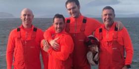
#Rowing: Home to Portrush and Relentless, from Cork and Dublin, look set to finish the Atlantic Challenge race in under a week. The Northern Irish crew has taken a clear fifth place and are putting in good mileage each day – they covered 88 nautical miles (163 kilometres) moving into the 27th day of the race from the Canary Islands to Antigua. The crew of George McAlpin, Ally Cooper, Gareth Barton and Luke Baker had 459 nautical miles (850 km) to the finish.

 One place behind them lie another four, Relentless. The Cork/Dublin crew have also benefitted from the favourable winds. If they continue their fine progress they will land in English Harbour in Antigua just one day after Home to Portrush, on January 15th.

 Solo oarsman Damian Browne has crossed the 1,000 nautical mile mark and has been punching in very steady times after coming through capsizes, an injured face and a damaged steering system. The Galway man, who rows as Gullivers Travels, is projected to finish on Valentine’s Day, February 14th.

Published in Rowing

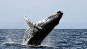
#Rowing: Damian Browne twice capsized and suffered facial injuries but has continued to row in the Atlantic Challenge race. The Galway man, who competes as Gullivers Travels, posted a remarkable video on his Facebook page below telling of how he had been woken by his face “getting smashed off the side of the cabin”. He made light of the cut, which bled profusely, and the other injuries. The hours following brought another capsize and sighting of a whale which circled his boat and made eye contact with him. Browne and the two other boats from Ireland in the race, Relentless and Home to Portrush, are two weeks into the race from the Canary Islands to Antigua.

Published in Rowing

#Rowing - Dubliner Brian Conville is recovering in Tralee Hospital after being rescued by the Irish Coast Guard about 160 miles off Mizen Head this afternoon, writes Tom MacSweeney.

Experienced offshore rower Conville, 25 — who last year crossed the Pacific Ocean from California to Hawaii over 48 days — had been attempting to set a west-to-east record from Newfoundland with Joseph Gagnon, a 20-year-old science student from Quebec.

They set off from St John’s Harbour in Newfoundland a fortnight ago, originally intending to head for France, but had changed their plans and rerouted for the Irish coast, hoping to reach West Cork within the next few days.

Those plans were scuppered this morning when the pair’s boat overturned, activating its EPIRB signal which was picked up by Valentia Coast Guard.

Waterford’s coastguard helicopter Rescue 117 was quickly dispatched for a successful airlift of the two casualties, who have been treated for mild hypothermia but are said to be in good spirits, according to RTÉ News.

Speaking about the rescue, the Irish Coast Guard’s Gerard O’Flynn said: “It highlights that if you can raise the alarm and stay afloat, then you stand a very good chance of being rescued. 

“I also want to compliment the helicopter crew and Valentia [station] on a very successful operation and thank the Air Corps for their support.”

Had Conville and Gagnon completed their voyage, they would have been the second Atlantic record-setters this year after solo rower Gavan Hennigan paddled in the Talisker Whisky Atlantic Challenge this past February.

Published in Rowing
Tagged under

#ClimateChange - Preliminary results from the recent ‘health check’ of the Atlantic Ocean suggest a greater penetration of manmade chlorofluorocarbons (CFCs) further into the deeper ocean since 20 years ago.

As previously reported on Afloat.ie, an Irish-led international team of marine scientists from six countries set out from Newfoundland on 27 April on board the RV Celtic Explorer, to survey a transect of the Atlantic last measured two decades ago and investigate the impact of climate change on the deep ocean.

Explaining the team’s findings, Dr Evin McGovern of the Marine Institute and principal investigator on the GO-SHIP A02 survey said: “Although these chemicals have been phased out, they remain in the atmosphere and enter the ocean, where over time, they travel to the deep ocean.

“We measure the CFCs to tell the age of the water masses in the deep ocean and this helps us assess the uptake of fossil fuel carbon from the atmosphere and penetration into the deep ocean.”

The survey formed part of the Global Oceans Ship-Based Hydrographic Investigations Programme (GO-SHIP), which carries out systematic and global surveys of select hydrographic sections, through an international consortium of 16 countries and laboratories.

This was the first GO-SHIP survey to involve such a level of collaboration, with scientists from 10 leading universities and research institutes representing six countries.

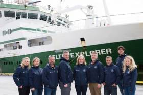
Canadian Ambassador to Ireland Kevin Vickers visited the RV Celtic Explorer to meet the team in Galway following their arrival on Monday 22 May.

“This survey is a wonderful example of the Galway Statement in action as well as the longstanding collaboration on marine research between Ireland and Canada,” he said.

Marine Institute chief executive Dr Peter Heffernan added that the expedition’s scientists “are contributing to addressing some of the biggest questions for society and our interaction with our planet.”

Find out more about the survey on the Scientists@Sea blog, where the GO-SHIP team aboard the RV Celtic Explorer recorded their work and experiences.

Published in Marine Science

#Offshore - Offshore yachts beware this summer after three British sailors had a lucky escape when their yacht collided with a whale and sank in the mid Atlantic.

According to Independent.ie, the trio from the Destiny of Scarborough were picked up by a merchant vessel some 400 miles north east of the Azores this past Sunday (21 May).

The Portuguese navy also dispatched to the location after receiving the yacht’s distress signal, but the men were safely returned to land at Aviles in Spain by the merchant ship.

Published in Offshore
Tagged under

#MarineScience - An international team of marine scientists from six countries are currently sailing on Ireland’s national research vessel RV Celtic Explorer on a transatlantic voyage to study the impact of climate change on the ocean.

Departing from St John’s in Newfoundland on Thursday 27 April — after launching the miniature yacht Lancer a few days previously — and due to arrive in Galway on 23 May, the Marine Institute-led team of experts are surveying a transect of the Atlantic Ocean last surveyed 20 years ago to investigate carbon dioxide levels in the ocean.

The survey is essential to understand and project how carbon dioxide emissions are accumulated in the oceans and the atmosphere, as well as its effects on the acidification of the ocean.

The survey is part of the Global Oceans Ship-Based Hydrographic Investigations Program (GO-SHIP), which carries out systematic and global surveys of select hydrographic sections, through an international consortium of 16 countries and laboratories.

This is the first GO-SHIP survey to involve this level of collaboration with scientists from ten leading universities and research institutes representing six countries joining the survey.

Marine Institute chief executive Dr Peter Heffernan said: “The Marine Institute is proud to lead this truly international collaboration. This GO-SHIP A02 survey is a very real example of the Galway Statement in action: working together to better understand and increase our knowledge of the Atlantic Ocean and its dynamic systems, and promoting the sustainable management of its resources.”

The Galway Statement, signed at the Marine Institute 24 May 2013, launched the Atlantic Ocean Research Alliance between the EU, Canada and the USA.

The survey is co-ordinated by the Marine Institute and NUI Galway with research partners in Dalhousie University and Fisheries and Oceans, Canada; University of Exeter, United Kingdom; GEOMAR, Germany; Woods Hole Oceanographic Institution and Columbia University, USA; and Aarhus University, Denmark.

“Ship-based surveys are still the only way to collect the best quality measurements of fundamental physical, chemical and biological properties known as Essential Ocean Variables,” said Dr Evin McGovern of the Marine Institute and principal investigator on the GO-SHIP A02 survey.

“Although technology has provided many new methods to collect ocean measurements, there’s really no substitute for going out on the ocean on a research vessel.

“We can use satellite technology to look at certain properties the ocean surface and can deploy autonomous argo floats to take some measurements to depths of 2000, but we need to carry out ocean surveys that can measure to get a complete picture of the chemistry of the ocean at different depths up to 5,000m.

“The transect we are surveying is a really dynamic area of the Atlantic for heat transport and carbon uptake and is hugely important to informing our understanding of our global climate and how the ocean regulates our climate,” added Dr McGovern.

“The Northwest Atlantic is one of the world’s largest sinks of carbon dioxide and despite progress in our understanding there’s still a huge lack of data as it relates to climate change’s impact on the ocean and what that means for the economy and society,” said Brad de Young, a professor of physics and physical oceanography at Memorial University, Newfoundland and an Ocean Frontier Institute researcher.

“Improving our scientific understanding and developing strategic and effective solutions for safe and sustainable ocean development requires sharing of expertise, international co-operation and exchange of data and best practices. And that’s what this voyage is all about,” adds Doug Wallace, Canada Excellence research chair at Dalhousie University.

Published in Marine Science
Page 1 of 7

General Information on using Waterways Ireland inland navigations

Safety on the Water

All users of the navigations are strongly recommended to make themselves aware of safety on the water for whatever activity they are involved in and to read the advice offered by the various governing bodies and by:

The Dept. of Transport, Ireland: www.gov.ie/transport and The Maritime and Coastguard Agency, UK, The RNLI – Water Safety Ireland for information in terms of drowning prevention and water safety.

Registration of Vessels

All vessels using the Shannon Navigation, which includes the Shannon-Erne Waterways and the Erne System must be registered with Waterways Ireland. Only open undecked boats with an engine of 15 horsepower or less on the Shannon Navigation, and vessels of 10 horsepower or less on the Erne System, are exempt. Registration is free of charge.

Craft registration should be completed online at: https://www.waterwaysireland.org/online-services/craft-registration

Permits for use of the Grand and Royal Canals and the Barrow Navigation

All vessels using the Grand and Royal Canals and the Barrow Navigation must display appropriate valid Permit(s) i.e A Combined Mooring and Passage Permit (€126) and if not intending to move every five days, an Extended Mooring Permit (€152).

Permit applications should be completed online at: https://www.waterwaysireland.org/online-services/canal-permits

Passage on the Royal and Grand Canals – Dublin Area

For boat passage through the locks east of Lock 12 into / out of Dublin on either the Royal or Grand Canals, Masters are requested to contact the Waterways Ireland Eastern Regional Office (M-F 9.30am-4.30pm) on tel: +353(0)1 868 0148 or email [email protected] prior to making passage in order to plan the necessary lock-keeping assistance arrangements.

On the Grand Canal a minimum of two days notice prior to the planned passage should be given, masters should note that with the exception of pre-arranged events, a maximum of 2 boats per day will be taken through the locks, travelling either east or west.

Movements in or out of the city will be organised by prior arrangement to take place as a single movement in one day. Boaters will be facilitated to travel the system if their passage is considered to be safe by Waterways Ireland and they have the valid permit(s) for mooring and passage.

Newcomen Lifting Bridge

On the Royal Canal two weeks’ notice of bridge passage (Newcomen Lifting Bridge) is required for the pre-set lift date, and lock assistance will then also be arranged. A minimum of 2 boats is required for a bridge lift to go ahead.

Waterways Ireland Eastern Regional Office (Tel: +353(0)1 868 0148 or [email protected] ) is the point of contact for the bridge lift.

A maximum number of boats passing will be implemented to keep to the times given above for the planned lifts (16 for the Sat / Sun lifts & 8 for the weekday lifts). Priority will be given on a first come first served basis.

On day of lift, boaters and passengers must follow guidance from Waterways Ireland staff about sequence of passage under bridge & through Lock 1, and must remain within signed and designated areas.

Events Held on the Waterways

All organised events taking place on the waterways must have the prior approval of Waterways Ireland. This is a twelve week process and application forms must be accompanied with the appropriate insurance, signed indemnity and risk assessment. The application should be completed on the Waterways Ireland events page at :

https://www.waterwaysireland.org/online-services/event-approval

Time Limits on Mooring in Public Harbours

On the Shannon Navigation and the Shannon-Erne Waterway craft may berth in public harbours for five consecutive days or a total of seven days in any one month.

On the Erne System, revised Bye Laws state that: No master or owner shall permit a vessel, boat or any floating or sunken object to remain moored at or in the vicinity of any public mooring, including mooring at any other public mooring within 3 kilometres of that location, for more than 3 consecutive days and shall not moor at that same mooring or any other public mooring within 3 kilometres of that location within the following 3 consecutive days without prior permission by an authorised official.

Winter Mooring on the Shannon Navigation and Shannon Erne Waterway

Winter mooring may be availed of by owners during the period 1 Nov to 31 Mar by prior arrangement and payment of a charge of €63.50 per craft. Craft not availing of Winter Mooring must continue to comply with the “5 Day Rule”. Winter Mooring applications should be completed online at : https://www.waterwaysireland.org/online-services/winter-moorings-booking

Owners should be aware that electricity supply and water supply to public moorings is disconnected for the winter months. This is to protect against frost damage, to reduce running costs and to minimise maintenance requirements during the winter months.

Vessel owners are advised that advance purchasing of electricity on the power bollards leading up to the disconnection date should be minimal. Electricity credit existing on the bollards will not be recoverable after the winter decommissioning date. Both services will be reinstated prior to the commencement of the next boating season.

Smart Cards

Waterways Ireland smart cards are used to operate locks on the Shannon Erne Waterway, to access the service blocks, to use the pump-outs along the navigations, to avail of electrical power at Waterways Ireland jetties.

Berthing in Public Harbours

Masters are reminded of the following:

  • Equip their vessel with mooring lines of appropriate length and strength and only secure their craft to mooring bollards and cleats provided for this purpose.
  • Ensure the available berth is suitable to the length of your vessel, do not overhang the mooring especially on finger moorings on floating pontoon moorings.
  • Ensure mooring lines, electric cables and fresh water hoses do not create a trip hazard on public jetties for others users.
  • Carry sufficient fenders to prevent damage to your own vessel, other vessels and WI property.
  • Allow sufficient space between your vessel and the vessel ahead /astern (c.1m) for fire safety purposes and /or to recover somebody from the water.
  • Do not berth more than two vessels side by side and ensure there is safe access/egress at all times between vessels and onto the harbour itself.
  • Do not berth in such a way to prevent use of harbour safety ladders, slipways or pump-outs.
  • Do not allow the bow of your vessel to overhang the walkway of a floating mooring thus creating a hazard for others with an overhanging anchor or bow fendering.
  • Animals are not allowed to be loose or stray at any time.
  • Harbour and jetty infrastructure such as railings, power pedestals, fresh water taps, electric light poles, safety bollards, ladders etc are not designed for the purpose of mooring craft , they will not bear the strain of a vessel and will be damaged.
  • At Carrybridge on the Erne System, Masters of vessels are not permitted to use stern on mooring. Masters of vessels must use the mooring fingers for mooring of vessels and for embarkation / disembarkation from vessels.

Passenger Vessel Berths

Masters of vessels should not berth on passenger vessel berths where it is indicated that an arrival is imminent. Passenger vessels plying the navigations generally only occupy the berths to embark and disembark passengers and rarely remain on the berths for extended periods or overnight.

Lock Lead-in Jetties

Lead-in jetties adjacent to the upstream and downstream gates at lock chambers are solely for the purpose of craft waiting to use the lock and should not be used for long term berthing.

Vessel Wake

Vessel wake, that is, the wave generated by the passage of the boat through the water, can sometimes be large, powerful and destructive depending on the hull shape and engine power of the vessel. This wake can be detrimental to other users of the navigation when it strikes their craft or inundates the shoreline or riverbank. Masters are requested to frequently look behind and check the effect of their wake / wash particularly when passing moored vessels, on entering harbours and approaching jetties and to be aware of people pursuing other activities such as fishing on the riverbank.

Speed Restriction

A vessel or boat shall not be navigated on the Shannon Navigation at a speed in excess of 5 kph when within 200 metres of a bridge, quay, jetty or wharf, when in a harbour or canal or when passing within 100 metres of a moored vessel or boat.

Vessels navigating the Shannon-Erne Waterway should observe the general 5 kph speed limit which applies along the waterway. This is necessary in order to prevent damage to the banks caused by excessive wash from vessels.

Vessels navigating the Erne System should observe the statutory 5kt / 6mph / 10kph speed limit areas.

A craft on the Royal and Grand canals shall not be navigated at a speed in excess of 6km per hour.

A craft on the Barrow Navigation shall not be navigated at a speed in excess of 11km per hour except as necessary for safe navigation in conditions of fast flow.

Bank Erosion

Narrow sections of all the navigations are particularly prone to bank erosion due to the large wash generated by some craft. Masters are requested to be vigilant and to slow down to a speed sufficient to maintain steerage when they observe the wash of their craft inundating the river banks.

Unusual Waterborne Activity

Unusual waterborne vessels may be encountered from time to time, such as, hovercraft or amphibious aircraft / seaplanes. Masters of such craft are reminded to apply the normal “Rule of the Road” when they meet conventional craft on the water and to allow extra room to manoeuvre in the interest of safety.

Sailing Activity

Mariners will encounter large numbers of sailing dinghies from late June to August in the vicinity of Lough Derg, Lough Ree and Lower Lough Erne. Sailing courses are marked by yellow buoys to suit weather conditions on the day. Vessels should proceed at slow speed and with due caution and observe the rules of navigation when passing these fleets, as many of the participants are junior sailors under training.

Rowing

Mariners should expect to meet canoes and vessels under oars on any part of the navigations, but more so in the vicinity of Athlone, Carrick-on-Shannon, Coleraine, Enniskillen and Limerick. Masters are reminded to proceed at slow speed and especially to reduce their wash to a minimum when passing these craft as they can be easily upset and swamped due to their very low freeboard and always be prepared to give way in any given traffic situation.

Canoeing

Canoeing is an adventure sport and participants are strongly recommended to seek the advice of the sport’s governing bodies i.e Canoeing Ireland and the Canoe Association of Northern Ireland, before venturing onto the navigations.

Persons in charge of canoes are reminded of the inherent danger to these craft associated with operating close to weirs, sluice gates, locks and other infrastructure particularly when rivers are in flood and large volumes of water are moving through the navigations due to general flood conditions or very heavy localised precipitation e.g. turbulent and broken water, stopper waves. Shooting weirs is prohibited without prior permission of Waterways Ireland.

Canoeists should check with lockkeepers prior entering a lock to ensure passage is done in a safe manner. Portage is required at all unmanned locks.

Canoe Trail Network – "Blueways"

Masters of powered craft are reminded that a canoe trail network is being developed across all navigations and to expect more organised canoeing along these trails necessitating slow speed and minimum wash when encountering canoeists, rowing boats etc

Rockingham and Drummans Island Canals – Lough Key

It is expected that work on Rockingham and Drummans Island Canals on Lough Key will be completed in 2021. Access to these canals will be for non-powered craft only, eg canoes, kayaks, rowing boats.

Fast Powerboats and Personal Watercraft (Jet Skis)

Masters of Fast Powerboats (speed greater than 17kts) and Personal Watercraft (i.e.Jet Skis) are reminded of the inherent dangers associated with high speed on the water and especially in the confines of small bays and narrow sections of the navigations. Keeping a proper look-out, making early alterations to course and /or reducing speed will avoid conflict with slower vessels using the navigation. Personal Watercraft are not permitted to be used on the canals.

Towing Waterskiers, Wakeboarders, Doughnuts etc

Masters of vessels engaged in any of these activities are reminded of the manoeuvring constraints imposed upon their vessel by the tow and of the added responsibilities that they have to the person(s) being towed. These activities should be conducted in areas which are clear of conflicting traffic. It is highly recommended that a person additional to the master be carried to act as a “look-out” to keep the tow under observation at all times.

Prohibition on Swimming

Swimming in the navigable channel, particularly at bridges, is dangerous and is prohibited due to the risk of being run over by a vessel underway in the navigation.

Age Restrictions on operating of powered craft

In the Republic of Ireland, Statutory Instrument 921 of 2005 provides the legal requirements regarding the minimum age for operating of powered craft. The Statutory Instrument contains the following requirements:

- The master or owner of a personal watercraft or a fast power craft shall take all reasonable steps to ensure that a person who has not attained the age of 16 years does not operate or control the craft

- The master or owner of a pleasure craft powered by an engine with a rating of more than 5 horse power or 3.7 kilowatts shall take all reasonable steps to ensure that a person who has not attained the age of 12 years does not operate or control the craft.

Lifejackets and Personal Flotation Devices (PFDs)

Lifejackets and PFD’s are the single most important items of personal protective equipment to be used on a vessel and should be worn especially when the vessel is being manoeuvred such as entering / departing a lock, anchoring, coming alongside or departing a jetty or quayside.

In the Republic of Ireland, Statutory Instrument 921 of 2005 provides the legal requirements regarding the wearing of Personal Flotation Devices. The Statutory Instrument contains the following requirements:

- The master or owner of a pleasure craft (other than a personal watercraft) shall ensure, that there are, at all times on board the craft, sufficient suitable personal flotation devices for each person on board.

- A person on a pleasure craft (other than a personal watercraft) of less than 7 metres length overall shall wear a suitable personal flotation device while on board an open craft or while on the deck of decked craft, other than when the craft is made fast to the shore or at anchor.

- The master or owner of a pleasure craft (other than a personal watercraft) shall take all reasonable steps to ensure that a person who has not attained the age of 16 years complies with paragraph above.

- The master or owner of a pleasure craft (other than a personal watercraft), shall take all reasonable steps to ensure that a person who has not attained the age of 16 years wears a suitable personal flotation device while on board an open craft or while on the deck of a decked craft other than when it is made fast to the shore or at anchor.

- The master or owner of a pleasure craft (other than a personal watercraft) shall take all reasonable steps to ensure that a person wears a suitable personal flotation device, at all times while – (a) being towed by the craft, (b) on board a vessel or object of any kind which is being towed by the craft.

Further information is available at: http://www.irishstatutebook.ie/eli/2005/si/921/made/en/print

Firing Range Danger Area – Lough Ree

The attention of mariners is drawn to the Irish Defence Forces Firing Range situated in the vicinity of buoys No’s 2 and 3, on Lough Ree on the Shannon Navigation. This range is used regularly for live firing exercises, throughout the year, all boats and vessels should stay clear of the area marked with yellow buoys showing a yellow "X" topmark and displaying the word "Danger".

Shannon Navigation, Portumna Swing Bridge Tolls

No attempt should be made by Masters’ of vessels to pay the bridge toll while making way through the bridge opening. Payment will only be taken by the Collector from Masters when they are secured alongside the jetties north and south of the bridge.

Navigating from Killaloe to Limerick on the Shannon Navigation

The navigation from Killaloe to Limerick involves passage through Ardnacrusha locks, the associated headrace and tailrace and the Abbey River into Limerick City. Careful passage planning is required to undertake this voyage. Considerations include: lock passage at Ardnacrusha, water flow in the navigation, airdraft under bridges on Abbey River in Limerick, state of tide in Limerick

Users are advised to contact the ESB Ardnacrusha hydroelectric power station (00353 (0)87 9970131) 48 hours in advance of commencing their journey to book passage through the locks at Ardnacrusha. It is NOT advised to undertake a voyage if more than one turbine is operating (20MW), due to the increased velocity of flow in the navigation channel, which can be dangerous. To ascertain automatically in real time how many turbines are running, users can phone +353 (0)87 6477229.

For safety reasons the ESB has advised that only powered craft with a capacity in excess of 5 knots are allowed to enter Ardnacrusha Headrace and Tailrace Canals.

Passage through Sarsfield Lock should be booked on +353-87-7972998, on the day prior to travel and it should be noted also that transit is not possible two hours either side of low water.

A Hydrographic survey in 2020 of the navigation channel revealed that the approach from Shannon Bridge to Sarsfield Lock and the Dock area has silted up. Masters of vessels and water users are advised to navigate to the Lock from Shannon bridge on a rising tide one or two hours before High Tide.

Lower Bann Navigation

The attention of all users is drawn to the “Users Code for the Lower Bann”, in particular to that section covering “Flow in the River” outlining the dangers for users both on the banks and in the navigation, associated with high flow rates when the river is in spate. Canoeists should consult and carry a copy of the “Lower Bann Canoe Trail” guide issued by the Canoe Association of Northern Ireland. Users should also contact the DfI Rivers Coleraine, who is responsible for regulating the flow rates on the river, for advisory information on the flow rates to be expected on any given day.

DfI Rivers Coleraine. Tel: 0044 28 7034 2357 Email: [email protected]

Lower Bann Navigation – Newferry – No wake zone

A No Wake Zone exists on the Lower Bann Navigation at Newferry. Masters of vessels are requested to proceed at a slow speed and create no wake while passing the jetties and slipways at Newferry.

Overhead Power Lines (OHPL) and Air draft

All Masters must be aware of the dangers associated with overhead power lines, in particular sailing vessels and workboats with cranes or large air drafts. Voyage planning is a necessity in order to identify the location of overhead lines crossing the navigation.

Overhead power line heights on the River Shannon are maintained at 12.6metres (40 feet) from Normal Summer level for that section of navigation, masters of vessels with a large air draft should proceed with caution and make additional allowances when water levels are high.

If a vessel or its equipment comes into contact with an OHPL the operator should NOT attempt to move the vessel or equipment. The conductor may still be alive or re-energise automatically. Maintain a safe distance and prevent third parties from approaching due to risk of arcing. Contact the emergency services for assistance.

Anglers are also reminded that a minimum ground distance of 30 metres should be maintained from overhead power lines when using a rod and line.

Submarine Cables and Pipes

Masters of vessels are reminded not to anchor their vessels in the vicinity of submarine cables or pipes in case they foul their anchor or damage the cables or pipes. Look to the river banks for signage indicating their presence.

Water Levels - Precautions

Low Water Levels:

When water levels fall below normal summer levels masters should be aware of:

Navigation

To reduce the risk of grounding masters should navigate on or near the centreline of the channel, avoid short cutting in dog-legged channels and navigating too close to navigation markers.

Proceeding at a slow speed will also reduce “squat” effect i.e. where the vessel tends to sit lower in the water as a consequence of higher speed.

Slipways

Reduced slipway length available under the water surface and the possibility of launching trailers dropping off the end of the concrete apron.

More slipway surface susceptible to weed growth requiring care while engaged in launching boats, from slipping and sliding on the slope. Note also that launching vehicles may not be able to get sufficient traction on the slipway once the craft is launched to get up the incline.

Bank Erosion

Very dry riverbanks are more susceptible to erosion from vessel wash.

Lock Share

Maximising on the number of vessels in a lock will ensure that the total volume of water moving downstream is decreased. Lock cycles should be used for vessels travelling each way.

High Water Levels:

When water levels rise above normal summer level masters should be aware of:

Navigation

Navigation marks will have reduced height above the water level or may disappear underwater altogether making the navigable channel difficult to discern.

In narrow sections of the navigations water levels will tend to rise more quickly than in main streams and air draft at bridges will likewise be reduced.

There will also be increased flow rates particularly in the vicinity of navigation infrastructure such as bridges, weirs, locks etc where extra care in manoeuvring vessels will be required.

Harbours and Jetties

Due care is required in harbours and at slipways when levels are at or near the same level as the harbour walkways' as the edge will be difficult to discern especially in reduced light conditions. It is advised that Personal Flotation Devices be worn if tending to craft in a harbour in these conditions.

Slipways

Slipways should only be used for the purpose of launching and recovering of water craft or other objects from the water. Before using a slipway it should be examined to ensure that the surface has sufficient traction/grip for the intended purpose such as launching a craft from a trailer using a vehicle, that there is sufficient depth of water on the slipway to float the craft off the trailer before the concrete apron ends and that the wheels of the trailer do not drop off the edge of the slipway. That life-saving appliances are available in the vicinity, that the vehicle is roadworthy and capable of coping with the weight of the trailer and boat on the incline. It is recommended that slipway operations are conducted by two persons.

Caution to be Used in Reliance upon Aids to Navigation

The aids to navigation depicted on the navigation guides comprise a system of fixed and floating aids to navigation. Prudent mariners will not rely solely on any single aid to navigation, particularly a floating aid to navigation. With respect to buoys, the buoy symbol is used to indicate the approximate position of the buoy body and the ground tackle which secures it to the lake or river bed. The approximate position is used because of the practical limitations in positioning and maintaining buoys in precise geographical locations. These limitations include, but are not limited to, prevailing atmospheric and lake/river conditions, the slope of and the material making up the lake/river bed, the fact that the buoys are moored to varying lengths of chain, and the fact that the buoy body and/or ground tackle positions are not under continuous surveillance. Due to the forces of nature, the position of the buoy body can be expected to shift inside and outside the charted symbol.

Buoys and perches are also moved out of position or pulled over by those mariners who use them to moor up to instead of anchoring. To this end, mariners should always monitor their passage by relating buoy/perch positions with the published navigation guide. Furthermore, a vessel attempting to pass close by always risks collision with a yawing buoy or with the obstruction that the buoy or beacon/perch marks.

Masters of Vessels are requested to use the most up to date Navigation guides when navigating on the Inland Waterways.

Information taken from Special Marine Notice No 1 of 2023